Chart
Article | Last updated: 08/10/2010 | Ministry of Foreign Affairs
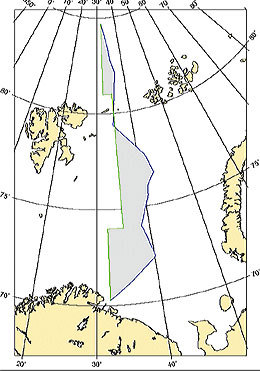
Agreed schematic chart illustrating the delimitation line according to the Treaty of 15 September 2010.
Agreed schematic chart illustrating the delimitation line according to the Treaty of 15 September 2010:
Chart showing the delimitation line (print version)

Chart illustrating the sector line, the median line and the disputed area:
|
|
Chart (print version) |