With a smartphone in the back pocket anyone can now reveal deforestation in tropical rainforests. The Forest Watcher app provides user access to satellite data showing changes in global forest cover, enabling them to rapidly react to threats and illegal forest activities.
Forest Watcher appen er testet ut av skogvoktere tilknyttet Jane Goodall Institute i Kasyoha Kitomi Forest Reserve i Uganda. Satellittbilder kan sammeholdet med hva som faktisk skjer på bakken for å avdekke ulovlig avskoging.
Credit: Jane Goodall Institute
The app is developed by Global Forest Watch, supported by the Norwegian Climate and Forest Initiative. Global Forest Watch - GFW - is an international collaborative project run by the World Resources Institute in Washington. Since 2013, Norway has contributed about NOK 80 million to the project.
Crucial in the fight against deforestation
-The project is very important because good data and good analyzes are crucial in the fight against deforestation of the tropical rainforest countries. And reducing deforestation is very imporant fighting climate change. As much as 30% of the climate solution can lie in the world's forests, says Norwegian Minister of Climate and Environment minister Vidar Helgesen.
-Now, we can closely watch actors who grow illegal crops, burn forests, or start mining in conservation areas, and it's a powerful tool, says Helgesen.
-Global Forest Watch gjør det mulig for alle å kikke aktører som ødelegger regnskog i kortene, sier klima- og miljøminister Vidar Helgesen.
Credit: Elisabeth Brinch Sand
Free access to satellite data
GFW combines satellite technology, existing forest information databases and ongoing contributions from people on the ground around the world.
-The main role of Global Forest Watch is to provide radical transparency about what is happening in the world's forests. For many years, people did not know what was happening in the woods, not even in their own back yard, and now we provide all this information for free in readily available formats, says Rachael Peterson, acting director at Global Forest Watch.
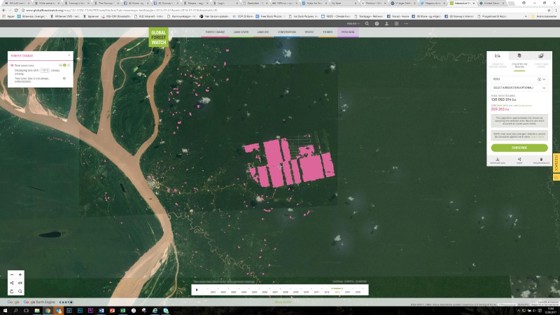
I Perus Amazonas avslørte satellittbilder at det ble bygget ut en gigantisk kakaoplantasje i uberørt regnskog. De rosa områdene viser områder som ble hugget på bare ett år. Bilder som dette er fritt tilgjengelig på Global Forest Watch.
Credit: Global Forest Watch
High resolution
Every year GFW publishes an analysis of how much forest is disappearing. The satellite images used have a resolution of 30x30 meters. Deforestation events can be observed in relatively small areas with these pictures, but all details are still not visible. But the system is being continuosly developed and improved. Maps of protected areas, mining concessions, logging, palm oil plantations, etc. are also available for selected countries. Thus, it can be revealed whether, for example, plantations are established or forest roads are built in protected areas. The database is expanded continuously with information from several countries.
Global Forest Watch also publish monthly deforestation alerts from selected countries. The warnings are based on analyzes done of changes in the world's tropical forests every 16 days. The satellite images used for this measurement are of relatively low resolution. The ambition is an information system that provides real-time information about the world's forests. Early alerts allow foresters or authorities to move out of their offices and investigate what actually happens in the forest. It's often in very inaccessible areas, without electricity or mobile networks. That makes the Forest Watcher app very valuable.
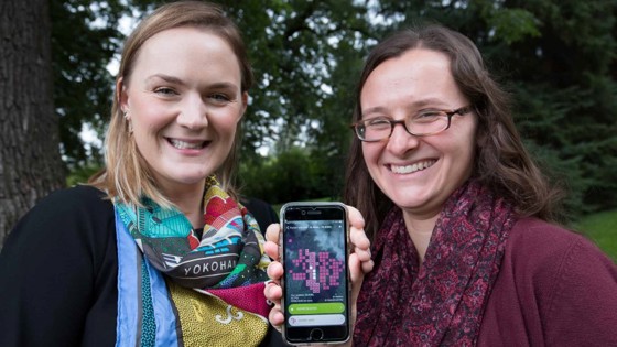
Med Forest Watcher appen på smarttelefonen kan alle få detaljert tilgang til satelittbilder av avskoging fra i hele verden, selv uten nett, forteller fungerende direktør Rachael Petersen og forskningsleder Michaela Weisse fra Global Forest Watch.
Credit: Snorre Tønset
Offline access
With the Forest Watcher app, all data from Global Forest Watch can be downloaded to your smartphone and used offline. Location data in the app enable the user to search places where satellite images indicate deforestation and verify what's happening on the ground. It may be illegal mining, harvesting, forest roads, forest fires, anything that is discovered. Users can take photos and take notes, store them in the app and upload the information to Global Forest Watch databases when back in the office.
-We hope the app can enable people to react more quickly to deforestation and can stop illegal activities while they happen, says Mikaela Weisse, research analyst at Global Forest Watch.
The app has been tested in the last year by Forest Guardians associated with Jane Goodall Institute in Kasyoha Kitomi Forest Reserve in Uganda and HAkA in Indonesia's Leuser.
Anyone interested in managing the world's forests sustainable, whether it be governments, business, researchers, indigenous peoples or environmental organizations, can benefit from GFW and the new app.
It can be downloaded free of charge by anyone for both iOS and Android. There is also a desktop version that can be downloaded here.