6 Management of unopened areas
Experience shows that the largest discoveries are made in the early phases of exploration of a petroleum province. This is natural since the largest mapped structures are often drilled first. The expectations of making new, large discoveries in the future are therefore greatest in the less-explored parts of the Norwegian Shelf.
Over the last 40 years, the Norwegian Continental Shelf has been mapped through gradual exploration. This means that we currently possess the best knowledge about the geology in the opened areas, but also that the possibilities for making new, large discoveries are reduced in these areas. The last time new acreage was opened for petroleum activity was in 1994 when the deepwater areas in the Norwegian Sea and south-western parts of Nordland VI were opened. The last large discovery on the Norwegian Shelf was Ormen Lange in 1997. The discovery was made in the area opened in 1994.
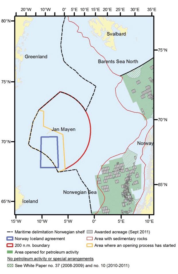
In the numbered licensing rounds carried out today, all area has been available for nominations from companies in several rounds. The most attractive parts of these areas have, in part, been well-studied. Opening new areas is necessary if we are to make important new discoveries and to maintain significant petroleum production, value creation, investment, employment and State income after 2020. The Government has therefore decided to initiate an opening process for the sea areas surrounding Jan Mayen and the part of the formerly disputed area that is located west of the delimitation line in the Barents Sea South.
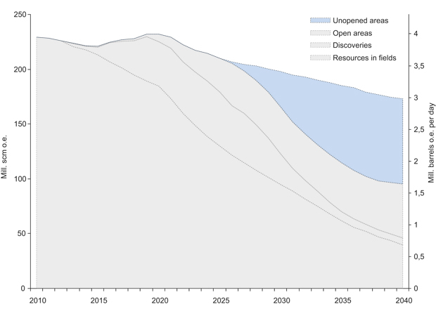
Figur 6.1 Possible production course on the Norwegian Shelf.
Kilde: The Ministry of Petroleum and Energy and the Norwegian Petroleum Directorate.
6.1 Timely opening of new area
Half of the areas where we expect that petroleum might be found are now open. There are thus large unopened areas remaining on the Norwegian Shelf. This means that there are possibilities for making significant discoveries in the future as well. The expected undiscovered resources in both opened and unopened areas have been estimated at 2 570 million scm o.e. by the Norwegian Petroleum Directorate (NPD). These numbers include the areas with a data basis which makes it possible to estimate undiscovered resources. The resource estimates therefore do not include the sea areas around Jan Mayen and the part of the formerly disputed area in the Barents Sea located west of the delimitation line.
The unopened areas on the Norwegian Continental Shelf are mainly located outside Northern Norway. The process that has been initiated to open new areas in the Barents Sea provides great possibilities for Finnmark county.
To achieve continuous activity on the shelf, it is important that oil and gas policies are knowledge-based, comprehensive and provide for a long-term management of the petroleum resources. New exploration acreage is an important prerequisite to maintain investment and the expertise in the industry, as well as maintaining production over time. This will in turn provide a foundation for long-term value creation and State income. The main objective in Norwegian petroleum policy is to facilitate profitable production of oil and gas in a long-term perspective.
Major discoveries and access to new prospective areas are important factors defining where large companies will carry out exploration activity. Exploration is a complex activity, and if the expertise moves away, it takes many years to rebuild it. Continuous exploration activity is therefore an important part of good resource management.
It takes a long time to start producing from new areas. A new area must go through an opening process, which entails an impact assessment, before the Storting can decide whether to open the area for petroleum activity. If the area is opened, history on the shelf shows that it will take 10-15 years following license awards until production. A decision to start an opening process today could result in production start-ups in 2025 or later.
The areas on the shelf are different. The lead time from opening until production is shorter in areas close to shore and developed infrastructure, as compared with more remote areas. These are important factors when determining petroleum policy.
6.2 Area overview
The sum of all Norwegian marine areas amounts to 2 140 000 km2. About half of the area is covered in sedimentary rocks that could contain petroleum, cf. Figure 6.2 and Table 6.1. The North Sea, the Norwegian Sea and the Barents Sea South, with certain exceptions, have been opened for petroleum activity. The areas opened as of today amount to 523 800 km2.
Several of these areas have a potential for petroleum activity. There are considerable differences between areas as regards knowledge level, distance to markets and existing activity, environmental assets and other user interests. The areas thus have various degrees of maturity and different challenges.
Unopened areas for new petroleum activity include the sea areas near Jan Mayen, the northeastern Norwegian Sea (parts of Nordland IV and V, Nordland VI and VII, Vestfjorden and Troms II), parts of Trøndelag I and II, Møre I, Skagerrak, the part of the formerly disputed area in the Barents Sea located west of the delimitation line, as well as a 35-km belt from the baseline along the coast from Troms II to the Russian border, the Barents Sea North /Arctic Ocean, the Ice edge, the Polar front, the Bjørnøy fan and a 65-km belt around Bjørnøya.
6.3 Opening history
The Norwegian Continental Shelf has been opened in three major rounds, in 1965, 1988 and 1994. In addition, smaller areas were opened in several rounds after 1979, cf. Box 6.1 and Figures 6.3 and 6.4.
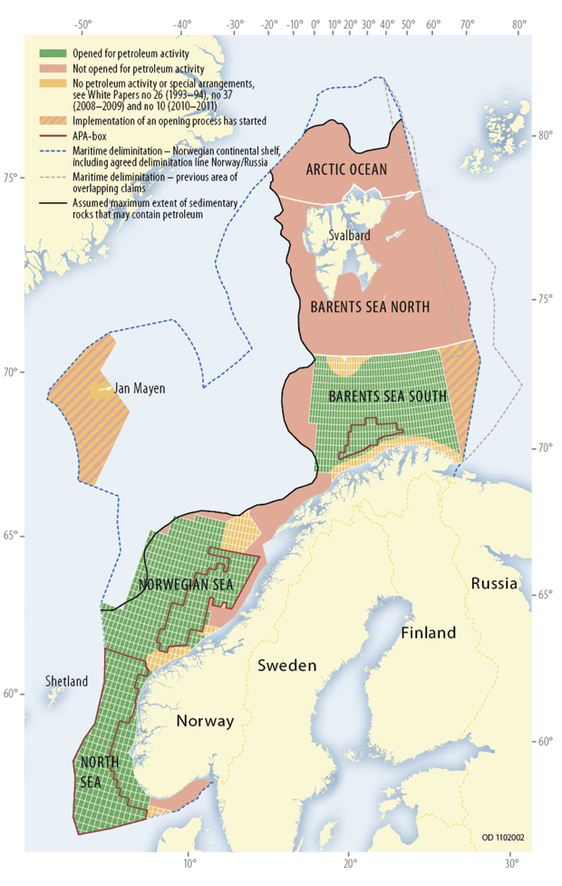
Figur 6.2 Opened and unopened areas on the Norwegian Shelf, estimated maximum spread of sedimentary rocks, for illustration purposes only.
Kilde: Norwegian Petroleum Directorate.
In 1965, large parts of the North Sea were opened for petroleum activity. Discoveries in this area enabled development of the industry and still contribute to the main part of production and State income. Petroleum activity was allowed north of 62 degrees latitude in 1979. In 1988, large parts of the Barents Sea were opened, while the deepwater areas in the Norwegian Sea were opened in 1994.
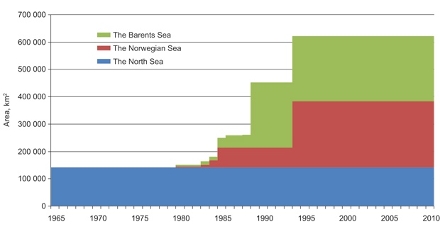
Figur 6.3 Opening history on the Norwegian Shelf.
Kilde: The Norwegian Petroleum Directorate.
Skagerrak was opened for petroleum activity in 1965 along with the rest of the North Sea, however, from the end of the 1970s, the area was not considered suitable for exploration activity. In 1994, a decision was made to allow the drilling of a limited number of exploration wells in the southwestern part of Skagerrak, before potentially raising the question regarding further opening with the Storting. Since 1994, no new areas have been opened for petroleum activity.
When an area has been opened for petroleum activity, the authorities can announce areas and award production licenses. The scope of the awards is determined independently of how large the areas opened for petroleum activity are. An effective way of identifying prospective exploration acreage is by opening large areas and gradually exploring the areas through sequential exploration. Awards in frontier areas will therefore often be limited to a smaller number of key blocks. This has been the main strategy for exploring new areas on the Norwegian Continental Shelf.
Tabell 6.1 Area overview of the Norwegian Shelf
Area accounts Norwegian Shelf (km2) | ||||
Total Norwegian sea areas | 2 140 000 | |||
Areas with sedimentary rocks (could contain oil and gas) | 1 312 000 | |||
Area open and available for petroleum activity | 523 800 | |||
Individual sea area, areas with sedimentary rocks (km2) | ||||
Unavailable area | ||||
Area opened and available for petroleum activity | Exempted through management plans | Unopened | Total | |
North Sea | 129 700 | 12 300 | 142 000 | |
whereof Skagerrak1 | 2 500 | 12 300 | 14 800 | |
Norwegian Sea2 | 204 100 | 28 600 | 56 300 | 289 000 |
whereof northeastern part3 | 17 600 | 41 600 | 59 200 | |
Barents Sea South4 | 190 000 | 44 100 | 78 000 | 313 000 |
Barents Sea North5 | 469 000 | 469 000 | ||
Jan Mayen, surrounding sea areas | 100 000 | 100 000 | ||
Total | 523 800 | 72 700 | 715 600 | 1 312 000 |
1 Skagerrak was opened for petroleum activity along with the rest of the North Sea. Parts of the area were subsequently closed (see text).
2 Including Troms II. Vestfjorden is not included.
3 Northeastern part is unopened part of Nordland IV, V, VI, VII and Troms II.
4 Including Bjørnøy fan and the delimitation line with Russia in the Barents Sea South.
5 Including the delimitation line with Russia in the Barents Sea North and the Arctic Ocean.
6.4 The unopened areas
6.4.1 Sea areas near Jan Mayen
The island of Jan Mayen is located on the Mid-Atlantic Ridge in the Norwegian Sea, north of Iceland. Jan Mayen is located 500 km east of Greenland, 550 km northeast of Iceland and 900 km from mainland Norway.
The Jan Mayen Ridge encompasses a micro continent stretching from the Jan Mayen Island to the northern tip of Iceland. The geological development of the area is connected to the formation of the northernmost part of the Atlantic Ocean. The Jan Mayen Island and the rocks below the island are entirely volcanic.
Technical description
The bedrock surrounding Jan Mayen is dominated by lava rocks and young sedimentary rocks. Below these rocks, we expect to find older sedimentary rocks. Areas where sedimentary rocks could occur cover up to 100 000 km2 in total. The water depth in the largest part of this area varies between 1000 and 2000 metres.
The volume of petroleum resources in the sea areas around Jan Mayen is uncertain, but the necessary geological preconditions for the formation of petroleum could be in place in the same way as on East Greenland and in the Møre basin. The NPD has acquired about 5800 km of 2D seismic in 1979, 1985 and 1988. The seismic data is collected in four data packages that have been made available to the industry. In addition, seismic data has been acquired by Iceland in 2001 and 2008. There is a need for acquiring new seismic data to define prospects and clarify the resource potential in the area.
There is a need to acquire new knowledge and carry out studies in the form of both geological and environmental mapping. The NPD will map the petroleum potential. The results from seismic acquisition and shallow drilling will strengthen the knowledge and increase understanding of the area’s geology.
Possible use of Jan Mayen
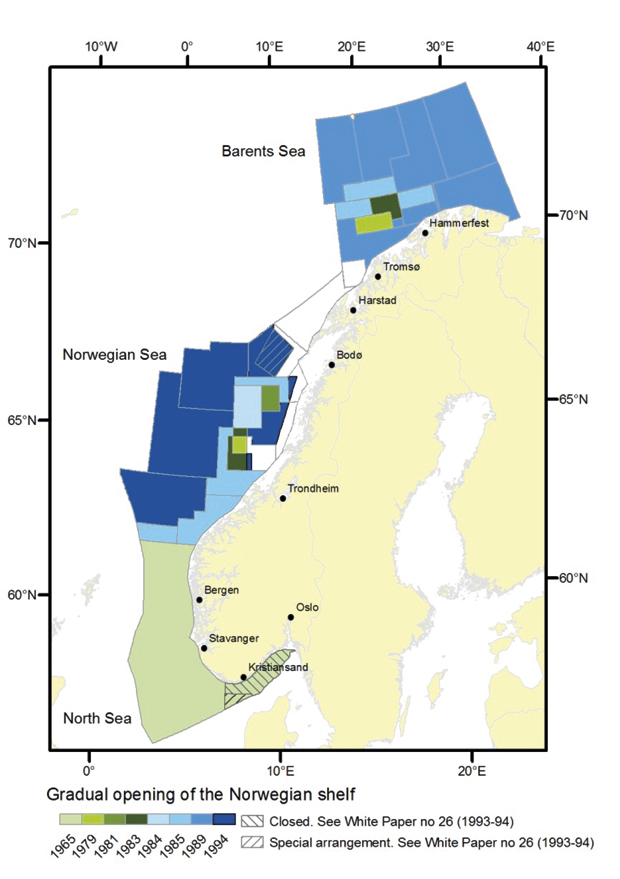
Figur 6.4 Gradual opening of the Norwegian Shelf.
Kilde: Norwegian Petroleum Directorate
The Jan Mayen nature reserve was established during the autumn of 2010. The nature reserve encompasses most of the island and the territorial waters, about 375 km2 of land area and 4315 km2 of marine area. The parts of the island where there is currently activity are not a part of the nature reserve.
Potential petroleum activity in the marine areas near Jan Mayen, could entail a need to use Jan Mayen for certain activities, for example to safeguard health, safety and the environmental concerns. Possible uses include establishing a base, preparedness storage, infrastructure such as roads and buildings including a quay facility, pier, heliport, petroleum treatment and storage facility and landfall for pipelines.
Potential petroleum activity is not envisaged within the current nature reserve. At present, the necessary type and scope of activity is uncertain. If weighty societal considerations require the framework for the use of Jan Mayen to be adjusted due to petroleum activity in the area, this can be accomplished by the King in Council making the necessary changes to the preservation provisions.
Boks 6.1 Gradual exploration
1965: The first announcement on the Norwegian Shelf. Announcement discussed in Storting White Paper No. 22 (1965–1966).
1979: Petroleum activity was allowed north of the 62 degrees in restricted areas of the Norwegian Sea (six blocks) and the Barents Sea (20 blocks on Tromsøflaket). Discussed in Storting White Paper No. 95 (1969–1970), Storting White Paper No. 30 (1973–1974), Storting White Paper No. 81 (1974–1975). Considered in Storting White Paper No. 91 (1975–1976) and Storting White Paper No. 57 (1978–1979), announcement discussed in Storting White Paper No. 46 (1979–1980).
1981: 12 blocks announced in the Norwegian Sea (Helgeland). Considered in Storting White Paper No. 57 (1978–1979), opened in Storting White Paper No. 67 (1980–1981), discussed in Storting White Paper No. 58 (1982–1983).
1983: 13 blocks announced in the Norwegian Sea (Haltenbanken). 19 blocks announced in the Barents Sea (Trømsøflaket). Discussed in Storting White Paper No. 58 (1982–1983).
1984: 30 blocks announced in the Norwegian Sea (Haltenbanken). Discussed in Storting White Paper No. 80 (1983–1984).
1985: 68 blocks announced in the Norwegian Sea (16 blocks in Møre south, 41 blocks in Trøndelag II, 16 blocks in Nordland III, 41 blocks on Møre) 70 blocks announced in the Barents Sea (20 blocks in Troms II, 30 blocks in Bjørnøya south, 20 blocks in Finnmark west) Discussed in Storting White Paper No. 80 (1983–1984). Opening proposed in Storting White Paper No. 79 (1984–1985).
1986–1987: Strategic blocks in the Barents Sea discussed in Storting White Paper No. 79 (1984–1985) and Storting White Paper No. 46 (1986–1987)
1988: The majority of the Barents Sea South is opened for petroleum activity. Was submitted in Storting White Paper No. 79 (1984–1985). Opening proposed in Storting White Paper No. 40 (1988–1989).
1994: New deepwater areas are opened in the western part of the Norwegian Sea, including the western part of Nordland VI. At the same time, Skagerrak is closed for petroleum activity. Considered in Storting White Paper No. 26 (1993–1994).
After 1994, no new areas have been opened for petroleum activity on the Norwegian Shelf.
Assessment and conclusion
The Jan Mayen Ridge is a new petroleum province. An opening process has started in the sea areas on the Norwegian side of Jan Mayen with the aim of awarding production licenses. This is the first time this marine area has been assessed as regards potential petroleum activity. The opening process consists of two main elements, a geological mapping and an impact assessment. The draft program for the impact assessment was submitted for public consultation on 14 December 2010. The deadline for comments on the draft program expired on 22 March 2011. Twenty-three submissions were received. Further activities in the assessment process will include:
Determining the program
Defining and planning field studies
Carrying out field studies
Analysing and reporting updated knowledge basis
Assessment of basis for petroleum activity, establishment of scenarios
Impact assessment – relevant issues associated with petroleum activity
Public consultation regarding the impact assessment
Presenting a White Paper for the Storting
The course of the various activities will be determined during the process. The field work and seismic surveys, in particular, will be crucial as regards the timing of several other activities. The Government has allocated NOK 10 million in 2011 for environmental mapping. Such mapping could include surveys at sea to increase understanding of the seabed and mapping seabirds and fauna in the area. The ongoing impact assessment process will clarify the details. It is important to strengthen the knowledge concerning geology in the area by collecting new data. Seismic acquisition and shallow drilling will be necessary in order to assess the prospectivity and the future possibilities for petroleum activity in the area. The NPD will carry out these activities starting in 2011.
Figur 6.5 The Jan Mayen area
Kilde: Norwegian Petroleum Directorate
The Government will:
Carry out an opening process in the sea area near Jan Mayen, comprising environmental and resource mapping, including seismic data acquisition and shallow drilling.
Delimitation of the continental shelf between Norway and Iceland
Figur 6.6 The northeastern Norwegian Sea.
Kilde: Norwegian Petroleum Directorate.
On 22 October 1981, Norway and Iceland entered into an agreement regarding the continental shelf in the area between Iceland and Jan Mayen (Storting Proposition No. 61 (1981–1982)). The agreement stipulates that the delimitation line between the parties’ sectors of the continental shelf in the area between Iceland and Jan Mayen shall coincide with the delimitation line for the countries’ economic zones. Furthermore, the agreement stipulates provisions regarding special cooperation in the event of future petroleum activity in a more precisely defined area between Iceland and Jan Mayen. This area covers a total of 45 470 km2. Of this, 32 750 km2 is located on the Norwegian side of the delimitation line and 12 720 km2 on the Icelandic side.
In 2006, Icelandic authorities submitted a strategic impact assessment as preparation for petroleum activity on the Icelandic shelf. In 2009, a licensing round was carried out in the Icelandic sea area. The licensing round did not result in awards. Iceland is working on a new licensing round, with the aim of awarding production licenses in 2012. There will be a continuous dialogue between Norwegian and Icelandic authorities in connection with the petroleum activity on the Icelandic side and implementation of the opening process for Norwegian marine areas near Jan Mayen.
In the part of the cooperation area located north of the delimitation line (Norwegian Continental Shelf), Iceland has been given access to participate with an interest of 25 per cent in connection with exploration and production of petroleum deposits. Iceland may make this decision once a decision is made to develop a new field. In the cooperation area south of the delimitation line (Icelandic continental shelf) Norway has been given access to participate in the petroleum activities with a corresponding interest, but only from and including the time a license award.
The Government will:
Continue the dialogue with Icelandic authorities to safeguard Norwegian interests in the cooperation area near Jan Mayen.
Tabell 6.2 Overview of unopened area in the Norwegian Sea
Nordland IV | 5 600 km2 |
Nordland V | 4 000 km2 |
Nordland VI | 21 600 km2 |
Nordland VII | 23 400 km2 |
Troms II | 5 300 km2 |
Trøndelag I | 7 000 km2 |
Trøndelag II | 2 000 km2 |
Møre I | 9 000 km2 |
Nordland IV | 5 600 km2 |
Nordland V | 4 000 km2 |
6.4.2 The Norwegian Sea
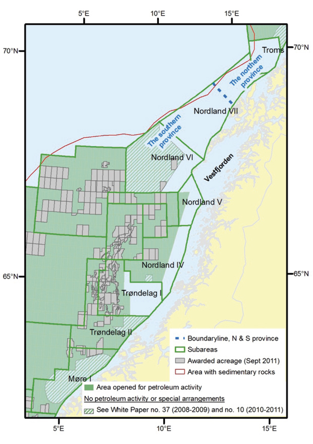
An area northeast in the Norwegian Sea has not been opened for petroleum activity. This area includes acreage in Nordland IV, V, VI, VII and Troms II. In this White Paper, these areas are called the northeastern Norwegian Sea. Farther south along the coast there are also areas in Trøndelag I and II, as well as near Møre where licensing rounds will not be announced until the management plan for the Norwegian Sea is updated, in 2014 at the latest. In total, this amounts to a considerable area, cf. Table 6.2. This Chapter also addresses the part of Nordland VI that is opened, but where there will be no petroleum activity during this parliamentary term.
Technical petroleum description of the northeastern Norwegian Sea
The geology in the northeastern Norwegian Sea is varied and complex. The water depth is generally less than 400 metres in this area. The continental slope to the west and north-west plunges to more than 2500 metres. In terms of petroleum geology, the area can be divided into a southern province containing Nordland IV, Nordland V, Nordland VI and southern Nordland VII, and a northern province containing the northern part of Nordland VII and Troms II.
The seismic data basis in the northeastern Norwegian Sea varies in both scope and quality. From 2007-2009, the NPD carried out acquisition of 2D seismic, 3D seismic and other data relating to the subsurface in Nordland VII and Troms II. 2D seismic has also been acquired in this area previously. In addition, several shallow drillings have taken place and a wildcat well has been drilled. Several wildcat wells have been drilled just outside the area. Based on new and previously collected data, the NPD has mapped the areas and calculated the resource potential.
The main characteristics of the geology, resource estimate and value assessment of various resource outcomes are described in separate reports from the NPD1. Nordland VI appears to be the most prospective area for petroleum resources. At the same time, the mapping work shows that the unopened parts of Nordland V, Nordland VII and Troms II also have a petroleum potential. The mapping indicates that the necessary geological preconditions for making a discovery are present, and that the possibilities of making discoveries are considered good. Based on new mapping, prospect evaluation and exploration model analysis, the total expected undiscovered resources are estimated at just over 200 million scm o.e. The range of uncertainty is estimated at between 76-371 million scm o.e. The majority of the resources are expected in Nordland VI. Nordland VII and Troms II have an overall expected resource estimate on par with Nordland VI.
Other areas in the Norwegian Sea
The Møre coast was subject to several periods of uplift and erosion. This has resulted in the removal of thick sediment packages. The uplift and skewed position of the layers could have led to hydrocarbon leaks.
The seismic data coverage on Møre is relatively good. Several wildcat wells were drilled and shallow drilling was carried out in the area before it was exempted for petroleum activity. Hydrocarbons were not proven in these wells, but several small discoveries were made just south of the area. Storting White Paper No. 37 (2008-2009) Comprehensive management of the marine environment in the Norwegian Sea (management plan) states that “Until the management plan is updated, in 2014 at the latest, licenses will not be announced on the Møre banks. The Government will then re-assess this issue”.
The seismic data coverage in Trøndelag I and II is relatively good. A number of wildcat wells that are relevant for this area have been drilled on the Trøndelag platform. In the unopened part of Trøndelag I, a scientific, shallow well has been drilled. The shallow boreholes outside the Trøndelag and Nordland coast also provide useful information concerning the rocks’ composition and age. The most critical element for prospectivity is whether mature source rocks exist. Several dry wildcat wells have been drilled on the Trøndelag platform west of the unopened area. However, the presence of oil and gas in the unopened area cannot be precluded.
Assessment and conclusion
Since 1984, various parts of the northeastern Norwegian Sea have been impact assessed, cf. Box 6.2. Parts of Nordland VI have been opened, but there will not be petroleum activity there during this Storting period. In addition, no new blocks will be announced in the area in the period. The other areas have not been opened.
No impact assessments pursuant to the Petroleum Act will be carried out in Nordland VII and Troms II and unopened parts of Nordland IV, V and VI during this Storting period. The Ministry will carry out knowledge acquisition concerning the effects of petroleum activity in unopened parts of Nordland IV, V, VI, VII and Troms II. The knowledge acquired must be suited for use in a potential impact assessment regarding petroleum activity, and must be suited for use as a basis for the next update of the management plan. The work will start quickly. The knowledge acquisition topics will e.g. include societal and industrial effects and spin-off effects, including effects on tourism and the fishery industry. The topics will be determined in cooperation with regional and local authorities, sector authorities and specialist environments.
In unopened parts of Nordland IV and V there will also be a need for strengthening the knowledge regarding petroleum resources through seismic surveys and other geological data acquisition, headed by the NPD and in dialogue with the fishing industry and fishery authorities. The NPD prepares data packages with relevant seismic from Nordland VI, VII and Troms II which are to be marketed for sale.
Figur 6.7 Barents Sea South.
Kilde: Norwegian Petroleum Directorate.
Based on the NPD’s new mapping, Nordland VI appears to be the most prospective area for petroleum resources. Nordland VII and Troms II have a total expected resource estimate on par with what is expected in Nordland VI. The resource estimate for oil is greater than for gas in Nordland VI and VII. The greatest probability of gas is in Troms II.
The Government will:
Carry out knowledge acquisition regarding effects of petroleum activity in unopened parts of Nordland IV, V, VI, VII and Troms II. The knowledge being acquired must be suited for use in a potential impact assessment regarding petroleum activity and must also be suitable as a basis for the next update of the management plan.
Strengthen the knowledge regarding petroleum resources in unopened parts of Nordland IV and V through seismic surveys and other geological data acquisition carried out by the NPD and in dialogue with the fishing industry and fishery authorities.
Offer data packages with relevant seismic data from Nordland VI, VII and Troms II for sale.
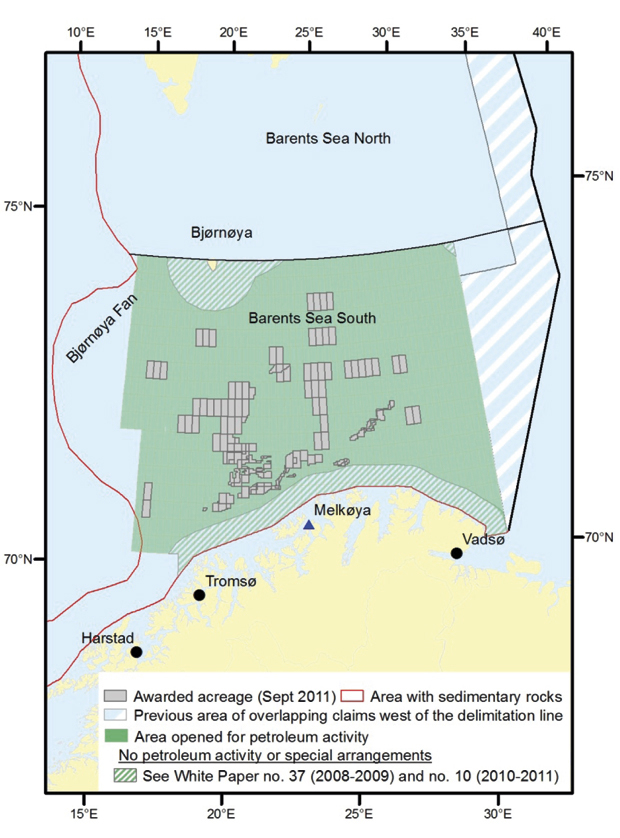
6.4.3 Barents Sea South
The parts of the Barents Sea located south of 74°30’ N which are not currently available for petroleum activity, are discussed in this Chapter. This applies to the part of the formerly disputed area located west of the delimitation line, an area to the west that is also covered by sedimentary rocks called the Bjørnøy fan, a 65-km zone around Bjørnøya, the areas by the Ice edge and Polar front and the coastal zone along Troms and Finnmark. The water depth in the Barents Sea South averages less than 400 metres, while the continental slope to the west by the Bjørnøy fan is more than 2000 metres deep.
Technical description
Hydrocarbons have been proven to the east and west of the formerly disputed area. This provides hope that there could also be hydrocarbons in the part located west of the delimitation line. The data basis is too poor to provide a resource estimate for the area. In the early 1980s, an agreement was entered between Russia and Norway regarding a moratorium on further petroleum activity in the disputed area. Prior to the moratorium, the Norwegian side acquired certain seismic lines east of the sector line. These lines show that geological formations located west of the sector line continue into the area towards the centre line. On the Norwegian side, west of the agreement area, several minor discoveries have been made. On the Russian side, east of the agreement area, very large gas discoveries have been made, including Sjtokman and Kildinskoya. There are possibilities for petroleum resources in the new areas on the Norwegian side as well. There is a need for more data in the area to ensure good resource mapping and prospect definition. The NPD recommends acquiring 2D seismic first, potentially followed by aeromagnetic and gravimetric data2.
The NPD does not have data for the area around Bjørnøya which makes it possible to establish a resource estimate for the area. The data basis is limited by the Ice Edge and Polar Front, and the petroleum potential in these areas is therefore uncertain. The NPD believes that the western continental slope (Bjørnøy fan) has a limited petroleum potential.
The coastal zone from Troms II to the delimitation line in the Barents Sea is considered to have a limited petroleum potential.
Boks 6.2 Unopened parts of the Norwegian Sea – history
1984: Troms II was impact-assessed, the area was not opened.
1989: The area was included in the assessments carried out prior to the opening of the Barents Sea South. The area was not proposed for opening.
1994: Nordland IV, V and VI were impact-assessed and partially opened. Areas near the coastline were not opened. An opportunity to drill six exploration wells was granted in an area in the middle of Nordland VI. Nordland VII was not opened.
1996: Two production licenses were awarded in Nordland VI.
2001: The second well in Nordland VI was interrupted. A decision was made to carry out an assessment of consequences from year-round petroleum activity in the area Lofoten – Barentshavet (ULB) before any further petroleum activity in these areas.
2003: ULB submitted. A decision was made to not open Nordland VI for any further petroleum activity. Furthermore, that an assessment of further activity should be made in connection with the comprehensive management plan for the Barents Sea.
2006: Storing White Paper No. 8 (2005–2006) Comprehensive management of the marine environment in the Barents Sea and the waters off Lofoten (management plan) determines that petroleum activity must not be started in Nordland VI during the 2005-2009 Storting period. Furthermore, that petroleum activity must not be started in Nordland VII and Troms II in the current Storting period, but that the question as regards petroleum activity in these areas will be considered in connection with a revision of the management plan.
2009: When submitting Storting White Paper No. 37 (2008–2009) Comprehensive management of the marine environment in the Norwegian Sea (management plan), a decision was made to not start an opening process in the northern part of the coastal zone. Furthermore, that this question should be considered in connection with the update of the management plan for the Barents Sea – Lofoten.
2011: In Storting White Paper No. 10 (2010–2011) Updating the management plan for the marine environment in the Barents Sea and the waters off Lofoten, the Government decided that there should not be petroleum activity in the opened parts of Nordland VI during this Storting period, and furthermore, that an impact assessment should not be started according to the Petroleum Act in Nordland VII and Troms II and in unopened parts of Nordland IV, V and VI. The Ministry of Petroleum and Energy will carry out knowledge acquisition regarding effects of petroleum activity in unopened parts of Nordland IV, V, VI, VII and Troms II. The knowledge being acquired must be suitable for use in a potential impact assessment regarding petroleum activity.
Assessment and conclusion
The southern part of the Barents Sea is generally open for petroleum activity, with the first announcement made in 1979. Increasing interest in the area is apparent both through numbered rounds and awards in pre-defined areas (APA). There are currently 53 active production licenses in the Barents Sea, and 86 exploration wells have been drilled. So far, Snøhvit is producing and Goliat has been approved for development. Skrugard is a new discovery that could form the basis for a new, independent development in the area. In order to further develop the area, it is important to facilitate continuous activity.
In connection with the update of the comprehensive management plan for the marine environment in the Barents Sea – Lofoten, Storting White Paper No. 10 (2010–2011), adjustments were made in the framework for petroleum activity in the Barents Sea South. A decision was made to allow for petroleum activity in the area from 35-50 km from the coast from Troms II to the border with Russia; including Tromsøflaket. The same applies to Eggakanten (the area from the edge of Tromsøflaket and north). For other areas, the framework was continued: In the areas by the Ice edge and Polar front, within a 65-km belt around Bjørnøya and in a 35-km belt from the baseline along the coast from Troms II to the Russian border, petroleum activity will not be started during this Storting period.
The NPD considers the part of the formerly disputed area located west of the delimitation line with Russia interesting as regards petroleum activity on the Norwegian Shelf. Hydrocarbons have been proven to the east and west of the area. This gives hope that there might also be hydrocarbons in the part of the Barents Sea South located west of the delimitation line. The data basis in the area is very limited and it is therefore not possible to assess the resource potential. There is thus a need for more data from the area. Initially 2D seismic and potentially aeromagnetic and gravimetric data will be collected.
In connection with updating the comprehensive management plan for the marine environment in the Barents Sea and Lofoten, Storting White Paper No. 10 (2010-2011), a decision was made for the Ministry to start an impact assessment according to the Petroleum Act with the aim of awarding production licenses in the formerly disputed area west of the delimitation line in the Barents Sea South. If the impact assessment provides a basis for it, the Government will submit a Storting White Paper which recommends opening these areas for petroleum activity. The impact assessment will start when the agreement between Norway and Russia regarding maritime delimitation and cooperation in the Barents Sea and Arctic Ocean enters into force.
The Government will:
Start an impact assessment according to the Petroleum Act with the aim of awarding production licenses in the formerly disputed area west of the delimitation line in the Barents Sea South when the agreement with Russia regarding maritime delimitation and cooperation in the Barents Sea and Arctic Ocean has entered into force.
When the agreement with Russia regarding maritime delimitation and cooperation in the Barents Sea and Arctic Ocean enters into force, start data acquisition in the formerly disputed area west of the delimitation line in the Barents Sea South.
Facilitate new petroleum activity in the area from 35–50 km from the coast from Troms II to the border with Russia and in Eggakanten by including these areas in future licensing rounds.
Boks 6.3 Delimitation line with Russia
The maritime delimitation between Norway and Russia in the Barents Sea and the Arctic Ocean has been the object of negotiations for nearly 40 years. The agreement between Norway and Russia regarding maritime delimitation and cooperation in the Barents Sea and Arctic Ocean was signed in Murmansk on 15 September 2010. During the winter of 2011, both countries’ national assemblies consented to ratification of the agreement. Exchange of the ratification documents took place in Oslo on 7 June 2011. The agreement will enter into force thirty days following the exchange of ratification documents.
The agreement regarding maritime delimitation and cooperation entails that the disputed area of about 175 000 square kilometres will be split into two approximately equal parts. The agreement also contains provisions regarding cooperation between the parties should an oil or gas deposit extend across the delimitation line. If such transboundary petroleum deposits are discovered, the agreement contains detailed rules and procedures with the aim of ensuring prudent and cost-efficient management of the petroleum resources.
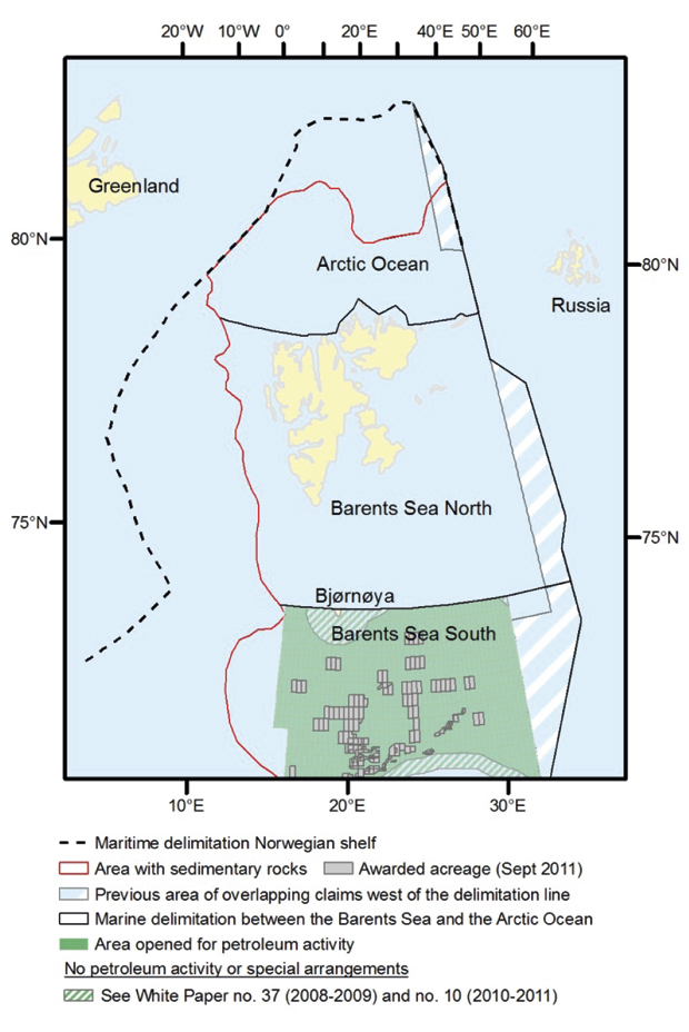
6.4.4 The Barents Sea North and Arctic Ocean
The Barents Sea North encompasses the marine areas between the Norwegian Sea in the west and the maritime delimitation line with Russia to the east. To the south, the area stops at 74°30’ N. To the north, the area stretches north of Svalbard. The area of the entire Norwegian part of the Barents Sea North as well as the parts of the Arctic Ocean with sedimentary rocks, is roughly 489 100 km2. The area of the new part of the Barents Sea North is 35 000 km2. The water depth on the shelf is generally less than 400 metres, while the continental slope to the west and north plunges down to more than 2500 metres. During winter, large parts of the sea area are covered in drift ice.
Figur 6.8 The Barents Sea North and the Arctic Ocean.
Kilde: Norwegian Petroleum Directorate.
Over the last 15 years, the scientific exploration of the Arctic Ocean has grown significantly. Countries such as the US, Russia, Germany and Sweden are carrying out extensive, continuous activity throughout the Arctic Ocean. The project of mapping the shelf’s outer limit has made the NPD an interesting player to the international research communities in the area. The reason behind this is that the Norwegian authorities have had their own data and activity to reference. In this context, the NPD has had extensive cooperation with the State-owned Russian mapping institutes.
Technical description
Researching the petroleum potential in unopened areas of the Barents Sea has had a low priority for many years, but data acquisition has been carried out by the NPD. The surveys show that there is a large area where sedimentary rocks are present. The data basis in the Barents Sea North is old and has poor coverage.
Assessment and conclusion
Interest in the northern areas is increasing. The Government has defined the northern areas as its most important strategic priority area as regards foreign policy. Presence, activity and knowledge form the foundation of the efforts. The goal is for Norway to be at the top internationally as regards developing knowledge about, for and in the northern areas. Furthermore, the goal is for Norway to be at the forefront as a steward of the environment and natural resources in the northern areas. We currently possess limited knowledge regarding the Barents Sea North and the Arctic Ocean. A key element in the northern strategy is carrying out projects to develop new knowledge.
Boks 6.4 Determining the outer limit of the Norwegian Continental Shelf
In its recommendation from April 2009, the UN’s Continental Shelf Commission granted approval for Norway to determine the border for its continental shelf outside 200 nautical miles in three areas: in the Nansen basin in the Arctic Ocean north of Svalbard, in the Loophole between Norway and Russia in the Barents Sea and in the Banana Hole of the Northeast Atlantic, i.e. the area outside the 200-mile border between mainland Norway and Jan Mayen and Greenland.
The shelf area outside 200 nautical miles in the Nansen basin is about 14 000 km2 and covers deep sea areas with depths of about 4000 metres. Based on joint interests between Norway and Russia regarding the northern delimitation of the continental shelf, technical agencies in the two countries cooperated on the mapping of the area.
After the agreement regarding the delimitation line between Norway and Russia was in place, it is now clear that the Norwegian Shelf in the formerly disputed area will be about 88 000 km2, of which about 8 600 km2 are located in the Barents Sea Loophole. The clarification has great significance for achieving an effective management of this part of the shelf in the future, and will make it easier for Norwegian authorities to cooperate with Russian authorities in the area.
The Norwegian Continental Shelf outside 200 nautical miles in the Banana Hole of the Northeast Atlantic can amount to up to 250 000 km2. In the southern part of this area, however, Iceland and Denmark with the Faroe Islands are aiming to document a continental shelf outside 200 nautical miles. In September 2006, a negotiation protocol was signed between Norway, Iceland and Denmark/the Faroe Islands regarding the approach for delimitation of the continental shelf and in the southern part of the Banana Hole. The protocol must be followed up with formal delimitation agreements when the Continental Shelf Commission has issued its recommendation to Iceland and Denmark/the Faroe Islands for this area. If Iceland and Denmark/the Faroe Islands receive recommendations from the Continental Shelf Commission along the lines of their shelf proposals, the Icelandic and Faroese shelf areas will amount to about 60 000 km2 in total. The Norwegian Continental Shelf in the Banana Hole will then be about 190 000 km2. The majority of this area covers deepwater areas of 3000-3500-metres.
The deepwater areas in the Arctic Ocean and in the Banana Hole that are now included in the Norwegian Shelf outside 200 nautical miles, are not considered to be prospective areas for oil and gas. They could, however, contain other types of resources that are not yet known. The part of the formerly disputed area that is now located on the Norwegian side of the delimitation line, is however, part of the shallow shelf area in the Barents Sea, and thus a part of the prospective parts of the Norwegian Continental Shelf.
For utilisation of the inanimate resources on the continental shelf outside 200 nautical miles from the baselines, a special rule relating to a duty for relinquishment of a production fee according to Article 82 of the Law of the Sea Convention applies to the advantage of developing countries and landlocked countries. A more detailed description of the obligations in Article 82 is provided in Storting Proposition No. 37 (1995-1996) relating to consent for ratification of the Law of the Sea Convention.
In the 21st licensing rounds, new blocks were announced in the Vøring plateau, of which four are located outside 200 nautical miles from the baseline. This could actualise Norway’s duty to relinquish a production fee according to Article 82 of the Law of the Sea Convention. The fee obligation enters into force during the sixth production year at a production location, and will amount to one per cent of the value of the amount of production at a production location during the first year. Following the first year, the rate is increased by one percentage point for every subsequent year until the twelfth year, and will then remain at seven per cent for the remainder of the production duration. The fee obligation lies with the Norwegian State, but can also be transferred directly to the companies.
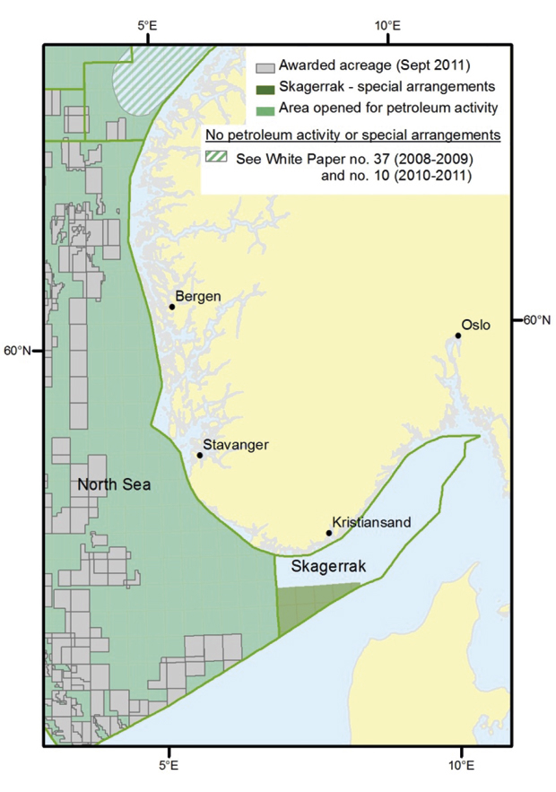
6.4.5 The North Sea and Skagerrak
Skagerrak is the name of the sea area between Denmark, Sweden and Southern Norway. In this description, Skagerrak is limited to the area between the baseline and border with Denmark and Sweden, east of 7° E, cf. Figure 6.10. Skagerrak’s total area amounts to 14 800 km2, the unopened part of Skagerrak is 12 300 km2. The water depth in Skagerrak varies from 100 to about 750 metres.
Figur 6.9 The North Sea.
Kilde: Norwegian Petroleum Directorate.
Technical description
In the northern part of the area, which has not been opened, a limited amount of seismic data has been acquired. This data is older and of poor quality. There is a need to acquire new seismic data if a new geological mapping of the area is to be carried out. A wildcat well has been drilled just west of Skagerrak. No hydrocarbons or source rock were proven in the well, but good reservoir rocks were discovered.
The NPD assumes the largest potential for oil and gas deposits is located in the southern part of Skagerrak.
Assessment and conclusion
In 1987, preparations for an impact assessment were started for all of Skagerrak. The impact assessment was submitted in Storting White Paper No. 26 (1993–1994). Based on this, the Storting decided to make a part of Skagerrak available for exploration activity in 1994. This area located north of the line 57°40’ N and east of line 8°30’ E, was made available for exploration activity, with special conditions. Permission to drill up to four exploration wells can be granted in the area, before potentially raising the question regarding further opening with the Storting. The other parts of Skagerrak have not been opened for petroleum activity.
In connection with the authorities’ consideration of the question regarding exploration drilling in Skagerrak, Swedish authorities established contact and wanted additional assessments of possible consequences for the Swedish west coast. After an overall assessment of environmental and fishery considerations, as well as the activity level in the sector, production licenses were not awarded in Skagerrak.
Several dry wells have been drilled just west of the area. The greatest potential in the area is located in the southern part.
The Government will:
Consider the future need for new knowledge regarding petroleum resources in Skagerrak.
6.4.6 Elements in an opening process
The Government has chosen to establish a comprehensive management plan as a tool for decisions associated with utilisation of the sea areas. The objective is to facilitate value creation and co-existence between the respective industries through sustainable use of resources and ecosystem services. As the same time, the structure, function and productivity of the ecosystems must be maintained, and the natural diversity must be preserved.
Before we can have petroleum activity in a sea area, an opening process must be carried out. The Petroleum Act provides a legal basis for the resource management, including starting opening processes. The Petroleum Act is administered by the petroleum authorities. Only when an area is opened will production licenses be awarded according to stipulated provisions and certain environmental and fishery considerations.
Elements in an opening process
Before an area can be opened for petroleum activity, an opening process must be carried out. An opening process has the objective of assessing the technical basis on which the Storting’s decision is based. Deciding whether or not to open an area is carried out by the Storting.
An opening process consists of two main elements. One element entails mapping the geology and thus the resource potential in the area. The initial mapping of the geology could, for instance, entail seismic data acquisition, drilling shallow wells, electromagnetic surveys or aeromagnetic surveys. The surveys are normally carried out by the NPD.
The other part is an assessment of the industrial, environmental and other societal effects of petroleum activity in the area. This includes the possible risk of pollution, as well as the financial and social effects the petroleum activity might have. Such an evaluation is carried out through an impact assessment under the direction of the Ministry of Petroleum and Energy. An impact assessment is a crucial part of an opening process.
In the first part of the impact assessment process, a draft study program is prepared. This contains a description of what will be assessed. The draft study program must be submitted for public consultation. Based on the program proposal and submissions, the Ministry then determines the study program.
After determining the study program, there will be a need to strengthen the knowledge regarding e.g. the environmental assets in the relevant area. Examples include mapping seabirds, the seabed, pelagic species and the existing fauna. The need for data acquisition will, however, depend on the knowledge status within each discipline.
Based on the knowledge concerning environmental assets and other relevant social conditions, as well as viewpoints regarding potential future petroleum activity in the area, the actual impact assessment is carried out.
Topics of the impact assessment could include:
Factors as regards solutions, design and operations
Societal consequences
Regular discharges to sea
Physical intervention
Consequences for other activities
Incidents involving acute pollution
The impact assessment and underlying reports are submitted for public consultation.
The assessments, submissions and other relevant information that has emerged during the process form a basis for a report to the Storting. Possible conditions for an opening are discussed in the Storting White Paper. The Storting will make a decision regarding whether or not to open all or parts of the area in question, including any conditions.
Boks 6.5 Regarding opening processes in the Petroleum Act
Section 3-1 of the Petroleum Act states the following regarding opening new areas:
«Prior to the opening of new areas with a view to granting production licenses, an evaluation shall be undertaken of the various interests involved in the relevant area. In this evaluation, an assessment shall be made of the impact of the petroleum activities on trade, industry and the environment, and of possible risks of pollution, as well as the economic and social effects that may be a result of the petroleum activities. The opening of new areas is a matter which shall be put before local public authorities, central trade and industry associations and other organisations which may be presumed to have a particular interest in the matter. Furthermore it shall be made known through public announcement which areas are planned to be opened for petroleum activities, and the nature and extent of the activities in question. Interested parties shall be given a period of time of no less than 3 months to present their views. The Ministry decides on the administrative procedure to be followed in each individual case.»