7 Norway’s space-related ground infrastructure
Many earth observation satellites move in polar orbit, circling the earth 14 times per day. Our northern location allows us to receive the data from most of these satellites. Norway’s position – along with our tradition of successfully building and operating infrastructure in the Arctic and Antarctic – has given rise to a cluster of competitive companies offering ground-based services to research institutes and satellite operators. Space-oriented infrastructure has been established in Svalbard, on Jan Mayen Island, in mainland Norway and in Queen Maud Land in Antarctica. Some of the infrastructure is uplink and downlink equipment that represents a market in itself. Other infrastructure is part of the value chain in Norwegian services. Space-related infrastructure attracts other activities and enterprises to the polar regions while simultaneously contributing importantly to Norwegian interests in these areas. The placement of this ground infrastructure also represents a significant component of Norway’s international space collaboration.
Textbox 7.1 SvalSat
SvalSat is the largest ground station on earth for control of polar-orbiting satellites and data reception from them. Many of the satellites provide meteorological data essential to accurate weather forecasting. The European weather satellite organisation EUMETSAT and the US National Oceanic and Atmospheric Administration (NOAA) are heavy users of SvalSat’s downlink services.
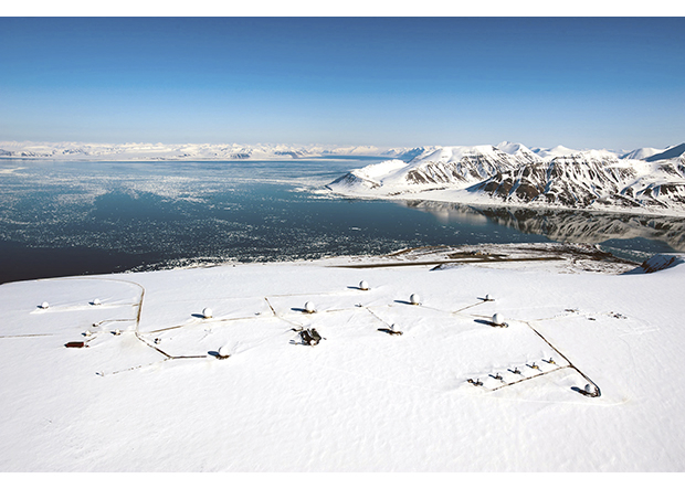
Figure 7.1 SvalSat
Source KSAT
Svalbard
Svalbard is the only easily accessible place in the world for communicating with polar-orbiting satellites on every one of their daily orbits. The hub of space activities in Svalbard is the Svalbard Satellite Station (SvalSat), owned and operated by KSAT. SvalSat is the world’s largest ground station for communication with satellites in polar orbit. Japanese research and earth observation satellites are among those whose data are downlinked here. Of the many antennas at SvalSat, some are owned by KSAT and others by major customers such as NASA, the European Union (Galileo and EGNOS) and EUMETSAT. SvalSat is the main ground station for the US weather satellite Suomi NPP, which was launched in the autumn of 2011. SvalSat will also be crucial to the Landsat 8 environmental monitoring satellite and the IRIS solar research satellite, both owned by the United States and launched in 2013.
National and international organisations alike take part in space-related research in Svalbard. Notable Norwegian infrastructure includes the Norwegian Mapping Authority’s geodetic observatory at Ny-Ålesund, the Kjell Henriksen Observatory outside Longyearbyen (for observation of the aurora borealis and space weather phenomena) and the Norwegian portion of the international EISCAT Svalbard Radar. The German and French space agencies, DLR and CNES, have positioned some infrastructure in Svalbard for improved tracking of their satellites’ orbits.
Collaboration with the US organisations NASA and NOAA prompted the installation of fibre-optic cable to Svalbard in 2004. The subsea fibre-optic connection between Svalbard and mainland Norway is owned by Norwegian Space Centre Properties. The cable must be regarded as a critical part of Norway’s space infrastructure; it also provides important services to the population of Svalbard. In 2010, the Government commissioned Uninett to install a fibre-optic cable between Ny-Ålesund and Longyearbyen. This cable is scheduled to be ready in 2013–2014. The increase in space-based activity in Svalbard is drawing increased attention from scientific communities elsewhere in Norway and around the world. That affects other activities in Svalbard, including businesses in other sectors. As stated in Report No. 22 (2008–2009) to the Storting: Svalbard, the Government aims to invest in space activities as part of Svalbard’s future livelihood.
The Svalbard Treaty of 9 February 1920 establishes certain regulations in Svalbard that may have implications for space-related infrastructure. Pursuant to Norway’s Telecommunications Act and § 3 and § 4 of its Svalbard Act, the Norwegian regulation on establishing, operating and using satellite earth stations contains special provisions for Svalbard. To ensure that earth-station operations are consistent with the Svalbard Treaty’s prohibition against using the archipelago for «warlike purposes», Article 3 of the regulation establishes rules for the authorisation and use of earth stations in Svalbard.
In addition, a separate permit application must be made to the Norwegian Post and Telecommunications Authority for each satellite that is to make use of ground station services in Svalbard. The Governor of Svalbard is responsible for the oversight of ground station activities, and conducts regular inspections.
Jan Mayen Island
Jan Mayen Island is the site of an EGNOS reference station. Recently, a Galileo sensor station was established there as well. This equipment is owned by the EU and is essential to the navigational performance of the two systems. The main technical purpose of the Galileo sensor station is to help make corrections to the orbits or timing of individual Galileo satellites, while the EGNOS station helps expand the EGNOS coverage area beyond mainland Norway.
Textbox 7.2 Jan Mayen Island
Stations on Norwegian territory, including the EGNOS monitoring station on Jan Mayen Island, are required for high-quality system performance across Norway’s expansive areas.
Figure 7.2 EGNOS-stasjonen på Jan Mayen
Source Kjell Arne Aarmo
There are also some Norwegian space-weather instruments on Jan Mayen Island, and the use of the island for this purpose is likely to increase. Jan Mayen Island has no fibre-optic cable connection, so communication to and from the island is entirely satellite-dependent.
Antarctica
The Troll research station in Queen Maud Land is operated by the Norwegian Polar Institute, and is staffed the year around. Troll is also the site of a satellite station – TrollSat – that is part of the global network of ground stations operated by KSAT. TrollSat has a variety of customers, and is especially important for establishing quick contact with new satellites in the critical phase after launch. Because of TrollSat’s large bandwidth needs, its communications infrastructure is sufficient to serve the other activities at the research station. The launch of Telenor’s Thor 7 satellite in 2014 will significantly improve communications options to and from TrollSat. This will permit growth in the number of missions and thus strengthen TrollSat’s long-term role.
Textbox 7.3 Troll
The Norwegian Galileo sensor stations at Troll, Jan Mayen Island and Svalbard are important elements of the ground segment that calculates precise orbits for Galileo satellites and synchronises their clocks.
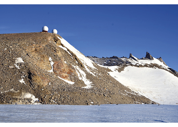
Figure 7.3 Troll, in Queen Maud Land
Source Kjell Arne Aarmo
The Antarctic Treaty of 1 December 1959 establishes certain activity restrictions on the continent that may have implications for space activities. The treaty mentions specifically that Antarctica is to be used only for peaceful purposes, and is to be a demilitarized area. As a consequence of the treaty’s environmental protocol, which came into force in 1998, Norway is under strict obligation to take measures to protect the environment in the course of its activities in the Antarctic. All states operating in Antarctica are subject to the right of other states to inspect their installations and bases.
Mainland Norway
On the mainland there are a number of different types of ground infrastructure related to controlling and receiving signals from satellites, sensors and smaller stations as well as basic research infrastructure related to space.
The Tromsø Satellite Station is owned and operated by KSAT. Its antenna array serves satellite owners from many countries and organisations on a commercial basis. (KSAT is discussed more fully in Chapter 8.) Nittedal Teleport is Telenor’s main control station for communication satellites in the Thor family and for communication channels that Telenor controls on other satellites. The Eik earth station in Rogaland is operated by Astrium Services, of France, and relays broadband traffic to and from maritime parties. The Norwegian Meteorological Institute in Oslo has some antennas of its own for direct access to data from European and US weather satellites.
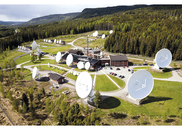
Figure 7.4 Nittedal Teleport earth station
Source Telenor Satellite Broadcasting (TSBc)
The Andøya Rocket Range (ARR) is a centre for the launch of research rockets and the release of scientific balloons. The rocket range is situated by the ocean, and rockets can be made to splash down in remote, unoccupied waters. In the mountains above the rocket range is ALOMAR, which conducts research on atmospheric conditions and assists with the launch of sounding rockets. (ARR is more fully discussed in Chapter 8.) Notable infrastructure elsewhere on the Norwegian mainland includes reference stations in Kirkenes, Tromsø and Trondheim to serve the EU’s EGNOS system. The Norwegian Coastal Administration has 12 stations along the Norwegian coast for differential GPS enhancement.
The Tromsø Geophysical Observatory (TGO) operates a magnetometer network consisting of 14 instruments positioned around Norway, including Svalbard. Magnetometers monitor geomagnetism by measuring the strength and direction of the earth’s magnetic field around the instruments. The measurement data have many different applications, from earthquake research to aurora forecasting and navigation for subsea oil drilling.