2 The climate and climate change in Norway
2.1 The present climate and historical climate variability
Norway’s long coastline and extensive mountain ranges make the country vulnerable to the forces of nature. There has always been considerable climate variability in Norway, and the climate has important consequences for society. The climate is milder in Norway than in other areas at the same latitude, mainly because the Gulf Stream transports warm water northwards along the Norwegian coast. Prevailing south-westerly winds carry warm, moist air towards the coast, particularly in winter, when low pressure systems are normally a common phenomenon. However, Norway can also experience cold, dry winters, as it did for example in 1995–96 and 2009–10.
Textbox 2.1 The North Atlantic Oscillation (NAO) has a strong influence on Norway’s weather
The weather in Norway varies considerably from year to year. Whether the winters are mild and stormy or relatively cold and dry is linked to natural variability in the atmospheric circulation over the North Atlantic. This pattern of variability is known as the North Atlantic Oscillation (NAO), and is an important factor behind the wide natural fluctuations from year to year in wind, temperature and precipitation throughout mainland Norway.
Measurements of temperature, precipitation and wind show wide variation between years and between decades. This is mainly due to natural variability in the climate system. To see how the climate changes over time, it is necessary to define reference periods. These are internationally defined 30-year periods for calculating climate «normals». The current climate normal period is 1961–90. Discussions of how much the climate has changed are often based on temperature, precipitation and wind data for this period.
Textbox 2.2 Natural climate variability since the last Ice Age
After the end of the last Ice Age a little more than 11 000 years ago, there was a warm period in Norway when summer temperatures were probably 1.5–2 °C higher than the normal for 1961–90. This allowed pine trees to grow on parts of the Hardangervidda mountain plateau that are now above the treeline. There were also periods during the Middle Ages when Scandinavia had a generally mild climate, which allowed people to settle in Greenland. During the Little Ice Age in the mid-1700s, most Norwegian glaciers advanced to their greatest extent for several thousand years. The warm period during the Stone Age was caused by variations in the position of the Earth relative to the Sun. The warm period during the Middle Ages and the cold period a little less than 300 years ago were probably related to variability in solar activity and the frequency of major volcanic eruptions. Much of the natural climate variability is apparent at the regional rather than the global scale. For example, the warm medieval period was most marked at northern latitudes, while the tropics were probably not much warmer than they are today.
Precise observations of temperature and precipitation from all parts of Norway are available from the late 1800s onwards. On the basis of these observations, we can conclude that mainland Norway has warmed by about 0.8 °C in the past 100 years, which is in line with the rise in global mean temperature in the same period. The greatest rise in temperature has taken place in the most recent decades. Since the normal period 1961–90, the growing season has become one to two weeks longer in most parts of Norway. The areas that experience hot days, defined as days when the daily mean temperature is above 20 °C, have expanded considerably.
Norway’s climate is also wetter than it used to be. Annual precipitation has risen by about 20 % since 1900, with the steepest rise after 1980. Over the most recent 20 years, there have only been four years when annual precipitation was lower than the normal value for 1961–90, whereas in the first 20 years of the period (1900–20) there was not a single year when annual precipitation was higher than the current normal level. Precipitation has risen most in winter, by about 17 % relative to 1961–90. In the wettest parts of Western Norway, winter precipitation has risen by 25 % in the same period.
2.2 The climate of the future – climate projections for 2050–2100
Climate models are used as a basis for computing projections of how temperature, precipitation and wind may change towards the end of this century. The model simulations include a number of different values for model variables and a range of other assumptions. The results of the simulations are analysed and used as a basis for projections. The projections that are presented below are based on a compilation of a large number of different projections and a combination of different scenarios for global greenhouse gas emissions.1
Temperature
All climate projections indicate that the climate will become warmer in all parts of Norway and in all seasons during this century. It is estimated that the annual mean temperature in Norway will rise by 2.3–4.6 °C towards the end of the century relative to the value for the normal period 1961–90. The temperature rise will be largest in inland areas, North Norway and Svalbard. There is considerable uncertainty associated with such projections, and the temperature changes may be either larger or smaller than the interval quoted here.
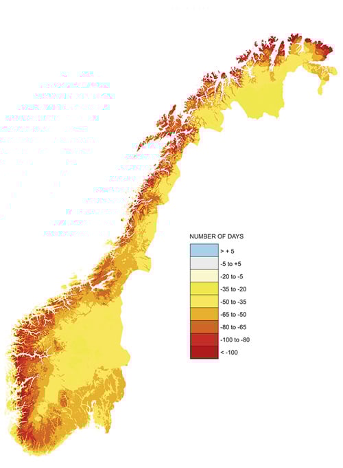
Figure 2.1 Map showing projected changes in the number of days of snow cover in Norway, 2071–21001
1 Example of a projection based on emissions scenario B2 (IPCC, SRES B2, medium global growth in emissions) and the global climate model ECHAM/MPI (relative to the normal period 1961–90).
Source Norwegian Water Resources and Energy Directorate and Norwegian Meteorological Institute, 2013
Growing season, snow cover, glaciers
The growing season in Norway, defined as the number of days when the mean temperature is above 5 °C, is expected to become considerably longer during this century. Projections show an increase of one to two months in much of the country and two to three months in some upland areas.
The duration of snow cover will decrease throughout Norway up to 2100. Figure 2.2 shows that the greatest changes are expected in low-lying areas, where some projections indicate that the length of the snow season will decline by two to three months. This means that there will be many years with hardly any snow in the lowlands, but still certain years with considerable amounts of snow. In the mountains and inland parts of Finnmark county, the average maximum snow depth may increase until mid-century as a result of higher winter precipitation, and thereafter decline.
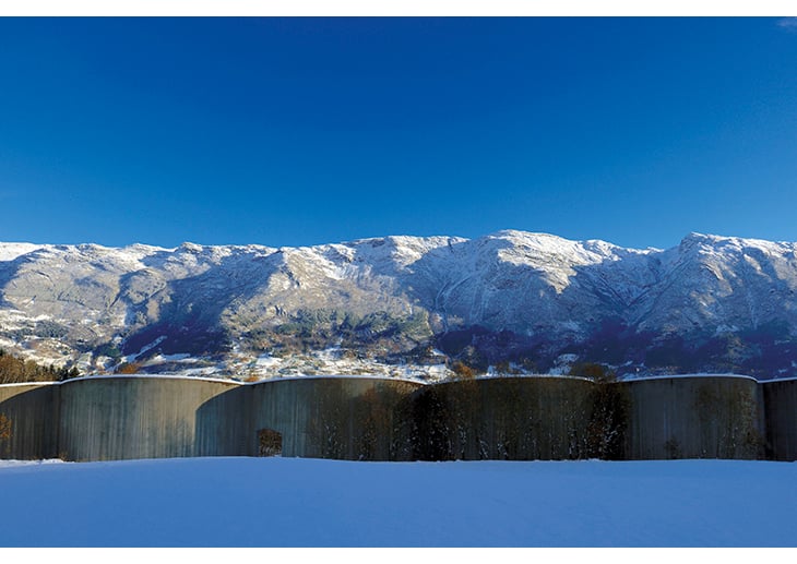
Figure 2.2 Concrete avalanche defence, Hardanger municipality
Photo: Stig Tronvold/Samfoto/NTBscanpix
Glaciers fluctuate in size because of variability in summer temperatures and winter precipitation. Inland glaciers in Norway, for example in the Jotunheimen mountains, will probably continue to retreat as summer temperatures rise. Trends for coastal glaciers are driven more by changes in winter precipitation, and they will continue to advance as long as snowfall in winter exceeds ice melt in summer. By 2100, more than 90 % of all Norwegian mainland glaciers may have disappeared, and the total area of glaciers may have declined by 30–40 %. These figures are based on mean values for temperature projections.
Precipitation
Annual precipitation for the country as a whole is expected to rise. Projections indicate a rise of 5–30 % in annual mean precipitation by 2100 relative to the period 1961–90. The mean projections for Norway as a whole indicate a rise of about 20 % in autumn, winter and spring, and about 10 % in summer. Mean projections for different regions indicate that autumn precipitation will rise by more than 25 % in all coastal areas from the southernmost tip of Norway to western Finnmark. They also indicate a 25 % increase in winter precipitation in Eastern Norway and inland areas of Nord-Trøndelag and Sør-Trøndelag counties. Summer rainfall in Eastern and Southern Norway may decrease somewhat, while it may increase by about 20 % in Nordland county.
There are large differences between the upper and lower limits of the range of precipitation projections throughout the country. The mean projection indicates a trend close to that observed during the 20th century, while the high projection is closer to the trend we have observed over the past 20–30 years. In many areas, the high projection indicates a rise of more than 50 % in autumn, winter or spring precipitation.
The projections show that the number of days of heavy precipitation will rise during this century, and that the amount of precipitation that falls on such days may also rise. This applies to all seasons and all regions. The models do not provide enough detail for calculations relating to heavy showers, but the results nevertheless indicate that the frequency of heavy rain showers may rise in the future. This may increase the risk of thunderstorms and lightning strikes.
Drought
Higher temperatures, increased evaporation and the possibility of lower rainfall in summer may result in longer periods of low flow in rivers, and soil moisture and groundwater deficit. This may in the longer term lead to problems with drinking water supplies and agriculture in certain parts of Norway. Summer droughts may increase the need for irrigation and the risk of forest fires.
Flooding
Changes in precipitation and temperature patterns will also result in changes in flooding patterns in Norway. With higher temperatures, spring floods will occur earlier, while lower snowfall will result in smaller snowmelt floods in the larger rivers. When more precipitation falls in the form of rain instead of snow, flooding in late autumn and winter may become more frequent. In those parts of the country where the largest floods are caused by rain, floods will become more severe. More frequent intense rainfall may cause particular problems in small, fast-flowing rivers and streams and in urban areas.
Landslides and avalanches
There are many different types of landslides and avalanches, and the causal relationships between these events and climate change are more complex than those between flooding and landslides and avalanches. However, there is a clear link between precipitation, temperature and wind conditions, and different types of avalanches. Higher temperatures will reduce the risk of dry snow avalanches at altitudes below 500–1000 metres, but may increase the risk of wet snow avalanches and slush flows. A higher frequency of intense precipitation events may also increase the risk of landslides and flood-related debris flows. Quick clay slides can also be triggered by prolonged intense rainfall and river erosion, although in most cases they are triggered by human activity. Changes in precipitation patterns may also increase the risk of landslides and avalanches in areas that have not suffered from them previously.
Wind
Climate models show little or no change in average wind conditions in Norway up to 2100. However, there are indications that high wind speeds may become more frequent.
Waves
A few studies have been conducted of future wave conditions based on selected climate projections. These show relatively small changes along the Norwegian coast, with the exception of the North Sea and Skagerrak. Here, it is estimated that the significant wave height of the most extreme waves will increase by 6–8 %. Because of systematic weaknesses in the models, it is not yet possible to draw any conclusions about how wave conditions may change in the Barents Sea.
Sea temperature
There have only been a limited number of studies involving modelling of changes in sea temperature in Norwegian waters. It has been estimated that the annual mean temperature of the North Sea may rise by 1.5–2 °C.
Ocean acidification
Since the beginning of the industrial era, the oceans have absorbed about 40 % of the CO2 emissions from fossil fuel consumption and cement production. This is making the world’s seas more acidic. The rate of acidification varies from one part of the world to another, and is more rapid at high latitudes, because CO2 dissolves more readily in cold water. The current global climate models show that acidification is most rapid where seawater temperatures are lowest, i.e. in the polar regions.
Acidification is a direct result of the higher atmospheric concentration of CO2, and is taking place independently of the greenhouse effect and global warming. Changes in circulation patterns in the oceans and atmosphere, and stratification in the oceans, influence uptake of CO2 in seawater and the degree of acidification in different areas.
The pace of ocean acidification is closely related to trends in CO2 emissions to the atmosphere. Studies show that in Norwegian waters, pH can be expected to drop by more than 0.5 units by the end of this century. The chemical processes that result in acidification are clearly understood, but less is known about what impacts acidification will have on marine ecosystems.
Sea-level rise
Global sea level has risen by about 17 cm in the past 100 years. In a longer perspective, global sea level has risen by 120 metres since the last glacial maximum about 20 000 years ago, but has been more or less stable for the past 4 000 to 5 000 years. Despite this, most of the Norwegian coast has experienced a net drop in sea level since the last Ice Age. This is because the land surface has been rising considerably after the Fennoscandian ice sheet melted around 11 500 years ago, so that the crust was no longer depressed by the weight of the ice and could slowly rebound.
Global mean sea level is now rising by about 3 mm per year. In its Fourth Assessment Report, the Intergovernmental Panel on Climate Change (IPCC) presented 18–56 cm as a possible range of global average sea rise up to 2100. However, these figures do not capture the full effect of melting of the major ice sheets on land. This is a weakness of the underlying data, particularly since more recent studies show that the Greenland ice sheet seems to be melting more rapidly than previously assumed. The estimates of sea-level rise up to 2100 are very uncertain, primarily because it is uncertain how rapidly glaciers and the large ice sheets in Greenland and Western Antarctica are likely to melt.
Footnotes
I. Hanssen-Bauer, H. Drange, E.J. Førland, L.A. Roald, K.Y. Børsheim, H. Hisdal, D. Lawrence, A. Nesje, S. Sandven, A. Sorteberg, S. Sundby, K. Vasskog and B. Ådlandsvik (2009) Klima i Norge 2100. Bakgrunnsmateriale til NOU Klimatilpassing, Norsk klimasenter, September 2009, Oslo. (The Climate in Norway in 2100. Background material for Official Norwegian Report on climate change adaptation. In Norwegian only.)