11 Sea and air – transport, safety, rescue and emergency response system
11.1 Introduction
As described in Chap. 2 the High North and Svalbard are among the areas in the world that are most affected by climate change. At the same time, the areas are generally characterised by increased activity. The trend in recent years shows that ship traffic to the Arctic areas is increasing. A reduction in the extent of the sea-ice will make the area more accessible to passage by sea and other activities. For Svalbard this pertains especially to cruise tourism and other ship traffic.
As a consequence of a warmer ocean the range of major fish stocks may change. The range of many species is expected to move to the north and east. Indications that this is happening have already been seen. Trawling for cod is moving steadily northward and now takes place as far north as Isfjord (78 degrees north). There is also considerable reloading of fish by Bjørnøya. In the longer term, an increasingly ice-free Arctic Ocean may open completely new routes to international shipping between east and west. The shortest route through the Arctic Ocean from the major shipping ports on the European continent passes directly west of Svalbard. Major commercial and industrial activities in the Arctic Ocean could increase the importance of Svalbard to rescue and emergency response systems and provision of maritime services. The unique opportunities for downloading data from satellites also indicate that Longyearbyen can be an important platform for monitoring ship traffic in the Arctic basin.
As described earlier in the report, ship traffic to Svalbard has increased considerably in the last 10 years. Research-related voyages have also increased. This must be viewed in light of the fact that Svalbard has become a key area for obtaining knowledge about what happens when temperatures in the Arctic rise and how this may impact the climate in other places on Earth. This growth can be expected to continue, both as a result of increased tourism and population growth in Svalbard and because the interest in field-based research and the use of Svalbard as a meeting place is on the rise. In the aggregate this requires greater attention from the authorities so that the quality of safety and rescue systems at sea, in the air and on land is proportional to the level of activity.
11.2 Sea transport and safety at sea
The previous Report to the Storting on Svalbard, Report No. 9 (1999 – 2000) to the Storting, describes increasing sea transport in the archipelago, a change that has continued in recent years. The report furthermore stated that because marine charting was incomplete, and navigation aids few and far between in the waters around Svalbard, there was a particular risk of sea traffic accidents in the area. In addition, the legislation and administrative authority differed in certain areas from the mainland, and, with the exception of the Seaworthiness Act which applied only to Norwegian ships, neither the Harbour Act, the Pilotage Act nor other shipping legislation applied to the archipelago.
Since then the Interministerial Committee on Polar Affairs has highlighted safety at sea in the waters surrounding Svalbard, with recommendations on measures followed up by specific actions. The Harbour Act was applied to Svalbard effective 1 May 2008. This established the same legal framework in Svalbard as on the mainland for regulating and facilitating safe sea traffic. The application of the Harbour Act in Svalbard has been followed up by the Norwegian Coastal Administration, which has laid down regulations for arrival and departure reports for Svalbard, particularly regulations concerning vessel reporting obligations and sailing rules for the approach to Svea. An obligatory local guide service is being evaluated.
In addition to increased sea traffic in the waters around Svalbard, we see increased activities in the northern areas in general, on both on the Norwegian and Russian sides. This activity will also have an impact on safety at sea in Svalbard, and poses further challenges to Norwegian administration that will have to be met by preventive measures.
Despite the fact that a number of the measures proposed in the previous Report to the Storting on Svalbard have been initiated, developments in both Svalbard and the northern areas require maritime safety in the waters around the archipelago to be subjected to thorough evaluation and for measures to be initiated where they are required.
The goal of the Government is to reduce the risk of undesired incidents during sea transport to Svalbard, so that damage to life, health and the environment can be avoided. Preventive measures are clearly the most important. As for the mainland, key maritime safety measures in Svalbard are the establishment and operation of maritime infrastructure and services, and requirements for and supervision of the design of ships and crew qualifications. In addition, requirements for fuel quality are important for limiting the potential for damage to the environment if an accident were to occur.
Sea transport is an international industry. The International Maritime Organization (IMO), a UN agency, develops international rules for shipping. International rules lay down important parameters for Norway’s regulation of sea transport. The trend is toward increasingly stricter environmental and safety requirements. Regardless of where a vessel is it is subject to general requirements for ships and crews pursuant to international rules. By means of inspections and supervision the flag state is obliged to ensure that its own ships comply with the rules. In addition, foreign ships calling at Norwegian ports are inspected (port state control).
11.2.1 Status and risks
Maritime safety measures implemented in Svalbard in recent years have brought the level of safety closer to that along the mainland coast. However, the local and climatic conditions in the archipelago indicate that many conditions should be subject to special evaluation with a view to implementation of further measures.
Compared with the mainland, traffic density in Svalbard is modest. Svalbard consists to a large degree of particularly vulnerable natural areas worthy of protection. The overall potential for damage in Svalbard is therefore large, while the acceptance of the risk of environmental damage is similarly low. Acute oil spills from shipping are some of the incidents with the biggest potential for considerable and long-term damage to the natural environment. Due to the special conditions prevailing in Svalbard waters, the lack of marine charting and few navigation aids, the biggest risk of accidents is related to groundings and associated danger of oil spills. The risk is the biggest in the coastal waters where it does not take long before a spill reaches land. Preventive maritime safety measures are essential in the archipelago to prevent ship accidents with potentially huge consequences for life, health and the environment.
The low traffic density in Svalbard means that the probability of spills is also relatively low. In addition, the potential spill volume is smaller than along the coast of the mainland as a result of the absence of large oil tankers. The risk that large areas can be affected by spills is therefore similarly smaller. The amount of bunkers spilled in the event of an accident can still be considerable. The Arctic environment is generally vulnerable, and the lifetime of oil in Arctic waters is long. A spill can therefore impact the environment for a long time. Svalbard also has major concentrations of vulnerable biological resources gathered in small geographic areas. This increases the risk of considerable damage even with smaller spills, and major acute spills will in most cases affect adjacent protected areas.
The response time for taking action after an acute spill will be long in most places in Svalbard, depending on the distance to local oil spill protection equipment and vessels that have oil spill protection equipment permanently on board. On the east coast of Svalbard the response time will most likely be one to two days. Oil spills can therefore spread over large areas before oil pollution measures can be implemented.
Spills of heavy bunker oil will cause far greater and more long-lasting consequences than spills of light marine diesel, which disappear quickly from the surface due to evaporation and mixing with water. Use of light bunker oil will therefore provide a clear benefit for the emergency response to acute pollution. This applies both with respect to the scope of an action, and the consequences for the environment compared with a similar spill of heavy types of fuel. Fuel quality requirements will contribute to limiting the potential damage of acute spills. This has also meant the remaining environmental risk is largely linked to shipping of coal and other utility traffic to and from the settlements, see section 11.2.7.
Sailing in Svalbard represents special challenges in relation to the mainland, and navigation conditions around the archipelago are demanding. The accumulated knowledge of the waters and expertise of navigators that have sailed in the waters by Svalbard for many years represent an important contribution to reducing the risk of maritime accidents. On the other hand, an increase of ship traffic, with new players, will increase the risk of accidents if risk-reducing measures are not implemented.
Future challenges relate to many factors. Weather and ice conditions can change quickly, causing the waters along the coast to change. One challenge of retreating ice is that it exposes new sea areas that have not been surveyed but are tempting to put to use. Around half of the coastal waters around Svalbard, mainly the west and northwest coast, have been hydrographically surveyed using modern methods. This means that the current maps are inadequate. Navigation in poorly charted sea areas is associated with a higher risk than navigation in areas that are well mapped. Areas with reduced risks cause reduced safety for those sailing in the waters around Svalbard.
For 2008, 751 km2, as shown in Figure 11.1, was surveyed. The pink areas show where hydrographic surveys are planned in coming years.
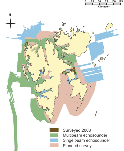
Figure 11.1 Sea surveying at Svalbard. Status and planned surveys.
Source Norwegian Mapping Authority
Furthermore, there is limited infrastructure for actions in the event of accidents and challenges in relation to the long distances in the archipelago relating, e.g., to the number of depots, suitable emergency ports and available towing vessels. This can mean that such accidents will have greater negative consequences for human life and the environment compared with similar situations on the mainland.
The biggest environmental risk relates to bunker spills. In addition to the time and place, the consequences will depend on the quality of the bunkers, and how much is spilled. As on the mainland it is important that maritime safety measures are based on analyses, indicators and continuous monitoring of risk development in the area. Good contact is also desirable among affected parties operating in the area to ensure common understanding of the challenges.
11.2.2 Traffic basis
Ship traffic around Svalbard consists of overseas cruise traffic, expedition vessels, goods traffic, research-related shipping and fishing activities on the coast and in certain fjords. While the number of ship calls in Svalbard has been stable in recent years, we see an increase in the number of passengers. An increase in research vessel traffic is expected. Here, both the number of voyages and tonnage are increasing. The overseas cruise vessels have few calls, typically 1 – 3 disembarking sites. Though Svalbard is a small part of their voyage, some of the vessels call at Svalbard several times during the season.
The Norwegian Coastal Administration will survey the traffic basis of the archipelago with a view to any measures that can strengthen safety at sea.
Expedition cruise vessels usually start and end their tours in Longyearbyen. They sail along large parts of Svalbard and have far more disembarkations than the large overseas ships.
With respect to coal shipping from Sveagruva, there has been an increase from 14 ships in 1998 to 64 in 2007, while a decline has been registered in the number of fishing vessels, particularly the number of vessels fishing for shrimp.
Ship traffic to Barentsburg consists mainly of vessels that ship out coal, small cargo ships and tankers, and calls by cruise vessels. Like other ports of call in Svalbard, Ny-Ålesund has also noted an increase in ship traffic.
The Norwegian Coastal Administration will survey the overseas cruise traffic with a view to any measures that can strengthen safety at sea.
11.2.3 Relevant legislation
The Harbour Act and underlying regulations were applied to Svalbard effective 1 May 2008 by Regulations No. 342 of 11 April 2008 concerning harbours and fairways in Svalbard. Necessary local adjustments for the archipelago are contained in the regulations.
The main reasons for extending the Harbour Act to Svalbard are to strengthen maritime safety and improve opportunities to organise port operations in Svalbard. With the increasing sea transport it has been necessary to put in place appropriate rules for facilitating traffic. Furthermore, bolstered safety at sea will be an important contribution for protecting the vulnerable environment in the archipelago.
Table 11.1 Ship traffic to Longyearbyen 2001 – 2008
| Number of calls (tourism) | 2000 | 2001 | 2002 | 2003 | 2004 | 2005 | 2006 | 2007 | 2008 |
|---|---|---|---|---|---|---|---|---|---|
| Cruise ships, overseas | 23 | 27 | 29 | 42 | 32 | 50 | 40 | 53 | 49 |
| Tourist boats | 9 | 73 | 259 | 291 | 257 | 457 | 439 | 134 | 177 |
| Day trip boats | 268 | 250 | |||||||
| Pleasure craft | 46 | 41 | 57 | 61 | 85 | 64 | 71 | 44 | 74 |
| Total number of calls | 78 | 141 | 345 | 394 | 374 | 571 | 550 | 499 | 550 |
| Cargo ships | 5 | 11 | 29 | 19 | 20 | 57 | 78 | 62 | 54 |
| Educational/research | 28 | 47 | 47 | 23 | 51 | 64 | 69 | 41 | |
| Fishing vessels | 50 | 51 | 43 | 27 | 20 | 25 | 27 | 17 | 21 |
| Navy/Coast Guard | 5 | 11 | 17 | 26 | 20 | 41 | 32 | 34 | 34 |
| Polar-/Nordsyssel | 14 | 24 | 25 | 25 | 39 | 36 | 48 | 55 | |
| Other vessels | 69 | 8 | 11 | 12 | 15 | 16 | |||
| Total number of calls (other) | 88 | 134 | 160 | 166 | 116 | 224 | 249 | 245 | 221 |
| Total number of calls | 166 | 275 | 505 | 560 | 490 | 795 | 799 | 744 | 771 |
| Layover days | |||||||||
| Cruise ships | 17.0 | 19.5 | 16.5 | 17.2 | 20.9 | 15.5 | 25.8 | 31.5 | |
| Tourist boats | 366.0 | 320.0 | 381.5 | 393.5 | 379.5 | 326.3 | 201.6 | 138.0 | |
| Day trip boats | - | - | - | - | - | - | - | 152.2 | 135 |
| Pleasure craft | 133.0 | 142.0 | 192.0 | 220.0 | 193.0 | 172.0 | 129.0 | 240.0 | |
| Total number of layover days | 516.0 | 481.5 | 590.0 | 579.0 | 630.7 | 593.4 | 513.8 | 508.6 | 544.5 |
| Passengers | |||||||||
| Day trip boats | - | - | - | - | - | - | - | 8168 | 8823 |
| Tourist boats | 7,425 | 8,058 | 8,190 | 8,585 | 8,707 | 10,508 | 13,761 | 2,824 | 7,342 |
| Cruise ships | 8,474 | 10,870 | 10,567 | 14,375 | 13,130 | 17,874 | 23,324 | 20,764 | 22,404 |
| Total number of passengers | 15,899 | 18,928 | 18,757 | 22,960 | 21,837 | 28,382 | 37,085 | 31,756 | 38,569 |
Source Bydrift Longyearbyen
The application of the Act establishes a system and rules similar to those on the mainland. Via the Norwegian Coastal Administration, the Ministry of Fisheries and Coastal Affairs is responsible for administering the fairways and is authorised to stipulate specific fairway measures including traffic and speed restrictions and tugboat requirements. Longyearbyen port has been given formal authority to improve the facilitation of the traffic and ease the passage of vessels in the port.
Via the Norwegian Coastal Administration the Ministry of Fisheries and Coastal Affairs has been given the overriding responsibility for the lighthouse and buoy service, and will review the structure of the shipping lanes to give recommendations on better marking and mandatory traffic lanes. As previously, the Norwegian Polar Institute will undertake the practical deployment of beacons and buoys, now by agreement with the Norwegian Coastal Administration.
In recent years the number of navigational installations has increased and improved the marking of the approach to Kapp Amsterdam at Sveagruva. There is still a need to improve navigation instructions for this fairway. There is also a need for further installations due to the steadily increasing traffic around the entire archipelago.
To assess this in greater detail, the Norwegian Coastal Administration will proceed in 2009 on a risk-based review of the navigation infrastructure in Svalbard.
Act No. 9 of 16 February 2007 on ship safety (Ship Safety Act) entered into force on 1 July 2007. For Norwegian ships the law will be applied regardless of where they are, including Svalbard and Jan Mayen.
The Ship Safety Act replaced the Seaworthiness Act, which applied to Norwegian ships regardless of location. The King was also authorised to apply all or parts of the Act to foreign ships and foreign installations, including in the territorial waters of Svalbard. However, that was not done and ordinary port state control for foreign ships calling at Svalbard was not performed as is the case for foreign ships arriving in Norwegian ports on the mainland.
On the other hand, the new Ship Safety Act, with an extensive body of regulations has been applied to Norwegian territorial waters of Svalbard, with certain adjustments. This means that the legislation also applies to foreign ships. Under the rules, the authority to perform port state control of foreign ships has been assigned to the Maritime Directorate. The entry into force of the Ship Safety Act is part of the follow-up of the recommendations of the working group appointed by the Committee on Polar Affairs in September 2004 (the shipping group), and is an important contribution to strengthening maritime safety in Svalbard.
11.2.4 Monitoring and reporting
Monitoring of traffic is an important contribution to ensuring safe passage at sea. There is a reporting obligation through SafeSeaNet (SSN) for vessels above a certain tonnage limit or minimum length, with a certain amount of bunkers on board, and for all vessels carrying hazardous or contaminated cargo. Vardø VTS is responsible for monitoring the traffic around Svalbard. Today, AIS receivers are located only on Bjørnøya, in Isfjord, at Adventneset by Longyearbyen and at Sveagruva. The AIS receiver on Bjørnøya belongs to the Norwegian Coastal Administration, while the receiver in Isfjord and Longyearbyen belongs to Bydrift Longyearbyen. With respect to Sveagruva the Norwegian Coastal Administration initiated a trial project with the installation of a single AIS receiver, while operations are carried out according to a cooperation agreement between the Norwegian Coastal Administration and Store Norske Spitsbergen Kulkompani. Due to the fact that the Norwegian Coastal Administration does not have the same access to monitoring data in Svalbard as it does on the mainland, special regulations have been issued on position reporting for vessels in the waters of Svalbard.
A sufficient overview of ship traffic to Svalbard requires data from several sources. Real-time data is necessary for providing an understanding of the situation that makes it possible to respond quickly and efficiently in the event of incidents and accidents. This is best achieved by building a land-based AIS chain along the busiest fairways to the archipelago. The Government will consider establishing such a system in Svalbard. However, to achieve a total overview of ship traffic in the area, it is necessary to have data from the satellite-based AIS receivers or LRIT (Long Range Identification and Tracking), which the IMO has decided to establish. LRIT is a global civilian satellite-based system for identification and tracking of vessels. Norwegian authorities will follow up the international work on developing LRIT and ensure sound national implementation. The system is expected to be introduced in Norway in 2009, and will have a major impact on maritime safety in Svalbard. Further development of AIS via satellite will have a similar impact.
11.2.5 Local guide service
One measure that is being considered to strengthen maritime safety in the waters surrounding Svalbard is the formal establishment of a local guide service, i.e. an obligation to use a local guide while sailing in the waters around Svalbard. The term local guide means people with long experience and satisfactory knowledge of navigation.
Today, two forms of local guide services exist in Svalbard. One of the forms is used in connection with arrivals and departures at the coal terminal at Sveagruva. Today, the use of local guides is a condition for the Governor’s permission to engage in coal shipping. The other form of local guide service is practised in connection with overseas cruise traffic. This is an informal and voluntary arrangement offered by private individuals. At the request of the Ministry of Fisheries and Coastal Affairs the Norwegian Coastal Administration has initiated a project to study the possibility of establishing a mandatory local guide service. Work is now taking place on further specification of the contents of such a service and the vessels covered by the scheme. When the necessary clarifications have been made, the draft regulations will be presented to the Committee on Polar Affairs before being circulated for comment.
11.2.6 Fuel quality requirements
In 2007 the Government introduced a requirement that ships that call at nature reserves in eastern Svalbard shall not carry or use fuel other than light marine diesel (DMA). The purpose of this requirement is to limit potential damage in the event of acute spills within the nature reserves, where the acceptance of risk is particularly low. A proposal for a similar fuel quality requirement for ships that sail within the three large national parks on the west side of Svalbard has recently been circulated for comment.
The proposal includes necessary exceptions for utility traffic to and from the settlements and a time-limited exception for sailing into Magdalenefjord, which makes it possible for the cruise industry to adjust to the new fuel quality requirement.
With these requirements in place the remaining environmental risk will largely be connected with shipping of coal and other utility traffic to and from the settlements. Ship traffic to and from Svea through Bellsund and Van Mijenfjord represents a special risk to the environment because ships loaded with heavy bunker oil pass through challenging waters, where the potential damage from an acute oil spill is huge. Most of the area that will be affected by any spill has national park status. This indicates that the acceptance of risk must be low. Even if requirements the Governor has laid down for coal shipping together with the new sailing provisions for the waters in Bellsund and Van Mijenfjord help reduce the risk, the potential damage from a spill in the approach to Svea will still be large. Further measures to reduce the potential damage and risk of pollution in this area will be assessed.
11.2.7 Preparedness against acute pollution
Preparedness against acute pollution is an important damage-reducing measure. The formal basis for contingency planning and taking action against acute oil pollution is contained in the Svalbard Environmental Protection Act. Under Section 70 the Act states that any person engaged in an activity in Svalbard is required to prevent acute pollution and ensure measures if pollution has occurred to limit its impact. The emergency response requirements of activities in Svalbard are laid down by the Norwegian Pollution Control Authority.
In the event of acute spills of oil in Svalbard the person responsible for the spill will be responsible for cleaning it up. This is done under the supervision of the Norwegian Coastal Administration, which can delegate its authority to the Governor of Svalbard.
The Norwegian Coastal Administration is responsible for the state emergency response to acute pollution in Svalbard both within and outside 12 nautical miles from the base line (mean low water mark). Within 12 nautical miles the Governor of Svalbard is responsible for operations while the Norwegian Coastal Administration may also take charge of actions within 12 nautical miles. Outside 12 nautical miles the Governor of Svalbard is obliged to take action until the Norwegian Coastal Administration takes charge of the action. Responsibilities and tasks in Svalbard are regulated in a separate agreement.
The biggest challenge for the emergency response system in Svalbard is the climatic and geographic conditions, which put health, safety and the environment at particularly great risk. Ship traffic in the waters surrounding the archipelago takes place mainly during the summer months when the climatic conditions are as a rule the best. An action to limit the damaging effects of an acute spill presents challenges both to personnel and equipment. It is likely that any action against acute pollution will have to be interrupted for long periods as a result of ice, darkness, strong winds and cold. Cargo traffic mainly goes to Longyearbyen, Sveagruva, Ny-Ålesund and Barentsburg. Any action far from the settlements will also involve major challenges in connection with necessary logistics.
The need for emergency response equipment and the amount of it is calculated on the basis of the risk that exists for acute spills. The equipment that private enterprises use to deal with acute pollution is mostly gathered in Svea, and will handle the risk of activities in Svea and the fairway out of Akselsundet.
The responsibility of the Norwegian Coastal Administration for the state emergency response equipment in Svalbard involves procurement of equipment, maintenance and upgrading if necessary. In cooperation with the Governor of Svalbard the Norwegian Coastal Administration has established an emergency response depot in Longyearbyen, and some of the emergency response equipment has been moved to Ny-Ålesund. In contrast to the state depots on the mainland the depot crews in Svalbard are employed by enterprises in Svalbard. The Governor of Svalbard has signed agreements with various players concerning the provision of crews for the depot force. In exchange they are provided access to the equipment at the state depot in Longyearbyen. The agreements ensure crews to handle Norwegian Coastal Administration equipment at the depot in Longyearbyen in case acute oil pollution occurs. Under the agreement the crews are to be capable of participating in the action for up to 10 days.
Of other state resources in Svalbard the presence of the Coast Guard is important for preventing accidents and for actions to clean up acute pollution.
11.2.8 Handling ballast water
As a result of ship traffic the last decade has seen an increase in the spread of species to sea areas. This could represent a serious environmental threat because ecosystems become imbalanced and species stand the risk of extinction. Climate change and an increase in ocean temperatures along the west coast of Svalbard will likely increase the chance of non-native species becoming established here. In particular, there are risks associated with the intake and discharge of ballast water from ships in international traffic.
In 2004, the International Maritime Organization (IMO) adopted a convention on managing ballast water, but it has yet to enter into force. Nevertheless, the Government has decided to design a national set of rules in line with the requirements of the convention. Draft regulations on ballast water were circulated in the autumn of 2008. Under the regulations all ships in the Norwegian Economic Zone or territorial waters that have taken in ballast water outside specified areas shall manage the ballast water by cleaning, replacement or delivery to reception depots. In the event of replacement the ballast water shall be replaced in areas lying in principle 200 or, alternatively, 50 nautical miles from the coast at ocean depths of more than 200 meters. Specifically defined replacement areas along the Norwegian coast are also listed. The regulations apply to Norwegian territorial waters, including the territorial waters around Svalbard and Jan Mayen, and in the Norwegian Economic Zone. The changes are expected to go into effect by the summer of 2009. Norway will then be one of the first countries in the world to adopt requirements for handling ballast water. This will help reduce the risk of introductions of non-native species in Svalbard too.
11.2.9 Evaluations
Together with greater activity in the High North, an increase in sea transport in the waters around Svalbard poses new challenges to maritime safety efforts around Svalbard. The increasing traffic must primarily be met by preventive measures that reduce the likelihood of accidents and that limit the impacts if accidents occur. Several measures have consequently been initiated to deal with the increased activities, and further measures have been evaluated to improve maritime safety in Svalbard.
The trend shows that ship traffic to the Arctic areas is increasing, at the same time as the Arctic sea-ice is being affected by climate change. This makes a continued increase of ship traffic likely, increasing the probability of a ship accident occurring.
Going forward, a key challenge will therefore be to adequately monitor changes in ship traffic. Adequate monitoring will provide ample opportunities to analyse any trends, so that necessary measures such as regulations and development of maritime infrastructure, services and emergency preparedness can be carried out. The combination of these contributions will be important for keeping the ocean area around Svalbard as clean and rich as possible. To implement good analyses about risk development and traffic development, reliable background information about the activities must be obtained. AIS and LRIT will be key sensors for obtaining this type of information. Analyses will secure a good foundation for implementing effective measures and for subsequently checking whether the measures have had the desired effect.
The Arctic Council recently presented an Oil and Gas Assessment – OGA report illuminating future challenges relating to oil and gas activities in the Arctic. Entitled the “Arctic Marine Shipping Assessment – AMSA”, the report was presented to the ministerial meeting of the Arctic Council in Tromsø in April 2009. Both of these reports describe the future challenges in the area.
11.3 Air transport – background and development
Svalbard Airport, Longyear, is owned and operated by Avinor. Building of the runway started in 1973, and the first plane landed at the airport on 14 September 1974. Svalbard Airport officially opened on 2 September 1975. In the autumn of 2005, the decision was made to expand the airport with a new terminal, which was opened on 10 December 2007.
The airport has a fluctuating traffic pattern due to the fact that the inflow of tourists is highly seasonal. Nevertheless, the airport is organised and operated in the same manner as Avinor’s airports on the mainland. In recent years the airport has been upgraded by the installation of expanded security areas both along the runway and at the ends of the runway in line with new regulatory requirements. The new terminal building that was opened in 2007 to replace the old building is also dimensioned for the expected growth in air traffic.
The greater activity seen in the archipelago in the past decade is also reflected in the increase in the number of air transport movements at Svalbard Airport, Longyear. Avinor expects stable and moderate growth in the future, in line with developments listed in Table 11.2. Still, given the financial turbulence in recent months, there is some uncertainty concerning future growth.
Table 11.2 Air transport movements at Svalbard Airport, Longyear.
| Year | Number of air transport movements at Svalbard Airport, Longyear |
|---|---|
| 2000 | 4 882 |
| 2001 | 5 890 |
| 2002 | 5 532 |
| 2003 | 5 963 |
| 2004 | 6 268 |
| 2005 | 6 062 |
| 2006 | 6 521 |
| 2007 | 7 064 |
Source Ministry of Transport and Communications
As stated in the regulations concerning aviation in Svalbard, flights to Svalbard are to land initially at Svalbard Airport, Longyear, and the final departure of flights from Svalbard shall take place from the same airport. Besides Svalbard Airport, Longyear, which is consequently the only airport receiving direct flights from the mainland, there are airports in Ny-Ålesund and Svea, plus a heliport in Kapp Heer, Barentsburg.
The airport in Ny-Ålesund, Hamnerabben, is owned and operated by Kings Bay AS. Flights connect Ny-Ålesund and Longyearbyen 1 – 2 times per week in the winter and 2 – 3 times per week in the summer. The flights carry scientists and employees to and from Ny-Ålesund. Svea Airport serves the mining community of Svea. Located at the end of Van Mijenfjord, the airport is owned and operated by Store Norske Spitsbergen Grubekompani AS to transport company employees.
11.3.1 Regulation of air traffic
All air traffic to Svalbard is subject to the rules of the Aviation Act (Act No. 101 of 11 June 1993) and Regulations of 23 November 1973 concerning aviation in Svalbard.
Because the EEA Agreement does not apply to Svalbard, the application of EU provisions on aviation included in the EEA Agreement must be decided separately.
Many Norwegian EU-related regulations on aviation have not been applied to Svalbard. So far, this has still had little effect in practice, because Norwegian players engaged in commercial activities in Svalbard are based on the mainland, and because approvals are granted pursuant to rules that apply where the company has its main office. All activities that the companies exercise at secondary bases in Svalbard will therefore take place in accordance with the companies’ approval granted pursuant to rules applying to mainland Norway, including EU rules incorporated in the EEA Agreement. Together with the Civil Aviation Authority the Ministry of Transport and Communications will assess developments and the need for any changes in the rules in the future.
11.3.2 Aviation safety level
The Civil Aviation Authority believes on the basis of experience that aviation safety in Svalbard is at about the same level as in areas of mainland Norway, where similar flying takes place in uncontrolled airspace. Compared with the mainland, there are no special aviation safety challenges relating to air traffic in Svalbard beyond the challenges of flying in areas with the topographical and climate conditions that prevail there. By reviewing reported accidents and incidents in Svalbard, the Civil Aviation Authority has found no reason to conclude whether there are special safety problems.
The aviation legislation does not contain requirements for establishing radar services. Establishing such services is evaluated and decided by Avinor as the aerodrome operator and air navigation service provider. Based on the traffic density and type of traffic, the complexity of the traffic situation, type of aviation space to be served, and international criteria, Avinor has decided that as of today there is no reason for giving priority to installing radar sensors in Svalbard.
In the autumn of 2008 Avinor concluded that three new navigation systems (distance measuring systems) were to be opened to ensure safer approaches to Svalbard Airport, Longyear and the airport at Svea. This will enable the instruments to estimate the aircraft’s location at all times, and will considerably improve safety during approaches. Candidates for the siting of the navigation systems have been surveyed. The objective is for the systems to be operative in 2009 – 2010.
At present, Svalbard does not have an air traffic control service (air traffic controllers). The present air traffic service is regulated by regulations concerning the establishment, organisation and operation of air traffic services. When the number of air transport movements passes 15,000 in the two previous years and at least 7,500 of these air transport movements are instrument flights, an air traffic control service in the form of a tower control service will be established. An annual growth rate of 7 – 8 per cent in the number of air transport movements at Svalbard Airport will trigger such a demand over the course of a ten-year perspective.
The regulations permit the Civil Aviation Authority to demand the establishment of an air traffic control service in other cases following a discretionary evaluation of the traffic and the conditions at the airport in the widest sense, with emphasis on the number of air transport movements, traffic composition, complexity, meteorological and topographical conditions and the geographical location of the airport. The Civil Aviation Authority has undertaken such an assessment and decided that with the current traffic situation there is insufficient need to require the establishment of an air traffic control service at Svalbard Airport.
11.3.3 Helicopter traffic
Helicopter traffic constitutes an important part of the air traffic in Svalbard. Two companies, one Norwegian and one Russian, currently have helicopters stationed in Svalbard.
The Norwegian company Airlift AS provides helicopter services for the Governor of Svalbard under a separate agreement. Under the agreement, Airlift AS provides two helicopters for the use of the Governor. They may also be leased by other parties when the Governor does not need them. During the summer months, Airlift AS also operates other helicopters for clients in Svalbard, e.g. Store Norske Spitsbergen Kulkompani AS and the Norwegian Polar Institute.
Commercial aviation is not covered by any equal treatment obligation under the Svalbard Treaty. This is reflected in Norwegian legislation, in all aviation acts since 1923 and in long-term and consistent practice. Under the Aviation Act (Act No. 101 of 11 June 1993) only Norwegian citizens and companies may conduct commercial aviation activities on Norwegian territory, and all aviation shall be undertaken with aircraft that have Norwegian nationality. However, the Civil Aviation Authority may grant a dispensation from the nationality requirement when warranted by special grounds. For many years Russian helicopter operators have been granted a dispensation to carry out helicopter flights relating to mining operations. For other assignments permission must be applied for in each case. Such applications are decided by the aviation authorities following a specific assessment.
The authorities see that the increased helicopter traffic in Svalbard is a challenge, particularly with respect to flights to areas that are protected. Environmental considerations favour curtailing the current trend of steadily increasing helicopter use, including for research purposes. The increasing demand from private and public activities that wish to use helicopters in their activities in Svalbard was the reason the Governor tightened his practices in 2008 for processing applications for landing permissions. Under the stricter rules both Norwegian and foreign companies have to apply to the Governor for permission to land outside approved landing sites or in the terrain.
11.3.4 Evaluations and measures
Recent trends also show an increase in air transport to and from Svalbard, and in the archipelago in general. At the same time, climate models show that Svalbard is one of the areas in the world where the temperature is expected to rise the fastest as a result of climate change. One consequence of temperature fluctuations is that Svalbard will see more local fog. Over time, the change could consequently entail a need for increased safety measures, e.g. in the form of air traffic control services and radar installations.
11.4 Civil protection, rescue and emergency preparedness
The office of the Governor is the central body for planning and crisis management in the area of civil protection and emergency preparedness in Svalbard. However, other central and local agencies and undertakings also have responsibilities and tasks.
The role of the Governor in civil protection and emergency planning work is specified in Royal Decree of 18 April 2008, “Instructions for civil protection and emergency planning work for county governors and the Governor of Svalbard.” The instructions, which specify the responsibilities of county governors for civil protection and emergency planning, establish that the Governor of Svalbard, who has the same authority as a county governor on the mainland, has overarching responsibility for civil protection and emergency planning in the archipelago. This means that the Governor of Svalbard, like county governors on the mainland, has duties relating to coordination, information, guidance and planning of the work of other bodies in this area, and for his office’s activities relating to planning for and taking charge of crisis situations.
Because the administrative situation in Svalbard is different from the mainland, the instructions apply to the Governor as appropriate. Work is now taking place on clarifying roles and responsibilities for the various local bodies with respect to planning and crisis management. An important element of this is the preparation of an updated risk and vulnerability analysis, which is scheduled for completion at the end of 2009. The Government is considering forwarding a proposal on emergency preparedness requirements for the municipalities in the spring of 2009, with implementation in 2010. Regulations on emergency preparedness requirements for the Longyearbyen Community Council will likely take effect somewhat later.
However, following the initiative of the Governor a special emergency response council has already been established for Svalbard, patterned after the county emergency response councils on the mainland. The council has members from the largest and most relevant players in the context of emergency preparedness. With the same members, the emergency preparedness council will also function as a nuclear emergency preparedness committee. The Governor also heads the oil spill prevention committee for Svalbard.
The Police emergency response system was introduced on 1 July 2007. As a result all police districts on the mainland are in the process of reviewing and adjusting their emergency plans in accordance with the new national template. In his role as both county governor and chief of police the Governor of Svalbard will use this concept where it is feasible, and also adopt what is practical and sensible on the basis of the special circumstances prevailing in the archipelago.
11.4.1 Norwegian rescue service
The rescue service is understood to mean publicly organised and immediate efforts that require coordination to save people from death or injury resulting from accidents or dangerous situations, and which are not specifically met by established bodies or by special measures. The service is integrated, i.e. it covers all types of rescue missions (sea, land and air rescue). Irrespective of the type of incident the same organisation (function) will take care of land rescues, sea rescues and air rescues in cooperation with a number of players (see box 11.1).
Textbox 11.1 Cooperation principle in Norwegian rescue service
The fundamental idea is that it should be possible to mobilise all emergency response resources in Norway – state, county, municipal, private and voluntary – to save lives. The public rescue service is thus organised as a collaboration of a number of public agencies, private and voluntary organisations.
Even though most public agencies have been established with a view to performing other primary tasks, many will still be able to provide important efforts in the rescue service.
This means that public activities not only cover their own expenses in connection with a rescue action, but also provide various consulting functions and rescue-related data etc. free of charge for the use of the Joint Rescue Coordination Centre and the Rescue Sub-Centres. The operating expenses of private companies and voluntary organisations are compensated according to agreement.
The Norwegian rescue service is unique from an international perspective. It is sensibly based on Norwegian traditions, infrastructure and settlement patterns. Norway’s completely integrated service and strong emphasis on cooperation, with extensive voluntary efforts, is a cost-effective system that cannot be compared with the organisation of rescue services in any other country.
11.4.2 Organisation of the public rescue service
The Ministry of Justice has the overriding administrative responsibility for coordinating land, sea and air rescue services and provides guidelines. Norway is obliged under UN conventions to establish a rescue service and provide search and rescue services in a specified geographic area. This obligation has been met by the establishment of two Joint Rescue Coordination Centres. In addition, 28 Rescue Sub-Centres, including the Governor of Svalbard, have been established to provide rescue services in current police districts. The core of the rescue service on land comprises the three emergency services: police, fire and ambulance. Together with voluntary organisations and other public and private entities, they provide services at the accident site.
As the chief of police, the Governor heads the Rescue Sub-Centre under the command of the Joint Rescue Coordination Centre Northern Norway in Bodø (JRCC-NN). The fundamental principles for the rescue service also apply to Svalbard. The Governor works with a number of bodies in Longyearbyen and in the other settlements. They include Longyearbyen Red Cross, Longyearbyen Hospital, Longyearbyen Fire Brigade, Avinor, Store Norske Spitsbergen Kulkompani AS, Kings Bay AS, Trust Arktikugol, plus other local and central players.
The rescue plan of the Governor of Svalbard is based on the model plan for rescue services in Norway and is regularly updated in line with new experience and social changes. The plan covers incidents and accidents at sea, on land and in connection with aviation. The Governor has also established a plan for acute pollution, nuclear accidents and pandemics, plus a general crisis management plan in addition to other emergency response plans.
In a thinly populated country such as Norway with its huge land and ocean areas, it is neither possible nor practical to build special permanent rescue forces. Instead, the resources that are available are used, whether they are public, voluntary or private. The resources are used at the request and management of the Joint Rescue Coordination Centre or a Rescue Sub-Centre.
11.4.3 Rescue resources on land
In his capacity as the head of a Rescue Sub-Centre, the Governor heads and coordinates all rescue missions on land throughout the archipelago. Staff are normally posted to the Office of the Governor at the same time as an on-scene incident commander is sent to the relevant area or accident site.
The resources available include a large number of well-equipped snowmobiles, two tracked vehicles and field equipment as needed. In addition, there is an extensive VHF-based communications network that forms the basis for operations communications during missions. The Governor works closely with Longyearbyen Red Cross Rescue Team and Airlift AS, which operates the Governor’s two service helicopters. The crews undergo regular training and take inspection and reconnaissance tours to stay updated on snow and ice conditions. The Red Cross is organised into glacier, avalanche and vehicle groups, each of which has state-of-the-art expertise in its area. Regular exercises and courses are held and in advance of each season there is a Red Cross avalanche seminar that runs over several days in which the Governor is highly involved. Several exercises are also held each year in which personnel from the Governor’s police department and members of Longyearbyen Red Cross work side by side in their respective functions. The Governor’s helicopters are also a very important resource that is used when possible in all types of missions. However, rescue missions on land often take place on days and at times where the response capability of helicopters is limited by weather conditions. Co-training with the crews at the Governor’s office and Red Cross, where Airlift is used in a logistics context, is therefore important.
Emergency preparedness is adapted to the risk assessment that exists at all times. The past ten years have witnessed a change in the direction of organised tours with guide, and private tours go to areas previously regarded as difficult to access. A good example of this is that a trip to the east coast of Spitsbergen used to be considered an expedition, whereas today it is regarded as feasible for most people. Better equipment in such as snowmobiles and navigation equipment are the main reasons for this.
11.4.4 Maritime rescue resources
At sea, the Governor’s service vessel, the M/S Nordsyssel, is a very important resource. In 2002, the Governor signed a contract to lease the vessel for approximately 7 months of the year. The vessel is adapted to the needs of the Governor and is equipped for use in the rescue service. M/S Nordsyssel has high-speed light boats on board, a staff room, meeting room, modern communications and navigation systems and sleeps 20 persons. The vessel has a helicopter pad, oil pollution equipment and has a reinforced hull for navigating in icy waters. The vessel is highly functional for the use and needs of the Governor. The Governor also has many high-speed small boats, one of which is defined as a duty boat that is easily accessible for rapid deployment in Isfjord.
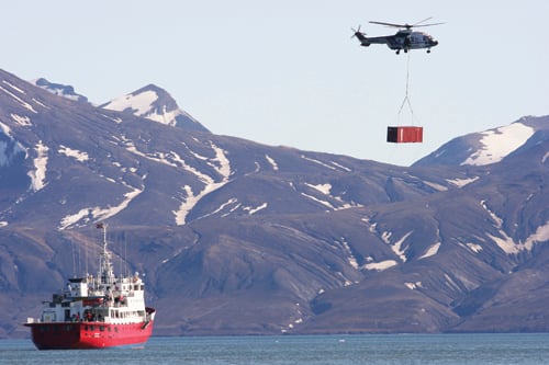
Figure 11.2 MS Nordsyssel and the Governor’s service helicopter.
Source Halvard R. Pedersen, the Governor of Svalbard
In recent years the Governor has increased his emergency response capacity at sea. Several small boats have been purchased and M/S Nordsyssel has more capacity than the Governor’s previous service vessel. The Armed Forces will support the Governor with the resources available in the area at all times. The Coast Guard represents a very important supplementary resource to the Governor’s rescue preparedness. The Governor and the Coast Guard work closely together and cooperation is maintained by several meetings over the course of the year.
The increased cruise tourism also increases the risk of accidents at sea. In the summer of 2007 a vessel was close to a glacier in Hornsund when the glacier calved, throwing ice and water over the boat. Eighteen tourists were injured. After the accident the Governor, in cooperation with the Norwegian Polar Institute, initiated a study to determine a safe distance to glaciers that calve. Based on the report completed in the autumn of 2008, the minimum distance to glaciers should be 200 metres.
11.4.5 Rescue resources in the air
The Governor’s helicopter service is a key element of the overall rescue preparedness in Svalbard. The Governor leases two service helicopters, an AS 332L AWSAR Super Puma helicopter and an AS 365N2 Dauphin helicopter, under a separate agreement with the helicopter company Airlift AS. The Super Puma rescue helicopter has been regularly upgraded with modern equipment and is highly practical and adapted to the special conditions with respect to climate, weather, darkness and type of mission. In 2004 the helicopter base in Svalbard was equipped with a Dauphin back-up helicopter, replacing the former Bell 212 helicopter.
The Dauphin helicopter does not have the same capacity as the Super Puma helicopter when it comes to de-icing equipment and range. However, the helicopter is vital for other rescue, cargo and supervisory assignments that cannot be served by the Super Puma helicopter.
The Office of the Governor carries out between 50 and 60 search and rescue missions and ambulance calls during the year. Together with the helicopters of the Coast Guard and the 330 squadron on Banak (Sea King), the Office of the Governor constitutes the overall rescue preparedness in Svalbard and in adjacent ocean areas. The Armed Forces’ helicopters and air resources are used when available in cooperation with the Joint Rescue Coordination Centre and the Governor as the Rescue Sub Centre.
The helicopters are also able to utilise the fuel depots deployed in a number of places in the archipelago, which gives them a greater operating range. Furthermore, AS Lufttransport operates a Dornier aircraft for commercial flights in Svalbard. This is a long-range aircraft which can be and has been used successfully, for example, for searching for ships in distress. The Governor has installed a communications base in this aircraft which makes it possible to communicate within areas that are not normally covered by the Governor’s regular communications network. This aircraft also has equipment for flying out a rescue drop-kit to a ship in distress.
11.4.6 Assessments
In light of the increase in activities outlined above, it is important that the preparedness at sea and in the air match the level of activity. There is reason to believe that the Governor, as the leader of the Rescue Sub-Centre, will be even more important in the future in this work.
Preparedness at sea around Svalbard consists as mentioned of the Coast Guard and the Governor’s service vessel. In the current situation, the Governor is without a service vessel from December to the end of April. During this period the public preparedness at sea is solely based on the presence of the Coast Guard. As a result of the meltdown of sea-ice and increased traffic in the waters of Svalbard and the Arctic Ocean in general, the Government believes that an extension of the sailing period of the Governor’s service vessel should be considered in order to ensure better preparedness.
The Coast Guard contributes considerable capacity to search and rescue operations, and the Government will consider bolstering the presence of the Coast Guard in the ocean areas of the north.
Cooperating with other states on rescue operations can also be important in areas where there are long distances and few rescue resources. Norway has many multilateral and bilateral agreements on search and rescue and is evaluating the need to enter into more agreements in the future. In the context of the Arctic Council challenges connected with sufficient rescue preparedness have been pointed out in the “Arctic Marine Shipping Assessment – AMSA” report. In addition, the proposal has been made to develop a Memorandum of Understanding for rescue cooperation between Arctic states to strengthen the handling of rescue operations in Arctic waters. This proposal was presented to the April 2009 ministerial meeting of the Arctic Council in Tromsø.