2 Areas of special importance for marine biodiversity in Norwegian waters
There are many areas in Norwegian seas and oceans where species diversity, habitat diversity and biological production are high. The marine environment is very varied, and different elements of ecosystems may be associated with features of the surface water, the water column or the seabed. This is a dynamic environment, and there are wide fluctuations in physical and biological conditions. Ocean currents and the topography of the seabed are two elements that are important in shaping marine ecosystems. Some habitat types are found across wide geographical areas, while others have a more limited distribution. Species and life stages may be spread by ocean currents. Biodiversity in different parts of the oceans depends on physical conditions such as water depth, currents, temperature, salinity, oxygen content and nutrient levels. About 7000 species have been registered in Norwegian waters.
Norway’s marine nature includes valuable species and habitats and areas with specific ecological functions for different species. Shallow coastal waters support some of the most biologically productive habitat types in the world. Habitats in Norway’s coastal waters include cold-water coral reefs, river mouths, areas of shallow water and various types of marine wetlands, which are spawning and nursery areas for important fish stocks and other marine organisms. The Norwegian Sea is relatively shallow close to the mainland, but further from land there are deep-sea areas where water depths reach as much as 3000–4000 m. The Barents Sea and the North Sea and Skagerrak are shallower seas. All of these seas support a rich variety of species and habitats. Biodiversity and biological production are particularly high in certain areas where environmental conditions are favourable where there are specific types of seabed. Areas that are important for biodiversity and biological production are often associated with specific oceanographic or topographic conditions. These areas are not discussed in detail here, but the text below describes some important features and examples of valuable areas in Norwegian marine and coastal waters.
2.1 Areas of importance in coastal waters
The belt of coastal waters closest to the shoreline supports a wide variety of habitats, ecosystems and species. Kelp forests and eelgrass meadows are examples of habitat types where species diversity and biological production are high. Many species use coastal areas as a habitat and feeding area, and there are many areas of special importance for local fish stocks and seabirds along the coast.
Biodiversity has declined from its previous levels in some parts of Norway’s coastal waters. Some species, stocks and habitats need to be rebuilt and restored. The dynamic nature of coastal ecosystems, particularly kelp forests, is of vital importance for fish and crustaceans and in maintaining food supplies for coastal seabirds such as common eider, gulls, terns and cormorants and shags. Environmental pressures are having particularly marked impacts in the North Sea and Skagerrak. Much of the Oslofjord is seriously affected by nutrient inputs as a result of factors including agricultural runoff, climate change and turbid floodwater. Reduced light penetration in the water results in poorer growth of phytoplankton, seaweeds, kelp forests and eelgrass meadows. In addition, it results in oxygen depletion in the bottom water. This can have serious impacts on pelagic and benthic animals and affects species such as cod and sprat that are further up the food chains.
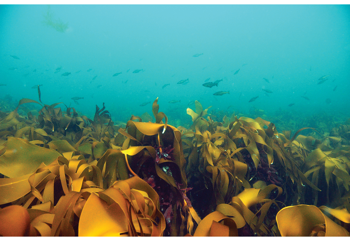
Figure 2.1 Kelp forest, Jærkysten marine protected area, Rogaland.
Photo: Rudolf Svensen
If the environmental status of an area is to be improved through restoration measures, negative pressures must be reduced. The Institute of Marine Research has headed a project on coastal cod in the Oslofjord, which in 2021 published a report on the decline of fish stocks and the ecological status of the Oslofjord. The report discusses the environmental problems mentioned above, but concludes that the outer Oslofjord still offers a suitable habitat for cod and other severely depleted fish stocks. It would therefore be possible to improve ecosystem status by reducing environmental pressures.
Many fjords and harbours along the coast of Norway have been affected by inputs of nutrients and hazardous substances from land. This has resulted in depletion of biodiversity, which has particularly affected the benthic fauna. Remediation of contaminated sediments has been carried out at a number of sites. Action can be taken to remove hazardous substances from biogeochemical cycles and achieve good environmental status for the seabed. In the long term, remediation efforts will allow species and habitats to become re-established, restoring healthy levels of biodiversity. The white paper Working together towards a non-toxic environment and a safer future – Norway’s chemicals policy (Report No. 14 (2006–2007) to the Storting) presented an action plan for contaminated sediments, which focused particularly on removing hazardous substances from biogeochemical cycles in the 17 highest-priority areas. In the 15 years since then, remediation action has been taken in many of these areas, and the results in several of them are encouraging. A renewed, clean seabed provides a basis for the reestablishment of fish stocks and healthy habitats. Both ecological and chemical status are improving, and many species that had been lost are returning.
2.2 Areas in the Barents Sea
The Barents Sea is shallow and includes large bank areas. The marine environment is strongly influenced by the inflow of warm Atlantic water from the southwest and by Arctic water and drift ice in the northeast. These factors enhance nutrient supplies in the upper water layers, thus increasing the growth potential of phyto- and zooplankton and providing the foundation for high biological production in Barents Sea ecosystems. The Barents Sea is the most important nursery and feeding area for several of the large fish stocks that support Norway’s fishing industry. Herring, capelin, cod, haddock, redfish and Greenland halibut use large areas of the Barents Sea throughout their life cycle or at certain stages of it. Eggs and larvae from spawning grounds along the Norwegian mainland coast and in the western part of the Barents Sea drift northwards along the coast and into the central, northern and eastern parts of the Barents Sea, where the fish grow to maturity. The cod and haddock stocks in the Barents Sea are some of the largest and most productive demersal fish stocks in the world, and this is also a nursery area for Norwegian spring-spawning herring, which is one of the world’s largest pelagic fish stocks. The Barents Sea also supports some of the largest concentrations of seabirds in the world. In addition, the northern part of the Barents Sea is an important habitat for a number of marine mammal and seabird species that are not found in areas without ice cover. Several of these populations are of major national and international importance.
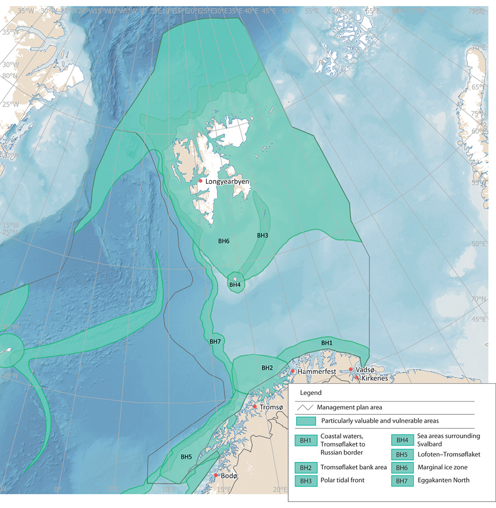
Figure 2.2 Particularly valuable and vulnerable areas in the Barents Sea-Lofoten management plan area.
Source Norwegian Environment Agency
Sea areas surrounding Svalbard
Biodiversity in and around Svalbard is strongly dependent on the sea areas surrounding the archipelago, which form a continuous marine environment. This provides vital food supplies for seabirds, polar bears, whales, walruses, seals and many other species at different levels of the food chains. A number of species are red-listed or are key or indicator species in the ecosystem. Several million seabirds breed in Svalbard, particularly in the parts of the archipelago that face the productive parts of the Barents Sea. The most abundant species are little auk, fulmar, Brünnich’s guillemot and kittiwake.
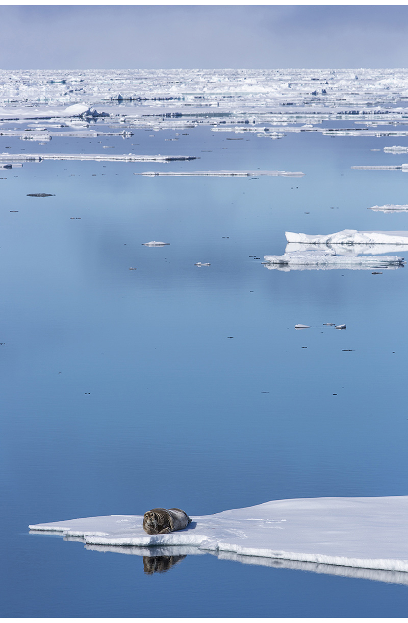
Figure 2.3 Bearded seal in the marginal ice zone.
Photo: Kim Abel/Naturarkivet
Svalbard’s coastal and marine areas are very varied. Biodiversity is high, and there is a wide variety of habitat types, including different types of fjords, mudflats, steep cliffs, strandflats, areas where currents are strong, glacier terminuses, sea ice and marine valleys and bank areas. Sea ice may be present in large parts of the waters around Svalbard, but the marginal ice zone and the production associated with it are highly dynamic, and the position of the zone shifts from Bjørnøya in the south to north of Spitsbergen depending on the time of year. The main concentration of ice is in the area east of Spitsbergen. The seabed in areas where sea ice is present generally has a rich benthic fauna because it is ‘fed’ by ice algae sinking to the bottom. The rich benthic fauna is important for species that feed on the seabed near the coast and in bank areas, including bearded seals, walruses and various seabird species. There are several polynyas (areas of open water surrounded by ice) in the waters around Svalbard. Biological production in these areas is higher than elsewhere, and seabirds and marine mammals therefore congregate in them, particularly during the winter.
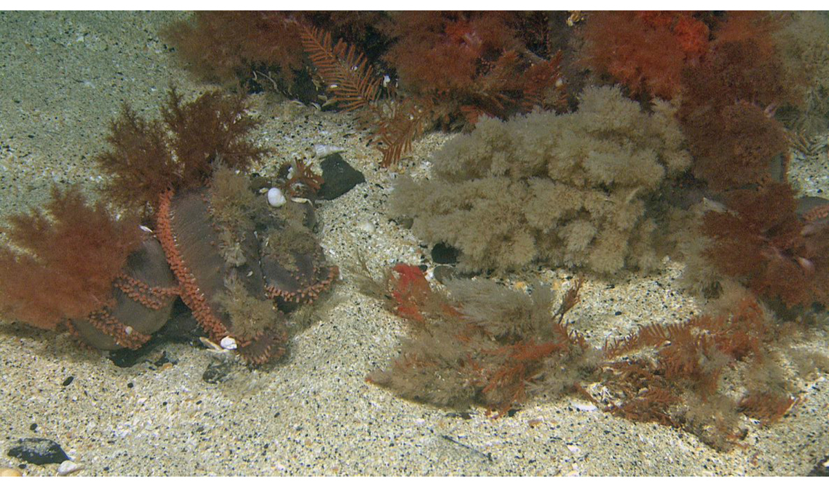
Figure 2.4 Orange-footed sea cucumber (Cucumaria frondosa), Spitsbergen Bank.
Photo: Mareano/Institute of Marine Research
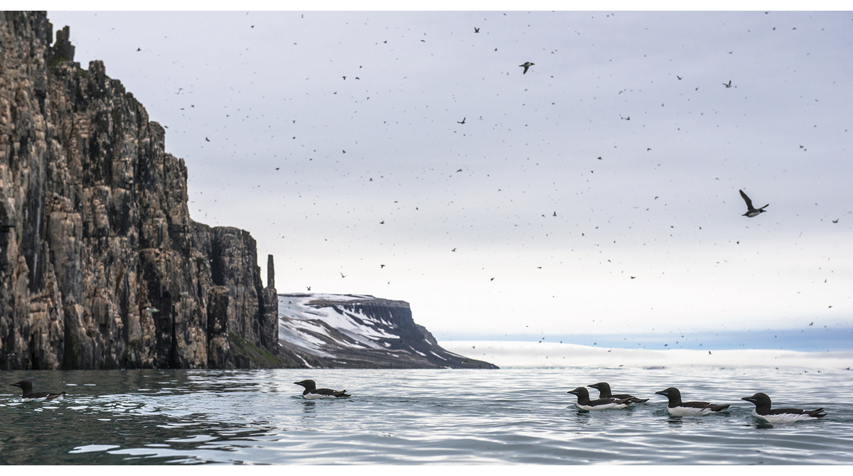
Figure 2.5 Brünnich’s guillemots on the sea in Nordaust-Svalbard nature reserve.
Photo: Bård Bredesen/Naturarkivet
Textbox 2.1 Eggakanten in the Norwegian Sea and Barents Sea

Figure 2.6 Three-dimensional model of Eggakanten (the edge of the continental shelf) west of the island of Røst.
Source Mareano/Geological Survey of Norway, T. Thorsnes
The Eggakanten area runs all the way from Stad at latitude 62 °N to northwestern Svalbard, through both the Norwegian Sea and the Barents Sea. It includes the entire continental slope and extends about 10 km on to the continental shelf. The southern section of Eggakanten is particularly important for a number of fish stocks, several of which are of great commercial value. The topography of the area, the ocean currents and the availability of zooplankton provide excellent conditions for hatching and the earliest life stages of fish. Where the continental slope is steep, environmental conditions change rapidly. There is a strong northerly current that carries heat, nutrients, plankton and fish larvae northwards.
The availability of various life stages and sizes of plankton and fish makes the area important for foraging seabirds and marine mammals. Both fin and blue whales feed on zooplankton, and seabirds feed on fish larvae drifting with the coastal current.
Biological production and biodiversity are generally high along Eggakanten, and the area supports a number of vulnerable habitat types and red-listed species. There are large coral reef complexes, and also biotopes dominated by other species, for example gorgonian forests and sponge communities. The Røstrevet reef complex, the world’s largest known reef of the stony coral Lophelia pertusa, lies in the Eggakanten area, in the upper part of a major underwater landslide.
There are several important bank areas in the Barents Sea. Biological production is particularly high on the Spitsbergen Bank, which has a characteristic benthic fauna and is extremely important for foraging and overwintering seabirds. The high primary production on the Spitsbergen Bank is a crucial feature of the ecosystem in this area. The Spitsbergen Bank is an important feeding and nursery area for several fish species, and also an important foraging area for the nearest large seabird colonies. Unattached calcareous algae on the seabed (rhodoliths) provide a habitat for many benthic species and have an important ecological function on the continental shelf around Svalbard.
2.3 Areas in the Norwegian Sea
There are three main water masses in the Norwegian Sea: Atlantic waters, Arctic waters and coastal waters. Every second, around 8 million tonnes of warm, salty water flows into the Norwegian Sea from the North Atlantic. The mix of water masses with different temperatures and salinities strongly affects the distribution of plankton and fish. Zooplankton such as Calanus finmarchicus and crustaceans like krill are found in large quantities, and are important food for fish stocks such as Norwegian spring-spawning herring, blue whiting and mackerel.

Figure 2.7 Particularly valuable and vulnerable areas in the Norwegian Sea management plan area.
Source Norwegian Environment Agency
The Mid-Atlantic Ridge stretches all the way through the Norwegian Sea from Iceland towards the Arctic Ocean. The ridge system includes several different ridges, deep-sea mountains and fracture zones. In the far north of the Norwegian Sea, just west of the northern part of Spitsbergen, lies the deep-water basin Molloydjupet. Here, the greatest water depth in the North Atlantic has been recorded, 5569 m. The largest mud volcano in the North Atlantic, Håkon Mosby, lies at a depth of 1 270 metres between Svalbard and the Norwegian coast. Mud and methane gas flow upwards from deeper layers in the volcano and support an ecosystem containing an assemblage of species adapted to life with no sunlight. Little is known about other habitat types in such areas and their role in the ecosystems.
Textbox 2.2 The Mid-Atlantic Ridge

Figure 2.8 Sampling from Loki’s Castle hydrothermal vent field.
Source Centre for Deep Sea Research, University of Bergen
There are several hydrothermal vent fields along the Mid-Atlantic Ridge and around Jan Mayen, including Loki’s Castle, Ægirs kilde and Fåvne, and several extinct fields. A distinctive fauna including a number of red-listed species is found in areas around hydrothermal vents. Seafloor spreading is very slow along the Knipovich Ridge, and the hydrothermal vents in this area are therefore very old by global standards. The Loki’s Castle vent field on Mohn’s Ridge is estimated to be about 10 000 years old.
The fauna around hydrothermal vent fields is specialised to survive in the absence of sunlight, instead making use of chemical energy (chemosynthesis), and includes animals living in symbiosis with chemosynthetic bacteria. The fauna is dependent on the hydrothermal vents and the characteristic chemical and physical environment around them. Organisms living in extreme deep-sea environments have unique adaptations to enable them to survive in the extreme conditions. Microorganisms and biomolecules can be harvested from hydrothermal vent fields for industrial and medical uses (marine bioprospecting). Little is known about interactions between benthic ecosystems and those in the water column above, and this will require further research in future.
Important mineral deposits have been found along the Mid-Atlantic Ridge, and parts of it may therefore be of interest for mineral extraction from the seabed.

Figure 2.9 Northern part of Mohn’s Ridge, a section of the Mid-Atlantic Ridge.
Source Geological Survey of Norway, Mareano, Norwegian Petroleum Directorate and Norwegian Mapping Authority
2.4 Areas in the North Sea and Skagerrak
Phytoplankton production (primary production) is generally high in the North Sea. This is mainly because the water is relatively shallow, and effective mixing in the water column carries nutrient-rich bottom water into the surface layers where sunlight penetrates.
Areas of sandeel habitat in the North Sea have a characteristic bottom habitat where the seabed consists of coarse sand and gravel, and are important nursery and spawning areas for lesser sandeels. Sandeels are a key species that provide food for seabirds, larger fish and marine mammals, and are also an important commercial fish stock. Parts of the North Sea are also important wintering areas for seabirds including the common guillemot.
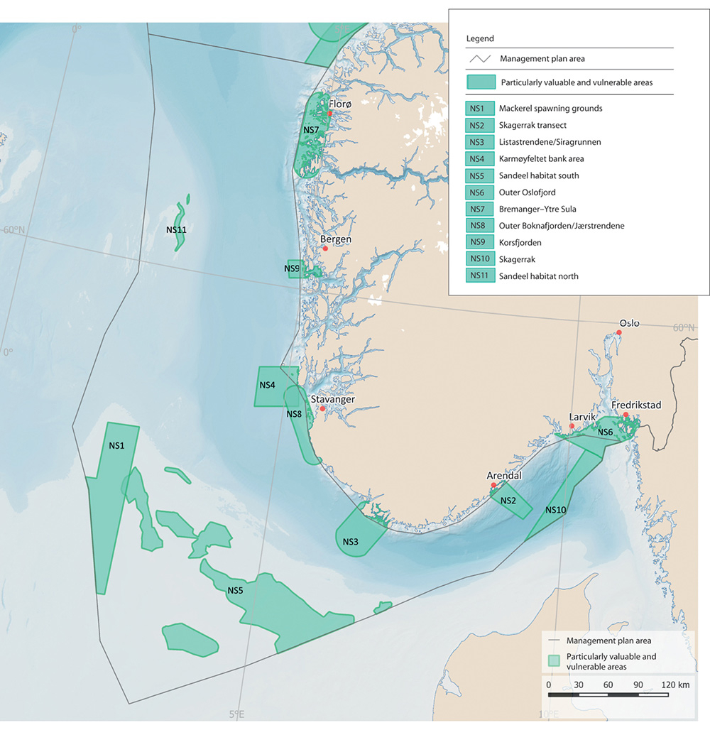
Figure 2.10 Particularly valuable and vulnerable areas in the North Sea–Skagerrak management plan area.
Source Norwegian Environment Agency
Textbox 2.3 Kelp forests and carbon storage in inshore waters
Kelp forests are recognised as some of the most productive and dynamic ecosystems on Earth, and have important ecological functions for algae, molluscs, crustaceans, birds and marine mammals. Because of their high biodiversity, these areas are sometimes referred to as rainforests of the sea. Kelp forests are spawning, nursery and feeding areas for many fish species, and they also support a wide variety of other species. Various species of algae and sessile animal species live on the kelp itself (epiphytic organisms), while other mobile species may be found on the kelp plants, on the seabed below or in the water column within and above the kelp forest. Fish such as pollack, saithe and cod often use the water column just above kelp forests, while wrasses, cod, saithe, various small crustaceans, sea urchins, starfish, sea anemones, gastropods and molluscs find shelter among the kelp plants.
Several kelp species occur in Norway, but kelp forests most commonly consist of Laminaria hyperborea or sugar kelp (Saccharina latissima). In addition to kelp forests, there are seaweed beds, eelgrass meadows and soft-bottom areas in inshore waters, all of which have important functions for many species, both purely aquatic species and species that spend most of their time above the water surface, such as seabirds and otters. Many fish populations, including several of the commercially harvested stocks, visit coastal waters to spawn. A number of the spawning areas are clearly delimited geographically, and fish spawn in the same areas every year.
The same habitat types play an important role in carbon storage in coastal waters. Norwegian research results indicate that the quantity of carbon from kelp forests transferred to sediments in Norwegian waters may be similar to the quantity stored in Norwegian forest soils. However, it is uncertain how much of this can be said to be long-term storage, or sequestration, of carbon, because the carbon is not stored where the vegetation grows, but is transported to deep-sea areas.
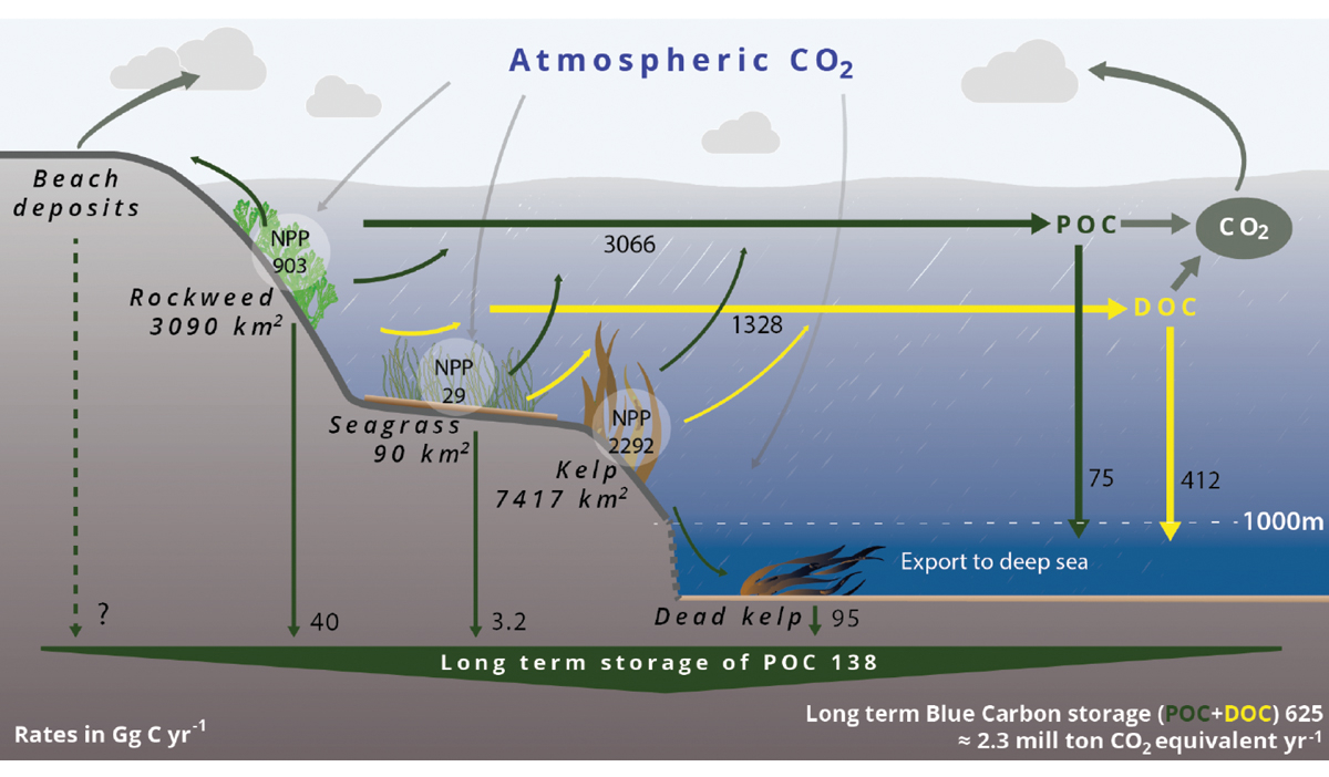
Figure 2.11 Norwegian blue carbon budget including kelp forests, seaweed (rockweed) beds and eelgrass meadows. Estimated area, rates of net primary production (NPP), export rates, and sequestration of particulate organic carbon (POC) and dissolved organic carbon (DOC) are given for each habitat. POC sequestration occurs in sediments on the continental shelf and in the deep sea (below 1 000 m, termed `long-term storage’), while DOC sequestration occurs only in the deep sea (below 1 000 m).
Source Nordic Blue Carbon Project, H. Frigstad et al., 2020
The Norwegian Trench, which is 200–700 m deep, separates Norwegian coastal waters from the shallower parts of the North Sea further west and south. The coastal side of the Norwegian Trench slopes steeply to the deepest water just off the Norwegian coast, while the offshore side rises more gently to the North Sea Plateau west and south of the Trench. The deepest area is in the Skagerrak south of Arendal. The Norwegian Trench is the only place where the copepod Calanus finmarchicus overwinters in the North Sea–Skagerrak management plan area. It also supports large quantities of krill and is the only area where the North Sea has a mesopelagic fauna, including fish. There are greater concentrations of bamboo coral (Isidella) in the Norwegian Trench than anywhere else in Norway except in certain fjords. It also supports one of the largest populations of the shrimp Pandalus borealis anywhere in the Northeast Atlantic.
The outer Oslofjord is an important area for breeding, migrating and overwintering seabirds. The largest known cold-water coral reef in sheltered waters is also in this area. In addition, both the Norwegian and the Swedish waters of the outer Oslofjord are important for seals.
2.5 Areas of habitats that are important for carbon storage
The oceans represent the planet’s largest pool of organic carbon (carbon originating from the decomposition of living organisms). According to the Intergovernmental Panel on Climate Change (IPCC), most carbon in the oceans is in the form of dissolved inorganic carbon in the water column. In addition, a large quantity of carbon is stored in surface sediments on the seabed and as dissolved organic carbon in the water column, and smaller amounts in marine biota (see Figure 2.11). The IPCC also highlights the potential of ‘coastal blue carbon ecosystems’ for reducing the risks and impacts of climate change.1 Coastal ecosystems that are important for carbon storage include kelp forests, seaweed beds, eelgrass meadows, saltmarshes and soft-bottom areas in the intertidal zone.
In a recent report from the Nordic Blue Carbon Project2, it was estimated that Norwegian kelp forests alone account for 46 % of long-term storage of CO2 from blue forests in the Nordic region, corresponding to around 3.6 % of total annual Norwegian emissions.
The Geological Survey of Norway investigated organic carbon stocks and accumulation rates in the North Sea and Skagerrak. The study found that of the overall stock of organic carbon in the upper 0.1 m of sediments in these areas, about 26 % is stored in the Norwegian Trough, which only makes up about 11 % of the entire area. Accumulation rates are highest in the Norwegian Trough, which accounts for 87 % of total organic carbon accumulation in the North Sea and Skagerrak.
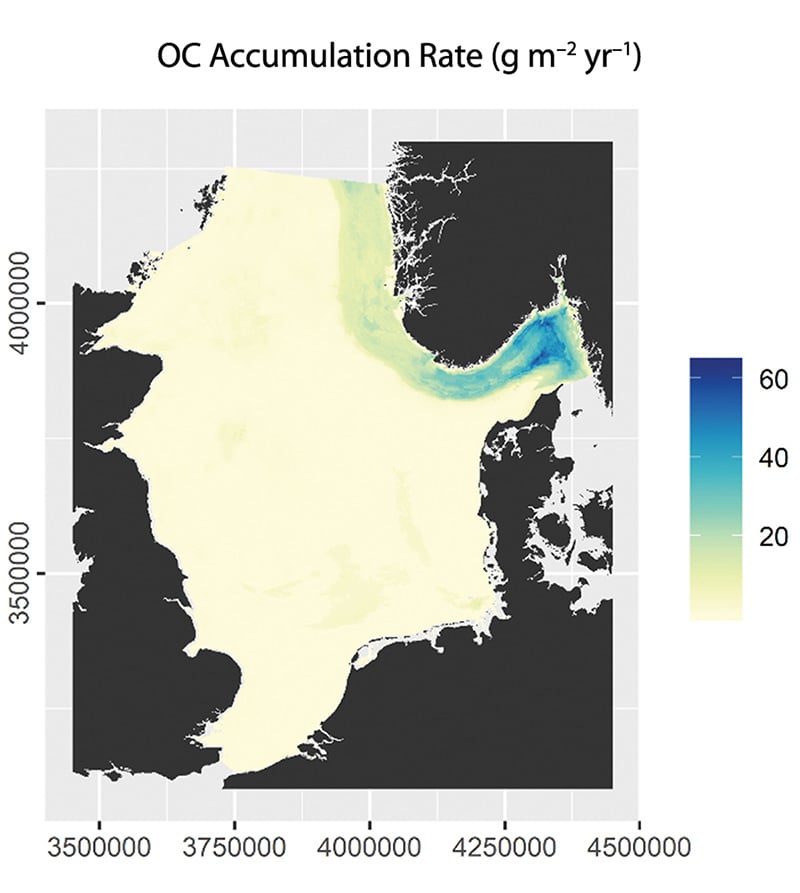
Figure 2.12 Estimated annual organic carbon accumulation rate in sediments in the North Sea and Skagerrak. The accumulation rate is highest in the Norwegian Trough, but there are uncertainties associated with the modelled figures for accumulation of carbon in the seabed.
Source Organic carbon densities and accumulation rates in surface sediments of the North Sea and Skagerrak, Diesing et al., 2021
Although kelp forests cover a relatively small area compared with terrestrial vegetation, their annual production is high and they therefore make a substantial contribution to carbon storage, see Figure 2.13.

Figure 2.13 Per area carbon standing stock and carbon flux via detritus for dominant habitat-forming primary producers in Europe. The carbon stock contained within each habitat is partitioned into the amount stored in soils (dark blue bars) and in living plant tissues (light blue bars), which includes above and below-ground living biomass.
Source Carbon assimilation and transfer through kelp forests in the NE Atlantic is diminished under a warmer ocean climate, A. Pessarrodona et al., 2018
As part of the scientific basis for the work of the Ocean Panel, the potential contribution from climate action areas to mitigating climate change in 2050 has been calculated, as shown in Figure 2.14. This shows the possible contribution of ecosystems to carbon storage together with other ocean-based action areas.

Figure 2.14 Potential contribution of ocean-based action areas to mitigating climate change in 2050.
Source Hoegh-Guldberg et al. 2019 (Ocean Panel)
Recent research has also focused on the implications of bottom trawling for the release of carbon stored in seabed sediments. The results indicate that establishing marine protected areas may have benefits in three different ways – by protecting biodiversity, by increasing the yield from fisheries and by safeguarding marine carbon stocks that are threatened by human activity.
2.6 Mapping and building up knowledge about areas of importance for marine biodiversity
Sound scientific knowledge is an essential basis for ocean management and conservation. Norway’s ocean management regime is based on a substantial body of knowledge acquired through mapping, research and environmental monitoring. Norway is investing considerable effort in building up more knowledge about its seas and oceans. Some key initiatives are described below. However, there are still major gaps in our knowledge and understanding of the marine environment, and further knowledge development is needed. Further developing our understanding is a vital basis for sustainable management of marine ecosystems.
2.6.1 The MAREANO programme
The MAREANO programme was begun in 2005 to satisfy the need for more knowledge of conditions on the seabed in Norwegian waters. The programme has provided valuable information through mapping of depth and topography, species diversity, habitat types, chemical conditions and pollutants in sediments, and geological formations on the seabed. Data from the MAREANO surveys are made available on the programme’s website and through the Norway Digital programme.
Mapping of the seabed generates a great deal of new information on the distribution of habitats and species and the pressures and impacts associated with human activity. The information can be used to improve the management regime and provide better protection for vulnerable habitat types. Priority has been given to areas where there are or may be important species and habitat types or natural resources that could be affected by existing or new human activities. In the process of developing the scientific basis for the ocean management plans, data obtained through MAREANO has confirmed the environmental value of the areas identified as particularly valuable and vulnerable.
The MAREANO programme has mapped many new coral reefs. As a result of the new information, ten new areas of cold-water coral reefs in Norwegian waters have been given special protection by designation as marine protected areas under the Marine Resources Act. Knowledge acquired through the MAREANO programme is an important basis for sustainable management of the seabed, for example by adding to the knowledge base on vulnerable habitat types such as corals and sponge communities, and reduces the risk of damage to such habitats during fisheries and other activities.
Knowledge is also needed to ensure a representative selection and ecological coherence when using areas-based conservation measures in Norwegian waters, and the information gathered through the MAREANO programme is an important part of the knowledge base.
The petroleum industry has also provided a great deal of new, valuable knowledge about the seabed in Norwegian waters in connection with baseline surveys carried out before well drilling and during the planning phase of field development and pipeline route surveys. This knowledge has provided a vital basis for planning and regulating activities in areas where there are vulnerable species and habitats.

Figure 2.15 Areas mapped by the MAREANO programme.
Source MAREANO
2.6.2 Mapping biodiversity in coastal waters
In the period 2003–2019, habitats in coastal waters that support high biodiversity were mapped and their value classified as part of the national programme for mapping coastal marine biodiversity. The habitats included eelgrass meadows, shell sand deposits, kelp forests and soft-bottom areas, and in addition key areas for certain species such as scallops and coastal cod (spawning areas). Various sectors and the municipalities use the data in planning processes, and they can also be accessed through various map portals (Naturbase and Yggdrasil) and the map catalogue Geonorge. Habitats can be classified as being of national, regional or local value.
The programme has built up more knowledge about valuable habitats, and this is used as part of the basis for planning and decisions on development projects and other decisions relating to activities in coastal waters.
Further mapping of habitats in coastal waters is now under way, starting in the Oslofjord.

Figure 2.16 Eelgrass meadow.
Photo: Eli Rinde/Norwegian Institute for Water Research
The Norwegian Mapping Authority, the Geological Survey of Norway and the Institute of Marine Research are cooperating on a project to develop seabed maps for Norwegian coastal waters. The project will map the seabed along the coast of Norway and compile geological, chemical and biological data. The data will be made publicly available, and the purpose of the project is to ensure a greater degree of knowledge-based management and sustainable use of Norwegian waters. In 2020, mapping was started in three pilot areas: Kvænangen and Skjervøy municipalities in Troms og Finnmark county, Stavanger municipality in Rogaland, and Ålesund and Giske municipalities in Møre og Romsdal.
2.6.3 SEAPOP and SEATRACK
SEAPOP is a long-term mapping and monitoring programme for Norwegian seabirds, and was established in 2005. The programme covers the Norwegian mainland coast, Svalbard and adjacent sea areas, and is intended to provide and maintain baseline information on seabirds. The aim is to improve management of the marine environment. There is a special focus on acquiring data that make it possible to distinguish the effects of human activity from those that are largely a result of natural variability. Data and knowledge acquired through the programme are processed and organised on an ongoing basis so that they can be made available to different user groups through the programme’s website.

Figure 2.17 The key sites used by the SEAPOP programme. The colours of the symbols indicate the seas the different sites represent: the northern Barents Sea (dark blue), the southern Barents Sea (light blue), the Norwegian Sea (green), the North Sea (orange) and the Skagerrak (red). Split colours indicate that a site represents two different seas. Large circles indicate the main sites, and small circles the nearby sub-localities. Triangles indicate key sites where the focus is on a single species: ivory gull (Barentsøya), common eider (Grindøya), lesser black-backed gull (Sør-Helgeland) and shag (Rogaland).
Source SEAPOP
The SEAPOP programme aims to map the spatial and temporal distribution of breeding, moulting, staging and wintering seabirds along the entire coast of Norway, including Svalbard and Jan Mayen, in a ten-year cycle. Seabird distribution in the large open sea areas covered by the programme will largely be predicted using multidisciplinary models that include various environmental factors that influence seabirds. This work is being carried out in close cooperation with the Institute of Marine Research, and will to a large extent be based on data collected during the Institute’s ecosystem surveys in these areas.

Figure 2.18 Map showing important areas for pelagic seabirds. The figure shows the maximum monthly sum of the share of populations of common guillemot, Brünnich’s guillemot, puffin and kittiwake from Norwegian, Russian and British seabird colonies using different areas. The birds in these populations breed around the North Sea, Norwegian Sea, Barents Sea and Greenland Sea.
Source SEAPOP
The SEATRACK module is mapping the non-breeding distribution of seabirds, originally for Norwegian breeding populations and populations in neighbouring countries that use Norwegian waters, but now expanded to include the whole North Atlantic. By following birds from breeding populations that are being monitored (numbers, reproductive success and survival), it has proved possible to develop new and revolutionary insights into patterns of use of different areas, which populations seabirds belong to, their migration routes and wintering areas, and how vulnerable seabird populations are in Norwegian waters.
2.6.4 Particularly valuable and vulnerable areas
Particularly valuable and vulnerable areas have been identified as being of great importance for biodiversity and biological production in an entire management plan area. They are selected using predefined criteria, the main ones being that the area concerned is important for biodiversity or for biological production. The criteria used in a review of all these areas in 2021 were the same as the criteria for identifying ecologically or biologically significant marine areas (EBSAs) under the Convention on Biological Diversity (CBD). As a result of the progress that has been made in mapping Norwegian waters, we now know more about the importance of the particularly valuable and vulnerable areas. Mapping of the seabed and of seabird distribution and habitat use have been especially important in confirming and strengthening the knowledge base.
Marine areas of importance for biodiversity and biological production are often found where there are special topographic or oceanographic features or transitional zones between the sea and land or ice.
Vulnerability can be defined as a measure of how prone an area is to be negatively affected by human activity or changes in environmental conditions; conversely, its resilience is a measure of how well it can resist or recover from damage. In other words, vulnerability is assessed as an attribute of the area or species and habitats, regardless of whether or not human activity or other environmental pressures exist in the area. This means that an area can be identified as vulnerable to one or more human activities even if these are not being carried out at present and are unlikely to be started up in the near future. Because physical, chemical and biological parameters vary from one area to another, so does vulnerability. In addition, a specific area is rarely equally vulnerable throughout the year or to all types of pressures. The vulnerability of the different species found in an area also differs. We do not know enough to quantify vulnerability to all types of environmental pressures for all of the particularly valuable and vulnerable areas, but general vulnerability to acute oil pollution has been analysed at fairly high resolution. The ecological value of the particularly valuable and vulnerable areas stretches beyond their own boundaries, because they are key to maintaining ecological functions, biodiversity and productivity in wider areas.
2.7 The importance of area-based conservation of the marine environment
Both the IPCC and the Intergovernmental Science-Policy Platform on Biodiversity and Ecosystem Services (IPBES) have concluded that ocean governance must be adapted to the accelerating pace of climate and environmental change. Ocean governance must take into account the potential impacts of climate change in combination with other drivers of change, and it must be possible to adapt quickly as the situation changes. The IPCC and IPBES have highlighted the importance of developing well designed networks of protected areas to safeguard key marine biodiversity areas. This can help to reduce cumulative impacts on areas and ecosystems that are given special protection, and to protect areas that will become important as the distribution of species and ecosystems changes in response to climate change.

Figure 2.19 Overview of particularly valuable and vulnerable areas in the Norwegian ocean management plan areas.
Source Norwegian Environment Agency
IPBES has estimated that more than 40 % of the world’s ocean area is already strongly affected by human activity, and that cumulative impacts are increasing across two thirds of the total area. There are wide variations between different ocean areas. Coastal marine ecosystems in densely populated areas and in tropical waters are under the greatest pressure. However, climate change is also putting considerable pressure on the polar seas.
According to IPBES, there are four main direct drivers of change in marine ecosystems. The most important of these globally is fishing and other harvesting of marine organisms, followed by land- and sea-use change, including the development of infrastructure and aquaculture in the coastal zone. The third driver is climate change, and the fourth is inputs of pollutants and waste. The relative importance of these drivers varies between different parts of the world’s oceans. Climate change is often identified as a driver that is increasingly intensifying the impacts of other factors.
The changing status of Arctic ecosystems and tropical coral reefs is a frequently used example of this effect of climate change. The environmental status of Norway’s seas is in many respects good, but the impacts of climate change are becoming stronger, and are clearly affecting the status of ecosystems in both the North Sea and the Barents Sea. Conservation measures are a tool for safeguarding marine biodiversity and ecological functions as conditions change in the marine environment.
The oceans play a vital role in the climate system as a carbon pool and heat store, but at the same time marine ecosystems are being strongly affected by climate change and ocean acidification. As the seawater becomes warmer and more acidic, living conditions in the marine environment change, and this may also have serious impacts for people who rely on ocean resources. Climate change will have particularly serious impacts in northerly waters, and temperatures and pH levels will change. In addition, the sea ice is melting and run-off from Arctic rivers is increasing. Climate change adaptation and mitigation measures must go hand in hand to counteract serious consequences of climate change. At the same time, marine ecosystems can play a key role in the fight against climate change and in adaptation to climate change. ‘Blue forests’ such as kelp forests, seaweed beds and eelgrass meadows have substantial carbon storage capacity and can protect the coastline against erosion, storms, and flooding. Blue forests are also important for marine productivity and biodiversity.
According to IPBES, a mix of policy instruments and measures is needed to conserve fish stocks and marine species and ecosystems, implemented on land, in freshwater and in the oceans. Coordination across sectors and stakeholders on the use of open oceans will also be needed. One type of action that IPBES highlights as effective is the expansion and strengthening of representative networks of protected areas. Others are ecosystem-based management, effective fisheries quota systems, marine spatial management, protecting key marine biodiversity areas, and reducing pollution from land.
The IPCC emphasises that adaptation of ocean governance frameworks to make them climate-resilient to a large extent involves reducing or limiting other direct drivers of change in marine and coastal environments, such as land- and sea-use change, pollution and harvesting. Conservation of ecosystems through marine protected areas and networks of such areas, and other effective area-based conservation measures, is highlighted as particularly important. This can help to reduce cumulative impacts on areas and ecosystems that are given special protection, and to ensure that species can maintain viable, productive populations and that ecosystem functioning is maintained as distribution patterns shift towards the poles in response to climate change.
The International Union for the Conservation of Nature (IUCN) and the Food and Agriculture Organization of the United Nations (FAO) are two international organisations that are playing a particularly important role in developing the scientific basis for marine protection and other effective area-based conservation measures. They also provide countries with advice on the establishment and management of such areas.
IUCN considers MPAs to be an important tool for conserving and rebuilding marine biodiversity, which in turn is important for human livelihoods, health and food security. According to IUCN, proven benefits from MPAs include:

Figure 2.20 Impacts of human activity on the seabed. Left: map of trawl tracks (blue) from vessels over 15 m in length in the period 2011–2019. Right: sonar images of the seabed in the outer Oslofjord showing the impacts of trawling. Close-up of trawl tracks at a depth of 139 m in the outer Oslofjord. Deeplet sea anemones (Bolocera tuediae) in an area where the benthic fauna is intact, at a depth of 455 m in the outer Oslofjord.
Photo: Frisk Oslofjord project/Institute of Marine Research
Source Map: Directorate of Fisheries. Sonar images: Frisk Oslofjord project/Kongsberg Maritime.
conservation of biodiversity and ecosystems;
improved fisheries management;
greater resilience to the impacts of climate change;
carbon capture and storage (‘blue carbon’);
disaster risk reduction – protection of coastal areas against extreme weather, tsunamis and coastal erosion;
restoration of ecosystems such as coral reefs, mangroves and seagrass meadows;
tourism and recreation – economic and health benefits to coastal communities;
protection of cultural and spiritual resources and values;
research and education;
models of fair and open governance.
These benefits depend on good design, the resources available to support protection measures, whether protection goals are met through fair governance and effective management, and the scale at which MPAs work together as a conservation network. The benefits and opportunities associated with well designed and managed MPAs have been shown to increase over time. Other factors that are important for achieving satisfactory results from marine protection are restrictions on fishing, proper enforcement and that the protected areas are large enough.
According to FAO, the two primary reasons for establishing MPAs are for biodiversity conservation and sustainable fisheries management. In the context of fisheries management, FAO describes MPAs as geographically defined areas that afford natural resources greater protection than in other areas. FAO views MPAs as an integral part of spatial management and larger frameworks for integrated ocean management, integrated coastal zone management and marine spatial planning. FAO also emphasises the importance of designing and managing an MPA network as a synergistic system that may be more resilient to threats such as climate change. At the same time, FAO makes it clear that MPAs cannot solve all fishery management problems or improve food security, but that the best results are achieved by including marine protection as one of several instruments in an integrated, ecosystem-based management regime.
2.8 Marine ecosystem restoration
Ecosystem restoration is the process of assisting the recovery of an ecosystem that has been degraded, damaged, or destroyed. Conservation measures can contribute to the restoration of such areas. Both active restoration measures and passive restoration can be used in the recovery of marine ecosystems or in improving their status. Large-scale natural restoration and recolonisation in selected conservation areas where this is appropriate can make ecosystems more resilient and provide space and time for ecosystems to recover naturally. In areas where human activity has caused environmental degradation, resulting in deterioration of ecological status and disruption of natural processes, passive restoration will allow species to recolonise such areas naturally, populations to develop a healthy age structure and ecosystem functions to recover. These processes will provide refuges for biodiversity, increase biological production, allow the development of a basis for harvesting and recharge carbon pools. Areas restored in this way will also play a part in making ecosystems more resilient to current and future climate change. According to recent scientific research, up to 10 years is required to restore benthic communities in the North Sea, while the average time needed to restore entire ecosystems is estimated at 20 years.

Figure 2.21 A no-take zone for lobster. Illustration of documented and anticipated effects of strict conservation measures, based on research carried out by the Institute of Marine Research in connection with no-take zones for lobster in the Skagerrak.
Source H. E. Tørresen/Institute of Marine Research
Passive restoration – ‘rewilding’
A passive restoration approach involves moderating or eliminating factors that cause ecological degradation and allowing natural recovery to improve the ecological status of an area. This is often referred to as ‘rewilding’. For rewilding to be successful, it is important that protected areas are large enough to avoid too much pressure from external factors.
Allowing benthic communities to recover can improve the ecological status of larger parts of an ecosystem. Benthic communities play an important role in the entire ecosystem, but in many areas they have been damaged and depleted, for instance by prolonged periods of bottom trawling, by releases of organic material or hazardous substances, or by the deposition of waste, which blankets the natural seabed. Soft bottom areas that remain undisturbed can also play a part in carbon sequestration.

Figure 2.22 Releasing a lobster as part of an experimental fishery.
Photo: Bård Bredesen/Naturarkivet
One conservation measure that can be categorised as rewilding is the establishment of no-take zones for lobster. A number of no-take zones have been established in the southern half of Norway, and the lobster populations have been found to grow when fishing pressure is reduced. The effect is not restricted to the no-take zone, but can also be registered in the surrounding area. No-take zones appear to have a positive effect on fish stocks as well as lobster populations.
Various other measures can also be used within fisheries management to rebuild fish stocks. A restoration plan has been prepared for coastal cod, and is now being revised. The common eel is red-listed as vulnerable, and catches of the species have therefore been banned.
Active restoration measures
In addition to marine protection and other effective area-based conservation measures as nature-based solutions, ecosystem restoration includes measures to re-establish or improve vulnerable habitats in areas where the processes of natural species recruitment and recolonisation have been weakened. Examples are re-establishing eelgrass meadows and planting sugar kelp. Restoration also includes larger-scale work to rebuild entire habitats.
A great deal of work has been done on marine restoration internationally, and many projects involve the restoration of different marine habitats. In Norway, some of the largest-scale examples of active restoration of marine biodiversity involve remediation of contaminated sediments in ports. At some sites, habitat enhancement measures have been implemented on the seabed to encourage certain species to return, for example providing shelter for lobsters or spreading shell sand and pebbles on the clean seabed. Monitoring in these areas shows that a restored, clean seabed provides a basis for the re-establishment of fish and healthy habitats. Many species that had disappeared are returning. Successful remediation projects have been carried out in a number of highly polluted ports, including Oslo, Trondheim, Sandefjord, Bergen (Puddefjorden), Harstad, Tromsø and Horten.