Agreed Minutes
on the Delimitation of the Continental Shelf beyond 200 Nautical Miles between the Faroe Islands, Iceland and Norway in the Southern Part of the Banana Hole of the Northeast Atlantic
Guidelines | Date: 21/09/2006 | Ministry of Foreign Affairs
Agreed Minutes
on the Delimitation of the Continental Shelf beyond 200
Nautical Miles
between the Faroe Islands, Iceland and Norway
in the Southern Part of the Banana Hole of the Northeast
Atlantic
1. The Minister for Foreign Affairs of the Kingdom of Denmark together with the Prime Minister of the Government of the Faroes, the Minister for Foreign Affairs of Iceland and the Minister of Foreign Affairs of the Kingdom of Norway wish to effect the delimitations of the continental shelf areas beyond 200 nautical miles from the baselines between the Faroe Islands, Iceland, Mainland Norway and Jan Mayen, subject to rights and obligations under the United Nations Convention on the Law of the Sea, hereinafter referred to as “the Convention”. This will be done taking into account, inter alia, the functions of the Commission on the Limits of the Continental Shelf established in accordance with Annex II to the Convention, hereinafter referred to as “the Commission”.
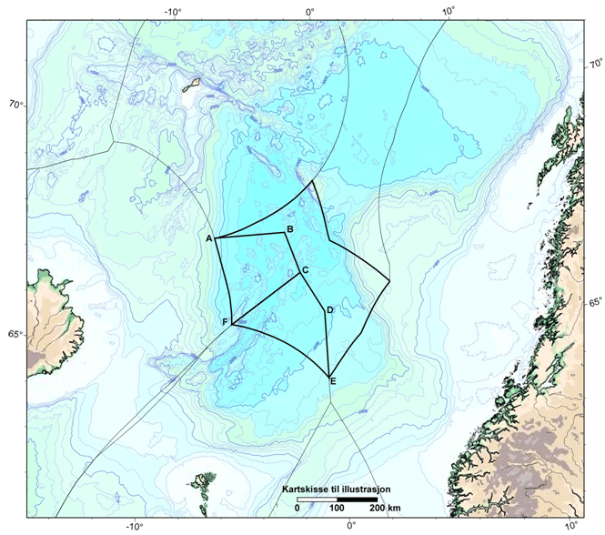
2. They are in agreement that the bilateral delimitations of the continental shelf will be based on straight geodetic lines connecting the following points, defined in the World Geodetic System 1984 (WGS84):
Iceland/Norway
(A) | 67° 36′ 40.54′′ N | 6° 38′ 18.95′′ W |
(B) | 67° 43′ 06.51′′ N | 2° 30′ 45.12′′ W |
(C) | 66° 49′ 15.75′′ N | 1° 41′ 43.56′′ W |
Faroe Islands/Iceland
(C) | 66° 49′ 15.75′′ N | 1° 41′ 43.56′′ W |
(F) | 65° 41′ 22.63′′ N | 5° 34′ 42.22′′ W |
Faroe Islands /Norway
(C) | 66° 49′ 15.75′′ N | 1° 41′ 43.56′′ W |
(D) | 65° 54′ 43.74′′ N | 0° 29′ 13.23′′ W |
(E) | 64° 25′ 58.14′′ N | 0° 29′ 19.30′′ W |
By way of illustration, these lines and the points listed above have been drawn on the chart appended to these Agreed Minutes (Appendix I).
3. The lines established in paragraph 2 do not restrict the use of relevant information by the States when submitting documentation concerning the outer limits of the continental shelf to the Commission.
4. These Agreed Minutes are based on the shared view that the whole area concerned consists of continuous continental shelf. If, after consideration of national data or other material by the Commission, it is ascertained that any part thereof belongs to “the Area” as defined in Article 1 of the Convention, i.e. that this part does not consist of continental shelf appertaining to any of the coastal States, the coastal State(s) concerned will establish the outer limits of the continental shelf in accordance with Article 76 (8) of the Convention, without this otherwise affecting the lines established in paragraph 2.
5. Norway intends to submit its documentation concerning the outer limits of its continental shelf in the area to the Commission in 2006. Denmark/the Faroe Islands and Iceland intend to submit their respective documentation concerning the outer limits of their continental shelf in the area to the Commission as soon as possible.
6. Each State will, when submitting its documentation concerning the outer limits of its continental shelf in the area, request that the Commission consider it and make its recommendations on this basis, without prejudice to the submission of documentation by the other States at a later stage or to delimitation of the continental shelf between the three States. The State concerned will in this connection declare that such a request is agreed between the three States.
7. When one State submits documentation to the Commission, the other States will notify the Secretary-General of the United Nations in accordance with the Commission’s rules of procedure that they do not object to the Commission considering the documentation and making recommendations on this basis, without prejudice to the submission of documentation by these States at a later stage or to the question of bilateral delimitations of the continental shelf between the three States.
8. If, after consideration by the Commission, one or more of the States has not documented that the area of its continental shelf beyond 200 nautical miles corresponds in size, as a minimum, to the area that falls to the same State according to paragraph 2, the lines established in paragraph 2 will be adjusted. This adjustment will ensure a corresponding reduction of the area that falls to the State concerned and the distribution of the excess area to the remaining State or States that document to the Commission areas of continental shelf more extensive than the areas that follow from paragraph 2.
·- If Denmark/the Faroe Islands fails to document an area of continental shelf beyond 200 nautical miles of at least 27 000 km 2>, the excess area will be shared between Iceland (40 per cent) and Norway (60 per cent).
- ·
- If Iceland fails to document an area of continental shelf beyond 200 nautical miles of at least 29 000 km 2>, the excess area will be shared between Denmark/the Faroe Islands (40 per cent) and Norway (60 per cent).
- ·
- If Norway fails to document an area of continental shelf beyond 200 nautical miles of at least 55 528 km 2>, the excess area will be shared between Denmark/the Faroe Islands (50 per cent) and Iceland (50 per cent).
If only one of the States is able to document a sufficient area of the continental shelf, the excess area will fall to that State.
No State shall be allocated an area of continental shelf larger than the area it is able to document to the Commission.
Any adjustment of the lines established in paragraph 2 will be made in such a way that it causes the smallest possible departure from their general direction and the number of turning points, primarily by moving point (C).
9. As soon as possible, and no later than three months after the States have concluded the procedure set out in Article 76 (8) of the Convention, the States will meet with a view to simultaneously concluding three parallel bilateral agreements on the final determination of the boundary lines in accordance with these Agreed Minutes and their appendices, including the Model Agreement contained in Appendix II. If such a meeting has not been held by the end of 2011, the States will initiate consultations on the further follow-up.
10. The Ministers have agreed that the final delimitations will be effected by the simultaneous entry into force of the three bilateral agreements, following notification that internal requirements have been fulfilled to this end.
11. These Agreed Minutes constitute a joint statement of the Ministers’ agreement on the procedure for establishing the delimitations of the continental shelf between the States in the area, subject to fulfilment of their internal requirements.
These Agreed Minutes constitute a historic step that reflects the extremely close and good neighbourly relations between Denmark/the Faroe Islands, Iceland and Norway, their common commitment to promoting the international law of the sea and the importance they attach to the United Nations Convention on the Law of the Sea as the legal framework for the peaceful uses of the oceans and seas.
Signed in triplicate at New York on 20 September 2006 in the English language.
The Minister for Foreign Affairs of the Kingdom of Denmark
The Prime Minister of the Government of the Faroes
The Minister for Foreign Affairs of Iceland
The Minister of Foreign Affairs of the Kingdom of Norway