2 Background
2.1 Introduction
In the past, comprehensive white papers on Svalbard have been presented approximately every 10 years. The white papers have each contributed to guiding the archipelago’s development for a number of years, and the comprehensive review process has contributed to balanced development within the framework established by the Svalbard policy objectives.
The overriding objectives of the Svalbard policy have been unchanged for many years, and remain so. One objective is the maintenance of Norwegian communities in the archipelago, an objective satisfied in large part through the community of Longyearbyen. Coal mining, traditionally of great importance to this community, has declined in significance in recent years. In the meantime, activities in research and higher education, tourism, space and other business areas have emerged.
The work of restructuring Longyearbyen has proceeded for a long time. In the early 1990s, Longyearbyen was described as a ‘one-industry town’. Ten years later it was arguably no longer valid to regard Longyearbyen as fully dependent on one industry. During consideration of Report No. 22 (2008–2009) to the Storting Svalbard (see also Recommendation No. 336 S (2008–2009)), one of the intentions signalled was to focus on Longyearbyen’s existing activities as well as a variety of new ones within the Svalbard policy framework. Since then, work has also proceeded locally on plans for continued development.
The recent challenging market situation for coal heightens the need for further community development in line with the objectives of the Svalbard policy. Over time, a broader and more diversified business community has evolved in Svalbard. This has expanded opportunities to foster sustainable businesses and profitable jobs in several industries. Among the Government’s priorities will be to facilitate new jobs in tourism. Appropriate and sustainable use of Svalbard’s unique natural surroundings in keeping with environmental objectives and regulations is an important overall condition for restructuring and, not least, for developing nature-based tourism. As the Government had proposed, the Storting allocated NOK 50 million in the estimated accounts for the 2015 central government budget for restructuring measures to develop Longyearbyen and pave the way for new businesses and new jobs. This white paper points out additional actions to be taken to facilitate further development of the Longyearbyen community within the framework of applicable objectives and regulations. The Government has objectives and visions for Svalbard’s development and, with this white paper, intends to point the way forward. Research and higher education constitute one of the main priorities in Svalbard. This activity is part of the national policy on knowledge and learning. Research and higher education in Svalbard are also an important part of the Svalbard policy, contributing to the fulfilment of overriding Svalbard policy objectives such as maintaining Norwegian communities in the archipelago. During the Storting’s consideration of the previous white paper on Svalbard it was determined that Svalbard should be developed further as a platform for international research, higher education and environmental monitoring. Many of the objectives set during the Storting’s consideration of that white paper have now been attained. A number of challenges have arisen, however, with regard to facilitating research activities in the archipelago. By means of this white paper the Government intends to pave the way for continued progress on the successes achieved while rising to meet the challenges with targeted measures.
2.2 Main policy objectives for Svalbard
The previous white paper on Svalbard was considered by the Storting in 2009. The Government’s submission of the present white paper after a shorter time interval than usual is related in particular to the need to provide direction for the further development of the community in Longyearbyen.
The white paper sets out the Government’s objectives and ambitions, which are anchored in Storting processes. Practical implementation is carried out through specific measures and through the day-to-day administration of Svalbard.
Svalbard policy extends across various policy areas, all framed by common objectives. The overriding objectives of this policy are:
Consistent and firm enforcement of sovereignty
Proper observance to the Svalbard Treaty and control to ensure compliance with the Treaty
Maintenance of peace and stability in the area
Preservation of the area’s distinctive natural wilderness
Maintenance of Norwegian communities in the archipelago
There is broad political support for these objectives, which were formulated in the 1980s and have remained firmly in place since then. Opportunities and challenges must be assessed within the framework of the objectives. Comprehensive reviews in the form of white papers on Svalbard are traditionally seen as the best way of achieving stable, long-term management.
The situation in the High North and Svalbard is characterised by stability and cooperation. All the same, one recognises that the region faces changes associated with climate, demand for natural resources and the use of marine areas. The policy in Svalbard is characterised by a long-term perspective, continuity and predictability, and its objectives are intended to help ensure that High North development occurs in a peaceful manner. The overriding policy objectives for Svalbard are firmly grounded in national interests and attitudes. These objectives are also consistent with international law, and therefore help satisfy international expectations placed on Norway.
Through history, various activities have laid the groundwork for our presence in Svalbard and Longyearbyen in particular. Coal-mining operations at Store Norske Spitsbergen Kulkompani AS (SNSK) have long accounted for many of the jobs in Longyearbyen. In recent years, the mining company’s importance to the community has gradually declined, with operations focused mainly in the Svea area and many employees now commuting between Sveagruva and the mainland. A reduction in the company’s activity has no bearing on Norway’s sovereignty over the archipelago or on the country’s exercise of authority. The Government is nevertheless determined to maintain a strong presence in the archipelago, and will therefore facilitate additional development in the Longyearbyen community. New jobs in tourism and other business and industrial activities will be important to achieving this.
Like previous white papers on Svalbard, this one will describe objectives, challenges and possible measures for Svalbard, meaning the area within the Svalbard Treaty’s scope of application, which is the territory and the territorial sea extending 12 nautical miles from the baselines. This is also the jurisdictional area of the Governor of Svalbard and the Svalbard budget.
2.3 Svalbard in general
Svalbard is the northernmost part of Norway and is the name of an archipelago comprising Spitsbergen, Prins Karls Forland, Nordaustlandet, Kong Karls Land, Barentsøya, Edgeøya, Hopen, Bjørnøya and all the islets and skerries within the coordinates 10° and 35° E longitude and 74° and 81° N latitude. With a land area of 61,022 km2, Svalbard constitutes about 16 per cent of the Kingdom of Norway’s total land area. Spitsbergen is the largest island in Norway, at about the size of Nordland and Troms counties combined.
Approximately 60 per cent of the archipelago is covered by glaciers and less than 10 per cent contains vegetation. The largest fjord is Isfjorden and the highest peak is Newtontoppen (1,713 m above sea level). Svalbard is surrounded by shallow seas. A continuous continental shelf extends north from Mainland-Norway and beyond Svalbard. Svalbard has a High Arctic climate. Because of the Gulf Stream, Svalbard has a relatively mild climate compared to other regions at the same latitude. For the same reason, the archipelago’s bird and animal life is extremely abundant compared to other High Arctic areas.
Svalbard was discovered by the Dutchman Willem Barents in 1596. Norwegian sovereignty over Svalbard was recognised through the Svalbard Treaty, which was signed on 9 February 1920 in Paris. Since the entry into force of Norway’s Svalbard Act, on 4 August 1925, Svalbard has been part of the Kingdom of Norway. Hunting and fishing, research, and various forms of mining distinguish much of Svalbard’s history. Many traces of these activities are now protected as a part of Svalbard’s unique cultural heritage. Traditionally, Svalbard’s local communities have been based on coal mining. There is also a long tradition of tourism in Svalbard. Modern-day tourism arose in earnest in the 1990s.
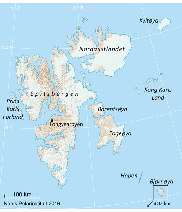
Figure 2.1 Svalbard.
Map: Norwegian Polar Institute
Most of Svalbard consists of vast and pristine wilderness areas. In all, 65 per cent of the land area and 87 per cent of the territorial sea are protected. Only seven locations are inhabited or are sites of permanent activity or industry. These locations vary greatly in character and size. Svalbard is one of the most sparsely populated areas in the world.
There are no roads between the inhabitated locations in Svalbard. Sveagruva and Ny-Ålesund have an airstrip with flight connections to and from Longyearbyen. A helicopter is stationed in Barentsburg. In winter, snowmobile travel between inhabitated locations is common, as is boat travel in summer.
Textbox 2.1 Statistics Norway’s work to strengthen official statistics regarding Svalbard
Statistics Norway has worked to develop and strengthen statistics about life and social development in Svalbard for 25 years, but the effort has been formalised and incorporated into the agency’s overall work programme with special focus since 2007, when the Statistics Act was made applicable to Svalbard.
The base of statistical data on Svalbard is growing steadily, and a number of recurrent statistical products have been created for Svalbard in isolation, or for Svalbard as a separate region in regionally compiled statistics. Statistics Norway has focused in particular on the use of registry sources that include Svalbard, so as to produce statistics comparable to those of the mainland and satisfy international standards and quality requirements. Statistics generated specifically for Svalbard include population statistics, business and industry statistics, and statistics regarding the public sector in Svalbard. From 2016, the Longyearbyen Community Council is represented with figures of its own in the Municipality-State-Reporting system (KOSTRA), which provides statistics on resource use, priorities and goal attainment. In addition, a biennial publication called This is Svalbard describes life and society in Svalbard in a broad and accessible way, using statistics as its basis. In Statistics Norway’s classification system, moreover, Svalbard is given separate treatment. All the relevant Svalbard statistics that the agency puts out are accessible at: http://www.ssb.no/svalbard.
The users of the Svalbard statistical data are to a large extent either central government administrators or local authorities in Svalbard. Others include media representatives, researchers and students. User needs are identified in large part through a consultative committee on Svalbard statistics.
Longyearbyen
As the administrative centre and hub for most activity in the archipelago, Longyearbyen is the largest inhabitated location in Svalbard. As of 1 April 2016, 2,130 people were registered as residents of Longyearbyen. In the mining and construction sectors, however, many employees commute to and from the mainland. Many of these commuters actually spend their time in Svalbard in Svea, not in Longyearbyen. The true number of Longyearbyen residents is therefore lower than the population registry suggests.
Longyearbyen was founded in 1906 by the American John M. Longyear. Its origins are tied to coal extraction from resources nearby. In 1916, Store Norske Spitsbergen Kulkompani AS (SNSK) bought the property and facilities from the Arctic Coal Company, whose main shareholder was Longyear. Until the end of the 1980s, Longyearbyen was known as a ‘company town’, dependent in practice on SNSK for everything it needed to function as a community.
Not only has the population increased since the 1980s, but it has changed in structure, evolving gradually from a male-dominated mining community into a family community.
Pursuant to Report No. 9 (1999–2000) to the Storting Svalbard, the Longyearbyen Community Council was established on 1 January 2002. The council’s responsibilities and tasks can be compared in broad terms to those of a municipality on the mainland, and its jurisdiction is limited to the Longyearbyen planning area. Section 31 of the Svalbard Act specifies that the Longyearbyen Community Council may only engage in activities of general interest related to Longyearbyen and not addressed by the state. In addition, the statement of purpose in Section 29 of the Svalbard Act indicates that the Longyearbyen Community Council must conduct its activities ‘within the framework of Norwegian Svalbard policy’.
From its early reliance on a single industry – coal mining – Longyearbyen’s economic base has now diversified to include a variety of activities in tourism and education and research. The clear and generally held view of Longyearbyen today is that of a well-developed, well-functioning and forward-looking community.
Ny-Ålesund
With its location on Kongsfjorden, about 100 km north of Longyearbyen, Ny-Ålesund is the northernmost inhabitated location in Svalbard. As of 1 September 2015 it had 43 year-round residents. Of these, 25 are employed at Kings Bay AS and five are employed by the Norwegian Polar Institute. The rest consist of researchers from various foreign institutions. The size of the population grows considerably in the summer, when scientists arrive from the mainland and abroad.
Ny-Ålesund traces its origin to coal mining by Kings Bay Kull Co. AS, founded in 1916. The company’s headquarters were in Ålesund, from which the name Ny-Ålesund is derived. The company was at first privately owned, but in 1933 the state took over all the company’s shares, and thus ownership of the real property and other assets. Mining was discontinued in 1962 after a major accident. Since 1965 the site has been a research community with infrastructure operated in large part by the state-owned company Kings Bay AS.
Ny-Ålesund is a research community. Medical care is among the dedicated services it lacks so, if the need arises, the hospital in Longyearbyen is used. Considering the community’s size and location, the infrastructure is good, and includes a quay and an airstrip.
Another aspect of life in Ny-Ålesund is ‘radio silence’, among whose beneficiaries are researchers and their use of passive receiving equipment. The place also has the world’s northernmost post office and its own store. The surrounding area features a large number of cultural heritage sites related to mining operations and to the period when the location served as a base for several expeditions to the North Pole.
Sveagruva
Sveagruva (hereafter referred to as Svea), which is situated at the inner reach of Van Mijenfjorden, was established in 1917 by the Swedish company AB Spetsbergens Svenska Kolfält. In 1934, the property and mining works were purchased by SNSK. Since then, at irregular intervals and with varying results, SNSK has had operations in Svea. During some periods, only a security team has been present at the site.
In 2000, operations at Svea Vest were discontinued, and since 2002 there have been regular operations in the Svea Nord mine, the largest in Svalbard. Production at Svea Nord was to be discontinued in the spring of 2016. According to plan, operations at Lunckefjell were to continue, but because of low coal prices operations at Lunckefjell and the rest of the mining works at Svea were placed in suspension for up to three years from 2017.
Svea is exclusively industrial, with employees commuting to and from Longyearbyen, mostly by air. Transport of all goods occurs by boat or, in winter, by tracked vehicle from Longyearbyen.
The University Centre in Svalbard (UNIS) has for many years used Svea for research and education in the field of Arctic technology, with SINTEF as a partner.
In the summer of 2015, the state purchased the real property and buildings in Svea from SNSK.
Barentsburg
Barentsburg is situated on the fjord known as Grønfjorden. The Trust Arktikugol mining company owns most of the land in the planning area and operates a coal mine at the site. Coal production is currently about 100,000 tonnes per year. As of March 2016, 450 residents were registered in Barentsburg. The community is organised on the model of a company town.
Barentsburg changed ownership several times in the early 1900s, but has since 1932 been owned by Trust Arktikugol. The name Barentsburg stems from the period of Dutch ownership and refers to the discoverer of Svalbard, Willem Barents.
In recent years, tourism and research have emerged as new activities in addition to mining. The Russian Academy of Sciences has long had a research centre on this site, and new research infrastructure has been established. Many of the buildings, including the community’s cultural centre, hotel, hospital and several residential buildings, have also been rehabilitated and modernised recently.
The Russian consulate in Svalbard is located in Barentsburg.
Pyramiden
The former mining town of Pyramiden is located in Billefjorden. The place is named for the pyramid-shaped mountain close by. It was originally established by a Swedish company, but was later taken over by Trust Arktikugol, which is also the site’s landowner. Pyramiden was abandoned as a mining community in 1998. For a number of years it stood more or less abandoned.
At one time Pyramiden had the same amenities and services as those found in Barentsburg. In recent years Trust Arktikugol has cleaned up the place and upgraded it with a view to, among other things, using it for tourism. The hotel is currently staffed and kept open at certain times of the year.
Hornsund
Hornsund is a fjord in Sør-Spitsbergen National Park, and in the 1950s a Polish research station was constructed at Isbjørnhamna on the north side of the fjord. In connection with the International Geophysical Year in 1957–1958, the station was upgraded and expanded. There has been year-round activity at the station since 1978, under the auspices of the Institute of Geophysics at the Polish Academy of Sciences. The number of researchers on site varies, but averages about 17 people throughout the year, and there is a permanent year-round staff of 11.
Bjørnøya and Hopen
The islands of Bjørnøya and Hopen each have their own meteorological station with permanent, year-round personnel. Both Bjørnøya and Hopen and their adjacent territorial sea are protected as nature reserves.
Geographically, Bjørnøya is situated almost exactly midway between the mainland and the southern tip of Spitsbergen island. Bjørnøya occupies about 178 km2. The island’s history is tied to hunting and trapping, but also attempted mining. Bjørnøya is especially known for its large and important bird-nesting cliffs. Since 1932 the Norwegian Meteorological Institute has operated a radio station and conducted meteorological observations on the island. The station has a staff of about 10, the members of which are replaced twice a year.
Hopen is a long, narrow island that juts out of the sea about 100 km southeast of Edgeøya. The island has an area of 47 km2 and its history is closely linked to hunting and trapping, but also to research. The meteorological station was established in 1947 and its on-site staff is composed of four people. As with the station on Bjørnøya, the personnel are replaced twice a year.
Other places with regular activity
In addition to the places and activities mentioned above, a number of hunting and trapping stations are still operating in Svalbard. Hunting and trapping while wintering in Svalbard was once an extensive industry, but today only a few trappers are left. One can generally figure on four such stations in Svalbard: Akseløya in Van Mijenfjorden, Kapp Wijk in Isfjorden, Farmhamna in Forlandsundet and Austfjordneset in Wijdefjorden. The first three are still in private ownership, while Austfjordneset is now owned by the state and is lent out by the Governor of Svalbard.
The age and history of these trapping stations vary, but the activity itself has a long tradition in Svalbard. It is in any case an activity that has always had to adapt to both natural and market conditions. Production and mortality for harvestable species vary from area to area and from year to year. Quotas must therefore be based on sound knowledge of the stocks and on annual counts of reindeer in relevant areas. Within these limits, hunting and trapping activity can help supply food service establishments, among others. The synergy thus created is positive, helping preserve the trapping tradition while producing useful products for other actors in Svalbard. The Government will therefore accommodate the continuation of such practices as part of the activity in Svalbard.