6 Risk reduction and natural hazard management
The Government:
Will appoint a committee to evaluate the current legislation and as appropriate make proposals for amendments to provide a better framework for the municipalities, which will have to deal with increasing volumes of stormwater as a result of climate change.
Climate change adaptation is often considered through a sectoral lens. To gain an overall picture of responsibilities for dealing with climate change, it is important to use a different starting point: the types of phenomena and events on which climate change is expected to have a strong influence. In Norway’s case, the main problems are expected to be water-related – in particular flooding, landslides and avalanches, stormwater and sea level rise.
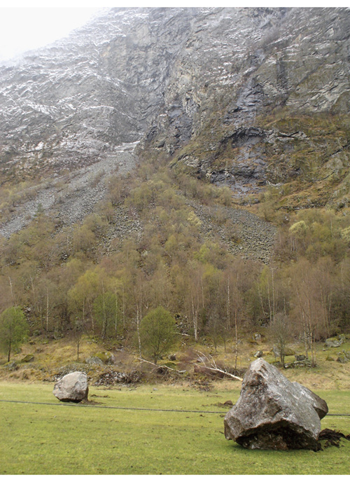
Figure 6.1 Results of a rockfall in Lærdal in Western Norway
Photo: Directorate for Civil Protection and Emergency Planning
6.1 Civil protection and emergency planning
The purpose of civil protection and emergency planning work is to safeguard life, health and property against various kinds of risks and threats. Climate change will alter the level and nature of the risks we face in a number of ways. More frequent and more intense extreme weather events, changes in patterns of flooding, landslides and avalanches, and a greater risk of forest fire in certain parts of the country will make it necessary to improve risk reduction and emergency planning. It is therefore essential for a safe and secure society that the changing climate is taken into account in this work. A white paper on civil protection published in 2012 (Meld. St. 29 (2011–2012) Samfunnssikkerhet, in Norwegian only) is intended to strengthen efforts in this field. The Government is also taking steps to ensure that efforts to boost Norway’s risk reduction capacity and capacity to manage extreme weather events are incorporated into overall civil protection work.
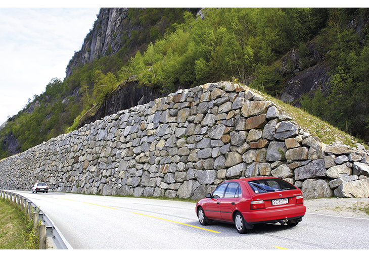
Figure 6.2 Rockfall barrier along a road
Photo: Espen Bratlie/Samfoto/NTBscanpix
Extreme weather events pose a risk to life and health and may disrupt critical infrastructure, for example electricity and transport infrastructure. And disruption of critical infrastructure such as roads, telephone systems and the electricity supply system may in itself be a threat to life and health. The projected rise in precipitation and more intense precipitation events may alter the nature and level of the risks people face. Types of flooding and slides that people in Norway are not accustomed to may become more common, for example pluvial (rain-related) flooding. Changes in precipitation and flooding patterns may entail a risk of flooding and slides in areas that have not previously experienced such events.
In the 2012 edition of the annual national risk review published by the Directorate for Civil Protection and Emergency Planning, the risk of natural hazard events such as flooding associated with extreme weather events is assessed as high in Norway.1 Climate change is expected to reinforce this picture. The Directorate emphasises that the consequences of different types of climate-related events will depend on how well Norway is prepared. The review highlights steps to make infrastructure more resilient and strengthen early warning systems as important ways of reducing loss and damage. There are close links between the preventive aspect of civil protection and climate change adaptation.
Division of responsibilities
A variety of tools and instruments can be used in civil protection and emergency planning work. In Norway, this work is based on the principle that those responsible for a particular field under normal circumstances are also responsible for dealing with crises; the principle of subsidiarity (meaning that crises should be dealt with at the lowest possible administrative level); and the principle that the organisational structures set up to deal with crises should be as similar as possible to those used in normal circumstances. In the 2012 white paper on civil protection, the Government introduced a fourth principle, that crisis management must also be based on cooperation. This was intended to clarify the Government’s overall responsibility for civil protection and emergency planning across sectors. In accordance with these principles, civil protection and emergency planning is an integral part of the work of all sectors in Norway. The authorities in each sector are therefore required to develop their own civil protection and emergency plans and instruments for their area of responsibility, and that the municipalities have overall responsibility for civil protection and emergency planning at local level.
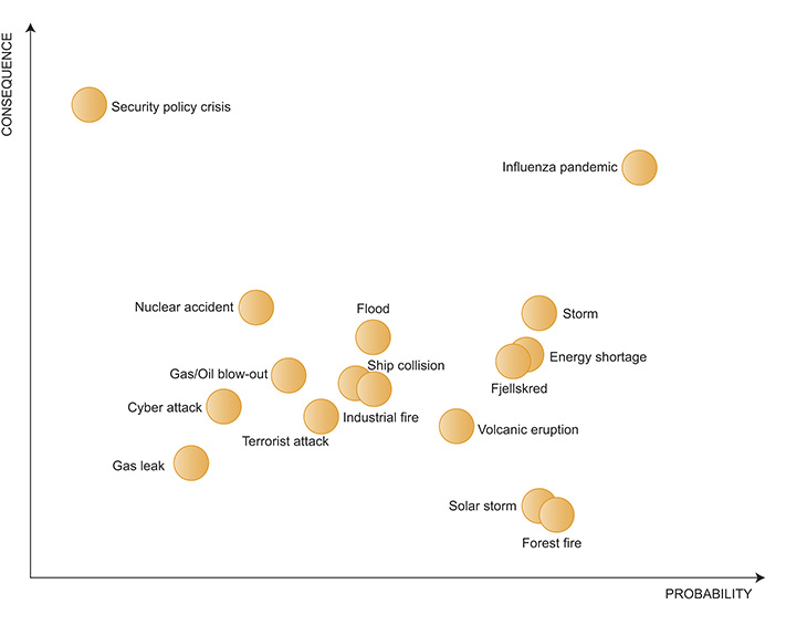
Figure 6.3 Risk matrix showing the probability and consequences of particularly serious events, from the 2012 edition of the national risk review for Norway
Source Nasjonalt risikobilde 2012, Directorate for Civil Protection and Emergency Planning (National Risk Review for Norway, in Norwegian only)
The Ministry of Justice and Public Security has the overall responsibility for ensuring policy coherence in the field of civil protection. In addition to initiating and carrying out measures, the Ministry takes initiatives vis-à-vis other government agencies and is responsible for coordinating policy and for performance monitoring in all sectors. The Ministry is also responsible for contributing to close international cooperation.
The Directorate for Civil Protection and Emergency Planning is the competent authority under the Ministry, and maintains an overview of risk and vulnerability in Norway. The Directorate has the overall responsibility for coordinating risk reduction and natural hazard management. Norway’s national platform for disaster risk reduction was established in 2011as a forum for cooperation between bodies that have responsibilities relating to natural hazards and natural hazard events. One of its tasks will be to improve the risk overview for Norway by developing more scenarios, analysing trends and generating more knowledge about vulnerability. The establishment of the national platform was also an important step in following up Norway’s commitments under the International Strategy for Disaster Reduction.
The Norwegian Civil Defence is the most important resource that can be deployed to give operational support during emergencies. Its responsibilities include many types of climate-related events, and it is an important part of the emergency services in this area. For example, the Civil Defence is used to reinforce municipal resources for fighting forest fires.
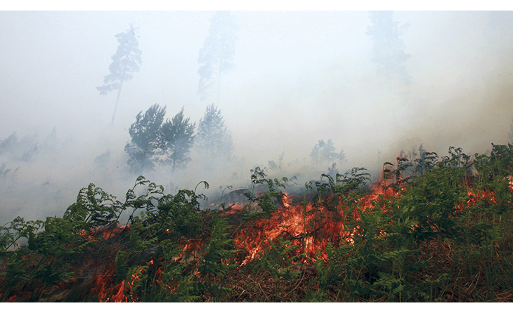
Figure 6.4 From a major forest fire in Froland, Aust-Agder county
Photo: Nicolai Prebensen/VG/NTBscanpix
After major natural hazard events, extensive clean-up may be needed. In special cases, expertise and construction resources can be obtained through the Council for Emergency Preparedness in the Construction Sector, which is appointed by the Ministry of Trade and Industry.
Civil protection in municipal planning processes
Norway’s Civil Protection Act sets out the duties of the municipalities in the field of emergency preparedness, and is designed to ensure that civil protection and emergency planning are incorporated into general planning processes and in connection with specific planning proposals. Under the Act, municipalities are required to carry out an overall risk and vulnerability analysis. This must identify the types of incidents or emergencies that may arise, including impacts of climate change. The analysis must be followed up by the preparation of an overall emergency plan for the municipality, and exercises must be held to test the system. Emergency plans must include an overview of the measures the municipality has implemented for crisis management.
Textbox 6.1 Goals for civil protection
Norwegian society has to deal with a varied and complex set of risks and threats. The Government’s goal for civil protection is to provide the population with a strong sense of safety and security by:
effectively reducing the risk of and if possible preventing incidents that may threaten life, health, key assets, functions of the public authorities or other critical societal functions;
ensuring effective emergency planning and the necessary response capacity to deal with serious crime, emergencies and accidents;
ensuring the capacity to restore critical societal functions quickly if it is not possible to prevent an incident or emergency;
ensuring that lessons are learned from incidents and exercises.
Source Meld. St. 29 (2011–2012) Samfunnssikkerhet (2012 white paper on civil protection, in Norwegian only)
Thus the importance of incorporating climate change considerations into municipal civil protection and emergency planning work, in line with other considerations of civil protection, is strongly emphasised in Norway.
The county governors are the supervisory authorities and ensure that the municipalities comply with their emergency preparedness duties. They are also responsible for coordinating civil protection and emergency planning and maintaining an overview of risks and vulnerability at county level, and function as contact points and receive reports in the event of incidents and emergencies.
6.2 Stormwater management
Stormwater means runoff on impermeable surfaces such as roofs and roads that originates from precipitation, a storm surge or meltwater. Climate projections indicate a trend towards more, and more intense, precipitation in Norway, which will result in more stormwater runoff in urban areas and may lead to urban flooding. This may cause serious damage to buildings and other infrastructure and entail a threat to life and health. The report Adapting to a changing climate (NOU 2010: 10) stresses that climate change, with higher total precipitation and more frequent intense precipitation events, will make stormwater management a more challenging task.
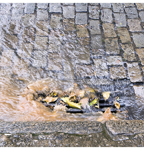
Figure 6.5 A street drain
Source Milich Zoran/Masterfile/NTBscanpix
Urban sewer systems are not generally designed to cope with large volumes of stormwater. Norway follows the principle that stormwater should be managed by infiltration into the ground, and this is a statutory requirement in the Water Resources Act. According to section 7, land should as a general rule be built up or otherwise developed in such a way that precipitation can continue to drain away by infiltration into the ground. The greater the permeability of the surface, and the greater the porosity of the soil, the greater the infiltration capacity of an area. Urban areas contain a high proportion of impermeable surfaces – for example car parks, roads, yards and footpaths – that prevent stormwater from infiltrating naturally into the ground. Urban stormwater is therefore largely channelled through the municipal sewer system, either in separate stormwater drains that may discharge directly into nearby river systems, or via the sewer systems for waste water, which discharge to waste water treatment plants. During intense rainfall, the volume of stormwater entering the sewer system is often so high that some of the mixed stormwater and waste water has to be discharged directly to the sea or a river system instead of being treated first. This can contaminate bathing beaches and drinking water and pose a risk to public health and the environment. Excessive volumes of stormwater can also flood buildings, damage infrastructure and seep into drinking water pipelines, resulting in substantial costs and possibly threatening life and health. Failure to manage stormwater properly through the existing sewer systems is already resulting in major damage.
Textbox 6.2 Norwegian Water’s views on stormwater management
Stormwater can be managed through source control or channelled through the sewer system. Source control makes use of natural soil infiltration or drainage via open waterways and ponds. Developments involving large areas of impermeable surfaces and rapid drainage via storm drains tend to intensify flooding in river systems, which can cause more damage further downstream.
Integrated planning and management of urban river systems and stormwater is needed. This approach requires close links between stormwater management and land-use and landscape planning. The most usual, and conventional, approach is to drain surface water rapidly into underground storm drains and sewers, which convey the water away. For many years, stormwater has been viewed merely as a problem, but it can also be seen as a recreational resource and a positive element of the local environment. Conventional solutions have not always functioned satisfactorily and can be expensive. Moreover, there has been a substantial rise in insurance payouts for flood damage to buildings and other infrastructure.
Norwegian Water is an association of drinking water suppliers and wastewater works in Norway.
Source Norwegian Water Report No. 162/2008 Veiledning i klimatilpasset overvannshåndtering (Climate-resilient stormwater management)
The damage is caused when sewer systems receive far greater volumes of stormwater than those they are designed for. Stormwater volumes have risen considerably, both because of increasing precipitation intensity and because the loss of green structures, expansion of impermeable surfaces and general densification in urban areas means that natural infiltration into the ground is no longer sufficient to remove the surface water. Climate change will exacerbate these problems and make it even more important to find good systems for stormwater management.
The intensity of precipitation and the severity of flooding and storm surges is expected to increase. To prevent this from resulting in stormwater damage, the municipalities need a framework that enables them to manage stormwater at source to a greater degree, in other words without it entering the sewer system. This consideration should be taken into account both in municipal planning processes and for existing built-up areas. A wide range of source control measures may be appropriate:
To increase the proportion of stormwater that infiltrates the ground, it may be necessary to reduce the area of impermeable surfaces and expand green structures, or ensure that water is drained to local streams and rivers.
Green roofs and green walls can be established to retain water.
Drains, gullies, screens and other part of the drainage system for removing water from roads must be properly maintained.
Retention ponds and rain gardens can be established for temporary water storage.
Parts of culverted streams and rivers can be re-opened.
Key legislation
Stormwater management is a municipal responsibility. However, several different authorities administer the legislation and determine the framework for municipal stormwater management in urban areas. The most important legislation is described below.
The Planning and Building Act is the most important tool for the municipalities in their efforts to ensure that land use plans and individual building projects take into account the need to manage increasing volumes of stormwater. The Act is divided into two parts: the Ministry of the Environment is the administrative authority for the planning part, while the Ministry of Local Government and Regional Development is responsible for the part on building matters. The Regulations on technical requirements for building works under the Act set out various requirements that developers must meet: for example concerning local infiltration of stormwater and maintenance of drainage systems, protection against natural hazards, upgrading and maintenance of water supply and sewerage systems and requirements for resolving water seepage problems between neighbours. As a general rule, these provisions apply to new building projects and substantial modification of existing buildings. The Norwegian Building Authority administers the regulations on behalf of the Ministry of Local Government and Regional Development.
The Water Resources Act includes provisions on the flow of water in river systems and infiltration into the ground. Section 7 of the Act states that when land is built up or otherwise developed, this should as a general rule be done in such a way that precipitation can continue to drain away by infiltration into the ground. The water resources authorities (the municipalities) may order measures to improve infiltration into the ground provided that this can be done without unreasonable costs. The Norwegian Water Resources and Energy Directorate administers the Water Resources Act on behalf of the Ministry of Petroleum and Energy.
The Pollution Control Act sets out provisions on pollution from waste water, and there are more detailed rules in the Pollution Regulations under the Act. These implement the EU Urban Waste Water Directive, which has been incorporated into the EEA Agreement. There are different requirements for discharges of municipal waste water from larger urban areas, where the county governor is the pollution control authority, and for smaller urban areas, where the municipality is the competent authority. These provisions are also relevant to stormwater management, since requirements for the design capacity of sewer systems, storm drains and waste water treatment plants depend on the quantity of stormwater entering the system. The Climate and Pollution Agency administers the Pollution Control Act and Pollution Regulations on behalf of the Ministry of the Environment. The Agency also administers the Act relating to municipal water supply and sewerage systems, which together with the relevant provisions of the Pollution Regulations provides the legal authority for the municipalities to finance water supply and sewerage systems through fees paid by customers. The water and waste water fees may not exceed the necessary costs incurred by the municipalities in these sectors. If stormwater is transported through the sewer system, the municipality may also include these costs in the fees.
Municipal planning processes
The Planning and Building Act provides the municipalities with the authority to set a framework for sound stormwater management in planning processes and for new developments in urban areas. Municipalities should draw up overall strategies for stormwater management in such areas. Projected climate change and the accompanying increase in precipitation will make this even more important. A stormwater management strategy should give an account of expected precipitation and runoff, evaluate the acceptable level of flood risk, and identify priority steps towards sustainable stormwater management. Key elements of the strategy should then be into the land-use element of the municipal master plan. This will make it possible for municipalities to include sound stormwater management as a factor in preparations for zoning plans and in individual decisions on building matters. In this context, Chapter 7 on climate-resilient municipalities and the policy instruments discussed there are also relevant.
The Government considers it important for the municipalities to make use of the authority provided Planning and Building Act and the Regulations on technical requirements for building works to plan and lay down requirements for sustainable stormwater management.
Improving the framework for stormwater management
In connection with the consultation process on the report Adapting to a changing climate (NOU 2010: 10), the municipalities pointed to a need for clearer rules and a better framework for municipal stormwater management, particularly in already built-up areas.
As mentioned above, the Planning and Building Act and the Regulations on technical requirements for building works primarily authorise the municipalities to include stormwater management as a consideration in land-use planning processes and when processing applications for new developments. However, it must be considered whether these rules for new developments need to be strengthened so that the municipalities have wider powers to set requirements for stormwater management. The municipalities’ authority to order measures to improve infiltration into the ground under section 7 of the Water Resources Act is also mainly intended to be used in connection with land-use planning (zoning plans and building development plans).
Thus, the current legislation only gives the municipalities limited authority to require changes in stormwater management in existing built-up areas – which could include replacing impermeable surfaces such as asphalt with porous materials, channelling water to streams or to areas where natural infiltration can take place, re-opening parts of culverted rivers and streams, or establishing green roofs. Further consideration should be given to widening the municipalities’ powers to require improvements to stormwater management in existing built-up areas.
At present, the rules on municipal water supply and waste water fees limit the possibilities for financing stormwater management measures through these fees. Fees may only be imposed if stormwater is channelled through municipal sewers and pipelines. Changes to the rules should be considered, including how the criteria for imposing fees should be formulated.
During the consultation process on the report Adapting to a changing climate, a number of organisations also identified a need to clarify the duties and responsibilities of the municipalities in their capacity as providers of waste water treatment services, and what residents are entitled to expect. This also raises the question of whether clearer guidelines are needed for determining which conditions the municipalities may impose on residents.
In future, increasing volumes of stormwater will also make it necessary to consider pollution from different types of stormwater, and what the implications may be for the provisions on waste water in the pollution control legislation. For example, it may be necessary to amend requirements for treatment of stormwater, design specifications for sewers, define waste water to distinguish it from unpolluted surface water, or alter guidelines or amend other parts of the legislation.
In the Government’s view, the changing climate, accompanied by increasingly intense precipitation events and more severe flooding and storm surges, makes it essential to provide the municipalities with a sound legislative framework that will enable them to prevent stormwater damage in urban areas.
As described above, the current framework includes legislation in several areas, which needs to be considered as a whole and has major implications for a range of interest groups. This field involves complex issues, and evaluating them requires specific expertise.
The Government therefore considers it important to ensure that the different interest groups are involved in an evaluation of the current framework and whether the legislation needs to be amended. To ensure that this is a thorough, inclusive process, the Government will appoint a committee to evaluate the legislation and key parts of the framework for effective municipal stormwater management.
6.3 Flooding, landslides and avalanches
Flooding, landslides and avalanches are natural processes that are influenced by the climate and thus by climate change. The Government’s aim is to improve Norway’s ability to reduce the risks posed by these phenomena. Work is in progress to identify hazard zones, avoid developments in these zones, and protect buildings and settlements at risk. This was described in more detail in a 2012 white paper on flooding, landslides and avalanches (Meld. St. 15 (2011–2012) Hvordan leve med farene – om flom og skred, in Norwegian only).
The consequences of flooding, landslides and avalanches may become worse with climate change, since these events are expected to occur more frequently, become more severe and occur in other areas than today. Climate projections indicate that episodes of locally intense precipitation will occur more frequently. This will cause particular problems in small, steep river valleys and in urban areas, where there are large areas of impermeable surfaces. Rising temperatures and a general rise in precipitation will result in changes in patterns of flooding, see Chapter 2.2. Current climate projections indicate that in some areas the size of floods will rise by more than 20 %. Sea level will probably rise, resulting in higher storm surges. This will directly affect areas close to the sea, and the consequences of flooding will become more severe near river mouths.
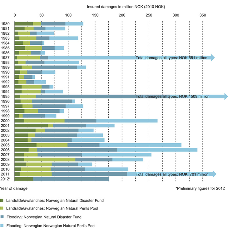
Figure 6.6 Monetary value of damages related to flooding, landslides and avalanches registered in Norway from 1980 to 2012.
Source Norwegian Natural Disaster Fund/Norwegian Natural Perils Pool
Mapping of current flood hazard shows that there are 22 000 residents and 7500 buildings in areas exposed to a 1 in 200-year risk of flooding, with the largest numbers of both people and buildings in Hedmark and Buskerud counties. These figures are based on areas that have already been mapped. In addition, there will be residents and buildings in flood-prone areas where the flood risk has not yet been mapped.
Landslides and avalanches are often triggered by meteorological conditions, and both avalanches and soil slides may be caused by extreme weather events. There are clear links between precipitation, temperature and wind conditions and different types of avalanches. Higher temperatures will reduce the risk of dry snow avalanches at altitudes below 500–1000 metres, but will increase the risk of wet snow avalanches and slush flows. A higher frequency of intense precipitation events will increase the risk of landslides and flood-related debris flows. Quick clay slides are often triggered by human activity, but may also be triggered by prolonged heavy rain and high water flow. Changes in precipitation patterns may increase the risk of debris flows and slush flows in areas that have not been at risk previously. The vulnerability of an area to landslides and avalanches depends on the infrastructure, buildings and types of buildings within it. The siting of residential buildings and other infrastructure, the choice of building type, control and enforcement routines, and maintenance are all very important issues in areas where there is a landslide or avalanche hazard. The risk of rockfall and avalanche susceptibility and hazard has been mapped for most municipalities in coastal and mountain areas of Western Norway and North Norway, and maps of susceptibility to quick clay slides have been produced for 70 municipalities.
At present, 72 000 people (24 000 households) live in areas that are susceptible to rockfalls and avalanches, and there are 64 000 people and 17 000 buildings in areas that are susceptible to quick clay slides.
Division of responsibilities
Many different actors are responsible for reducing the risk of damage from flooding, landslides and avalanches. Individual people are responsible for their own safety, and should take precautions on their own property, when out and about in the countryside and during other activities in areas where there is a flood, landslide or avalanche hazard.
Textbox 6.3 Landslides and avalanches can kill
Flooding, landslides and avalanches, together with storms, are the climate-related natural hazards that do most damage and are responsible for the largest numbers of deaths in Norway. Since 1900, about 1100 people have died in more than 500 registered landslides and avalanches. Of these, almost 500 people were in built-up areas, about 70 on roads, 200 were engaged in outdoor recreation and about 250 were travelling in connection with work (including military service). Avalanches have killed about 600 people in Norway since 1900.
In the first half of the 20th century, three large rockfalls in Loen and Tafjord in Western Norway triggered tsunamis in lakes and killed a total of 175 people. Quick clay slides can also kill many people. The largest quick clay slide in Norway’s recent history was in Verdal in Nord-Trøndelag in 1893, where 116 people died. Flooding causes few deaths in Norway.
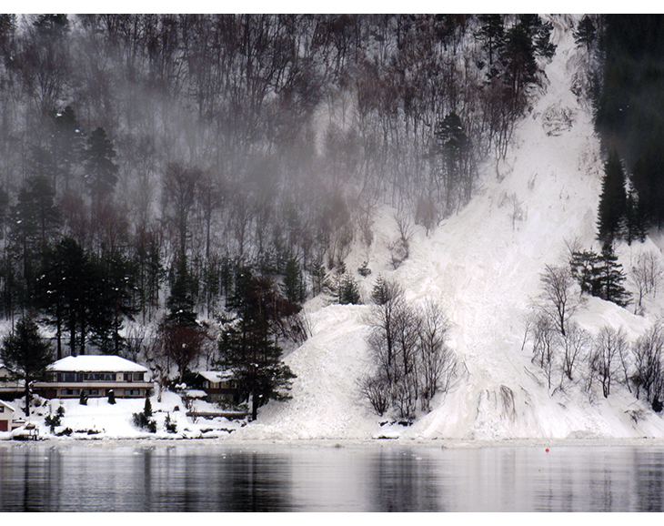
Figure 6.7 Avalanche in Western Norway
Photo: Directorate for Civil Protection and Emergency Planning
Under the Planning and Building Act, the municipalities are responsible for ensuring that natural hazards, including flood, landslide and avalanche hazards, are assessed and taken properly into account in land-use planning and processing of building applications. The municipalities also have responsibilities as the owners of land, buildings and other infrastructure such as roads and water supply and sewerage systems.
The counties are the regional planning authorities, and are responsible for drawing up the regional plans required by the Planning and Building Act. They are also major infrastructure owners – for example, they are responsible for county roads.
The Ministry of Petroleum and Energy has overall administrative responsibility for managing flood, landslide and avalanche risk in Norway. Operational responsibility for risk reduction in this field has been assigned to the Norwegian Water Resources and Energy Directorate, whose tasks include:
mapping hazard areas and providing information on them;
ensuring that flood, landslide and avalanche hazards are taken into account in municipal land-use plans;
providing the municipalities with technical and financial support for planning and carrying out risk reduction measures;
monitoring the situation and providing flood, landslide and avalanche warnings;
providing municipalities, the police and other emergency services with technical support during emergencies;
generating and spreading knowledge about flooding, landslides and avalanches.
However, every central government body has an independent responsibility for risk reduction and response to flooding, landslides and avalanches within its own sphere of responsibility, whether as the authority responsible for legislation and guidelines in a sector, as a service provider, or as the manager of its property and infrastructure.
The county governors’ responsibilities include coordinating civil protection work at county level and promoting and providing advice on civil protection and emergency planning.
Mapping flood, landslide and avalanche hazard areas
The Norwegian Water Resources and Energy Directorate is to draw up a plan for flood hazard mapping to clarify the priorities for initial mapping of new areas and for updating existing maps, and that will include all elements and levels of the mapping programme. A rolling plan is required to make it possible to incorporate new needs that arise as a result of climate change, new technology or other changes that have implications for the mapping process.
The Directorate will continue flood hazard mapping in flood-prone areas. Existing maps are to be updated on the basis of specific criteria, one of which is that rivers will be included if climate projections indicate that there will be major changes in the areas exposed to a 1 in 200-year risk of flooding in their catchments.
All municipalities should map tributaries and streams where the damage potential is high. Projections of more frequent local flooding caused by heavy rainfall and thus of a higher risk of damage along smaller rivers and streams indicate that higher priority should be given to mapping hazard areas in their catchments and for stormwater flooding. Flood hazard mapping of Norway’s smaller rivers has not received much attention so far. In addition to causing problems in urban areas, flooding in small river systems and streams can have serious consequences for the road and railway systems. Their safety is partly dependent on adequate design specifications for the very large numbers of culverts and bridges where roads and railways cross streams and small rivers.
The Water Resources and Energy Directorate will draw up guidelines for municipal mapping to ensure that sound, uniform procedures are followed. The Directorate can also provide grants for municipal mapping of river systems, within the framework of the government programme for hazard mapping. The municipalities should coordinate flood hazard mapping with mapping stormwater-related hazards and planning safe flood channels. State infrastructure owners need to maintain an overview of the status of culverts and bridges, and regularly assess the need for upgrading. Where feasible, mapping by municipalities and central government agencies should be coordinated, particularly collection and analysis of hydrological data.
The frequency of landslides and avalanches triggered by intense rainfall/flooding and snowfalls may rise in parts of Norway as a result of climate change. As in the case of flood hazard mapping, the impacts of climate change must be taken into account in landslide and avalanche hazard mapping wherever relevant, in a way that is adapted to the use of the data.
Assessing and mapping flood, landslide and avalanche hazard and risk requires a great deal of information and high-quality underlying data.
For analyses relating to flooding, landslides and avalanches, it is particularly important to have detailed topographic data that can be used as a basis for analyses of the terrain and geological structures.
The importance of municipal land-use planning
Under the Planning and Building Act, the municipalities are chiefly responsible, through their planning activities, for shaping the physical environment, maintaining its quality, and finding a balance between development and conservation on the basis of its characteristics and local factors. The importance of municipal land-use planning in natural hazards risk reduction and climate change adaptation was highlighted in a 1997 white paper on flood control and protection measures (St.meld. nr. 42 (1996–97) Tiltak mot flom, in Norwegian only), the 2012 white paper on civil protection, and the report Adapting to a changing climate (NOU 2010: 10).
The increasing flood hazard must be taken into account in land-use planning. There can be major benefits in taking an integrated approach to planning that also includes ecosystem services and species and habitats. Particular caution must be exercised along steep rivers and streams where the water may find a new course or wash out soil and debris. Maps of potential flood channels can provide a good basis for municipal mapping of high-risk areas. It is particularly important to take into account the role of wetlands in flood control, see Chapter 8.1. Mires and other wetlands store water and release it slowly, which slows down the speed of floodwater. As a general rule, mires and other wetlands should not be drained or developed. Natural riparian vegetation provides good protection against flood damage and erosion of riverbanks, and should be safeguarded in municipal land-use plans.
In its climate change adaptation strategy, the Norwegian Water Resources and Energy Directorate states that if climate projections show that flooding will increase by more than 20 % in the next 100 years, the projected figures should be used as a basis for land-use planning. This is already being implemented in practice.
The frequency of landslides and avalanches triggered by intense rainfall/flooding and snowfalls may also rise in parts of Norway. So far, little is known about how this will influence the delimitation of hazard zones for landslides and avalanches using the probability limits that are the basis for land-use planning. Even using today’s climate as a basis, the level of uncertainty associated with the delimitation of hazard zones for landslides with an annual probability of less than 1/1000 is so great that there is no reason to add an extra margin of error to take account of climate change.
In addition, it is clear that sea levels will rise. However, there will be regional variations, and in several areas the rise in sea level will be reduced by glacial rebound. In 2011, the Directorate for Civil Protection and Emergency Planning published guidelines on how to take sea level rise into account in municipal planning, in cooperation with several other agencies.
The Ministry of the Environment, in cooperation with the Ministry of Local Government and Regional Development and the Ministry of Petroleum and Energy, intends to develop recommendations or guidelines on how to include the effects of climate change on flooding, landslides and avalanches, and storm surges/sea level rise in municipal planning. Municipal plans must be based on environmental criteria designed to ensure that the natural environment and water quality are taken into account when planning and implementing climate change adaptation measures.
Flood defences and landslide/avalanche protection
When upgrading or major repairs to older flood control or landslide/avalanche protection are being planned, environmental improvements are also considered. For example, flood defences can be moved further away from river banks and closer to the buildings they are primarily intended to protect. In addition to being environmentally beneficial, this can reduce costs and the impact of the flood defences on downstream flooding.
Ideally, when selecting design specifications for flood defences or landslide/avalanche protection, it should be possible to achieve as good a level of protection for existing buildings and infrastructure as for new projects, and this also applies to adaptation to climate change. This aim will be used as the basis for planning such measures, but in practice it may often be difficult to achieve an equivalent level of protection, and the costs may be unreasonably high. As for other projects, cost-benefit analyses must be used to assess steps to protect existing buildings and other infrastructure.
The Norwegian Water Resources and Energy Directorate will draw up a manual for landslide/avalanche protection, based on established practice and experience in other countries.
Flood, landslide and avalanche warning
Climate change will involve a general increase in precipitation and more frequent episodes of locally heavy and intense rain followed by flooding in small, steep river catchments. In the longer term, it will therefore be important to establish more flow monitoring stations in such rivers. This must be combined with modelling with better time resolution to give more precise forecasts, particularly for small catchments.
Certain landslide and avalanche types are influenced by climate change, especially by higher and more intense precipitation. Norway’s 2013 budget includes an extra allocation of NOK 9 million to establish an operative forecasting service for landslides and avalanches. The avalanche forecasting service has been in operation since 14 January 2013.
Knowledge needs
In connection with the preparation of the 2012 white paper on flooding, landslides and avalanches, an assessment was made of R&D needs in this field, based on input from key research institutes and bodies in the public administration. Knowledge needs were noted in the following areas:
the climate system and hydrological and geological processes;
extreme precipitation, modelling of small catchments and urban stormwater management;
better models and calculation tools that can be used in producing warnings and in mapping flood, landslide and avalanche hazard areas;
interdisciplinary research on the impacts of flooding, landslides and avalanches, and on the design and effects of protection and risk reduction measures, including more knowledge about the role of ecosystem services in mitigating flooding, landslides and avalanches.
The research institutions also highlighted the need to give priority to improving research infrastructure.
6.4 Sea level rise
Sea level rise associated with climate change will lead to new challenges in some areas. Individuals, private companies, public bodies and local and central government authorities all have a responsibility for taking steps to safeguard their own property. Under the Planning and Building Act, the municipalities are responsible for ensuring that natural hazards are assessed and taken properly into account in spatial planning and processing of building applications. This includes the responsibility for taking sea level rise and the resulting rise in storm surge levels into account.
Advice and guidance on sea level rise and storm surges
The website Klimatilpasning.no offers advice and guidance on dealing with a rising sea level, based on a report on sea level rise with estimates of the rise expected in coastal municipalities in Norway (Havnivåstigning. Estimater av framtidig havnivåstigning i norske kystkommuner, in Norwegian only). The report, which was published in 2008 and revised in 2009, was drawn up by the Bjerknes Centre for Climate Research and the Directorate for Civil Protection and Emergency Planning. The recommendations in the report are based on projections from the Bjerknes Centre, which used calculations by the Norwegian Mapping Authority in taking glacial rebound into account. The recommendations are also based on the Fourth Assessment Report from the Intergovernmental Panel on Climate Change (IPCC), but corrected for the contribution to sea level rise from the large ice sheets in Greenland and Antarctica, which the IPCC report did not include. The risk of an increase in the rate of melting has been included in accordance with the precautionary principle, even though there is a great deal of scientific uncertainty as to how much this will contribute to sea level rise in the period up to 2100. The Dutch and British authorities, and more recently the Danish authorities, have made similar recommendations.
It is very uncertain how much and how quickly sea level will rise. Knowledge about how climate change is influencing sea level is constantly being developed, so that current information rapidly becomes outdated. Advice should therefore be updated regularly.
6.5 Compensation and insurance cover for natural hazard damage
Cover against natural hazard damage is provided in three different ways in Norway. Any property that can be insured against fire is covered by private natural hazard damage insurance, which is a mandatory part of all fire insurance policies. If it is not possible to take out normal insurance to cover the property against these risks, the Norwegian Natural Disaster Fund can provide compensation for natural hazard damage. For property that is not covered by either of these regimes, the owner carries the risk and liability, or must take out special insurance cover.
The Norwegian model, including both public and private arrangements for insurance against natural hazard damage, provides major benefits for society, since it gives effective protection against the financial risk associated with extreme weather events. This is very important for people who are directly affected by such damage.
Climate change will have implications for these insurance arrangements. More frequent and more severe extreme weather events and more intense precipitation could result in increasing damage caused by water penetrating into buildings. Higher precipitation will also worsen problems relating to building decay. Moreover, there will be a higher risk of flooding that could damage bridges, roads, forest, agricultural areas, buildings and other infrastructure.
In certain vulnerable areas that have already been built up, climate change may result in a considerable rise in the risk of damage and perhaps in higher insurance premiums and insurance payouts. If events that are considered to be extreme today become common, it may not be possible to obtain insurance cover at all. A study by the insurance company Gjensidige indicates that by the end of the present century, higher precipitation could result in a 50 % increase in the number of cases of water damage in certain counties.2
The insurance companies play an important role in reducing the economic risk borne by companies and private households. Under Norwegian legislation, insurance companies must determine insurance premiums on the basis of risk levels. This means that they can for example offer lower premiums to customers who take steps to prevent climate-related damage. In this way, they can play an important part in reducing overall damage caused by climate change.
Private insurance schemes
The private regime for insurance against natural hazard damage is regulated in the Natural Hazard Insurance Act, according to which all property that is insured against fire must also be insured against natural hazard damage. As part of this system, the insurance companies coordinate their liabilities through the Norwegian Natural Perils Pool, which settles compensation for damage caused by natural hazards between insurance companies that provide fire insurance in Norway. Membership of the Pool is mandatory for all companies that provide fire insurance in Norway. Anyone who for example takes out house insurance pays a share of the premium to the Pool: in 2012, this was 0.007 % of the amount for which the property was insured. This means that if a house is insured for NOK 1 million, the premium for natural hazard insurance is NOK 70. The rate was reduced from 0.008 to 0.007 % of the insured value from 1 January 2012 in response to a favourable long-term trend in insured losses. An excess of NOK 8000 is payable for each claim for natural hazard damage. The Norwegian Natural Perils Pool is administered by Finance Norway.
Forest owners can take out fire and/or storm damage insurance for productive forest on their properties through the company Skogbrand. This is ordinary insurance, even though compensation for fire or storm damage to forest is not covered either by the Natural Hazard Insurance Act or by the Natural Hazards Act. However, regulations under the Natural Hazards Act provide for the Norwegian Natural Disaster Fund to act as reinsurer if the total storm damage to forest exceeds NOK 200 million in a specific case. This ceiling is considered in relation to the area of forest insured as a proportion of the total area of forest in Norway. The insurance companies provide compensation for insured areas up to this relative ceiling, and the Fund provides compensation for damage in excess of this for forest owners who have insurance.
Compensation from the state for natural hazard damage
The Natural Hazards Act regulates the state compensation scheme and the responsibilities of the Norwegian Natural Disaster Fund. The Act is administered by the Ministry of Agriculture and Food, except for Chapter 3 on measures to prevent natural hazard damage, which is the responsibility of the Ministry of Petroleum and Energy.
The task of the Norwegian Natural Disaster Fund is to provide compensation for natural hazard damage in cases where insurance is not available through normal insurance arrangements. The scheme typically covers for example private roads and bridges, forest (flooding and landslide/avalanche damage), agricultural land, quays and breakwaters, sports facilities, tourism and industry.
Textbox 6.4 The most common types of natural hazard damage and insurance cover
Storms and gales – The lower limit for compensation for storm damage is a strong gale (wind speed from 20.8 m/s). Meteorological measurements are used as a basis for determining whether the wind has been so strong that the damage can be defined as storm damage.
Flooding – For flooding to trigger insurance payouts, there must be extraordinary precipitation or rapid snowmelt that results in an abnormally high water level and damaging inundation. Extraordinary levels of natural runoff that cause water to find new channels in sloping terrain will also trigger insurance payouts. It is a condition that the situation results in extraordinary damage.
Landslides and avalanches – These are the sudden movement of earth, rocks, clay, or snow in the case of avalanches. Rockfalls are also included here. Frost heave and other gradual changes in pressure in the soil are not covered by insurance, nor is settling or subsidence.
Since all fire insurance for buildings and other property in Norway includes insurance against natural hazard damage, one form of insurance is in many cases sufficient.
Anyone who is insured has a duty to take steps to prevent or limit damage. If they do not, the insurance company’s liability may be reduced or cease to apply. Similar rules for the reduction of claims apply under the state arrangements for compensation for natural hazard damage if someone has failed to take reasonable steps to prevent or limit damage.
Source Finance Norway
The Natural Hazards Act gives the injured party a statutory right to compensation under certain conditions. It is only the owner of the object or property that has been damaged who is entitled to compensation. The scheme is intended to make it possible for private landowners to restore their property after natural hazard damage, so that they can continue their activities. This is achieved through a permanent, general compensation regime with objective criteria and prescribed conditions, which gives people a predictable entitlement to a state benefit when property that cannot be insured suffers natural hazard damage. Damage to public property is not covered by the compensation scheme.
The Natural Hazards Act also contains provisions that can reduce the risk of future damage to property that has already suffered natural hazard damage. As a general rule, any compensation provided must be used to repair the damage, but the board of the Natural Disaster Fund may make it a condition for payment of compensation that this is done in a way that reduces the risk of natural hazard damage in the future. For example, if a damaged building or other structure is on a site where the risk of damage is particularly high, the board may require it to be moved to a less vulnerable site. The board may also make it a condition that compensation is used to acquire a different property outside the high-risk area. In such cases the board may require the judicial registration of a declaration that the property is at risk of natural hazard damage. An injured party may also receive a grant towards the extra costs of reducing the risk of future damage.
The third chapter of the Natural Hazards Act sets out provisions on protection against natural hazard damage, and specifies the municipalities’ rights and duties in this area. The formal responsibility for these provisions, and the corresponding budgetary funds, were transferred to the Ministry of Petroleum and Energy in 2009, when the Norwegian Water Resources and Energy Directorate was given administrative responsibility for risk reduction measures for all types of landslides and avalanches, based on the same model as that already established for flood risk management. Thus, the Norwegian Natural Disaster Fund is no longer responsible for the payment of grants for protective measures.
The Norwegian Water Resources and Energy Directorate has drawn up guidelines on assistance in assessing, planning and carrying out protective measures. The 2012 white paper on flooding, landslides and avalanches announced that the Ministry of Petroleum and Energy, as the competent authority under the provisions of the Natural Hazards Act, would carry out a complete review of responsibilities for flood control and landslide/avalanche protection, taking the provisions of the Natural Hazards Act as a starting point.
Risk reduction
Climate change may result in an increase in both the scale and the frequency of different types of natural hazard damage. This makes it appropriate to consider how the Norwegian model for natural hazard insurance can be adjusted in a way that encourages greater caution and promotes risk reduction. A higher risk of damage in itself indicates that efforts to prevent damage should be intensified. Action that is being taken includes stepping up mapping of flood, landslide and avalanche hazard and intensifying risk reduction measures, as described in the 2012 white paper. Protection measures, sound land-use planning and appropriate building techniques are all important in limiting the damage caused by natural hazards. Various planning tools are available for use in climate change adaptation, for example the flood hazard maps produced by the Norwegian Water Resources and Energy Directorate, the website skrednett.no, which provides maps and information on landslide and avalanche risk, and risk analyses.
The Norwegian Agricultural Authority reviewed the state compensation scheme for natural hazard damage in 2008.3 Climate change and the accompanying probability of increasing damage in the future were an important element of this review. The Ministry of Agriculture and Food used the report as a basis for the consultation documents published on 11 September 2009 proposing a number of amendments to the Natural Hazards Act in order to simplify it, make it more robust and ensure more rapid processing of claims for compensation. The proposals are being considered by the ministry after the consultation round.
Textbox 6.5 Climate change adaptation in the Nordic insurance industry
The Nordic insurance industry has undertaken to take action to meet the challenge of climate change by:
developing and offering climatically sustainable products within life and non-life insurance;
incorporating climate aspects into investment strategy considerations;
using climatically sustainable methods in loss prevention and claims settlement;
organising and conducting their business in climate-smart ways.
Source Finance Norway
Climate-related events may play an increasingly role in insurance payouts, and the insurance industry plays a key role in society’s response to extreme weather events. The insurance companies have detailed information on climate-related damage. This information is part of the evidence that makes it possible to state that cases of damage caused by sewage backup have risen in number and scale in recent years. This rise can be linked to climate change and observed extreme weather events.
Footnotes
Nasjonalt risikobilde 2012, Directorate for Civil Protection and Emergency Planning (National Risk Review for Norway 2012, in Norwegian only)
Orskaug, E and Haug, O (2009) Skadeprediksjoner basert på ECHAM4 klimamodelldata (Predictions of damage based on data from the ECHAM4 climate model, in Norwegian only). Technical report, NR-notat SAMBA/29/09, Norwegian Computing Center
Utredning ny naturskadelov 2008 (Proposal for a new Natural Hazards Act 2008, in Norwegian only), Norwegian Agricultural Authority