1 About Norway – population, topography and transport infrastructure
Population
Population: 5 258 317 inhabitants as of 1 January 2017
Inhabitants per sq. km land area: 17.3
Population growth rate (2016): 0.9 per cent
Norway has the lowest population density in Europe after Iceland. However, more than 80 per cent of the population live in urban areas, where the population density is 1 947 per sq. km (2016).
Mainland topography (2016)
Area (mainland): 323 781 sq. km
Length of coastline (mainland, including fjords and bays): 28 953 km
Built-up area: 2 per cent
Agriculture: 3 per cent
Marsh/wetland: 5 per cent
Freshwater and glaciers: 7 per cent
Forest: 37 per cent
Mountain and mountain plateau: 45 per cent
A large part of the country is unsuitable for settlement or agriculture due to harsh climatic conditions, poor soil quality and difficult terrain.
Transport infrastructure (2016)
Public roads, total: 94 600 km
National roads: 10 700 km
County roads: 44 500
Local roads: 39 400
Total number of road tunnels: more than 1 100
Railway network, total: 4 208 km
Electrified railway network: 2 459 km
Double railway track: 269 km
Airports with scheduled flights: 49
Seaports with connection to the national transport grid: 32
Fishing ports: 700
Broadband coverage/availability in Norway:
99.95 per cent of Norwegian households have a broadband coverage of at least 10 Mbit/s (on commercial terms).
82 per cent of Norwegian households have a broadband coverage of at least 30 Mbit/s (on commercial terms).
78 per cent of Norwegian households have a broadband coverage of at least 100 Mbit/s (on commercial terms).
Mobile broadband (4G) covers all main roads and most households in Norway.
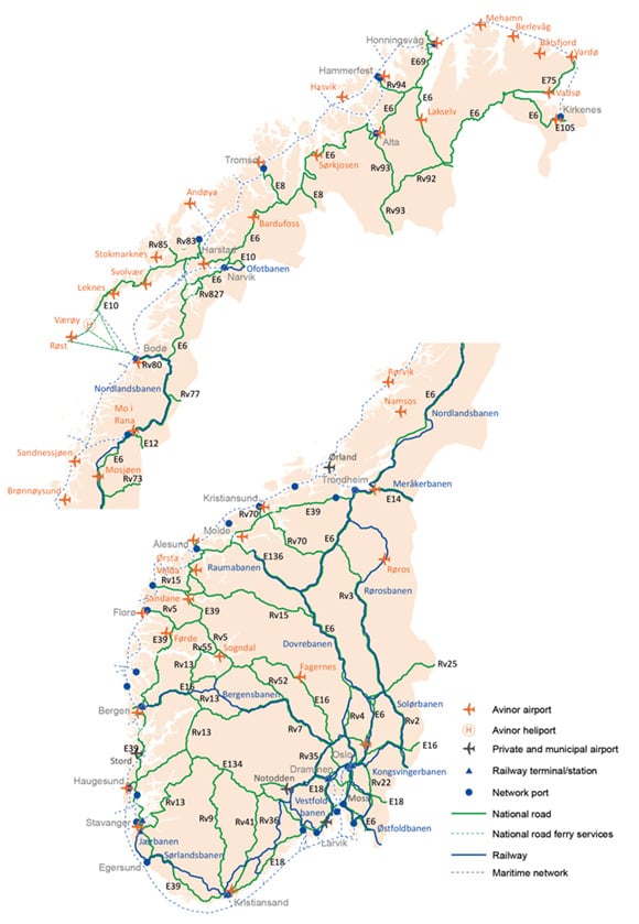
Figure 1.1 Map of national infrastructure