1 Data content
The central government and municipalities collect and manage geospatial information that represents the foundation of our national knowledge base. The information is used in various administrative procedures, but it is also included as part of various public services. Moreover, this information is the basis for the creation of value in trade and industry and benefits us all.
The municipalities are important contributors to, premise providers for and users of the knowledge base. They establish, develop, partially finance and maintain detailed geospatial data. The municipalities' administrative data capture covers most of the man-made changes to the physical environment. The Norwegian Public Base of Geospatial Data (DOK) is used to make decisions, approve applications, prepare and process plans in accordance with the Planning and Building Act and to develop local communities. Among other things, the municipalities use the data in their work with climate adaptations and to safeguard environmental considerations and conservation interests.
A good geospatial knowledge base is essential for well-functioning cities and local communities. The building industry is a billion kroner industry that can achieve greater predictability, better engineering support and more efficient interaction with the municipalities through integrated use of geospatial information.
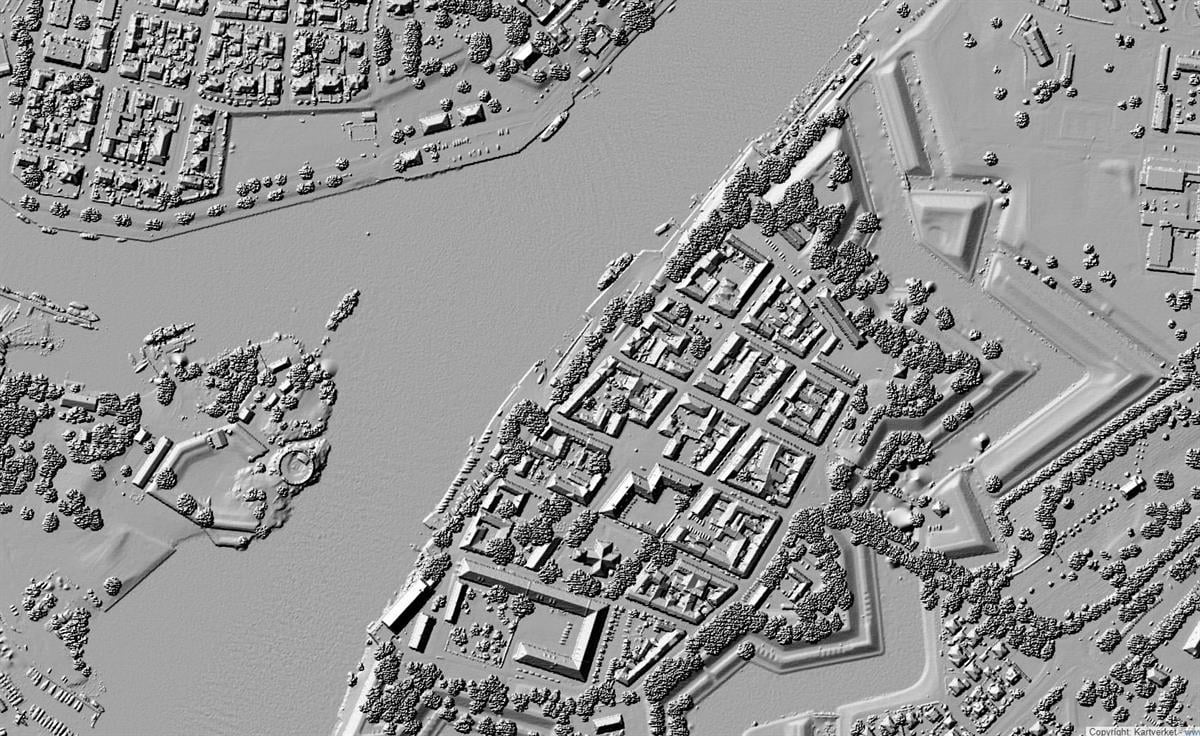
Figur 1.1 A surface model showing elevation data based on detailed laser measurements from an aircraft
Kilde: Illustration photo: Norwegian Mapping Authority, hoydedata.no
Expectations for the data content of the infrastructure are increasing
Central societal processes are becoming increasingly dependent on quality-assured data from many sources – preferably across sectors and administrative levels. The requirements for updating are increasing. In some cases, real-time data updates are required. The users’ expectations for the data content and quality are often higher than what the geospatial data infrastructure can offer. For example, the municipalities point out that they need more detailed and comprehensive data and better documentation of appropriate use than what they currently receive from national agencies in the Norwegian Public Base of Geospatial Data. In areas of society where digital geospatial information is not currently utilised much, there will be new users who request other data and levels of detail, but who will also contribute new data to the infrastructure. These needs and expectations for the data content will place pressure on the infrastructure. There will also be a need for an effort to raise the quality of the data.
Ecological base map
Good geospatial data for the environment is crucial when large and small initiatives are to be planned and realised. In order to succeed, we must have good maps showing where various natural assets are located. The Government is following up the Storting’s request to strengthen the efforts to map the natural environment and establish an ecological base map for Norway. The Ministry of Climate and Environment has appointed the Norwegian Environment Agency to lead and coordinate this work, which will take place in close cooperation with the Norwegian Biodiversity Information Centre and the affected authorities.
The ecological base map is not one specific map, but a collection of geospatial data with, among other things, geo-referenced information for the types of natural environments, species and types of landscape. Such geospatial data is available from the environmental management, scientific communities and various sectoral authorities. The sum total of this geospatial data will represent an ecological base map for Norway and provide the basis for knowledge-based management of the Norwegian natural environment.
The selected map layers shall be collated and made easily accessible as spatial services in accordance with the requirements of the Spatial Data Act. A user-friendly and up-to-date viewing solution shall also be created. As part of this effort, work is in progress to establish routines for the flow of data from various authorities and related services for the ecological base map.
The combined efforts must be utilised better
Collecting and managing data is often associated with high costs. This means that as much as possible must be gained from the combined efforts through cooperation. Central government agencies have a self-defined need for specific data within their areas of responsibility and manage their own investments accordingly. The municipalities establish data to exercise their role as a service provider and exerciser of authority, for example in the form of municipal master plans, detailed technical maps and the water grid. There is well-functioning cooperation for the coordinated establishment, management and maintenance of detailed data through cooperative structures such as Geovekst6 and the National Programme7for Aerial Photography. In the area of marine mapping, the Mareano8 Programme is a corresponding example. Cooperation is both socio-economically sensible and necessary. In addition, a number of international programmes in the area of environmental and resource monitoring also contribute a large amount of new data. It is expected that international joint initiatives will be of greater importance in the future. Copernicus, Europe’s major satellite and sensor-based programme for environmental monitoring, climate and civil protection, provides us with data on land use, vegetation changes, water quality, weather conditions, air quality, pollution and greenhouse gases. This concerns large amounts of data that are now available and must be utilised in a good way, which entails new major requirements for the infrastructure for geospatial information.
Actors outside of the public administration must participate to a greater extent
Colleges, universities, research institutions and national and international R&D programmes create data that will be valuable to decision-making processes and for the creation of value. In general, this information is currently not very accessible for reuse. It must be possible to link the geospatial data infrastructure to research data to a greater degree. Geo-referenced research data could thus become part of our common knowledge base, and the geospatial data infrastructure could support research more efficiently in accordance with the national strategy for the disclosure and sharing of research data9. This goes both ways: The geospatial data infrastructure shall be suitable as a source of data for research, and for the archiving and disclosure of geospatial related research data.
Private actors contribute to the production of data through development plans, licence applications, impact assessments, environmental assessments or other statutory interaction with central government agencies or municipalities. This data must also become an integral part of our overall knowledge base to a greater extent.
Private companies also establish databases for various special purposes, which may encompass general maps of roads, topographies, etc. Examples of major global actors who have done this include Google, Apple and the map service Here. These actors do not just use detailed basic maps and aerial images, they also use three-dimensional terrain models and various types of thematic information.
Organisations, the voluntary sector and the general public also contribute to the production of geo-referenced data, through online voluntary work and interaction with the public sector. The infrastructure shall facilitate the utilisation of these contributions in the infrastructure, as well as innovation.
Data content sub-goal
1.1 Priority geospatial data is anchored, funded and established
Some geospatial data forms the foundation for the entire infrastructure. This “core data” must be defined in more detail. The data sets must have a known coverage and be of sufficient quality to meet the intended purpose, be up to date and easily accessible. If necessary, the specific data sets must be formalised in legislation to ensure their availability and create predictability, so that automated decision-making processes can be supported. Some key data – such as property, building and address data from the land register (cadastre) – must be of very high quality, since many societal processes are dependent on this data. It will be important to develop good processes and resources for the planning, prioritisation and coordination of the actors’ data capture, maintenance and improvement of the quality of the priority data sets.
Basic geospatial data and thematic geospatial data
The United Nations Committee of Experts on Global Geospatial Information Management (UN-GGIM) points to the following themes as fundamental to society's access to geospatial information:
- reference frame for positioning
- geographical names
- addresses
- administrative and other functional areas
- buildings and settlements
- land parcels and registration of rights
- transport networks
- surface of the Earth (on land and under the sea and water)
- population distribution
- land cover and land use
- geology and soils
- physical infrastructure, including the service and utility infrastructure
- water and watercourses
- orthoimagery
The INSPIRE directive defines additional topics. The expansion here applies first and foremost to environmental information.10
In accordance with the current principles of Norway Digital, the geospatial data infrastructure consists of both basic geospatial data (seabed, topography, watercourses, geographical names, etc.) and thematic spatial data (resource information, environmental information, geology, existing and planned land use, etc.). The Norwegian Public Base of Geospatial Data currently sets out 140 spatial data themes that are of importance to purposes pursuant to the Planning and Building Act.
1.2 Geospatial information is well-adapted technically and thematically for use
The needs of the users and adaptation for a digital first choice must be key to the development of the national infrastructure. Authoritative and prioritised data shall be structured, documented and offered in accordance with the expectations and user requirements, including international requirements. Data that is included in the national infrastructure, but is not necessarily defined as part of the prioritised “core data”, shall also be adapted for use by the fulfilment of certain requirements (formats, metadata, quality labelling, etc.). Such data may have completely different qualities or coverage. Some data may be adapted to the simple needs of specific user groups, while other data may be used by more groups and subject to greater requirements. The infrastructure shall offer three-dimensional data, dynamic data, historical data and processed information. Broad utilisation of new technologies shall also be facilitated, which can make the utilisation of big data possible, among other things. There shall be a complete overview of geospatial information, including the properties and related services in the map directory www.geonorge.no.
1.3 Geospatial information collected in accordance with public requirements is available in the infrastructure
Significant amounts of geospatial information are collected through publicly funded mapping programmes and research activities at universities, colleges, museums and institutes – and as part of the public development activities, projects and consulting assignments. Through a number of laws, regulations and rules, both private and public actors are required to prepare documentation in the form of geospatial information, in connection with licence applications, spatial planning and building applications, etc. This data represents a potential value to the overall source data. However, to ensure further management and utilisation of the data, the various actors must be aware of the relevant requirements and ensure that the data is made available through the national infrastructure. The infrastructure must be adapted at the same time to this data content.
1.4 Society has appropriate reference frames for positioning
Accurate navigation and positioning services are becoming increasingly important for the utilisation of geospatial information. A necessary prerequisite for this is to have appropriate reference frames for the positioning that enable the users to determine geospatial coordinates (for example, latitude and longitude) with an adequate degree of accuracy and reliability (geodetic reference frame). There is a need for continuous control and updating of this reference frame. The best possible positioning services shall be offered for all applications, based on international guidelines for a sustainable global geodetic reference frame. Increased accuracy requirements require corresponding improvements in the reference frame.
1.5 Infrastructure simplifies reporting for the national, European and global needs
The Norwegian geospatial data infrastructure shall observe the principles that are inherent to work on the geospatial data infrastructure in the EU, including, for example, that data shall only be collected once, that it shall be stored where it can be the most effective, and that it shall be possible to combine the data seamlessly between different application areas.
Reporting is often fragmented and the opportunities for digital, efficient data capture, adaptation and distribution through sharing on digital platforms are not utilised to any great degree. The national geospatial data infrastructure shall supply various parts of the public sector with relevant data, and it shall also support coordinated and efficient sharing and reporting of Norwegian data for international purposes.
1.6 As a rule, the infrastructure shall be based on open data
The requirements in and pursuant to the Spatial Data Act govern access to data in the geospatial data infrastructure. This applies, for example, to the requirements for documentation and open electronic access. Other laws and regulations also set out requirements for open data, such as the Freedom of Information Act and Environmental Information Act. The Ministry of Local Government and Modernisation’s guidelines11 for the disclosure of public data apply to data in the geospatial data infrastructure. This implies essentially that the data is free and freely available for reuse. There are some exceptions, including the most detailed geospatial data (Joint Geospatial Database, “FKB”) and precise position data, for example. These are areas where the collection and management of data are particularly costly or where user financing can contribute to better resource allocation. A report on the value of free geospatial and property data from Vista Analyse (“Verdien av gratis kart- og eiendomsdata”, 2014) accounts for the social importance of simple and free access to geospatial and property data.
The Ministry of Local Government and Modernisation’s aim is for national geospatial and property data to be made available for self-service over the Internet for searching, viewing and downloading, and to be freely available in line with other public information. As a rule, data that is directly associated with retrieval costs shall have a price that covers the cost of distribution. This includes maps and documents on paper, DVD and other physical media. This also applies to retrieval that requires manual processing or other forms of access control. The electronic services shall be adapted to the needs of the general public, trade and industry, and the public administration.
There will still need to be restrictions on access to geospatial and property data for the sake of privacy and national security. Other exceptions may also apply to the need to protect threatened animal species, for example. Changes in the pricing policy will occur incrementally within the current budget limits at any given time.
Species sightings
The website artsobservasjoner.no is a major voluntary knowledge sharing effort that involves the general public mapping species in Norway. Through this service, volunteer amateurs, consulting firms and the public administration contribute to increasing knowledge of what species exist in Norway and where they are located.
Artsobservasjoner.no is being developed and operated by the Norwegian Biodiversity Information Centre on behalf of the Ministry of Climate and Environment. The system was established in 2008 and now contains over 19 million sightings of species across all the species categories. Data from the solution is used daily in public administration and research, as communicated through the Species Map service.
1.7 Data from the general public is used where appropriate
Online voluntary work and other forms of data collection from the general public represents a potential for supplementary access to data. The infrastructure already has a couple of examples of data from the general public, such as data on trails and paths, but this can be supported better than it is at present. Standards for data capture, quality labelling and modelling must also be in place, so that the public administration can fully benefit from this type of data.