3 Commercial activities in the northern part of the management plan area
3.1 Introduction
Human activity has less direct influence on the Arctic part of the Barents Sea–Lofoten management plan area than on any other part of Norway’s marine areas. However, changes in ice conditions are making more of the area accessible to various activities, and larger areas are also becoming accessible as a result of technological advances. Patterns of activity are therefore expected to change. This will make new demands on the management of the most northerly areas.
Fisheries, maritime transport and petroleum activities are the most important activities in the area. In this chapter, actual fisheries activities are discussed in the section on fisheries, while fishing vessels are dealt with in the section on maritime transport. Statistics on maritime traffic in the northern part of the management plan area concern traffic north of the boundary of Arctic waters as defined in the IMO Polar Code. The chapter also contains a section dealing with the risk of acute pollution and the special challenges relating to oil spill preparedness and response in icy waters.
Textbox 3.1 Research on the environmental impacts of new commercial activities in the north
In 2014, a new flagship research programme, ‘Environmental impacts of industrial activity in the north’ (MIKON) was started up at the Fram Centre in Tromsø. The programme is intended to strengthen the knowledge base for the authorities’ efforts to limit the ‘footprint’ of industrial activity in north, and to ensure that new industrial activity takes place within a sound environmental framework. Research takes into consideration both existing activities and new developments that are expected in the future.
Given developments in the High North, including a growing volume of maritime transport and expansion of resource extraction activities, Norway must maintain a presence and exercise its sovereignty in the region. Norway’s interests and particular responsibilities in the High North also require military capacity. The functions of the Coast Guard and satisfactory search and rescue capacity are particularly important in this connection. The main function of the Coast Guard is to exercise sovereignty and authority, and operations in northern waters are given priority.
3.2 Fisheries
There is a long tradition of large-scale fisheries in Norway’s northern sea areas. In the Barents Sea and the northern part of the Norwegian Sea, both Norwegian and foreign vessels harvest from large stocks of Northeast Arctic cod, haddock and saithe, capelin and Norwegian spring-spawning herring, and shellfish such as prawns.
Norway has a modern, efficient ocean-going fishing fleet that operates both off the mainland coast and in the northern seas. Purse seiners and pelagic trawlers fish Norwegian spring-spawning herring along the coast in autumn and winter, and target the capelin stock when it moves to the spawning grounds along the coast of Finnmark in winter. Larger trawlers and vessels engaged in longlining and gill netting catch cod, haddock, redfish, Greenland halibut and prawns in the Barents Sea. In 2013, the landed value of catches from Norwegian fisheries in Arctic waters was about NOK 13 billion.
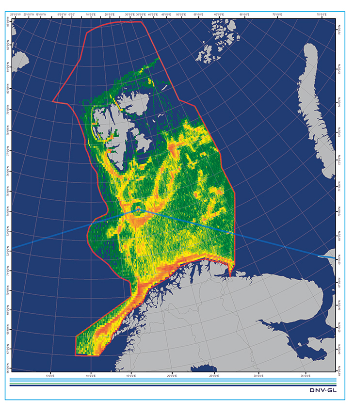
Figure 3.1 Traffic density map for fishing vessels in the management plan area in 2014. The blue line marks the boundary of Arctic waters as defined by the Polar Code.
Source DNV GL. The figure is based on AIS data from the Norwegian Coastal Administration.
Textbox 3.2 Capelin as a key species in the Barents Sea
The capelin stock shows wide natural variations. The species is an important predator on zooplankton, and grazing pressure from capelin is so great that the quantity of zooplankton tends to decrease as the capelin stock increases, and vice versa. Capelin feed to a large extent in the marginal ice zone and migrate to Norway’s northern coast to spawn. They thus transport energy from biological production in the marginal ice zone to more southerly parts of the Barents Sea. Juvenile herring feed on capelin larvae, and this predation pressure can cause the capelin stock to collapse when the abundance of juvenile herring in the Barents Sea is high.
Most of Norway’s commercial fish stocks are shared with other countries. In accordance with international obligations, we therefore cooperate on stock sharing, determining annual total allowable catches (TACs) and other management measures. For stocks in the northern part of the management plan area, the main cooperation forums are the Joint Norwegian-Russian Fisheries Commission and the North East Atlantic Fisheries Commission (NEAFC). In addition, Norway has an extensive national system of regulatory control measures, including monitoring and control carried out by the Coast Guard.
Norway and Russia practise joint management of the most important fish stocks in the Barents Sea, including Northeast Arctic cod, Northeast Arctic haddock, capelin, Greenland halibut and beaked redfish. The joint fisheries commission and its bodies set TACs and share them between Norway, Russia and third countries. The parties also agree on reciprocal fishing rights in each other’s zones, exchange quotas for both joint stocks and national stocks, and harmonise regulatory measures. They have drawn up management plans for cod, haddock and capelin including target stock levels and trigger points as a basis for setting TACs. The TACs jointly determined by Norway and Russia are based on management strategies agreed by Norway and Russia and on recommendations on catch levels from the International Council for the Exploration of the Sea (ICES), which includes both Norwegian and Russian scientists. Efforts to eliminate overfishing, together with joint management strategies and Norwegian-Russian cooperation on resource control, have been very important in improving the state of the Barents Sea cod stock, which is now highly satisfactory.
The TAC for Northeast Arctic cod in 2015 has been set at 894 000 tonnes. Norway and Russia have been allocated equal shares of this, and a quota is set aside for third countries (the EU, Iceland, Greenland and the Faeroe Islands). The TACs for Northeast Arctic haddock and capelin have been set at 178 500 tonnes and 120 000 tonnes respectively.
In recent years the distribution of some of the most important fish species in the Barents Sea has expanded considerably, and they are now found as far north as the waters around Svalbard and further northeast in the Barents Sea in summer and autumn (see Figure 3.2). This change is particularly marked for Northeast Arctic cod and haddock and for capelin. In addition, the distribution of mackerel has shifted northwards, and mackerel are now to be found far north in the Barents Sea in summer.
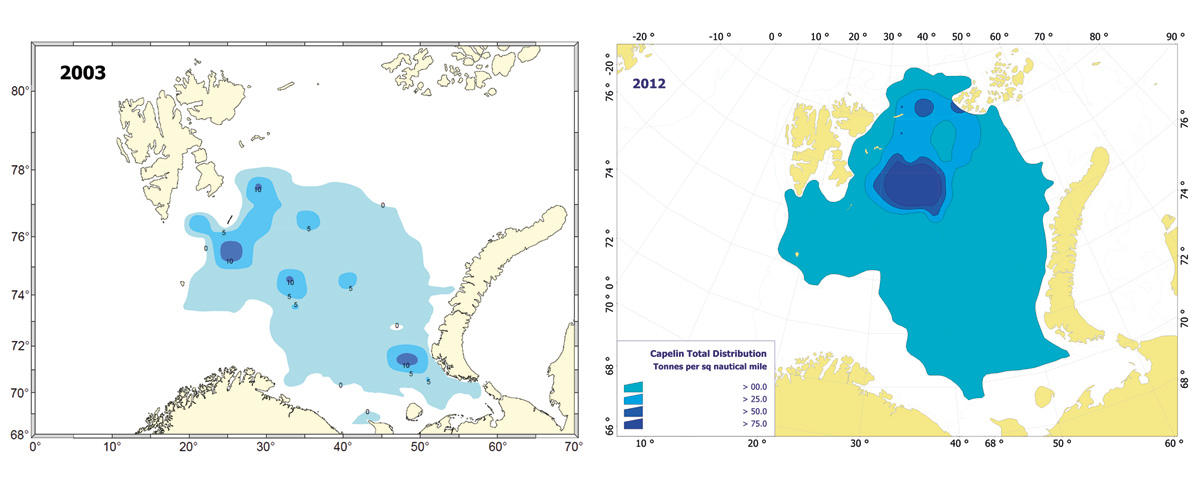
Figure 3.2 Changes in the distribution of capelin on feeding grounds in summer; the range has expanded and shifted from the central to the northeastern part of the Barents Sea. Distribution of capelin in 2003 (left) and 2012 (right).
Source Institute of Marine Research.
As a result of climate change, even larger sea areas are expected to be ice-free in summer and autumn, which may result in changes in harvesting patterns in the fisheries.
The greatest biological pressure on the marine environment is the deliberate harvesting of commercial fish stocks. Harvesting is an intentional and managed pressure on the ecosystem, but can have environmental impacts if harvesting levels are not sustainable.
The Coast Guard and the fisheries control system
The Coast Guard is responsible for resource control, in other words effective monitoring, maintaining an appropriate presence and carrying out regular inspections in all areas where there are commercial fishing activities. Priority is given to selected areas where the level of activity is highest and where breaches of the legislation are most likely. The Coast Guard therefore gives priority to preventing overfishing in the Barents Sea, discards of fish and unregistered landings, and to problems associated with bycatches. Through its operations, the Coast Guard exercises authority in the Economic Zone of Norway, the fisheries zone around Jan Mayen and the fisheries protection zone around Svalbard. Its operations are supported by satellite, aircraft and helicopter monitoring.
Information system for the fishing fleet
The fishing fleet has for a long time felt the need for an integrated, practical information system for distributing and reporting key information to vessels’ own instrument systems. A joint project between the Norwegian Seafood Research Fund (which represents the seafood industry) and BarentsWatch (cooperation between government agencies and research institutes) has now resulted in a first version of an information system called FiskInfo. This has been available to the fishing fleet since February 2015. This version makes it possible for vessels to have updated information on their own chart plotters at all times, including data on deployed fishing gear, subsea installations, and planned and ongoing seismic surveys. BarentsWatch is to develop FiskInfo further so that it can provide services that are also useful for other vessel types and for other types of operations at sea and along the coast. Relevant user groups from maritime industries and the oil and gas industry will therefore be involved in the project in the course of 2015.
3.3 Maritime transport
The current traffic situation
Information on shipping in the waters around Svalbard has been considerably improved with data from the Norwegian AIS satellites, which pick up and transmit data on vessel position and movements. However, the historical data on trends in traffic patterns and volumes over time are still not good enough.
In 2014, just over 550 vessels (unique ships, both Norwegian and foreign) were registered in the part of the management plan area that will be within Arctic waters as defined by the Polar Code. About half of these were fishing vessels. The second largest vessel category was passenger/cruise ships (45 vessels). Chemical and oil tankers made up only a small proportion of the total, 17 vessels in all.
Data for total distance sailed show a similar pattern. Fishing vessels are the dominant category at present, accounting for about 69 % of the total distance sailed.
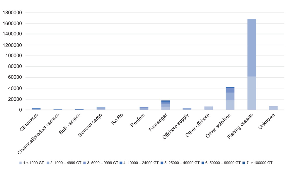
Figure 3.3 Distance sailed (nm) in 2014 in the part of the management plan area within Arctic waters as defined by the Polar Code.
Source DNV GL. The figure is based on AIS data from the Norwegian Coastal Administration.
Expected trends
Few projections have been made for the Arctic, and those that are available are very uncertain. However, most of them indicate that a gradual increase in the volume of shipping in the Arctic is to be expected. The extend and speed of the increase are more uncertain, and are closely related to other uncertain factors, trends in and the profitability of industries that drive developments in shipping. The largest increase in the region is expected for traffic associated with oil and gas activities and for ships in transit, a result of reductions in multi-year ice and sea ice extent.
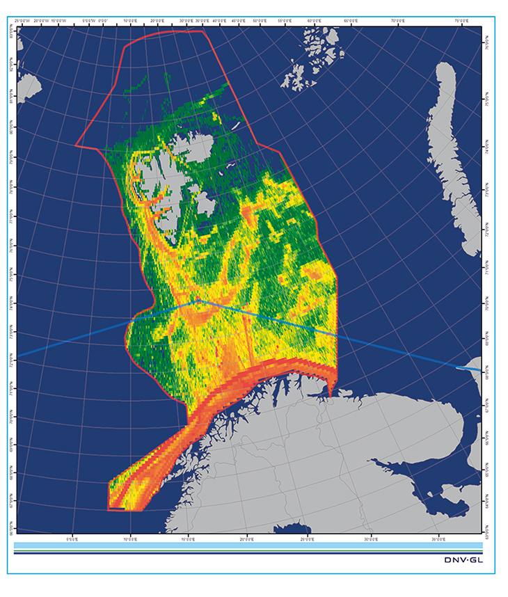
Figure 3.4 Traffic density map for all types of vessels in the management plan area in 2014.
Source DNV GL. The figure is based on AIS data from the Norwegian Coastal Administration.
To prevent accidents and harmful releases of pollutants, the shipping industry needs to maintain high maritime safety and environmental standards.
Environmental pressures from maritime transport and work in progress by IMO
Shipping can have adverse impacts on the environment through releases both to the sea and to air. Releases to the marine environment include various types of operational discharges. In addition, accidental spills of oil and chemicals may occur. A spill of heavy oil in the Arctic could have very serious environmental impacts.
Operational discharges to the sea from shipping are very strictly regulated under international agreements.
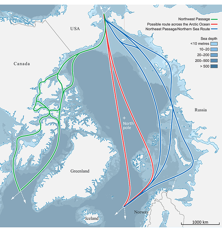
Figure 3.5 Main routes expected to be used by shipping across the Arctic Ocean. The most direct route (red lines) should be considered as a corridor with many options.
Source Norwegian Polar Institute.
In addition, shipping is responsible for air pollution, for example releases of nitrogen and sulphur oxides. Emissions of soot, or black carbon, are also a problem in the Arctic because soot is a short-lived climate pollutant that is having a considerable impact in parts of the Arctic, and because soot emissions are not regulated. The International Maritime Organization (IMO) is addressing the problems of soot emissions. The spread of alien species attached to ships’ hulls or in ballast water can disturb the ecological balance in the Arctic. When the IMO Ballast Water Convention enters into force, it will go a long way towards eliminating the spread of alien species in this way. More knowledge is needed to understand the possible impacts of underwater noise from shipping. IMO has adopted voluntary guidelines for the reduction of underwater noise from shipping.
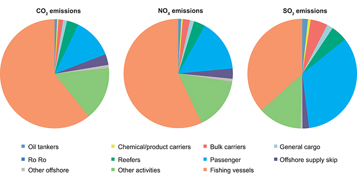
Figure 3.6 Releases of CO2, NOx and SOx from shipping in the part of the management plan area within Arctic waters as defined by the Polar Code.
Source DNV GL. The figure is based on AIS data from the Norwegian Coastal Administration.
Environmental risk in the northern part of the Barents Sea
The environmental risk (the probability of acute pollution multiplied by the potential consequences of spills) associated with oil or chemical spills from ships in the Barents Sea varies from one geographical area to another and between seasons. The potential consequences will be most serious if a spill could affect areas where there are high densities of vulnerable species or areas of vulnerable habitat, such as the marginal ice zone and coastal waters. In the Barents Sea, spills in the open sea may also have serious impacts, since there are high densities of vulnerable seabirds in different parts of the sea area at certain times.
The environmental risk associated with shipping is currently highest near the west coast of Svalbard and around Bjørnøya. The probability of incidents involving spills from shipping is also highest in these areas. However, the probability of spills is lower in the waters around Svalbard and Bjørnøya than along the mainland coast of Norway. Because the use of heavy bunker oil is prohibited around much of Svalbard, lighter fuel types are more widely used than along the mainland coast. This has implications for the organisation of the preparedness and response system for acute pollution. On the other hand, there are various areas where the environment is very vulnerable to oil pollution, and the environmental consequences of a spill could be severe. In 2012, as part of efforts to improve preparedness and response to acute pollution, a new mapping tool was established, called PRIMOS (priority areas of environment in Svalbard). Using the tool, the geographical positions of vulnerable species and habitats in and around Svalbard can be mapped and priorities defined, making it possible to concentrate clean-up operations where they are most needed in the event of a spill.
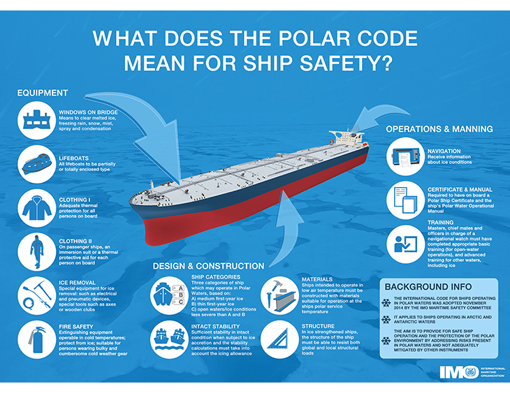
Figure 3.7 Safety requirements for ships under the IMO Polar Code.
Source International Maritime Organization.
Prohibition against carrying heavy bunker oil in the protected areas around Svalbard
The prohibition against carrying heavy bunker oil in the protected areas around Svalbard was introduced in 2007, and its scope was expanded from 1 January 2015. It is now prohibited to carry heavy bunker oil when sailing to Ny-Ålesund and Magdalenefjorden, two routes that were formerly excepted from the prohibition. Ships are not permitted to use or carry heavy bunker oil when sailing into Nordaust- and Søraust-Svalbard nature reserves on the east coast of Svalbard or the three large national parks Sør-Spitsbergen, Forlandet and Nordvest-Spitsbergen in the western part of the archipelago. Instead, they must use light marine diesel, which causes less serious pollution in the event of a spill.
The IMO Polar Code
Like shipping in other parts of the world, shipping in polar waters is subject to the rules of international conventions adopted by IMO. Until now, this regulatory framework has not been adapted to the particular conditions found in polar waters. The development of global binding rules for ships operating in Arctic and Antarctic waters was put on the IMO agenda in 2009 after a proposal by Denmark, Norway and the US. IMO adopted the Polar Code in 2014. Norway has played a key role in the development of the Polar Code and coordinated the work under IMO. The Polar Code lays down globally binding rules for ships operating in polar waters, i.e. Arctic and Antarctic waters. Its rules apply in addition to those of already existing conventions and codes on maritime safety and pollution from shipping (SOLAS, MARPOL, the STCW Convention, etc).
The Polar Code consists of two parts, one on safety and one on environment-related matters. It sets specific requirements for ships operating in polar waters, for example on ship design, equipment, operations, environmental protection, navigation and crew qualifications. The Polar Code enters into force on 1 January 2017.
The most important environment-related provisions deal with pollution by oil, chemicals, sewage and garbage released from ships. The Polar Code is considered to be one of the most important developments for improving maritime safety in polar waters. The Norwegian Government will take steps to ensure its effective implementation.
Particularly Sensitive Sea Areas (PSSAs)
Member states can apply to IMO to have certain areas designated as Particular Sensitive Sea Areas (PSSAs). The approval process involves assessing the sensitivity of the area against its vulnerability to environmental pressures and the risk of damage by shipping activities. If an area is designated as a PSSA, control measures must be identified to prevent damage. These are dealt with by IMO on a case-by-case basis since they may involve new requirements that necessitate amendments to conventions or the publication of recommendations.
So far, 14 PSSAs have been designated in different parts of the world (see Figure 3.8).
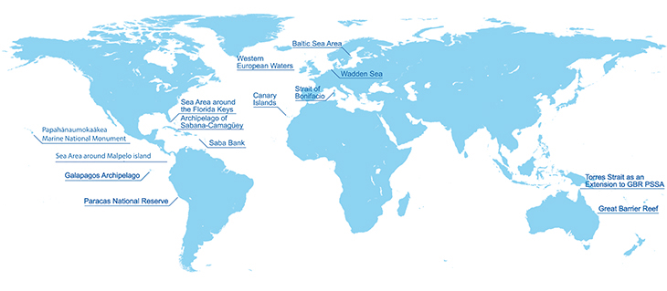
Figure 3.8 Map of existing PSSAs.
Source International Maritime Organization.
In 2013, the Protection of the Arctic Marine Environment Working Group (PAME) under the Arctic Council published a report reviewing and making recommendations on specially designated Arctic marine areas in the Arctic high seas (the AMSA II(D) report. The review was intended to provide a basis for assessing possible joint proposals for the risks posed by international shipping activities.
Maritime safety (coastal state measures)
Maritime safety measures are an essential basis for safe, effective maritime transport. In recent years, a number of preventive measures have been introduced, and together, they have considerably reduced the risks associated with shipping in the Arctic.
Systems for monitoring shipping in Norwegian waters have been considerably strengthened. The Vardø VTS Centre monitors shipping throughout Norway’s exclusive economic zone and in the fisheries zone around Svalbard, focusing particularly on tankers and other high-risk traffic. It also issues navigational warnings for shipping in Arctic waters. The Norwegian AIS satellites make it possible to pick up position data even from vessels that are far out at sea, and put the Norwegian authorities in a better position to take action if incidents occur at sea. Traffic separation schemes and recommended routes have been established from Vardø to Røst and off the coast of Western and Southern Norway. These divert high-risk traffic away from the coast, and analyses show that they considerable reduce the probability of and consequences of accidents.
In summer 2013, a mandatory ship reporting system, Barents SRS, was established. Under this system, which has been approved by IMO, higher-risk categories of ships are required to submit reports of their positions when sailing in the Barents SRS area. The system gives both Norwegian and Russian authorities a better picture of maritime traffic in the Barents Sea.
In 2012, the Norwegian state pilotage service was extended to the waters around Svalbard. The pilots use their local knowledge of the waters and navigation expertise to ensure safe navigation in coastal waters.
The Norwegian Coast Guard has important functions related to search and rescue, maritime safety, oil spill preparedness and response, tugboat capacity and other civilian tasks. The Coast Guard plays a part in national emergency preparedness through its participation in coastal emergency response and on-scene command. As the NH 90 maritime helicopters are phased in, monitoring and search and rescue capacity in coastal and marine areas will improve.
Nautical charting and accurate charts are of crucial importance for maritime safety. There are many areas around Svalbard that have not been charted and where no satisfactory depth measurements are available. Surveys have been made more efficient in recent years with new equipment and new survey vessels. On the west coast of Svalbard, priority is being given to those of the remaining non-surveyed areas that are most important for tourist traffic. To the north and east of Svalbard, the priority is to survey areas that are of special importance for safe navigation around the archipelago. Progress in surveying the waters around Svalbard depends on suitable weather conditions during the short survey season, and on being able to use the available resources effectively. Plans and priorities for surveying around Svalbard are drawn up in consultation with the Coast Guard, research institutions and the Governor of Svalbard.
The monitoring and information system BarentsWatch has been developed through the High North cooperation and will also help to improve maritime safety.
In spring 2015, the Government will publish a new maritime strategy, in which one of the topics covered will be the High North. The Government also plans to submit a white paper providing an overall review of maritime safety and the preparedness and response system for acute pollution. The High North will be an important element of this white paper as well.
3.4 Petroleum activities
Petroleum activities in the Barents Sea South
The Storting opened the Barents Sea for oil and gas activities in 1979. At that time, 20 blocks in the Tromsøflaket area were opened. Exploration drilling started, and the Askeladd field, which is part of the Snøhvit development, was discovered in 1981. Later in the 1980s, further areas of the Barents Sea South were opened, and nearly all of the remaining area was opened in 1989. In all, 137 wells have been drilled in the Barents Sea.
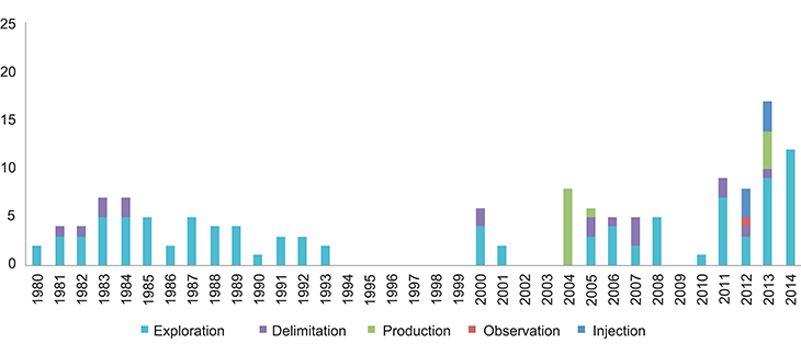
Figure 3.9 Wells drilled in the Barents Sea 1981–2015.
Source Norwegian Petroleum Directorate.
Several oil and gas discoveries of varying sizes have been made. The Snøhvit field (gas and condensate) has been developed and is producing, and Goliat is under development and should start producing oil in the course of 2015. The planning process for development of the Johan Castberg field is well under way.
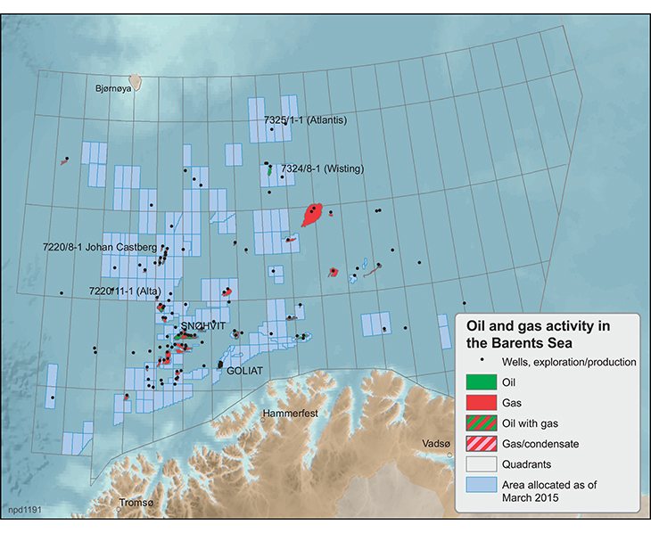
Figure 3.10 Oil and gas activities in the Barents Sea.
Source Norwegian Petroleum Directorate.
A few exploration wells were drilled in the northern part of the Barents Sea towards the end of the 1980s. In 2013 and 2014 new exploration wells (Wisting (three wells), Apollo, Mercury, Saturn, Pingvin and Isfjell) were drilled.
Opening of the southeastern part of the Barents Sea
In 2011, the Government decided, with the approval of the Storting, that once the maritime delimitation treaty between Norway and Russia for the Barents Sea and Arctic Ocean had entered into force, it would initiate an impact assessment in accordance with the Petroleum Act for the previously disputed area west of the delimitation line in the Barents Sea South, with a view to granting production licences and collecting data from the area, see the white papers An industry for the future – Norway’s petroleum activities (Meld. St. 28 (2010–2011)) and the first update of the Barents Sea–Lofoten management plan (Meld. St. 10 (2010–2011)).
The impact assessment for the Barents Sea southeast was carried out in 2012/2013. It was followed up by the publication of two white papers (Meld. St. 36 and 41 (2012–2013)); these were debated by the Storting, which decided to open the southeastern part of the Barents Sea for petroleum activities.
The white papers on the Barents Sea southeast state that no petroleum activities will be initiated in the areas along the edge of the marginal ice zone and the polar front at present, but also point out that this does not preclude oil and gas activities throughout the southeastern part of the Barents Sea.
Petroleum activities in the marginal ice zone and the 23rd licensing round
Petroleum activities in Norway are subject to strict requirements as regards the health, safety and working environment framework and environmental concerns. It is also considered important to facilitate coexistence with other industries. The same also applies to the Barents Sea and in the 23rd numbered licensing round.
In accordance with the framework the Storting has approved for the 23rd licensing round, there are restrictions on when exploration drilling is permitted along the outer edge of the marginal ice zone (wherever this is located at the time of operation). The Government has made these restrictions applicable to the whole of the Barents Sea for the 23rd licensing round. The framework that applies to new production licences for the Barents Sea safeguards species and ecosystems in the marginal ice zone.
In addition, recent sea ice data show that the marginal ice zone, as delimited using ice data for the period 1985–2014, is north of the areas that have now been opened for petroleum activities. The definition of the marginal ice zone is discussed in depth in Chapter 2 of the present white paper.
This means that there will be no petroleum activities in the marginal ice zone in the current parliamentary period.
Environmental risk associated with oil spills
Oil and gas drilling and production entail a certain risk of events that may result in acute pollution. The 2011 white paper on the Barents Sea–Lofoten management plan concludes that generally speaking, the probability of major spills from petroleum operations is low, and will remain low up to 2020 according to conservative estimates based on realistic predictions of the level of activity in the area. Releases of gas have only limited adverse impacts on the environment. To avoid any increase in risk levels, measures can be taken to reduce the probability of acute pollution and, in the event of an incident, to limit the impacts. The possible environmental impacts of spills differ considerably from one geographical area of the Barents Sea to another and between seasons, just as they do in other areas of the Norwegian continental shelf. The consequences will depend mainly on the size of the spill, the type of hydrocarbons released, and when and where the spill occurs in relation to valuable and vulnerable areas and living marine resources.
The potential consequences will be greatest if a spill could affect areas where there are high concentrations of valuable species and habitats, such as the marginal ice zone and coastal waters. In the Barents Sea, spills in the open sea may also have serious impacts, since there are high densities of vulnerable seabirds in different parts of the sea area at certain times.
Analyses carried out as part of the planning process for exploration drilling in the Barents Sea show that environmental risk is strongly associated with the when and where large numbers of seabirds congregate in the open sea. For activities nearer the coast, the highest environmental risk is associated with the large seabird colonies on land (including Bjørnøya). At the most northerly sites where exploration drilling has been carried out so far (the Wisting wells, Apollo and Mercury), the analyses show a certain probability of consequences in the marginal ice zone in the event of a major oil spill during drilling at certain times of year.
The established methodology for assessing environmental risk needs to be adapted to deal with special challenges such as how to calculate oil drift in ice.
Safety considerations for petroleum activities in icy waters
In winter, ice, prolonged darkness, low temperatures and polar lows are all typical of the northernmost areas on the Norwegian continental shelf. In summer, fog can be a problem. People working in the Barents Sea have to contend with changeable weather at all times of year. However, wind and wave conditions become gradually better further north and east in the area.
Oil and gas installations that are to be used in the Barents Sea must be adapted to meet these weather conditions. Installations and equipment must be protected against the low temperatures so that it is safe for people to work on board, a process known as winterisation. This ensures that equipment and workplaces can operate as normal even in the harsh winter weather. The most important step is to enclose parts of the installation, but this means that the risk of gas accumulation and explosions must be considered. Examples of winterised equipment include insulation of pipes, work clothes that are specially designed for low temperatures and better lighting for the winter darkness.
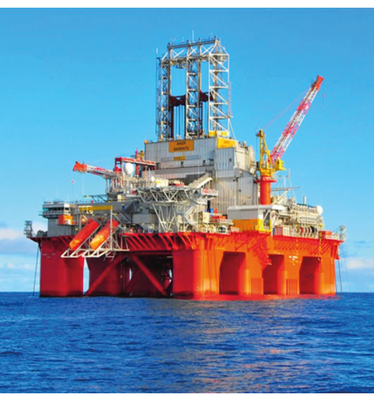
Figure 3.11 Winterised drilling rig. Transocean Barents.
Source Transocean.
In the northernmost areas that have been opened for petroleum activities, uncertainty about the presence of sea ice poses special challenges. The distribution of the sea ice is not static – it varies seasonally and from year to year. In addition, ice is not just ice; there are many different types. Because of their size, icebergs are a threat and have the potential to cause serious damage. Smaller pieces of ice may be remains of icebergs or smaller ice floes that have separated from the pack ice and are drifting southwards. Icebergs are rather easier to detect than smaller pieces of ice, which can be difficult to distinguish from the water surface even though they are still large enough to cause damage to installations and equipment near the surface. Icebergs, smaller pieces of ice and ice floes all constitute a real risk to installations and to well control. In areas where icebergs and sea ice may be encountered, good strategies and tools for dealing with risk must therefore be in place, for example:
ensuring that reliable ice projections and forecasts are available so that safe time windows for operations can be identified;
using robust methods for monitoring ice, so that steps to make operations safe or to halt them can be taken as soon as possible;
towing away icebergs, smaller piece of ice or ice floes that are on a collision course with an installation;
designing installations so that they can withstand collisions;
disconnecting and moving installations until an iceberg has passed;
using subsea installations for production, with wellheads, Christmas trees and pipelines buried in the seabed.
3.5 Preparedness and response system for acute pollution and special challenges relating to operations in icy waters
Oil spill preparedness and response in Arctic conditions
We now have a good basis for assessing the special challenges relating to oil spill preparedness and response system under Arctic conditions, existing methods for dealing with oil in ice, and the need for further development of oil spill response technology. The Norwegian Coastal Administration has drawn up an environmental risk and emergency preparedness analysis for Svalbard, Jan Mayen and Bjørnøya, which uses environmental risk as a starting point for evaluating the need for governmental preparedness and response capability to deal with acute pollution and major spills in icy waters.
The northernmost sea areas have little infrastructure and limited telecommunications coverage and capacity: the availability of oil spill response equipment and personnel is also limited, there is a lack of sites where recovered oil and waste can be deposited, and distances are long, meaning that response times are also long if there is an incident.
Natural conditions will also affect oil spill recovery operations – for instance the very limited daylight for part of the year, low temperatures and the risk of icing on equipment, and the often rapid shifts in weather conditions. The presence of ice makes it considerably more difficult to deal effectively with acute pollution. These conditions mean that the methods and strategies, material and vessels for dealing with oil spills need to meet other requirements than those that apply in the waters off mainland Norway. Finding efficient logistics solutions will be a major challenge for all types of operations in Arctic waters. Personnel and material will need to be transported to and from the area affected during an oil spill operation, and recovered oil will have to be transported out of the area unless it is burned off in situ. Operational platforms including ships, aircraft and drones must be robust and meet adequate safety standards. It is essential to comply with health, safety and working environment requirements for response personnel during all types of activities.
It would be very demanding to carry out a large-scale shoreline-cleaning operation in Svalbard because of the long distances involved and the lack of resources and infrastructure on land. Dealing with waste would be particularly difficult, and it will be necessary to focus on techniques for reducing waste quantities.
Existing methods for dealing with oil spills in ice
Practical experience of oil spill response operations, including the recovery of oil released when MS Godafoss grounded off the Hvaler archipelago in the outer Oslofjord in winter 2011, indicates that there are currently no adequate and effective methods for dealing with oil in waters where ice is present. There is considerable uncertainty about the efficiency of the equipment that is available, possible operational problems and the environmental impacts of response techniques. Whenever oil or chemical spill operations are organised, possible response techniques must always be evaluated to determine the methods that will result in least environmental damage. The following methods may be appropriate for operations in Arctic waters:
Mechanical recovery using conventional booms and skimmers
Mechanical recovery involves collecting and concentrating oil using booms and then removing it from the surface using various types of skimmers. Mechanical recovery as close as possible to the source of pollution is the primary strategy for the governmental preparedness and response system for acute pollution. Practical experience of response operations shows that it is possible to use conventional mechanical equipment even if ice is present, but a drop in efficiency is to be expected.
Chemical dispersion
Chemical dispersion involves applying a dispersant, a chemical solution, to an oil slick to break up the oil into small droplets. The oil droplets spread and are diluted in the water column, and are gradually broken down. The Government (the Norwegian Coastal Administration) does not currently maintain any chemical dispersion capacity. The petroleum industry (the Norwegian Clean Seas Association for Operating Companies, NOFO) has dispersants and application technology available to deal with spills on the Norwegian continental shelf, but this has not been specifically adapted for use where ice is present.
Simulations and development programmes indicate that chemical dispersion can be an effective way of dealing with spills of diesel in cold conditions and partial ice cover. Further research and development is needed concerning the efficiency of dispersion and its possible environmental impacts.
In-situ burning
For in-situ burning, an ignition device is used to start the burn. It may be necessary to concentrate the oil using fire-resistant booms to ensure that the slick is thick enough to burn. In-situ burning has not so far been used during clean-up operations in Norway.
The long distances, limited oil spill response resources (equipment and personnel), the logistical challenges involved in handling recovered oil and with oil in ice are all arguments for dealing with an oil spill on-site as far as possible. In-situ burning can deal with relatively large quantities of oil quickly and only generates moderate amounts of waste. This may therefore be an appropriate method. In recent years, R&D projects have shown that in-situ burning can be effective in ice. However, it also results in emissions of soot to the Arctic environment. More knowledge and further development of methods is needed, for example as regards the environmental impacts of in-situ burning.
Shoreline clean-up
Shoreline clean-up is generally the most time-consuming and resource-intensive part of an oil spill response operation, and often requires protracted efforts and a large workforce. If shoreline clean-up is required in Arctic areas, the limited availability of personnel and other resources over time and factors such as the lack of daylight in the winter months will make this an even more challenging process than in other parts of Norway. Many areas where oil might make landfall are inaccessible and it can be difficult to go ashore. Special safety assessments would therefore be necessary. Dealing with recovered oil is also particularly difficult in such areas.
Monitoring and remote sensing
Monitoring and remote sensing are used to obtain the best possible information on where an oil spill is at any time. This is essential for effective response operations. It is particularly important under Arctic conditions, where operations will often have to be carried out in darkness, foggy conditions and in icy waters. Data from remote sensors makes it possible to deploy response equipment and personnel to best effect. Using remote sensing normally makes it possible to treat or recover more oil. The Norwegian Coastal Administration has new oil recovery vessels equipped with infra-red cameras and oil spill detection radar. These provide good capacity for remote sensing, but have clear limitations in ice-covered waters. The Coastal Administration’s surveillance aircraft is also equipped with radar and infra-red systems, and has sufficient range to fly directly from the mainland to an oil spill in Arctic waters. The aircraft has proved to be very valuable during response operations. Considerable advances are expected in surveillance and remote sensing systems adapted for Arctic conditions. All NOFO’s vessels on permanent stand-by are equipped with oil spill detection radar and infra-red sensors.
Need for further development of oil spill response technology
The volume of shipping in areas north of the coast of Finnmark and northwards to Svalbard is expected to increase in the next few years, and petroleum activities are expanding northwards. New knowledge, products and technology will therefore be needed to find solutions to the problems involved in oil spill response operations in a cold climate and icy waters. Solutions are needed that will provide better capacity and be more effective, and that will expand the window of opportunity for operations, for example in terms of light, visibility and temperature. It will also be important to develop better methods of separating oil and water, transport methods and logistical solutions as support for response operations. The logistical challenges also mean that there is an even more pressing need for better technology and knowledge about in-situ treatment of oil, for example burning and chemical dispersion in ice.
The Norwegian Coastal Administration is cooperating with NOFO on the Oil Spill Response 2015 programme. Projects focusing on oil spill response in the Arctic, including topics such as collection technology, dispersion, remote sensing and in-situ burning, are of particular interest in this technology development programme.
Textbox 3.3 Preparedness and response to acute pollution
Governmental preparedness and response
The Norwegian Coastal Administration has 16 oil spill response depots along the Norwegian coast. They hold booms, skimmers, shoreline clean-up equipment and emergency off-loading units. Each depot has a staff of 10 and a supervisor. The locations of the depots and the types of equipment stored there have been decided based on the Administration’s emergency preparedness analysis, which includes calculations of the probability and consequences of acute pollution along different stretches of coastline. Most of the equipment is designed for use in coastal waters.
The Coast Guard has 11 vessels and the Coastal Administration owns six, and all of these carry specialised oil spill response equipment. The crews of the vessels have received training in the use of the equipment in oil response operations. The Coastal Administration also has contracts for the use of 35 smaller vessels. These are privately owned, but will be made available to the Coastal Administration in the event of an oil spill response operation. These vessels do not normally carry oil spill response equipment, but will use equipment from the depots if deployed to an operation. The Polarsyssel, the Governor of Svalbard’s vessel, is an important resource for the preparedness and response system for acute pollution in the waters around the archipelago. The ship carries oil spill response equipment during the part of the year when it is in use around Svalbard.
The emergency tugboat service has four vessels stationed along the Norwegian coast. These are also privately-owned, and are contracted to the Coastal Administration. The Vardø VTS Centre can use the tugboats the traffic situation makes it necessary. The primary task of the tugboats is to prevent vessels from drifting ashore.
In addition to their own preparedness and response resources, both the operators and the Coastal Administration have access to additional resources through agreements with other countries and organisations.
Private preparedness and response
Through their own organisation NOFO, the operating companies have access to 31 oil recovery vessels that meet NOFO standards and 34 vessels suitable for towing in the open sea. In addition, there are 25 ocean-going mechanical recovery systems and 10 ocean-going oil dispersion systems. One vessel carrying equipment for both mechanical recovery and dispersion is permanently deployed to the Goliat field. In addition, three recovery and dispersion systems are available at the Hammerfest base. If further resources are required for operations in the Barents Sea, they must be obtained from bases further south on the continental shelf and along the Norwegian coast (Sandnessjøen, Kristiansund, Mongstad, Stavanger). The current NOFO standard for oil recovery vessels is from 2009 and does not include specific requirements for adaptation or strengthening for operations in ice. NOFO also has 63 oil recovery vessels for coastal operations, 30 in Finnmark and 30 from the Lofoten Islands (Vestfjorden) south to Stad at 62°N. In addition, NOFO has the use of three support vessels, four speed barges, and one large and two small work barges. Recovery equipment includes 25 coast and fjord systems and various boom types, including absorbent booms.
NOFO has also established an emergency task force for shoreline cleanup, consisting of 40 people who can quickly be deployed to critical areas with high-speed vessels and with the necessary equipment to limit damage along the shoreline.
International cooperation on emergency preparedness and response in the Arctic and the Barents Sea
As mentioned in Chapter 1, the Arctic Council has a permanent Emergency Prevention, Preparedness and Response Working Group (EPPR). Its goal is to contribute to the protection of the Arctic environment from the threat or impacts of accidental releases of pollutants or radionuclides and to deal with the consequences of natural disasters. The members exchange information on best practices and carry out projects on topics including the development of guidelines and risk assessment methodologies, response exercises and training. The EPPR is also responsible for maintaining the operational guidelines for the cooperation agreement discussed in the next paragraph. Current projects include developing a guide to oil spill response in snow and ice conditions and a searchable database of Arctic oil spill response assets.
The Arctic states (Norway, Canada, Denmark, Finland, Iceland, Russia, Sweden and the US) signed the Agreement on Cooperation on Marine Oil Pollution Preparedness and Response in the Arctic at the Arctic Council ministerial meeting on 15 May 2013. The agreement establishes binding cooperation on preparedness and response at operational level between the member states of the Arctic Council. It includes provisions on notification of oil pollution incidents and routines for receiving and providing assistance. Operational guidelines have been drawn up for the agreement. The agreement strengthens the overall preparedness and response system and the joint capacity of the Arctic states to respond to major oil spills in the region.
At the ministerial meeting in Kiruna in 2013, the Arctic Council decided to establish a Task Force on Arctic Marine Oil Pollution to draw up a plan for the Arctic Council’s contribution to preventing marine oil pollution in the Arctic. The Task Force has drawn up a framework plan for cooperation on prevention of oil pollution from petroleum and maritime activities in the marine areas of the Arctic, which is to be discussed at the ministerial meeting in Iqualuit in April 2015.
In 1994, Norway and Russia entered into a bilateral agreement on combating oil spills in the Barents Sea. The agreement has been implemented in the form of a joint contingency plan and annual joint exercises, the most recent of which took place in the outer Varangerfjord, in the border area between Norway and Russia, in June 2014.