2 Environmental status and particularly valuable and vulnerable areas
As mentioned earlier, the present update of the management plan focuses on updating the boundaries of the ice margin and providing an up-to-date description of the northern part of the management plan area, particularly in view of the rapid changes that are taking place as the sea temperature rises and the extent of the sea ice shrinks. Arctic temperatures have risen rapidly and there has been a marked reduction in sea ice cover in recent years. These trends are apparent throughout the region, and according to the Intergovernmental Panel on Climate Change (IPCC), it is very likely that they are a result of anthropogenic climate change. Some of the most rapid changes in the Arctic are being observed in the Barents Sea area. This chapter describes the observed changes and their implications for the Barents Sea ecosystem, and to some extent also the expected future trends as regards climate and sea ice.
Two advisory groups with participants from relevant public authorities and research institutions have been established to develop the scientific basis for the marine management plans. These are the Forum for Integrated Marine Management, chaired by the Norwegian Environment Agency, and the Advisory Group on Monitoring, chaired by the Institute of Marine Research. In 2014, the Advisory Group presented an assessment of the state of the Barents Sea–Lofoten ecosystem, focusing on changes. The descriptions in this chapter are largely based on their report. The main elements of the scientific basis for this update of the management plan are the updated scientific information in the Advisory Group’s assessment report, together with the updated calculations from the Norwegian Polar Institute of the delimitation of the marginal ice zone as a particularly valuable and vulnerable area, and reports on oil spill preparedness and response and shipping in Arctic waters. The Forum for Integrated Marine Management will coordinate the preparation of the scientific basis for the 2020 revision of the management plan.
2.1 Environmental status
The inflow of warm Atlantic water to the Barents Sea ensures that the Norwegian coast and large parts of the Barents Sea are ice-free all year round. Where the Atlantic water meets colder Arctic water, an oceanographic front is formed, called the polar front. Other frontal zones are found along the edge of the continental shelf and in the marginal ice zone. During the winter, the marginal ice zone more or less overlaps the polar front. Frontal zones are highly productive, supporting rich blooms of planktonic algae that are grazed by zooplankton and in turn provide food supplies for fish, seabirds and marine mammals. The Barents Sea is a relatively shallow sea (average depth 230 m) with large very shallow bank areas, so that the whole area is very productive. Biological production in the Barents Sea forms the basis for the large fish stocks that support Norway’s fishing industry. Herring, capelin, cod and haddock use the area throughout their lives or for part of their life cycle, and all of these species migrate towards the Norwegian coast to spawn. The most concentrated spawning grounds are near the Lofoten and Vesterålen Islands. From here, eggs and larvae drift northwards along the coast and into the Barents Sea, where the juvenile fish grow and mature. Because of its high productivity, the Barents Sea supports some of the largest concentrations of seabirds in the world. In addition, the northern part of the Barents Sea is an important habitat for a number of marine mammal and seabird species that are not found in areas without ice cover; several of these are of national and international importance.
One characteristic of the Barents Sea is that physical factors such as temperature and ice conditions vary widely between seasons and from year to year, and this has significant effects on the ecosystem. However, there are also some clear trends in environmental conditions, especially as regards temperature and sea ice. Throughout the Arctic, temperatures have been rising twice to three times as fast as the global average, and the extent of the sea ice has declined markedly in recent decades. Climate models indicate that the warming trend will continue in the Norwegian Arctic. In the longer term, trends in temperature and ice conditions will depend on whether the world is successful in reducing global greenhouse gas emissions. The trend towards higher temperatures and less ice cover in the Arctic also involves positive feedback mechanisms; less snow and ice cover means less incoming sunlight is reflected, and more open water means more solar irradiation is absorbed. Further reductions in sea ice extent in the Barents Sea may have serious consequences for ice-dependent species, which will lose much of their habitat and be displaced further north and east. In addition, Higher sea temperatures are expected to result in a northward shift of more southerly species, and this will also have consequences for the Barents Sea ecosystem.
2.1.1 Rising temperatures and shrinking ice cover
In recent decades, both air and sea temperatures in the Barents Sea area have been rising sharply. One reason for this has been an increase in heat transfer to the Barents Sea with the inflow of relatively warm Atlantic water. Measurements in the southern Barents Sea, where the inflow of Atlantic water take place, show that the sea temperature rose by around 1.5 °C from 1977 to 2013.
Textbox 2.1 Explanation of ice-related terms
Various terms are used in this white paper to describe the marginal ice zone and ice-covered waters:
Sea ice is a general term for ice on the surface of the sea which has originated from the freezing of sea water.
Drift ice is sea ice that moves with currents and wind. Sometimes, sea ice forms in fjords, inlets and between islands near the coast, and remains attached. This is known as fast ice.
The marginal ice zone is the transitional zone between concentrated drift ice and open sea. It may vary in breadth from a few hundred metres to tens of kilometres.
The marginal ice zone also refers to a particularly valuable and vulnerable area as defined in the Barents Sea–Lofoten management plan. A further explanation of how this area is delimited is given in Box 2.5.
The sea ice extent in the Barents Sea varies a great deal between seasons, usually reaching a maximum in April1 and a minimum in September (see Figures 2.11 and 2.12). Since 1979, there has been a negative trend in sea ice extent in both April and September (see Figures 2.19 and 2.20). The strongest decline in sea ice extent has been in April. At the same time, the thickness of the Arctic sea ice is also changing, from thick multi-year ice to thin first-year ice. This is having major impacts on ecosystems.
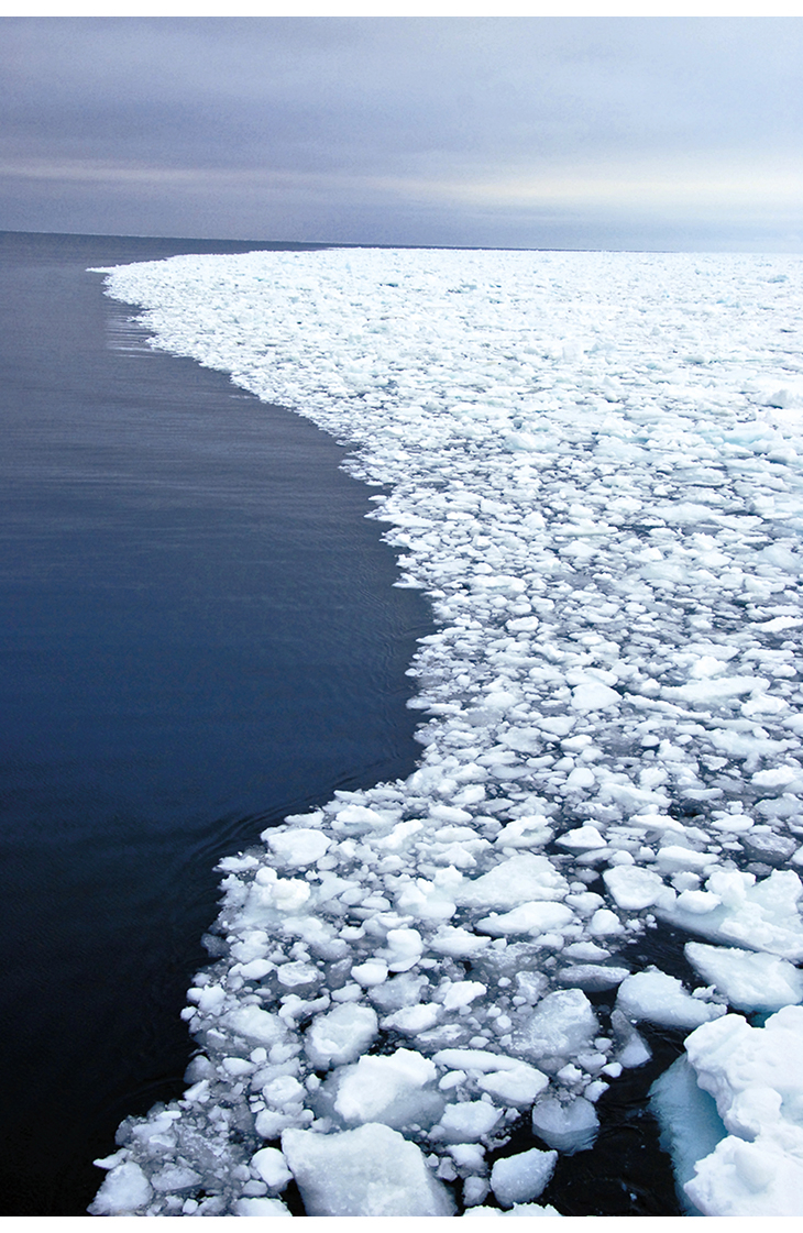
Figure 2.1 Aerial photo of the marginal ice zone in summer.
Photo: Haakon Hop, Norwegian Polar Institute.
2.1.2 Impacts on the ecosystem
Climate change
As the temperature has risen and more of the sea surface has become ice-free, the Barents Sea ecosystem has changed. Some species are benefiting from these changes, while others are being negatively affected.
The state of the environment in the Barents Sea is still generally good, but pressures and impacts on species and ecosystems related to climate change are becoming more marked. Climate change is expected to have the most serious negative impacts on species and ecosystems in the northern, Arctic part of the management plan area, including the waters around Svalbard. In these areas, climate change is the greatest threat to biodiversity. Species that are dependent on the sea ice have only limited opportunities to move further north to find suitable habitat as the sea ice melts and ice-covered areas shrink. This is because the sea ice is retreating from the shallow coastal waters and continental shelf around Svalbard to the deeper and less productive Arctic Ocean, which cannot support anything like the same level of biological production and biodiversity.
The impacts of climate change are already becoming apparent in the waters around Svalbard and in the northern Barents sea. Along the west coast of Svalbard, Arctic water has been displaced by temperate Atlantic water which supports a plankton assemblage with a different species composition. This has resulted in major changes in the marine ecosystem, and species such as capelin, herring, cod, salmon and mackerel are now periodically to be found in the fjords in this area. There are also clear signs of a northerly and northeasterly shift in the distribution of fish and whales in the Barents Sea. So far, the most striking example of a ‘climate winner’ is the cod; the population is now at a historically high level, and cod are being recorded considerably further north and east than ever before.
Ringed seals have almost ceased to breed along the west coast of Svalbard because of the lack of sea ice in whelping areas. Changes in the species composition of plankton and fish communities are also reducing the availability of food supplies for some seabirds and therefore having an impact on their populations.
Further east in Svalbard and the Barents Sea, the changes are less marked, but the number of polar bear dens in the most important denning areas has dropped sharply, probably because there is no longer sea ice in these areas in late autumn, when the pregnant females enter their dens. Shifts in the distribution of habitats and species will continue as a result of climate change and changes in sea ice extent. Key areas of habitat may become unsuitable for certain species, while new areas become much more important for species that have to move to find suitable habitat. More southerly species will gradually be able to displace Arctic species, and changes will spread to other parts of ecosystems. In marine ecosystems, changes can take place rapidly because there are few barriers to the spread of species in response to higher sea temperatures. As the climate continues to warm further, it is to be expected that the changes will become more far-reaching and involve more and more species.
Climate change may also amplify the impacts of other pressures and threat factors. The cold water of the northern Barents Sea has formed a natural barrier to the spread of alien species, but its effect is being weakened by climate change. As a result, there is a greater risk that alien species that are introduced will become established and spread here as well. In the longer term, ocean acidification is also expected to have major impacts on marine ecosystems in the Barents Sea. The greatest impacts are likely to be in the most northerly waters, partly because CO2 is more soluble in cold water. Ocean acidification will interact with climate change in ways that are difficult to predict, but that may have impacts on plankton and other key species and thus on the structure and functioning of marine ecosystems.
Pollution and marine litter
In the most northerly parts of the Barents Sea, there is little human activity that results in direct releases of pollutants. The persistent, bioaccumulative and toxic substances and radioactive pollution that are registered here have largely been transported from other regions by winds and ocean currents, following global circulation patterns in the northern hemisphere. They originate from densely populated and industrial areas further south. There are many sources, including leachate from landfills, waste water, waste incineration, agriculture and industry. Atmospheric transport is the most rapid route, and substances can be carried to the Arctic by winds in only hours or days, whereas transport with ocean currents may take several years. Pollutants are deposited on snow and ice or in the sea with rain and snow. The concentrations of environmentally hazardous substances that have been measured in sediments and during monitoring of air pollution in the Barents Sea area are generally low. Nevertheless, there is cause for concern because evidence of the spread of new substances whose use is not regulated is constantly being found. High levels of persistent, bioaccumulative and toxic substances have also been found in certain animal groups at higher trophic levels, such as seabirds and marine mammals. A wide range of such substances has been found in seabirds. Little is known about the interactions between different pollutants, but because so many different substances have been found in seabirds, there is concern that they may have health effects. This is the case even in species where the concentrations of individual substances do not exceed levels that are known to have biological effects.
In certain species, such as the glaucous gull and ivory gull, levels of persistent, bioaccumulative and toxic substances are so high that they may directly affect reproduction and survival. In polar bears, levels are high enough to affect the hormone and immune system and reproductive capacity of individual bears. The effects at population level are uncertain. Levels of the internationally regulated persistent organic pollutants (POPs), such as PCBs and DDT, are generally declining in the atmosphere and in some groups of organisms, whereas levels of substances whose use is not regulated or has been restricted only recently (for example organobromine and organophosphorus substances) are stable or rising. Cyclic siloxanes are a new group of substances of concern that have been found in the fauna in Svalbard, but so far little is known about their environmental impacts. There is only limited information about releases of siloxanes from products, but there is reason to believe that personal care products are the largest source. Cyclic siloxanes have been found in polar cod, glaucous gulls, kittiwakes and seals in Svalbard. This indicates that they can be transported over long distances to areas far from emission sources. Atmospheric monitoring has shown that levels of siloxanes in air in Svalbard are 100 to 1000 times higher than those of the ‘classical’ POPs such as PCBs and DDT. The siloxanes detected in Svalbard have almost certainly been carried with the wind from sources further south in Scandinavia and the rest of Europe.
Levels of most heavy metals (arsenic, cadmium, lead and nickel) measured in the atmosphere and precipitation in Svalbard have declined considerably since the early 1990s. However, mercury levels have remained more or less stable right up to the present. This is cause for concern, because mercury is an extremely dangerous pollutant that can pose a threat to human and animal health. Mercury is volatile, and is transported by winds and ocean currents into Arctic ecosystems and food webs. Alarmingly high levels of mercury have been found in fish, birds, marine mammals and polar bears in Arctic areas.
The problem of mercury pollution has a number of causes. There are both natural and anthropogenic sources. Although mercury releases caused by human activity have been greatly reduced in Europe and North America, climate change will allow the remobilisation of mercury that has been stored for example in ice and permafrost. Mercury bioaccumulates along food chains, and species at high trophic levels such as fish and mammals are therefore particularly liable to accumulate levels of mercury that can have health effects.
Levels of hazardous substances, including radioactive substances, are generally low in the species used as indicators of seafood safety. The only exceptions are the content of certain POPs in cod liver and POPs and mercury in Greenland halibut from certain areas.
Ocean currents transport large quantities of marine litter, which may sink to the seabed or remain floating on the surface. Beach litter is registered systematically at two sites on the west coast of Svalbard. The Governor of Svalbard also organises beach clean-up campaigns each summer. Marine litter is a threat to animal life, and both seabirds and marine mammals can be injured or become entangled in fishing gear and other litter. In addition, seabirds and other animals ingest litter, either directly or with their prey. Litter can block the gut, weakening or killing animals. There has been a steep rise in the proportion of fulmars in Svalbard that have plastic debris in their stomachs. One study found plastic in the stomachs of 88 % of the 40 fulmars analysed. In 23 % of the birds, the quantity of plastic particles exceeded the ecological quality objective set by OSPAR (less than 10 % of birds have more than 0.1 g plastic in the stomach). Microplastics, meaning plastic objects or fragments below 5 mm in size, are found in large quantities in almost all sea areas across the world. Zooplankton can mistake these tiny particles for food and ingest them, and several studies have concluded that microplastics enter the food chain in this way. A great deal of research is now being done on the effects of microplastic pollution on people and animals.
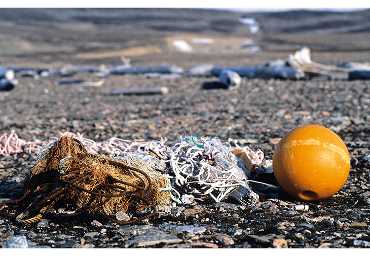
Figure 2.2 Beach litter in Svalbard.
Photo: Tor Ivan Karlsen, Norwegian Polar Institute.
Ocean acidification
Ocean acidification occurs when the quantity of atmospheric CO2 dissolved in sea water increases. CO2 reacts with water to form carbonic acid, making the seawater more acidic (lowering the pH). Higher levels of CO2 and lower pH in the ocean will also mean that calcium carbonate dissolves more readily in seawater, with particularly severe impacts on living organisms that build calcium carbonate shells and skeletons. Calcifying phyto- and zooplankton species, corals and molluscs are among the organisms expected to be adversely affected. Regular monitoring of ocean acidification in the Barents Sea along a transect from the mainland to Svalbard was started in 2010, and the northeastern Barents Sea was included from 2013. Ocean acidification has not been part of the indicator set for monitoring of the Barents Sea until now, but will be included in the course of 2015. Given the wide natural variability of pH and the short time series, it is difficult to quantify a long-term trend in acidification. However, a comparison of recent and historical data from the Lofoten Basin shows that pH dropped by 0.07 units from 1981 to 2009. In future, ocean acidification may have far-reaching impacts on marine ecosystems. CO2 is most readily soluble in cold water. Acidification is therefore expected to be most rapid in the Arctic waters north of the polar front.
2.1.3 Specific ecosystem components
Phyto- and zooplankton
The species groups of phytoplankton that are most abundant in the Barents Sea vary between seasons and between years. There is typically an intense phytoplankton bloom in spring to summer when biomass increases dramatically, particularly in the marginal ice zone and near the coast. Production is higher in warmer years with little ice than in cold years with more widespread ice. After a period when there were various observations of more southerly species, no such species were recorded along the permanent monitoring transects in the Barents Sea (Fugløya–Bjørnøya and west of Bjørnøya) in the period 2011–13.
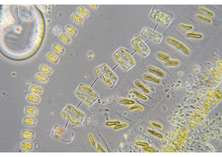
Figure 2.3 Microscopic algae in the marginal ice zone. Common phytoplankton species in a spring bloom.
Photo: Cecilie von Quillfeldt, Norwegian Polar Institute
Zooplankton biomass appears to have been fairly stable over the past 10 years, but the relatively small quantitative variations nevertheless reflect changes marked enough to have a considerable impact on species that graze on zooplankton. After a gradual decline over the three years 2007, 2008 and 2009, there was a clear rise in the quantity of zooplankton in 2010. Since then, biomass has been more variable. In 2013, zooplankton biomass appears to have been lower than before, although there was little change in spatial distribution from the preceding years. The total quantity of zooplankton was in fact lower than in any year since 1992. Numbers of the copepod Calanus finmarchicus have been relatively stable, while numbers of the larger Arctic species Calanus hyperboreus and Calanus glacialis have declined. However, the variability is within normal limits. The quantity of krill was above the long-term mean in 2013. The quantity of zooplankton is of key importance in marine ecosystems, among other things for trends in the major pelagic fish stocks.
The seabed and benthic fauna
Benthic animals of a variety of species groups live in, on or just above the seabed, and may be motile or sessile. Benthic animals are found in large numbers north of the marginal ice zone (for example brittlestars and various types of corals), on the slopes between the deep water of the Norwegian Sea and the bank area Nordkappbanken (Geodia sponges) and on the bank areas (sea urchins and sea cucumbers). There is a sharp boundary (the ‘benthic polar front’), which is linked to the marginal ice zone, between a more southerly benthic community in an area including the Bjørnøyrenna channel and a more northerly one in an area including the deeper water of Hopendypet. As the ice retreats northwards as a result of higher sea temperatures, the distribution of commercial fish species will expand. Observations also show that the distribution of the shrimp Pandalus borealis is shifting northeastwards. These changes may influence the distribution of various types of fisheries activities in the Barents Sea. Benthic animals are affected by bottom trawling, anchors and chains, invasive alien species (species that graze on the benthos and compete for space and prey), climate change and pollution.
One benthic organism that is considered to be a newcomer in the Barents Sea is the snow crab, which has been spreading westwards in the Barents Sea from further northeast. It is still uncertain whether it was originally introduced by human activity or whether we are witnessing a natural expansion of its range from the Bering Sea and the coast of eastern Siberia. Climate change may have made it possible for the species to expand its distribution in this way. The largest numbers of snow crabs ever registered in Norwegian waters were recorded in the Norwegian part of the central Barents Sea in 2013. However, the main concentration of snow crabs in the Barents Sea is still further east, in Russia’s economic zone. Russian scientists estimate that in 2013, the snow crab population was about 10 times the size of the red king crab population. It seems likely that the snow crab will end up with a more northerly distribution than the red king crab, and it will probably be possible for snow crabs to become established in the waters around Svalbard. Both the snow crab and the red king crab are occupying a niche in the Barents Sea ecosystem where there are few competing species, but they have a considerable impact on their prey species. Moreover, native species such as the northern stone crab (Lithodes maja), hermit crabs and Hyas species are found in relatively small numbers, although there may be considerable concentrations locally. The rising numbers of snow crabs may have substantial impacts on the benthic ecosystem in the Barents Sea, and the species is expected to play an important role in this ecosystem in future.
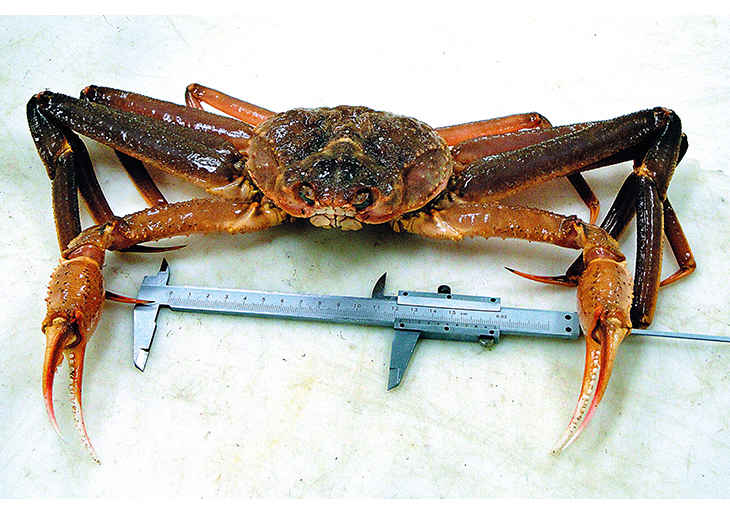
Figure 2.4 Snow crab. The first specimen found near Svalbard.
Photo: Jan Sundet, Institute of Marine Research.
In 2015, the MAREANO programme is to start mapping a long transect of the seabed from the Bjørnøyrenna channel to the island of Hopen. In time, the results will give us a better picture of variations in biodiversity and biological production in the Barents Sea, including variations across the marginal ice zone.
Fish stocks
One of the species that has benefited from rising sea temperatures is the cod. The spawning stock of Northeast Arctic cod has been rising since 2001 and is now at a historically high level. In 2012, cod were recorded further north than ever before, at 82° 30’N in shallow water north of Franz Josef Land. During the Norwegian-Russian ecosystem survey in autumn 2013, cod specimens were also found further east than ever before, in the northern Kara Sea. Another important fish species in the Barents Sea is the haddock, which is also now present in large numbers and has expanded eastwards and northwards. The rising sea temperature and availability of more food has made it possible for both cod and haddock to expand into previously cold and less productive areas. The capelin and shrimp stocks – both of these are important prey species for cod – are in good condition. Polar cod numbers have been relatively low in recent years, but the stock estimate is very uncertain. This is a key species in the Barents Sea ecosystem, particularly in the marginal ice zone. Mackerel have also been expanding their range northwards in the last few years, and have been registered as far north as Svalbard.
Monitoring shows that most fish stocks are in good condition, but the stocks of golden redfish and Greenland halibut are at low levels. The directed fishery for golden redfish has been stopped. There have been restrictions on fishing for Greenland halibut for the past 20 years, and there are indications that the stock is increasing. However, stock estimates for the species are uncertain, and have mainly been used as an indication of trends. Work on the methodology is continuing so that better stock estimates can be obtained for Greenland halibut.
Textbox 2.2 Polar cod as a key species
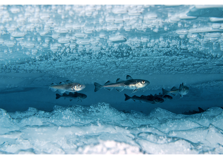
Figure 2.5 Polar cod.
Photo: Peter Leopold, Norwegian Polar Institute.
Many Arctic food chains are short and simple, with few species and links between them, but large populations of the species that are present. Certain animals are regarded as key species; they play a central role in the ecosystem, and are prey for a variety of other species. The polar cod is one such species, and is very important for energy transfer through the marine ecosystem. It is the main prey species for fish-eating seabirds in the Arctic and an important part of the diet of seals and whales. The cod stock in the Barents Sea feeds on polar cod as well as capelin.
Marine mammals
Both the declining extent of the sea ice and the delay in ice formation on the fjords around Svalbard until later in the season have had negative impacts on ice-dependent marine mammals. The has affected ringed seals particularly severely, and pup mortality has risen as a result of poor breeding conditions. A declining ringed seal population affects polar bears in turn, since ringed seals are their most important prey. The effects are most marked in Svalbard’s fjords, where ice conditions have been so poor since 2005/2006 that there has been widespread reproductive failure.
Female polar bears dig maternity dens in late autumn, in banks of snow on land. Monitoring of denning areas on Hopen and Kongsøya islands shows clearly that few females appear in these areas in autumn if the sea ice forms late. The number of days of sea ice cover round all the five most important denning areas has shown a dramatic decline over time since 1979. Data from the annual mark-recapture studies indicate a gradual decline in cub production, but it is uncertain whether this reflects a population-wide trend, or is only happening more locally in the areas covered by the studies. In 2004, the Svalbard–Barents Sea population of polar bears was estimated at between 1900 and 3600 animals. A new survey is to be carried out in 2015.
Since 2005, harp seal pup production has dropped by about 50 % compared with the level in the period 1998–2003.
The main distribution area of baleen whales has shifted further north in recent years, to the northerly shallow waters east of the island of Nordaustlandet and northeast of the Svalbard archipelago. White-beaked dolphins are now being observed far north of the polar front.
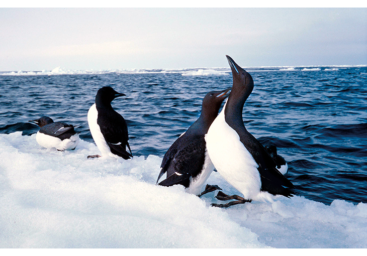
Figure 2.6 Brünnich’s guillemots.
Photo: Sebastian Gerland, Norwegian Polar Institute.
Seabird populations
The Barents Sea populations of a number of seabirds constitute a substantial proportion of the European populations, and the total breeding population of seabirds in the Barents Sea is estimated at about 12 million. If non-breeding birds (including juveniles) that use the sea area during summer are included, the number rises to about 20 million. Because the Barents Sea is shallow and highly productive, the distribution of seabirds is not as strongly linked to proximity to the coast as it is in the Norwegian Sea, and large concentrations of seabirds, for example Brünnich’s guillemots, are also found in the open sea.
The distribution of seabirds in the Barents Sea is governed mainly by climatic, oceanographic and biological conditions, with a particularly marked gradient from southwest to northeast, from warm, saline Atlantic water in the southwest to cold, less saline Arctic water in the north and east. The polar front is an important feeding area for seabirds, and the distribution patterns of the different seabird species reflect the distribution of the water masses and the location of the polar front. There is a particularly striking difference between the species mix along the Norwegian mainland coast and in the Svalbard area. There are more species, both breeding and wintering, along the mainland coast than further north. Species such as shag, cormorant and gannet were previously found only along the mainland coast (the first gannets bred on Bjørnøya in 2011), whereas glaucous gulls, ivory gulls and little auks only breed on the islands in the northern Barents Sea. The high biological production in the marginal ice zone is important for seabirds at certain times of year, for example just before the breeding season, when species such as Brünnich’s guillemot feed there. Other species such as little auk, black guillemot, fulmar and ivory gull also use the marginal ice zone.
Seabirds are considered to be good indicators of change in marine ecosystems. They are easily visible elements in an environment where most animals and plants live below the water surface, they are generally easy to count, and they concentrate in large colonies during the breeding season and often in large numbers in productive marine ‘hotspots’ outside the breeding season. Monitoring seabird populations provides a basis for managing them, and also gives an indication of the availability of food supplies (biomass of prey) in the waters around breeding colonies. Some species have shown a much more dramatic population decline than others; numbers of Brünnich’s guillemots on Bjørnøya and in other parts of the Svalbard archipelago have dropped by 25–50 % since the mid-1990s, whereas kittiwake numbers on Bjørnøya and Spitsbergen have remained stable or shown a positive trend in recent years. Regular counts of seabirds as part of the environmental monitoring programme for Svalbard and Jan Mayen (MOSJ) and the mapping and monitoring programme for seabirds, SEAPOP, are carried out along the west coast of Svalbard and on Bjørnøya. There is only limited information on seabirds from the islands of Øst-Spitsbergen and Nordaustlandet, apart from general information on the breeding colonies. It is not possible to give any specific information on the most northerly areas because of a lack of up-to-date figures.
Almost all seabird populations are showing some degree of decline, both over the last ten years and for the entire period over which monitoring has been carried out.
Textbox 2.3 Ivory gull
The ivory gull is one of Norway’s most ice-dependent species. It is a high-Arctic species, breeding for example in eastern Spitsbergen and Nordaustlandet. There are known to be almost 80 colonies in Svalbard, but not all of them are used every year. Ivory gulls feed on fish and crustaceans in the marginal ice zone, and also on carrion left by polar bears and Arctic foxes. Because of its preferred habitat and diet, the ivory gull is considered to be a good indicator of the impact of declining sea ice extent and changes in sea ice distribution in the Arctic. Its population has shown a severe decline in Canada and southern Greenland, probably because of sea ice changes combined with high levels of contaminants.
The ivory gull is one of the species included in the MOSJ and SEAPOP monitoring programmes. Recent observations support the hypothesis that the species is declining in the Barents Sea area. As the distances between breeding sites and suitable foraging areas increase, the effects on ivory gulls are expected to include poorer condition and lower breeding success, and that the birds are forced to use less optimal foraging areas and prey. Satellite telemetry studies of Norwegian (Svalbard) and Russian ivory gulls indicate that the marginal ice zone is a very important foraging area throughout the daylight months of the year, and especially in spring and autumn.
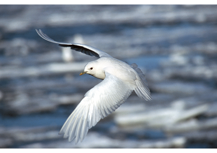
Figure 2.7 Ivory gull.
Photo: Bjørn Frantzen, Norwegian Polar Institute.
Threatened species
The Norwegian Biodiversity Information Centre has been responsible for publishing the Norwegian Red List for species since 2006. The number of species classified as threatened in the Barents Sea–Lofoten area rose between 2006 and 2010. The most important pressures on species and habitats are harvesting, habitat degradation and pollution. In addition, climate change is an important pressure on a number of red-listed species, particularly in the northern parts of the Barents Sea. A new edition of the Red List for species will be published in 2015, and this will show whether the status of the species assessed has changed. The first Red List for ecosystems and habitat types was published in 2011. The red-listed habitat types include three that are found in the deep-water areas of the Barents Sea: coral reefs (vulnerable, VU), coral gardens (near-threatened, NT) and Radicipes coral gardens (vulnerable, VU). Various other species, species groups and habitat types have also been assessed for the two red lists, but a lack of information makes it difficult to decide which red list category is appropriate. For example, cold seeps and 42 species of sponges and anthozoans have been placed in the category data deficient (DD). A new classification system for ecosystems and habitat types in Norway has been devised, but it does not include Arctic marine ecosystems associated with sea ice or Arctic coastal waters as separate habitat types. They were therefore not assessed for the Red List of ecosystems and habitat types. However, on the basis of currently available information it seems clear that ecosystems associated with Arctic sea ice are threatened by climate change in the Norwegian part of the Arctic. The classification system for ecosystems and habitat types is being revised, and habitat types associated with sea ice are being considered in this connection.
Alien species
Alien species are species or other taxa occurring outside their natural range (past or present) and dispersal potential through human agency (adapted from the IUCN definition). In global terms, the spread of invasive alien species is regarded as one of the most serious threats to biodiversity. In marine ecosystems, shipping is considered to be one of the main causes of the spread of alien species (through discharges of ballast water and hull fouling). Alien species can alter the natural species composition in an area and thus the local ecosystem. In the Barents Sea, alien species are still mainly found in waters along the mainland coast of Norway rather than in the open sea. The red king crab is the only alien species that is monitored annually in the Norwegian part of the Barents Sea. New estimates show a general population decline since 2004.
The cold, Arctic water of the northern Barents Sea forms a natural barrier to the spread of alien species from further south. However, its effect is being weakened by climate change and rising sea temperatures. As a result, there is a greater risk that any alien species that are introduced will become established and spread in these waters as well. At present, we do not know of any alien species that have been introduced with shipping and have become established in the northern part of the Barents Sea. Only a limited number of alien species have been reported in the Arctic. Of these, the wrack Fucus evanescens, the blunt gaper Mya truncata, the gooseneck barnacle Lepas anatifera and the ascidian Molgula manhattensis have been registered around Svalbard.
2.1.4 Overall evaluation
The state of the environment in the Barents Sea–Lofoten area is generally good, but the shrinking extent of the sea ice, the decline in seabird populations and the appearance of new species in the benthic fauna are all cause for concern. The declining extent of the sea ice and the fact that the fjords around Svalbard do not freeze until later in the season has had negative impacts on ice-dependent marine mammals. The problems have been particularly severe for the ringed seal, and pup mortality has risen as a result of poor breeding conditions. A drop in the number of ringed seals affects food supplies for polar bears. The reduction in sea ice extent in the Barents Sea also means that it is further from the whelping areas for harp seals in the White Sea to important feeding areas in the marginal ice zone. This may be a contributory factor in the substantial decline in pup production in the Barents Sea stock of harp seal in recent years.
Variations in plankton biomass have remained within the range found in historical data, although the large Arctic copepod species are showing a northward shift in their distribution. The same is true of the shrimp Pandalus borealis. The cod stock is at a historically high level, the capelin stock is stable and healthy, and the haddock stock is also satisfactory. There are clear signs of a northerly and northeasterly shift in the distribution of fish and whales in the Barents Sea. It is uncertain how far into the Arctic Ocean this shift will continue for demersal fish species such as cod and haddock. Together with the declining extent of the sea ice, shifts in the main distribution areas for plankton, fish and marine mammals may alter living conditions for the benthic fauna and seabirds as well.
Concentrations of environmentally hazardous substances in the Barents Sea area are generally low, with the exception of the levels of some substances measured certain fish species and top predators. In some top predators, for example polar bears, levels of persistent, bioaccumulative and toxic substances are high enough to have negative effects on health. A wide range of such substances has been found in seabirds. Little is known about the interactions between different contaminants, but because so many different substances have been found in seabirds, there is concern about possible negative effects. This is the case even in species where the concentrations of individual substances do not exceed levels that are known to have biological effects. Levels of hazardous substances, including radioactive substances, are generally low in the species used as indicators of seafood safety, with the exception of Greenland halibut. Climate change may influence the transport and release of hazardous substances and how they accumulate in fish and other animals.
Harvesting, habitat degradation, climate change and pollution are currently the most important pressures on species and habitat types in the Barents Sea–Lofoten area as a whole. In the northern part of the Barents Sea, climate change as a result of rising global greenhouse gas emissions is the predominant cause of changes that are influencing species and ecosystems. These changes are expected to continue and become more marked, and more severe negative impacts can be expected, particularly for species and ecosystems in the northern parts of the Barents Sea. In future, ocean acidification is also expected to have far-reaching impacts on marine ecosystems.
In 2011, the following conclusions were drawn as regards cumulative environmental effects on marine ecosystems in the Barents Sea–Lofoten area as a whole:
‘Given normal circumstances and the current level of activity, harvesting is expected to have the greatest impact on fish stocks of all the activities in the management plan area, while maritime transport and oil and gas activities are expected to have little impact. However, activity in these sectors is growing and may result in increasing pressure.
In the years ahead, the cumulative effects of climate change, ocean acidification and long-range transport of pollutants will probably increase and have more serious implications than the impacts of different human activities in the Barents Sea–Lofoten area. Because of uncertainties and poor documentation of several factors, it is not possible to draw definite conclusions on the cumulative effects on the ecosystem of all human activities combined. However, a combination of several significant environmental pressures in the same area at the same time increases the risk of negative impacts. For example, a permanent change in sea temperature and pH could result in change on such a scale that the ecosystem reaches a tipping point and there is an irreversible regime shift. This means that there are major, permanent changes in the structure, functioning and productivity of the ecosystem. The consequences of such changes are difficult to predict, but may be far-reaching.’
Since 2011, seawater temperatures have remained high, and this is the most important factor driving environmental change in the Barents Sea, particularly in the more northerly areas. This update of the management plan does not include a new overall assessment of the impacts of activities in various sectors or the cumulative environmental effects on the ecosystems of the Barents Sea. The scientific work in the period up to the revision of the management plan in 2020 will include such an assessment.
In conclusion, the state of the environment in the Barents Sea–Lofoten area is generally good, but considerable ecosystem change is taking place in the northern parts of the area as a result of climate change.
2.2 Particularly valuable and vulnerable areas
Particularly valuable and vulnerable areas are those that on the basis of scientific assessments have been identified as being of great importance for biodiversity and biological production in the entire Barents Sea–Lofoten area. Areas may for example be identified as particularly valuable and vulnerable because they are important habitats or spawning grounds for fish, important habitats for seabirds and marine mammals, or contain coral reefs. Areas were selected using predefined criteria. The main criteria were that the area concerned was important for biodiversity or for biological production. In addition, a number of secondary criteria were evaluated, for example economic, social and cultural importance, and scientific value.
The vulnerability of the species and habitat types in the areas identified has been assessed with respect to fisheries, shipping and petroleum activities, and in addition to climate change and pollution. The vulnerability of an area is considered to be an intrinsic property of the species and habitats to be found there, regardless of whether or not specific environmental pressures are actually acting on them.
A number of particularly valuable and vulnerable areas were identified in the Barents Sea–Lofoten area. In the northern part of the Barents Sea, these are the marginal ice zone, the polar front and the sea areas surrounding Svalbard (see Figure 2.8).
The particularly valuable and vulnerable areas, which contain especially valuable environmental components, were mapped and delimited during work on the management plans. The designation of areas as particularly valuable and vulnerable does not have any direct effect in the form of restrictions on commercial activities, but indicates that these are areas where it is important to show special caution. They have been used as a basis for setting an overall framework for activities. To protect particularly valuable species and habitats, it is for example possible to use current legislation to make activities in such areas subject to special requirements. Such requirements may apply to the whole of a particularly valuable and vulnerable area or part of it, and must be considered on a case-by-case basis for specific activities.
2.3 The marginal ice zone
2.3.1 The marginal ice zone as a particularly valuable and vulnerable area
The marginal ice zone is not in practice a sharp boundary between the open sea and concentrated drift ice, but a dynamic transitional zone that varies in width depending on wind and currents. Its geographical location varies a great deal seasonally; the maximum extent of the sea ice is generally reached in April and the minimum in September. There are also considerable interannual variations in both sea ice extent and the position of the marginal ice zone.
The earlier versions of the Barents Sea–Lofoten management plan describe the marginal ice zone as a particularly valuable and vulnerable area. In the 2006 and 2011 white papers, this area was delimited and its variable extent (the area across which it moves during an annual cycle) was shown on maps.
For the purpose of the management plan, the marginal ice zone as a particularly valuable and vulnerable area has been delimited using statistical methods of expressing satellite observations of variations in sea ice extent through the year for a series of years.
Since 1979, there has been a clear long-term negative trend in sea ice extent at all times of year (see Figures 2.19 and 2.20). The delimitation of the marginal ice zone as a particularly valuable and vulnerable area in the 2006 and 2011 white papers is based on ice data for the period 1967–89. This is no longer representative of current ice conditions. The Government has therefore updated the delimitation of the marginal ice zone as a particularly valuable and vulnerable area using ice data for the period 1985–2014. The updated delimitation of the marginal ice zone is shown on the maps in Figures 2.8 and 2.23.
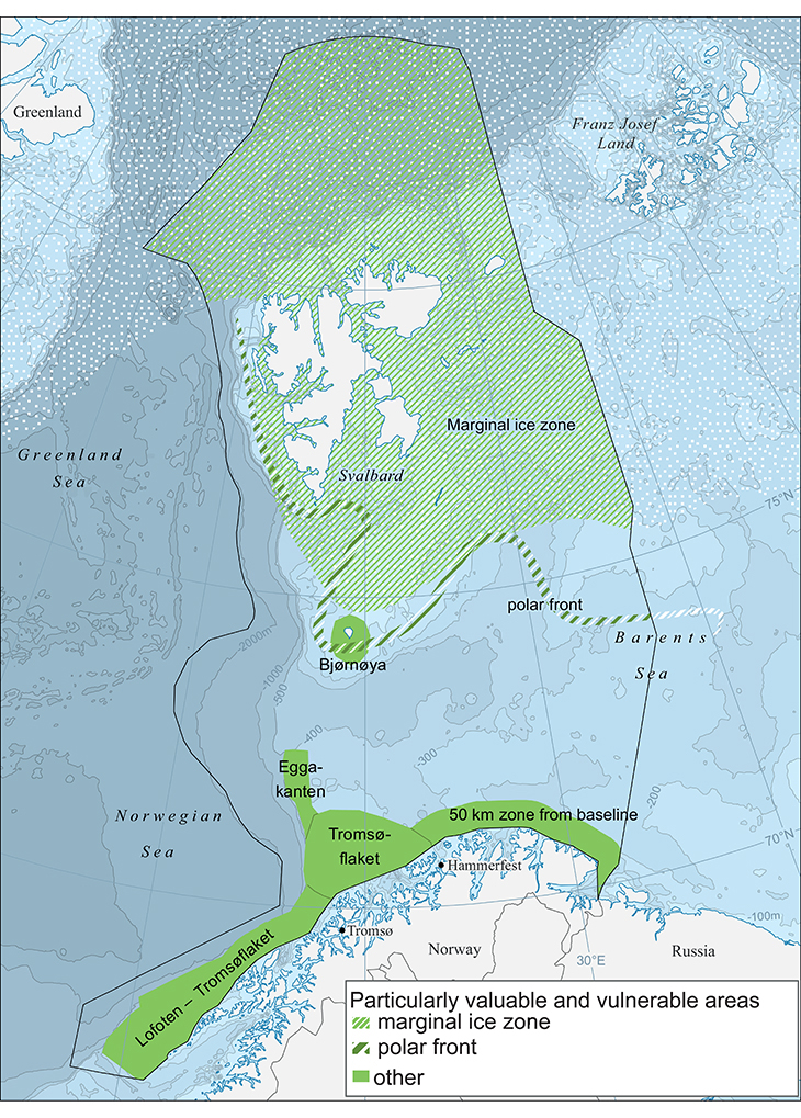
Figure 2.8 Particularly valuable and vulnerable areas in the Barents Sea–Lofoten management plan area. The delimitation of the marginal ice zone has been updated using data on sea ice extent for the period 1985–2014.
Source Norwegian Polar Institute.
Thus, the expression ‘marginal ice zone’ is used both to refer to the natural phenomenon and as the name of the particularly valuable and vulnerable area. Where there is a risk of confusion, the latter is referred to as ‘the marginal ice zone as a particularly valuable and vulnerable area’.
2.3.2 The ecosystem of the marginal ice zone
The marginal ice zone is a transitional zone between ice-free and ice-covered sea; it is influenced by waves and swell and there is enhanced ice drift and fracturing of the ice. This zone varies in width from a few hundred metres to several tens of kilometres. The breadth depends on wind direction: a northeasterly wind results in a broad, diffuse marginal ice zone, whereas southerly winds result in a narrower, more clearly defined marginal ice zone. There are also differences between the marginal ice zone during the summer while the ice is retreating and during the winter as more of the sea freezes and the extent of the sea ice increases. The satellite images in Figures 2.9 and 2.10 illustrate the appearance of the marginal ice zone in April, when the sea ice extent reaches its maximum.
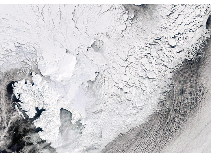
Figure 2.9 Satellite image of ice cover east of Svalbard on 19 April 2013. The image shows a system of large and small ice floes with leads and openings between them that extends far into the drift ice from the fractured outer part of the zone. The fast ice in some of the fjords of Svalbard is also visible. The image also shows clouds, which can be confused with ice.
Source MODIS, NASA Worldview.
At all times of year, the marginal ice zone forms a belt several thousand kilometres long extending through the Barents Sea, and it advances and retreats several hundred kilometres in an annual cycle driven by seasonal variations in sea and air temperatures. The sea ice reaches its maximum extent in spring, usually in April. During the summer, the marginal ice zone gradually moves northwards. By the time the sea ice extent reaches its annual minimum, normally in September, the Barents Sea is generally more or less ice-free and the marginal ice zone is located some way north of Svalbard. There may be wide interannual variations in ice extent. The location of the marginal ice zone in September can vary by several hundred kilometres from one year to another. Interannual variations in ice extent may also be large in the winter and spring months, particularly in the eastern part of the Barents Sea. Figures 2.11 and 2.12 show the actual location of the edge of the marginal ice zone in the Barents Sea for each of the last 10 years up to 2014 in April and September respectively. The figures also show that the updated delimitation of the marginal ice zone as a particularly valuable and vulnerable area encompasses the seasonal variation in sea ice extent measured in the past ten years.
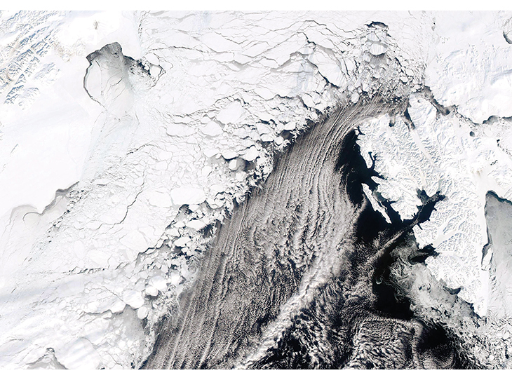
Figure 2.10 Satellite image of ice cover west of Svalbard on 11 April 2013. The image shows a system of large and small ice floes with leads and openings between them that extends far into the drift ice from the fractured outer part of the zone. The fast ice in some of the fjords of Svalbard is also visible. The image also shows clouds, which can be confused with ice.
Source MODIS, NASA Worldview.
As the ice melts and retreats northwards during the spring and summer, this creates light conditions and nutrient availability in the marginal ice zone that result in a concentrated phytoplankton bloom. The bloom of ice algae in the lowermost part of the sea ice can start up to two months before the phytoplankton bloom, as soon as there is sufficient light in the spring. This prolongs the productive season in areas where there is sea ice, and a number of grazing species have adapted to this situation. The longer productive season together with the importance of the sea ice as a habitat for many species, whether for foraging, shelter or reproduction, make the marginal ice zone a biologically important and valuable area.
From April to September, the productive zone moves northwards through the Barents Sea and provides food for plankton, fish, seabirds and marine mammals. Because the high level of biological production at any time is generally restricted to a zone a few tens of kilometres wide, there may be very high concentrations of grazing species in the marginal ice zone. A number of the species and populations found here are of international and/or national conservation value, are threatened species, species for which Norway has a special responsibility (25 % or more of the European population is found in Norway), or are key species in the Barents Sea ecosystem.
Although biological production is only high in the marginal ice zone in spring and summer, this zone and other areas of sea ice are also a very important habitat for a number of ice-dependent species throughout the year. Mammals to which this applies include the ringed seal, bearded seal, walrus, narwhal and polar bear. Several seabird species also spend most of the year in or near the marginal ice zone.
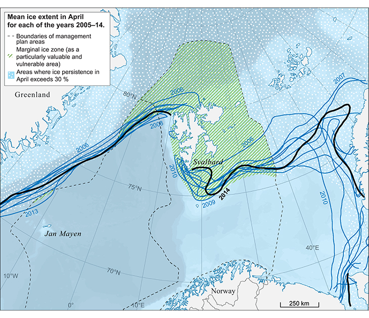
Figure 2.11 Mean ice extent in the Barents Sea in April for each of the years 2005–14. The figure shows the larger interannual variations in sea ice extent in the Barents Sea in April, particularly in the east. The hatched area shows the updated delimitation of the marginal ice zone as a particularly valuable and vulnerable area. The mean ice extent in April has been within this area in each of the past ten years. Together with Figure 2.12, this figure also shows that the delimitation of the marginal ice zone as a particularly valuable and vulnerable area encompasses the seasonal variation in ice extent measured in the past ten years.
Source Norwegian Polar Institute. Data for monthly mean sea ice extent taken from the US National Snow and Ice Data Center.
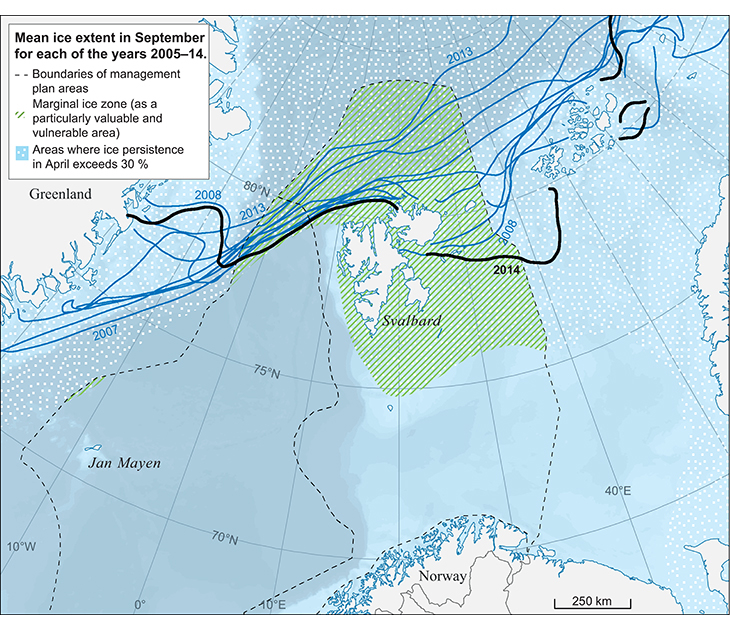
Figure 2.12 Mean ice extent in the Barents Sea in September for each of the years 2005–14. Comparing September 2013 and September 2014 shows how much the summer sea ice extent may vary from one year to another. Together with Figure 2.11, this figure also shows that the updated delimitation of the marginal ice zone as a particularly valuable and vulnerable area encompasses the seasonal variation in ice extent in the past ten years.
Source Norwegian Polar Institute. Data for monthly mean sea ice extent taken from the US National Snow and Ice Data Center.
The maximum southerly extent of the sea ice often coincides with the polar front, but not always. The polar front is the boundary zone where warm, saline Atlantic water carried by the Gulf Stream meets colder, less saline water from the Arctic Ocean. In parts of the area north of the polar front, there is relatively little biological production except for the algal bloom within the marginal ice zone as it moves northwards. As a result, it is variations in the extent of the marginal ice zone that to a large extent govern both biological production and the distribution of ice-dependent species in the northern parts of the Barents Sea. Much of the primary production in the marginal ice zone sinks to the seabed, where it can be used by benthic animals, another important component of the ecosystem and part of the diet of seals and seabirds.
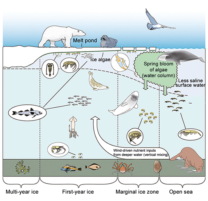
Figure 2.13 The ecosystem in the marginal ice zone during the spring bloom.
Source Norwegian Polar Institute.
Many of the species that live partly in drift ice areas are also dependent on breeding areas on land or on fast ice in the fjords of Svalbard, and on the food supplies available on the seabed in the shallow bank areas traversed by the ice. In the northern part of the Barents Sea and around Svalbard, the sea ice and marginal ice zone are on the surface of shallow waters above the continental shelf, and much of the area is also near to the coast. The combination of a productive marginal ice zone, suitable habitat in and on the sea ice and along the coast, and shallow waters giving access to nutrients on the seabed is crucial for the large numbers of seabirds and marine mammals found in the area. Thus, the sea ice plays a key role in maintaining productivity and diversity in the entire northern Barents Sea ecosystem throughout the year.
Textbox 2.4 Plants and animals in the marginal ice zone
In spring and early summer, there is intense primary production under the ice and in the water column in the marginal ice zone. As the ice melts in spring, a stable water surface layer develops containing high nutrient levels after the winter, and light penetrates the water, triggering a phytoplankton bloom.
Ice algae, which live in or on the ice itself, are also important primary producers, like the phytoplankton in the water column. The ice algae are adapted to low light levels, and their bloom starts before that of the phytoplankton. This prolongs the productive season in the marginal ice zone.
Quantities of grazing zooplankton species rise in response to the high primary production, and species that can make use of the abundant food supplies concentrate in the marginal ice zone.
As organisms die, a proportion of the biological production sinks down through the water column to the seabed, and provides the basis for rich benthic communities in ice-influenced areas.
The marginal ice zone provides abundant, predictable food supplies that are of crucial importance for the total annual energy budget (survival and reproduction) of many Arctic species. It is an important habitat and foraging area for key species in the Arctic ecosystem, such as capelin and polar cod. These two species are important prey for seabirds and marine mammals, and the marginal ice zone is therefore also an important staging area for many migratory birds and mammals, for example kittiwake, black guillemot, ivory gull, polar bear, ringed seal, narwhal, beluga and bowhead whale.
In late summer, 80–90 % of the world population of ivory gulls congregate in the marginal ice zone in the northern Barents Sea. Polar bears are found at higher densities along the outer edge of the marginal ice zone than further north. The pelagic seal species whelp on the sea ice in the marginal ice zone in early spring, closely synchronised with the algal spring bloom.
Several of these species are red-listed in Norway or internationally, and the dense concentrations of many species, sometimes in very small areas, increase the vulnerability of the marginal ice zone in periods when production is high.
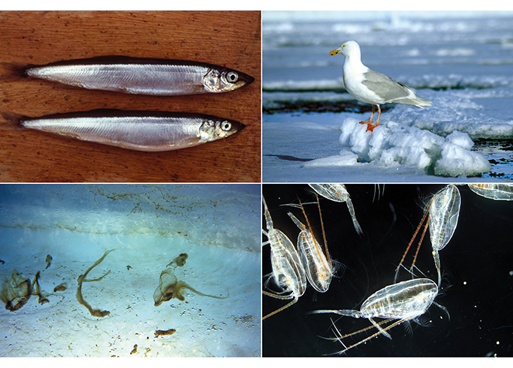
Figure 2.14 Species found in the marginal ice zone: capelin, glaucous gull, ice algae and the copepod Calanus glacialis (zooplankton).
Photos: Haakon Hop (capelin, ice algae), Tor Ivan Karlsen (glaucous gull), Allison Bailey (Calanus), Norwegian Polar Institute.
2.3.3 Vulnerability
The ecosystem of the marginal ice zone is vulnerable to climate change, hazardous substances and oil spills. Ecological vulnerability is considered to be higher across the whole breadth of the marginal ice zone from the outer limit of the ice and including entire area where light can penetrate through the ice. High concentrations of seabirds and marine mammals can be found in all parts of this zone, often near the open sea. Polar bears congregate particularly deeper into the marginal ice zone, near the transition to more tightly packed drift ice and complete ice cover.
Climate change
The ecosystem of the marginal ice zone is highly vulnerable to climate change, which is the greatest threat to Arctic species and ecosystems. Climate change will influence the timing of ice formation and ice melt. This in turn will affect the timing, location and intensity of production in the water column. A reduction in the area of sea ice available will also have an impact on ice-dependent species, and thus on production conditions and biodiversity in areas with a seasonal ice cover. There may also be ecosystem impacts if the timing of the algal bloom in the marginal ice zone changes so that it no longer coincides with the presence of important grazing species, but the consequences are very uncertain. Moreover, changes in ice conditions will have an influence on how much of the algal production under the ice and in the marginal ice zone sinks to the seabed, where it provides nutrition for benthic communities.
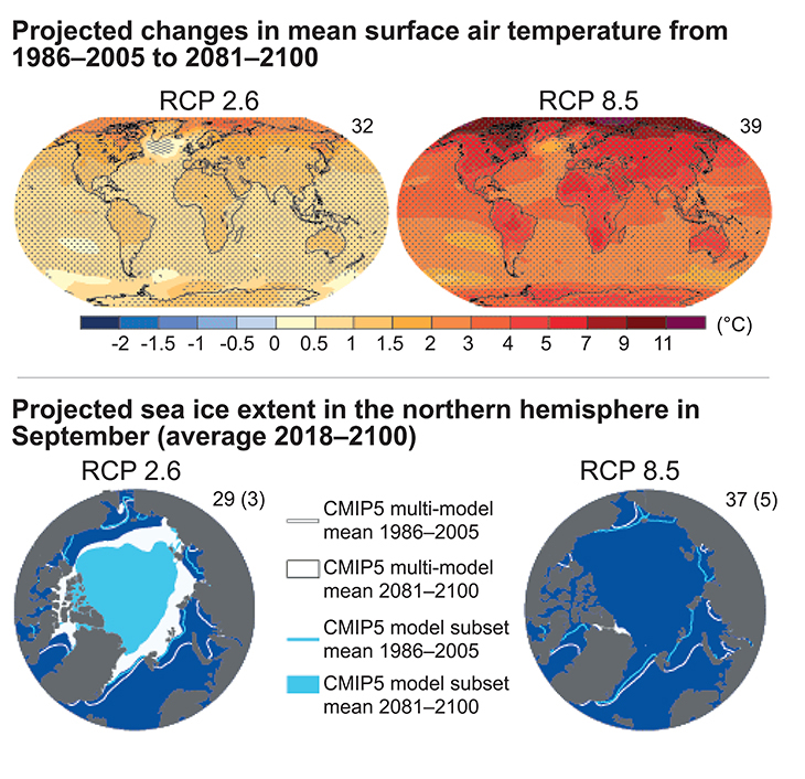
Figure 2.15 Projected changes in mean surface air temperature and sea ice extent towards the end of this century. The right-hand maps show projections for a scenario with continued high levels of greenhouse gas emissions. In this case, the Arctic Ocean is expected to be more or less ice-free in September by the middle of this century. The left-hand maps show projections for a scenario involving deep, rapid cuts in global greenhouse gas emissions. In this case, modelling indicates that there will probably still be sea ice in the Arctic Ocean in summer towards the end of this century.
Source IPCC.
The areas covered by sea ice are shrinking rapidly throughout the Arctic. According to the IPCC, the average sea ice extent in the Arctic declined by about 4 % per decade in the period 1979–2012. In summer, the decline has been about 12 % per decade. According to the IPCC, it is very likely that anthropogenic climate change has contributed to Arctic sea ice loss, and that this loss will continue. The IPCC’s modelling results indicate that further reductions in sea ice extent in future will be critically dependent on trends in global greenhouse gas emissions. Projections range from a 94 % reduction in summer sea ice extent towards the end of this century in a scenario with high emissions to a 43 % reduction in a scenario with low emissions. The projected reductions in winter sea ice extent are much smaller, ranging from 34 % to 8 %. The results using the high-emission scenario show that the Arctic Ocean will be almost ice-free in September by around the middle of this century. As Figure 2.16 shows, the level of uncertainty in these results is high. In addition to changes in sea ice extent, changes in the thickness and structure of the ice have important implications for production conditions and ice-dependent species.
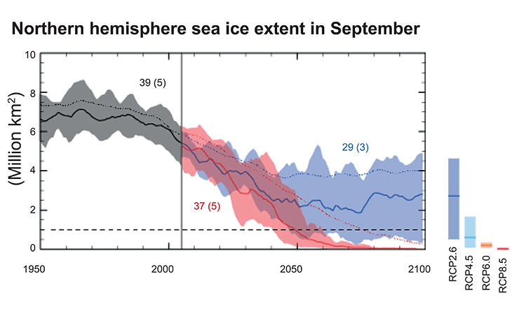
Figure 2.16 Projected changes in Arctic sea ice extent in summer up to the end of the 21st century. Projections based on a scenario with continued high levels of greenhouse gas emissions are shown in red, and projections based on deep rapid cuts in emissions are shown in blue. Solid lines show projected mean values, and the shaded areas show the uncertainty intervals. The horizontal dashed line represents more or less ice-free conditions. It can be seen from the figure that if emission remain high, the Arctic seas are expected to be almost ice-free by the middle of this century.
Source IPCC.
The Barents Sea is one of the parts of the Arctic where the sea ice is retreating most rapidly. And in contrast to the situation in other parts of the Arctic, sea ice extent is also declining rapidly in winter here (see Figure 2.19). Calculations show that within the parts of the Barents Sea that have a seasonal ice cover, the ice-free period (from the date when the ice disappears in spring and early summer to the date when it re-forms in autumn and winter) has increased considerably since 1979. During this period, the date for the disappearance of the ice in spring has become progressively earlier, by 17 days per decade. The date when the ice re-forms has become later, moving back 24 days per decade. These are far greater changes than in other parts of the Arctic, and according to the climate models they are expected to continue. This poses a serious threat to ice-dependent species such as the polar bear, which can only survive for limited periods without sea ice.
Climate change is already having clear impacts on the ecosystem of the sea ice and marginal ice zone in the Barents Sea. These changes are further described in Chapter 2.1.2.
In its most recent assessment report, the IPCC concluded that in the long term, there is a very high risk of major change in Arctic marine ecosystems. In addition to changing the distribution of species and habitats that are spatially and temporally associated with the sea ice and marginal ice zone, climate change will reduce the area of suitable habitat available to many ice-dependent species. In the longer term, a number of these may disappear from larger and larger areas of the Arctic, and the Barents Sea is one of the areas where this is expected to happen most rapidly. There will be less and less suitable habitat for ice-dependent species in the Barents Sea. Such species only have limited opportunities to move further north to find new areas where conditions are suitable. This is because the sea ice is retreating from the shallow coastal waters and continental shelf around Svalbard to the deeper and less productive Arctic Ocean, which cannot support anything like the same level of biological production.
The impacts of long-range transport of pollution, ocean acidification and human activity in the management plan area are additional to the negative impacts of climate change on many species and ecosystems. As the impacts of climate change increase, the cumulative environmental effects on these species and ecosystems will intensify. Climate change may also make ice-dependent species and ecosystems more vulnerable to other environmental pressures. The rapid pace of climate change thus poses considerable challenges for the management of activities that may have impacts on species and ecosystems in the marginal ice zone and drift ice.
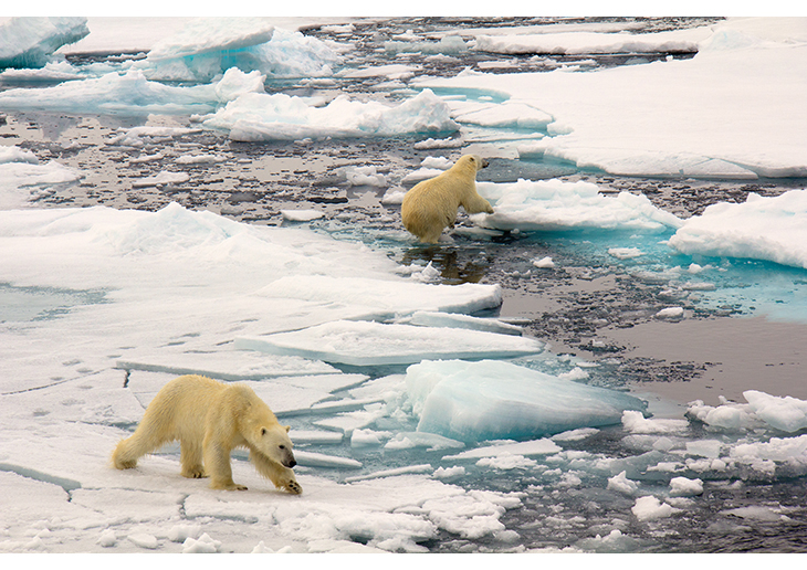
Figure 2.17 Polar bears in the marginal ice zone in the Barents Sea.
Photo: Ann Kristin Balto, Norwegian Polar Institute.
Hazardous substances
Even in the undisturbed Arctic environment, far from major sources of pollution, living organisms are exposed to hazardous substances. The fauna of the marginal ice zone is particularly at risk from persistent, bioaccumulative and toxic substances. This is mainly because such substances are transported to the Arctic with northerly winds and ocean currents and then deposited on the sea ice. However, local sources such as historical pollution or oil and chemical spills may also be significant. Modelling results from the Marine Pollution Monitoring Programme (2012) suggest that the sea ice shields the seawater from atmospheric inputs of pollutants in winter, but that they are released into the surface water when the ice melts. This can result in higher concentrations of pollutants along the ice edge in spring, where they may be absorbed by marine animals and plants. This is a serious concern because some substances bioaccumulate very effectively along Arctic marine food chains. In addition, the low temperatures in the Arctic mean that degradation processes are slower and substances persist longer in the environment. Some Arctic mammals, such as polar bears and ringed seals, are particularly vulnerable to contaminants because their life strategy includes prolonged fasting periods. During these periods, the animals draw on their fat reserves, causing a rise in the concentrations of fat-soluble contaminants in other parts of their bodies and their migration into vital organs such as the liver, endocrine glands and brain. Mammals also transfer contaminants to their young during lactation. Through these mechanisms, hazardous substances are transferred from generation to generation and remain in the environment for prolonged periods. So far, little is known about how climate change will influence the impacts of hazardous substances on marine ecosystems.
Oil spills
In the event of an oil spill, oil pollution in the marginal ice zone could affect the large numbers of seabirds and marine mammals that congregate there, and also the plankton, ice algae and fish larvae in the water column and under the ice. Polar bears, which can be found at high densities in the marginal ice zone, could also be affected in areas polluted by an oil spill. The large concentrations of seabirds and marine mammals make the ecosystem in the marginal ice zone particularly vulnerable to oil spills. There are still major gaps in our knowledge of the damage oil pollution could do to the ecosystem in the marginal ice zone, but its vulnerability is considered to be high. This ecosystem plays a key role for much of the marine life in the Barents Sea, and a large spill in the marginal ice zone could have serious impacts. The impact assessment for the Barents Sea southeast showed that a prolonged oil spill with large amounts reaching the marginal ice zone could be particularly serious for marine mammals associated with this zone. Generally speaking the probability of major spills from petroleum operations is small. The risk of oil spills from shipping and petroleum activities is discussed in Chapter 3.
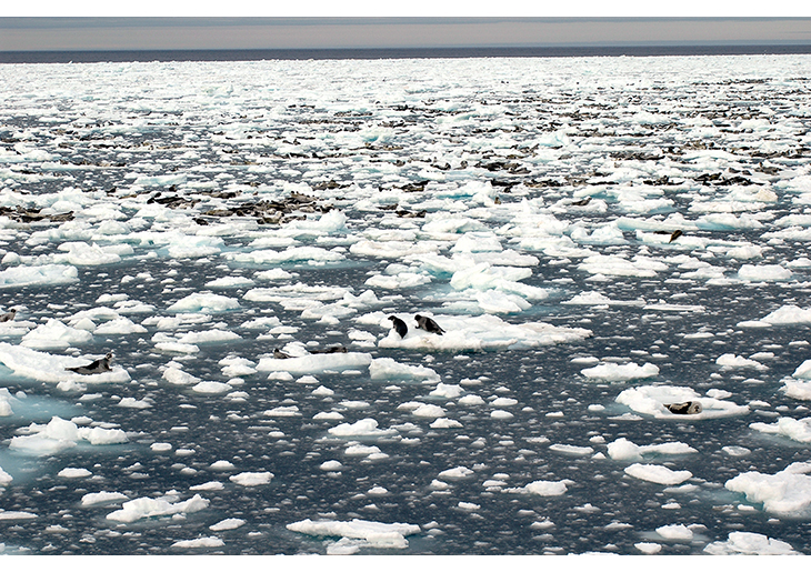
Figure 2.18 Harp seals on the ice in the marginal ice zone.
Photo: Andrea Taurisano, Norwegian Polar Institute.
Oil that is frozen into the ice can be transported with the ice as it drifts, and will be a chronic source of pollution in areas where the ice melts.
Because of the high biological production and diversity in the marginal ice zone, oil pollution in this area could affect the habitats of a large number of species and species groups. There are still major gaps in our knowledge of the damage oil pollution could do to the ecosystem in the marginal ice zone, but its vulnerability is considered to be high. The impacts could be particularly severe in the event of a major oil spill across a large are of the marginal ice zone in spring or summer, when production in the water column is very high and large numbers of seabirds and marine mammals may be concentrated in limited areas.
Seabirds that come into contact with oil are liable to freeze to death because their plumage loses its insulating properties when contaminated with oil. Many animal species are very vulnerable to oil throughout the year or at specific times of year, and are usually killed by oil contamination. This applies particularly to seabirds during the moult, seal pups and moulting seals. Other species may survive limited oil contamination. Zooplankton and the early life stages of fish are also vulnerable to oil pollution. Petroleum products contain a large number of different substances, and different products vary widely in composition, toxicity and potential for harm. Oil spills can cause either acute or chronic and potentially lethal physiological and biochemical damage, depending on the concentrations to which individual animals are exposed and the duration of the exposure.
Many factors determine whether a major oil spill has serious long-term impacts, including the time of year when it happens and the stage of animal species’ annual cycle (reproduction, feeding, etc) that is affected. Chapter 3.5 describes the special challenges involved in providing an oil spill preparedness and response system for icy waters.
2.3.4 Delimitation of the marginal ice zone as a particularly valuable and vulnerable area in the earlier versions of the management plan
In the 2006 and 2011 white papers on the management plan, the marginal ice zone was identified and described, and its variable extent was shown on maps. This zone includes the entire area of sea that normally has a seasonal ice cover, across which the marginal ice zone moves in the course of an annual cycle between the maximum and minimum extent of the sea ice.
In the management plan, the marginal ice zone has been delimited in the same way as in a report on identification of particularly valuable areas in the Barents Sea–Lofoten area, published in 2003, which formed part of the scientific basis for the 2006 management plan. In this report, the boundary of the marginal ice zone followed a line where sea ice was present on 30 % of the days in April, based on satellite observations of ice extent from the period 1967–89 (excluding 1976). The criterion used to determine whether ice was present was an ice concentration exceeding 15 %, meaning that ice covers more than 15 % of the sea surface. This frequency measure (how often ice is present in a particular month) is called ‘ice persistence’, and in the short term it expresses the probability of finding sea ice in the period of the year for which the calculations have been made.
This method for delimiting the marginal ice zone as a particularly valuable and vulnerable area is based on statistics on the presence of sea ice for a preceding period, in this case 1967–89. The particularly valuable and vulnerable area encompasses the whole area within which the marginal ice zone will normally be found as the sea ice extent varies between its annual maximum and minimum (see Figures 2.11 and 2.12). It thus covers the areas that are of greatest significance for biological production and biodiversity associated with the marginal ice zone during the course of a year.
Like the other particularly valuable and vulnerable areas, the marginal ice zone contains environmental components that are considered to be particularly valuable, and its delimitation as a valuable and vulnerable area has been fixed. In the case of the marginal ice zone, the delimitation cannot be based on a snapshot of where the ice edge is on a particular date, but must be determined on the basis of statistics on the movement and variable extent of the marginal ice zone during the year and on interannual variations in sea ice extent.
On the basis of a scientific assessment, the boundary of the marginal ice zone is considered to follow the line where there is sea ice on 30 % of the days in April. This criterion means that in the years where the sea ice extent is greatest, there may be sea ice south of the boundary of the marginal ice zone when the ice extent is near its annual maximum (see Figure 2.21).
2.3.5 Update of the delimitation of the marginal ice zone as a particularly valuable and vulnerable area
In the past 30 years, there has been a clear long-term negative trend in sea ice extent both in the Arctic as a whole and in the Barents Sea. In the Barents Sea, this decline has been observed both in summer and in winter. This can be clearly seen in Figures 2.19 and 2.20, which show trends in mean sea ice extent in the Barents Sea in April and September since 1979, based on satellite observations. The figures also show the considerable interannual variability in sea ice extent. This variability is explained by natural fluctuations, while anthropogenic climate change is believed to be the main reason for the long-term negative trend.
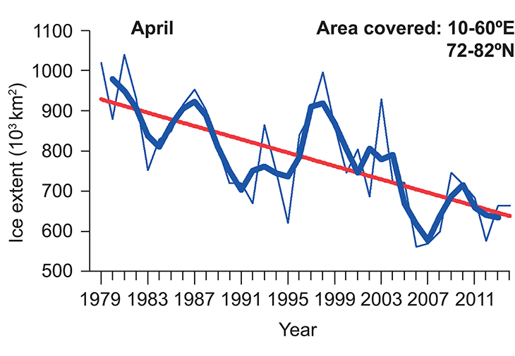
Figure 2.19 Mean sea ice extent in the Barents Sea in April, the month when sea ice extent reaches its maximum. The graph shows monthly means for each year (thin blue line), rolling average values for three-year periods (thick blue line) and the linear trend for the whole period (red line). There are large interannual variations, but also a negative trend in sea ice extent in April throughout the period. The lowest value for sea ice extent was measured in April 2006.
Source Norwegian Polar Institute.
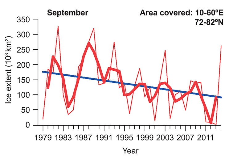
Figure 2.20 Mean sea ice extent in the Barents Sea in September, the month when sea ice extent reaches its minimum. The graph shows monthly means for each year (thin red line), rolling average values for three-year periods (thick red line) and the linear trend for the whole period (red line). There is a negative trend in sea ice extent in September throughout the period, but also large interannual variations.
Source Norwegian Polar Institute.
With the observed reduction in sea ice, the mean position of the marginal ice zone at any specific time of year is moving steadily further northwards and eastwards. This also means that the ecosystem of the sea ice and marginal ice zone and the vulnerable species and habitats associated with it are shifting in the same direction.
In the earlier versions of the management plan, the extent of the marginal ice zone as a particularly valuable and vulnerable area was delimited using ice data from the period 1967–89. This was a period when there was considerably more ice cover in the Barents Sea than is the case today. The calculations are therefore not representative of current ice conditions.
Particularly valuable and vulnerable areas should be delimited so that their boundaries reflect the areas that are of greatest importance for biodiversity and for biological production. The delimitation of the marginal ice zone as a particularly valuable and vulnerable area has therefore been updated using new ice data, so that it reflects ice conditions up to the present day.
The updated delimitation of the marginal ice zone is based on the same criteria as those used in the 2006 and 2011 versions of the management plan, so that the boundary of the marginal ice zone follows a line joining areas where sea ice is present on 30 % of the days in April. In other words, the marginal ice zone is still delimited using a minimum ice persistence of 30 %. As in the original calculations, the presence of ice means that the ice concentration – the proportion of the sea surface covered by ice – is more than 15 %. Ice data from satellite images for the 30-year period 1985–2014 have been used for the calculations. The new ice data used as a basis for updating the delimitation of the marginal ice zone are generally of better quality than the older data. A 30-year period was used to reduce the sensitivity of the updated delimitation to short-term fluctuations in ice conditions from year to year. The standard normal period used in climatology and meteorology is also 30 years. Figure 2.21 shows mean ice persistence in different parts of the Barents Sea in April for this 30-year period. Figure 2.22 shows the corresponding map for September, when sea ice extent reaches its annual minimum.
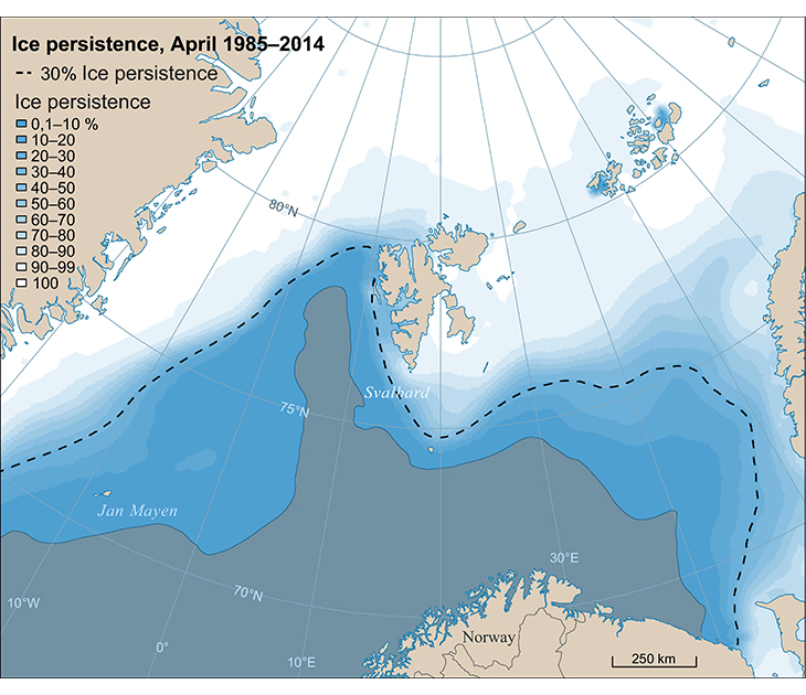
Figure 2.21 Ice persistence in April for the period 1985–2014. Sea ice extent normally reaches its annual maximum in April. Ice persistence is the percentage of days on which sea ice is present in a specific area within a specified period of time, and is further explained in the text.
Source Norwegian Polar Institute.
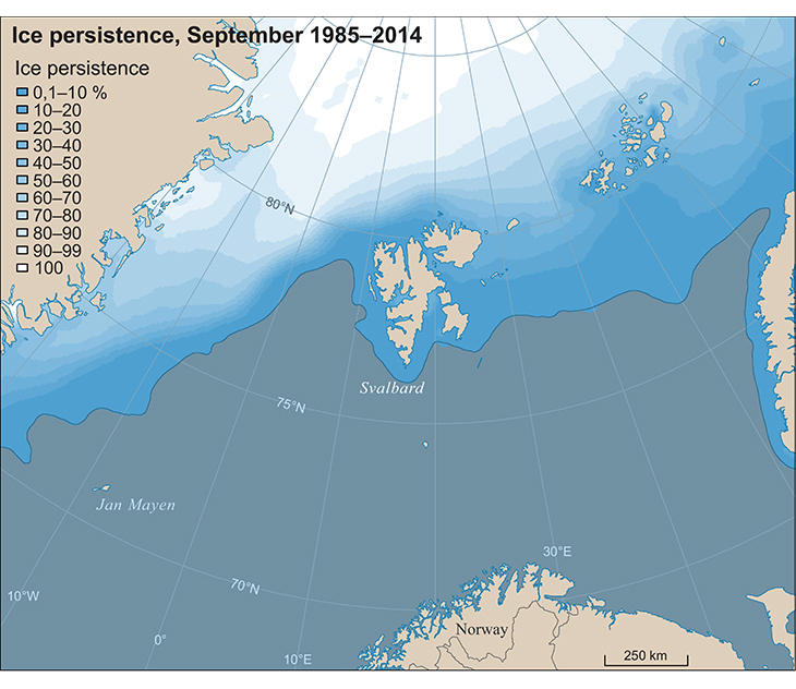
Figure 2.22 Ice persistence in September for the period 1985–2014. Sea ice extent normally reaches its annual minimum in September. Ice persistence is the percentage of days on which sea ice is present in a specific area within a specified period of time, and is further explained in the text.
Source Norwegian Polar Institute.
The calculations updating the delimitation of the marginal ice zone were performed by the Norwegian Polar Institute, and the new boundary is shown on the maps in Figures 2.8 and 2.23. The updated delimitation reflects changes in ice conditions between the periods 1967–89 and 1985–2014. The ice data used to update the delimitation are from the US National Snow and Ice Data Center, and consist of daily satellite-based measurements of ice concentration in 25x25 km grid squares. As shown by Figure 2.23, the updated boundary of the marginal ice zone runs north of the areas in the Barents Sea that have been opened for petroleum activities. However, special management measures may also be needed south of this boundary to reduce the risk of impacts on the marginal ice zone.
Textbox 2.5 Definition of the marginal ice zone as a particularly valuable and vulnerable area
The marginal ice zone as a particularly valuable and vulnerable area is defined so that it encompasses the whole area within which the marginal ice zone will normally be found as the sea ice extent varies between its annual maximum and minimum. The boundary of the marginal ice zone is considered to follow the line where sea ice is present on 30 % of the days in April, using a time series of satellite observations of ice extent for the 30-year period 1985–2014. The criterion for determining whether ice is present is an ice concentration exceeding 15 %, meaning that ice covers more than 15 % of the sea surface. This is in accordance with international standards. This frequency measure is called ‘ice persistence’, and in the short term it expresses the probability of finding sea ice in the period for which the calculations have been made (see Figures 2.21 and 2.22). The delimitation of the marginal ice zone as a particularly valuable and vulnerable area is shown in Figure 2.23.
2.3.6 Future updates and further work on the management plan
The delimitation of the marginal ice zone as a particularly valuable and vulnerable area will next be updated in connection with the revision of the management plan for the Barents Sea–Lofoten area in 2020. As part of the scientific basis for the revision, the criteria defined as the basis for delimiting the marginal ice zone will be reviewed.
It is also necessary to consider the implications of the northward retreat of the marginal ice zone in connection with the delimitation of other particularly valuable and vulnerable areas around Svalbard, and for evaluating whether they still cover the most valuable and vulnerable parts of the northern Barents Sea. This is important because climate change is resulting in rapid change in ecosystems, and patterns of human activity are also changing.
In the earlier versions of the Barents Sea–Lofoten management plan, both the polar front and the sea areas surrounding Svalbard are identified and described as particularly valuable and vulnerable areas. There is some overlap between these areas and the marginal ice zone.
The polar front is the zone where warmer Atlantic water meets cold, less saline water from the Arctic Ocean. It is a transitional zone where primary production and biodiversity are high. When the ice has advanced to its maximum extent in spring, the marginal ice zone often coincides to a large extent with the polar front. The location of the polar front, like that of the marginal ice zone, is being influenced by climate change. In the eastern parts of the Barents Sea, the polar front has receded further north and east. An assessment of whether the delimitation of the polar front as a particularly valuable and vulnerable area needs to be updated will be made when the management plan is revised in 2020.
The sea areas surrounding Svalbard, including Bjørnøya, have been identified and described as particularly valuable and vulnerable areas in the Barents Sea–Lofoten management plan. Only the area around Bjørnøya has been delimited on maps in the management plan. The scientific work in the period up to the revision of the management plan in 2020 will include an assessment of how the particularly valuable and vulnerable area around Svalbard can be delimited.
In the period up to the revision of the management plan in 2020, it will also be necessary to further develop the set of indicators for assessing environmental status, for example by including indicators for ice-dependent marine mammals.
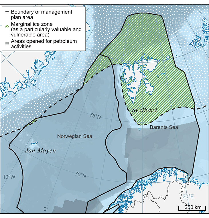
Figure 2.23 Updated delimitation of the marginal ice zone as a particularly valuable and vulnerable area based on ice data for the 30-year period 1985–2014.
Source Norwegian Polar Institute.
Footnotes
The timing of maximum sea ice extent varies depending on the area included. For the Arctic as a whole, March is the month when sea ice extent reaches a maximum, while in the Barents Sea and Fram Strait, the maximum is reached at the end of March/early April, with wide interannual variations.