3 Environmental status and trends in Norwegian waters
Environmental status in Norway’s rich, productive seas is in many respects good, but climate change is having growing impacts, and is clearly affecting the status of ecosystems in both the North Sea and the Barents Sea. In the North Sea, rising temperatures have resulted in changes in the zooplankton community and a less productive ecosystem but with higher species diversity. Species in the existing fish community may be displaced by others spreading from further south. In the Barents Sea, rising temperatures and the loss of sea ice have resulted in a rise in overall primary production, and in large parts of the management plan area, Arctic species are being displaced by more southerly species. Major changes are taking place in the ecosystem in the northern part of the Barents Sea. No such marked shifts have been registered in the Norwegian Sea, but some changes have been observed, which in the case of zooplankton can be linked to climate variability.
The ocean climate is influenced both by anthropogenic climate change and by natural variability, which can both upward and downward temperature fluctuations. Anthropogenic climate change is causing a long-term trend of rising temperatures. However, there can be considerable natural variability between years and between decades, and it is generally much larger than anthropogenic change on these time scales. In the longer term, global warming will nevertheless result in rising sea temperatures and further loss of ice cover, with major ecological impacts.
In the Barents Sea, climate change has already resulted in long-term trends of rising sea temperatures, shrinking ice cover and large-scale ecological changes, especially in the northernmost areas. So far, ocean acidification has not been registered in the Barents Sea. Apart from climate change, human activity has resulted in only minor environmental changes since 2011. The fish stocks in the Barents Sea are generally sustainably managed, and pressures on the ecosystem from activities within the management plan area are within acceptable long-term limits.
In the Norwegian Sea, the water temperature has risen as a result of climate change, and acidification has been registered. The changes observed in the species composition of zooplankton and fish communities are not as extensive as those recorded in waters further north and south, but the data for the Norwegian Sea are not as complete. There has been some variability in zooplankton and fish production, but this is now relatively high for many species, while fishing pressure has decreased since the turn of the century. Inputs of pollutants are generally stable or declining. Many seabirds have suffered a dramatic population decline since the early 1980s. Since 2006, observations of southerly species of zooplankton in the Norwegian Sea have been increasing. These are species that are common in the North Sea or further south and were previously not normally found in the Norwegian Sea.
In the North Sea and Skagerrak, climate change has been causing significant warming since as long ago as the late 1980s. The water temperature is still high, and there has been a continuing spread of southerly zooplankton species, with substantial impacts on the rest of the ecosystem. There has been a considerable decline in kelp forests in the Skagerrak in recent decades. Marine heatwaves when water temperatures are abnormally high in summer have been an important contributory factor in this decline. Many fish stocks have grown considerably in recent years, while levels of pollutants have generally remained unchanged or declined.
Impacts on an ecosystem may be linked to direct pressures and physical disturbance of the ecosystem or to large-scale processes such as climate change. The cumulative impacts on an ecosystem are the result of a range of pressures acting on it. A combination of several pressures acting together may result in more severe impacts on marine ecosystems. For example, warming of the oceans and inputs of nutrients together worsen problems related to oxygen depletion, and warmer seas and ocean acidification in combination damage coral reefs more severely than either of these factors alone.
The effects of different human activities on biodiversity are assessed using an ecosystem approach and following the principle that cumulative impacts must be assessed. To assess the cumulative impacts of a range of direct anthropogenic drivers, it is important to understand the interactions between them. Our knowledge of these interactions is limited at present, but the situation is improving. In addition to information about existing drivers, it is important to have a sound knowledge of likely environmental impacts of rising activity levels and emerging industries. We can be reasonably certain that the pressures and impacts related to climate change and ocean acidification will become considerably greater. Chapter 4 describes what is already known about the probable main features of these pressures and impacts. However, there is more uncertainty about how species and ecosystems will be affected at regional and local level. Considerable challenges are expected to arise as a result of interactions between the expected impacts of climate change and ocean acidification, and the more direct local and regional impacts of human activity at sea and along the coast. Some drivers, such as hazardous substances, ocean acidification and climate change, can influence larger areas and all trophic levels in an ecosystem. Climate change also influences how hazardous substances spread and the environmental behaviour of these substances. Organisms that are already under pressure are often more vulnerable to other pressures or an increase in cumulative impacts.
Particularly valuable and vulnerable areas
Particularly valuable and vulnerable areas are identified on the basis of scientific assessments as being of great importance for biodiversity and biological production in an entire management plan area. They are selected using predefined criteria, the main ones being that the area concerned is important for biodiversity or for biological production. The designation of areas as particularly valuable and vulnerable does not have any direct effect in the form of restrictions on commercial activities, but indicates that these are areas where it is important to show special caution.
New knowledge has been obtained about species, habitats and vulnerability in the particularly valuable and vulnerable areas. Research, mapping and monitoring has confirmed the high environmental value of a number of these areas. However, the ongoing review of all the particularly valuable and vulnerable areas has shown that the environmental value and vulnerability of several areas should be further assessed. As part of its work on the scientific basis for the management plans, the Forum for Integrated Ocean Management will review the particularly valuable and vulnerable areas using the same methodology for describing valuable species and habitats and assessing vulnerability.
In the Barents Sea–Lofoten management plan area, areas of particular value have been identified adjoining several of the existing particularly valuable and vulnerable areas. They have been identified on the basis of new knowledge about seabird distribution and habitat use, and are considered to be candidates for inclusion in the system of particularly valuable and vulnerable areas. Mapping of seabird habitat use has revealed that the areas they use when foraging in the open sea extend further out from the coast than previously thought, up to 100 km from the breeding colonies.
As it continues its review of particularly valuable and vulnerable areas, the Forum for Integrated Ocean Management will also consider the candidate areas that have been identified and review the boundaries of the current particularly valuable and vulnerable areas. The criteria for assessing which areas qualify as particularly valuable and vulnerable will be harmonised for all three management plan areas, and the approach used will be similar to that used in corresponding work under the Convention on Biological Diversity to describe their ecological and biological value, and will use the same criteria as those for identifying Ecologically or Biologically Significant Marine Areas (EBSAs). This work will include vulnerability assessments for the candidate areas and descriptions of current human activities and their specific implications for vulnerability.
3.1 Environmental status in the Barents Sea–Lofoten management plan area
The state of the environment in the Barents Sea–Lofoten area is generally good. The dominant trends are rising temperatures and shrinking ice cover. These have further intensified since the management plan was updated in 2011. In response to the changing climate, the ecosystem in northern parts of the management plan area, primarily north of the polar front, is undergoing major change. Except for climate change, pressures on the Barents Sea ecosystem are within sustainable limits, and the cumulative impacts of human activities within the management plan are small. As a result of climate change and lower fishing pressure, some species, and particularly the cod stock, have expanded their range in the Barents Sea. At the same time, suitable habitat for Arctic species such as polar cod (Boreogadus saida) has become more restricted.
3.1.1 Oceanic climate change in the management plan area
A prominent characteristic of the Barents Sea ecosystem is the long-term rising trend in sea temperature over the past 40 years, although with marked variations.
Temperature, sea ice and ecosystem change
In the Barents Sea, it is apparent that global warming is resulting in a long-term rising trend in sea temperature. However, there can be substantial natural fluctuations between years and between decades. The combination of global warming and natural fluctuations is resulting in a long-term temperature rise, and both the maxima and minima of the natural fluctuations are gradually rising. Water temperatures in the Barents Sea were high in the 1940s and low in the late 1970s, but have risen considerably since then. In the past five to six years, there has again been some decrease in temperature (Figure 3.1). In parallel with the long-term temperature rise, sea ice cover has been declining. The ice has also become thinner, and there has been a sharp reduction in areas of multi-year ice. In addition, sea ice is forming later in autumn and thawing earlier in spring, giving a longer and longer ice-free period. Major ecosystem changes have been taking place in recent years in response to the changes in temperature and ice cover. The distribution of Atlantic and more southerly species is shifting northwards and eastwards from the southwestern part of the Barents Sea. The scale of ecosystem change is greatest north of the polar front, the zone where Atlantic water flowing polewards meets Arctic water flowing south.
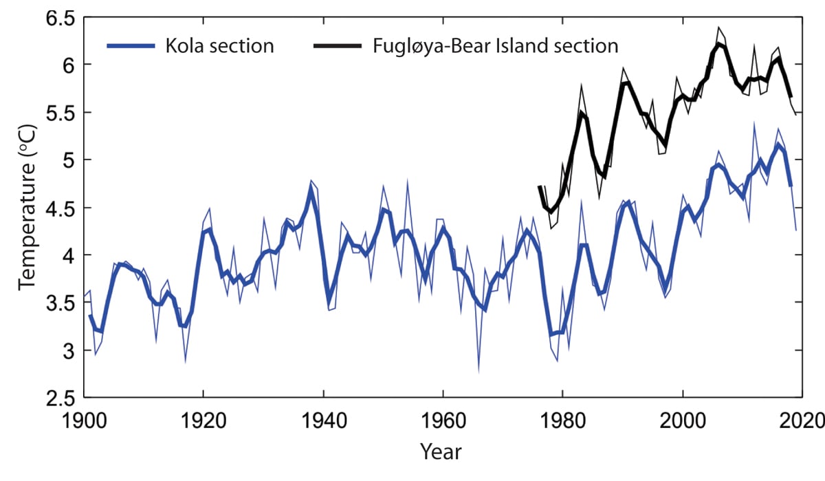
Figure 3.1 Temperature changes in the Barents Sea from 1900 to 2019. Temperature in the centre of the Atlantic inflow, depth 50–200 m for the Fugløya–Bear Island section (black), and depth 0–200 m for the Kola section (blue). Annual values are shown as thin lines and the three-year rolling mean as thick lines.
Source Institute of Marine Research and Russian Federal Research Institute of Fisheries and Oceanography (PINRO)
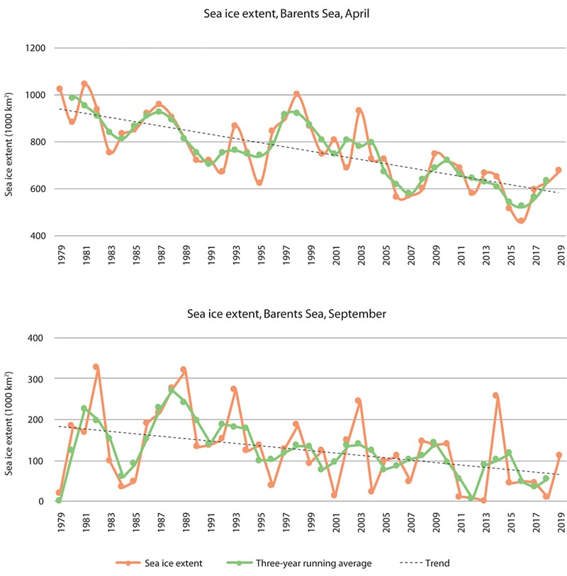
Figure 3.2 Trends in sea ice extent in the Barents Sea in April (upper panel) and September (lower panel) in the period 1979–2019. The data are shown as monthly means for each year (green line), three-year running averages (orange line) and the linear trend for the whole period (black dotted line). There are large interannual variations, but also a clear negative trend through the period.
Source Norwegian Polar Institute/Environmental monitoring of Svalbard and Jan Mayen (MOSJ)
Changes in the distribution of various species have resulted in structural changes in food webs (which represent feeding relationships between species in an ecosystem). The cod stock has been at a high level for the last 10 years, and its changing distribution has been particularly important for both the ecosystem and the fisheries. With rising temperatures and the declining extent of sea ice, cod have spread all the way to the northern and eastern boundaries of the Barents Sea in certain years recently. This has increased predation pressure on polar cod and other Arctic species in these areas. As a result, the Arctic fish species are now largely confined to a small area in the far north of the Barents Sea (Figure 3.4). A number of southerly species of benthic invertebrates and jellyfish have also been registered further north and east in the Barents Sea.
The Barents Sea ecosystem is naturally dynamic, and one consequence of this has been that the capelin stock, which is a key ecosystem component, has collapsed several times (Figure 3.3). Other important trends are the decline of a number of seabird populations, the growth of certain populations of marine mammals that have been protected for many years, and the spread of snow crabs into the Barents Sea.
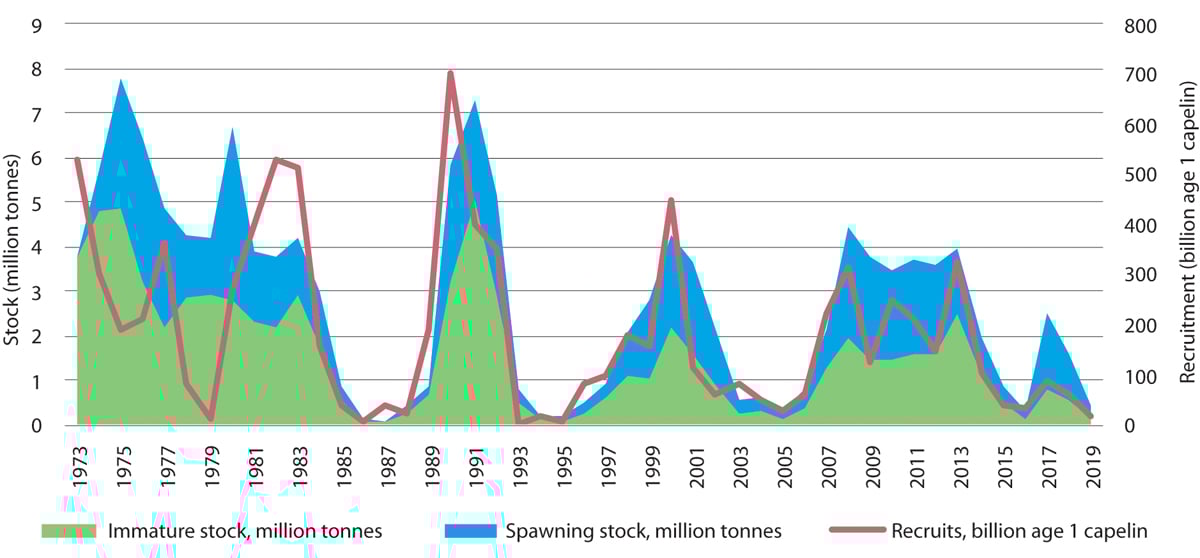
Figure 3.3 Estimated size of and recruitment to the Barents Sea capelin stock.
Source Institute of Marine Research
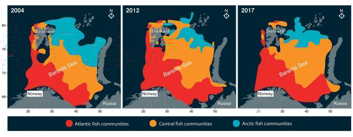
Figure 3.4 Changes in the distribution of Atlantic, central and Arctic fish communities in the Barents Sea from 2004 to 2017. The axes show longitude and latitude.
Source Institute of Marine Research
Rising temperatures and shrinking sea ice cover have also resulted in changes in production and biomass in the ecosystem. Total primary production (phytoplankton) has risen, and biomass in the pelagic part of the ecosystem has almost doubled, mainly as a result of the increasing biomass of Arctic krill species (zooplankton) (Figure 3.5). Growing numbers of southerly krill species have also been observed, and a decline in the quantity of lipid-rich Arctic zooplankton species. This is expected to have impacts on Arctic predators such as the polar cod.
The decline in sea ice has also had direct negative impacts on ice-associated species, for example ringed seal, polar bear and a number of other species groups that live in and on the ice, including ice algae, crustaceans and polar cod. As the area of suitable habitat available to many of these species declines, they may disappear from larger and larger areas of the Arctic. The Barents Sea is one of the areas where this is expected to happen most quickly, because of the rapid loss of sea ice in both summer and winter.
There may also be adverse impacts on benthic animals. When sea ice is present, ice algae attached to the underside of the ice contribute a share of primary production. When the ice melts in spring, much of this biomass sinks to the seabed, where it provides food for the benthic fauna. In an area that no longer has seasonal ice cover, the main primary producers are the phytoplankton, which are to a greater extent food for organisms in the water column, such as zooplankton, and thus form the basis of a pelagic food chain. A decline in the quantity of nutrients sinking to the seabed is therefore expected as the sea ice cover shrinks. As the ice becomes thinner, algal blooms are occurring even under the ice cover, which may compensate to some extent for the reduction in the biomass of ice algae.
Climate models indicate that there will be a continued rise in temperature and loss of sea ice in the years ahead. The changes are expected to be smallest up to the 1930s and accelerate up to 2060. Several models predict very limited amounts of sea ice in the Barents Sea by 2100. For this time horizon, the climate models also indicate that trends in greenhouse gas emissions will be of crucial importance for sea ice cover and thus for the impacts on species associated with sea ice.
Ocean acidification
Ocean acidification has been included in the Barents Sea monitoring programme since 2010. At present, only physico-chemical parameters are monitored, as is the case for the other management plan areas, but work is in progress to establish monitoring of biological effects in addition. So far, monitoring of acidity (pH) and dissolved CO2 in the Barents Sea has not confirmed that the CO2 content is rising, as has been observed in the Norwegian Sea. Because ocean chemistry is naturally very variable in the Barents Sea, longer time series will be needed to reveal acidification than in many other marine areas.
Since no changes in the level of dissolved CO2 have been observed, there are no documented ecological effects of acidification in the Barents Sea. The response to acidification is expected to differ greatly between species. In the long term, species that are tolerant to or benefit from increasing acidification will dominate, which may result in changes in species composition in the ecosystem. This in turn may have implications for ecosystem functioning.
Recent modelling suggests that ocean acidification will increase and there will be a steady decline in pH during this century. The estimated changes in acidity in the Nordic seas and the Arctic up to 2065 involve abrupt changes in pH level, in contrast to a stable pH level for many millions of years before that. The largest changes are expected in the Barents Sea, in the waters around Svalbard and in the Arctic Ocean.
Adult fish are expected to be resilient to ocean acidification, whereas reproduction and early life stages, for example cod and herring larvae, are potentially more sensitive.
Because of responses vary between species, ocean acidification may have impacts both on interspecific competition and on the relationships between different trophic levels in food chains. Such changes may cause ecological cascades throughout the system.
Other anthropogenic pressures acting together with acidification may also have implications for impacts on species and changes in ecosystems. This makes it important to consider the combined effects of ocean acidification and other pressures, for example rising temperatures.
3.1.2 Trends in various components of the Barents Sea-Lofoten ecosystem
Ecosystem trends in the Barents Sea–Lofoten area are described, mainly on the basis of state and pressure indicators for the area.
Plankton and sea ice biota
The rising temperatures and shrinking sea ice cover have resulted in changes in ecosystem production and biomass. Overall primary production has risen, and biomass in the pelagic part of the ecosystem has almost doubled, mainly as a result of rising quantities of krill. There have also been observations of growing numbers of southerly krill species. Considerable reductions in quantities of Arctic mesoplankton have been recorded since about 2004 in an area in the southwesterly Barents Sea where this parameter is monitored. Quantities of the Arctic amphipod Themisto libellula, which is a key species in the Arctic part of the Barents Sea, have also declined as the inflow of cold Arctic water has decreased.
Changes in the distribution and quantities of Atlantic and Arctic species in the Barents Sea may have wider effects in the ecosystem. Declining quantities of lipid-rich zooplankton species, for instance, are expected to have impacts on Arctic predators, which are highly dependent on lipid-rich prey. For example, Themisto libellula is an important prey species for polar cod.
The loss of sea ice has had direct negative effects on ice-associated fauna such as ice algae, amphipods and other crustaceans. When sea ice is present, ice algae attached to the underside of the ice contribute a share of primary production. When the ice melts in spring, much of this biomass sinks to the seabed, where it provides food for the benthic fauna. In an area that no longer has seasonal ice cover, the main primary producers are the phytoplankton, which are to a greater extent food for pelagic organisms such as the zooplankton. A decline in the quantity of nutrients sinking to the seabed is therefore expected as the sea ice cover shrinks. This may have negative impacts on the benthic fauna.
Fish stocks
In response to climate change, the ecosystem in northern parts of the management plan area, primarily north of the polar front, is undergoing major change. The distribution of northerly species such as cod and haddock has expanded considerably northwards and eastwards. The cod stock is at a high level, and the haddock stock is above the long-term average. Fishing pressure on the cod stock has been reduced.
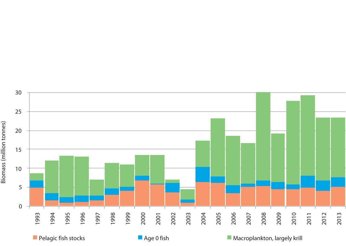
Figure 3.5 Estimated biomass of the pelagic component of the Barents Sea ecosystem from 1993 to 2013.
Source Institute of Marine Research
The golden redfish stock is at a low level because of earlier overfishing, while the beaked redfish stock has shown a positive trend in recent years. The golden redfish stock is still declining, and is now smaller than has ever before been registered. The species is classified as endangered on the 2015 Norwegian Red List, which includes species that are assessed as being at risk of extinction within Norway.
Seabirds
Populations of several of the most abundant seabird species in the Barents Sea have been declining for many years. They include common guillemot and kittiwake along the Norwegian mainland coast and Brünnich’s guillemot and puffin in all or most of the Norwegian part of the Barents Sea. After a population collapse due to a lack of food in winter 1986/87, populations of the three more southerly pelagic auk species – razorbill, puffin and common guillemot – have grown strongly and shown signs of recovery, especially on Bjørnøya. In Finnmark, numbers at the breeding colonies are still much smaller than they used to be. However, the Brünnich’s guillemot population is declining rapidly, and there has been a population decline of between 25 and 50 % since 1990 for Svalbard including Bjørnøya. If this trend continues, it is very probable that the Svalbard population of Brünnich’s guillemot will decline to such a low level that there is no prospect of its recovery in the next 50 years. New results also show that Brünnich’s guillemots in Svalbard stand out as being particularly vulnerable to an abrupt population decline.
Textbox 3.1 Seabird migration patterns – importance of the Barents Sea in autumn
Seabirds from breeding colonies around the Barents Sea and Norwegian Sea are being tracked by the SEATRACK project (http://seatrack.seapop.no/map/), which has shown that the Barents Sea is more important for a number of seabird populations than was previously thought. Puffins are one example – birds from colonies are far south as Runde near Ålesund move to the Barents Sea after the breeding season, as shown on the map below. They remain in the area in the autumn months, August–October, and mix with birds from other colonies in mainland Norway, Svalbard and probably Russia. The Barents Sea is also important for common guillemots, as a foraging and moulting area for birds from populations as far south as the east coast of Scotland and as far west as Jan Mayen. The SEATRACK project tracks seabird movements using light-loggers, or GLS loggers, which are attached to a leg ring with cable-ties. Using this technology over large geographical areas and collecting long time series of data is the most cost-effective method for obtaining information on the importance of Norwegian waters for different seabird species and populations, and how dynamic the patterns of use are over time. Studies using logger technology make an important contribution to more ecosystem-based management of marine ecosystems.
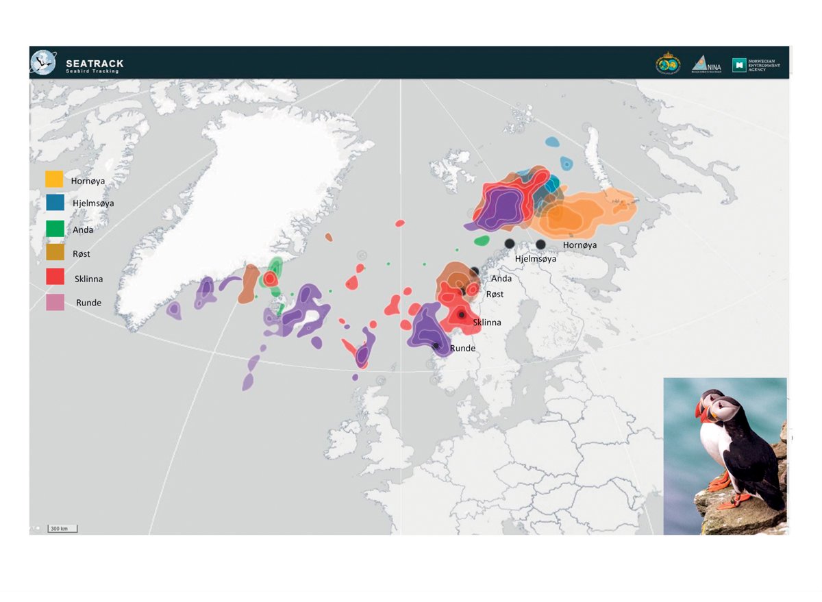
Figure 3.6 Distribution of puffins from six colonies along the mainland coast of Norway in the period August–October 2017, based on tracking data from light-loggers. The Barents Sea is an important moulting and nursery area for several seabird species in autumn.
Source SEATRACK
With the rising sea temperatures, the Arctic food web is being replaced by a more southerly food web. This may be one of the reasons why Arctic seabird species (Brünnich’s guillemot and little auk) are declining, while numbers of more southerly species such as puffin, common guillemot and razorbill are increasing. Food supplies in the breeding season are an important factor, and it has been established that the decline in seabird populations is linked to food shortages. It is difficult to conclude definitely what is causing changes in food supplies, but secondary impacts of climate change and lower production of prey species have been suggested as possible factors. In addition, conditions in wintering areas for seabirds may be important. Harvesting of fish stocks has previously been considered as a possible reason for seabird decline, but is now believed to be of minor importance. Large populations of herring and mackerel may compete for food with seabirds. It is essential to ensure that seabirds, and many other predators in marine ecosystems, have adequate food supplies in the form of small plankton-feeding fish (fish larvae and small schooling fish species) and larger zooplankton such as Arctic krill species. In coastal waters, healthy kelp forests are vital for seabirds and other biodiversity and biological production. A number of seabird species are red listed. The situation of seabird populations was further discussed in the white paper Nature for life (Meld. St. 14 (2015–2016)).
New knowledge obtained through the SEAPOP mapping and monitoring programme for seabirds, including the SEATRACK module for their non-breeding distribution, shows that pelagic species such as the common guillemot, Brünnich’s guillemot, puffin and kittiwake use larger areas when foraging than previously thought, at times up to 100 km out to sea from the breeding colonies.
The seabird mapping and monitoring programme is expected to generate a considerable amount of new information about habitat use by these species outside the breeding season, and provide better data for the breeding season as well.
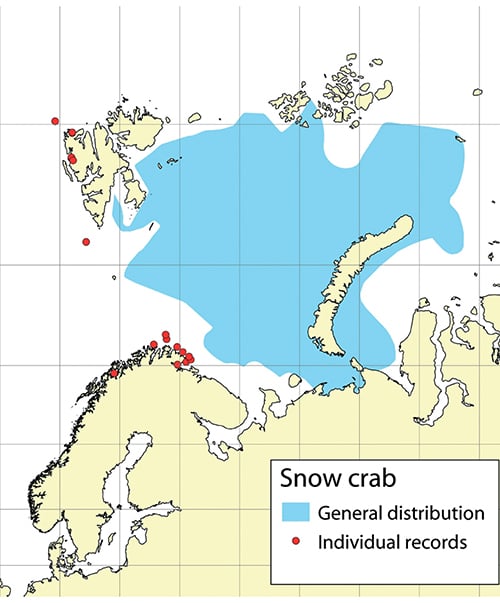
Figure 3.7 Distribution of snow crab in the Barents Sea and individual records outside this area, based on data up to the end of 2019.
Source Institute of Marine Research
Benthic fauna
There has been considerable variability in benthic biomass in different parts of the Barents Sea in recent years. Snow crabs were first registered in the Barents Sea in 1996, near Novaya Zemlya, and the species has been spreading westwards since then. It is likely to become established in much of the northern Barents Sea. The first snow crabs were recorded off the coast of Finnmark in 2005 and off Svalbard in 2011, and they are now widespread in most of the Barents Sea, with the highest densities in its central part. The population has now expanded to all suitable habitat on the Norwegian continental shelf. Numbers could potentially become high, and the snow crab could become an important predator and prey species in the Barents Sea ecosystem. A Russian study has shown that other benthic biomass decreases in areas where snow crab numbers have been high for several years. There has been uncertainty as to whether snow crabs were introduced in the Barents Sea or expanded their range naturally. On the basis of genetic analyses and records of snow crab from several localities between the Barents Sea and the Bering Strait, scientists now believe that snow crabs may have spread naturally westwards from the Bering Strait to the Barents Sea. The distribution of snow crabs is expected to correspond to areas where the temperature of the bottom water is suitable. The snow crab prefers lower water temperatures than for example the red king crab, and its is therefore likely to have a more northerly and easterly distribution. Although snow crabs are most numerous in the open sea, there have been individual records of snow crabs in coastal waters off eastern Finnmark.
The red king crab population is stable, and harvesting is unrestricted west of 26° E, which appears to be effectively limiting the westward spread of the species at present. However, red king crab is being taken as a bycatch in several areas in Troms. It already appears to be breeding in Balsfjorden south of Tromsø. It is uncertain how far south the species will become established. The Norwegian Biodiversity Information Centre has placed the red king crab in the category ‘very high risk’ in its Black List of invasive alien species, because it is considered to have high invasion potential and may have major ecological effects.
The population of cold-water shrimps in the Barents Sea has grown considerably, and is above the long-term average.
As explained earlier in this chapter, a decline in sea ice in an area may have negative impacts on the benthic fauna because inputs of nutrients from ice algae sinking to the seabed are reduced.
Marine mammals
Populations of marine mammals in the Barents Sea are now being influenced both by protection, which has allowed numbers of some species to increase, and by climate change. The walrus population has for example risen after protection, whereas ringed seals are under pressure because they depend on sea ice, and are suffering from habitat loss. The bowhead whale is critically endangered, and for many years was considered to be virtually extinct around Svalbard after overharvesting in the centuries from 1600 to the 1800s. However, recent studies have shown that there are substantial numbers of bowhead whales in the drift ice areas north of Svalbard and in the Fram Strait. Surveys have also shown considerable numbers of narwhals. Both these species are protected, but are highly dependent on the sea ice, and are therefore threatened by climate change. The decline in sea ice cover has also resulted in a steep reduction in the number of polar bear dens in the most important breeding areas.
Populations of the marine mammal species that are harvested are stable or growing. Seal populations along the mainland coast of the Barents Sea are healthy, in contrast to those of coastal seals further south along the Norwegian coast, including the Lofoten Islands. In some top predators, for example polar bears, levels of persistent, bioaccumulative and toxic substances are high enough to have negative effects on health. Animals that are weakened by such contamination may also be more vulnerable to the negative impacts of climate change.
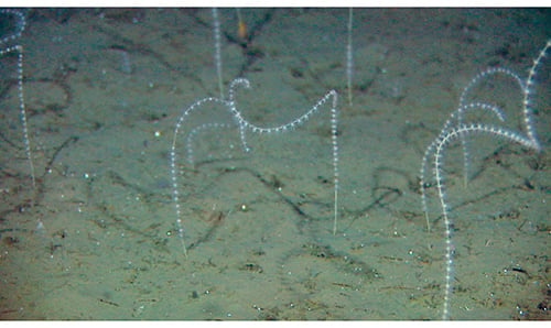
Figure 3.8 Radicipes coral garden, a habitat type classified as endangered in the Norwegian Red List for ecosystems and habitat types 2018.
Source Mareano
Threatened species and habitat types
In all, 26 species found in the Barents Sea–Lofoten area, including the waters around Svalbard, are listed as threatened in the 2015 Norwegian Red List. The conservation status of five species improved from 2010 to 2015 (spiny dogfish, beaked redfish, common eel, Sabine’s gull and mainland populations of common seal), while it worsened for six other species, most of them seabirds (razorbill, common tern, Brünnich’s guillemot, blue whale, ringed seal and the mainland population of fulmar). Two habitat types (Radicipes coral gardens and northern sugar kelp (Saccharina latissima) forests) are classified as endangered in the Norwegian Red List for ecosystems and habitat types 2018, while oarweed (Laminaria digitata) forests are classified as vulnerable. The habitat type Arctic sea ice is classified as critically endangered because of the reduction in the area of multi-year ice.
3.1.3 Pollution
Long-range transport of pollutants with air and ocean currents is the main source of pollution in the management plan area. However, we still know little about the overall transport of pollutants into the area.
Inputs and levels of several of the persistent, bioaccumulative and toxic substances that are monitored in air in Svalbard are still declining. These include heavy metals and certain organic pollutants. Other substances, for example the pesticide hexachlorobenzene (HCB), have shown a weak rise in recent years. There are still high levels of persistent, bioaccumulative and toxic substances in some species at higher trophic levels. Rising temperatures as a result of climate change are expected to increase the spread of such substances worldwide. As the sea ice melts and the permafrost thaws, hazardous substances may be remobilised and evaporate to the atmosphere in the Arctic. Major forest fires and fires on cultivated land have been shown to result in higher inputs of organic pollutants to the Arctic.
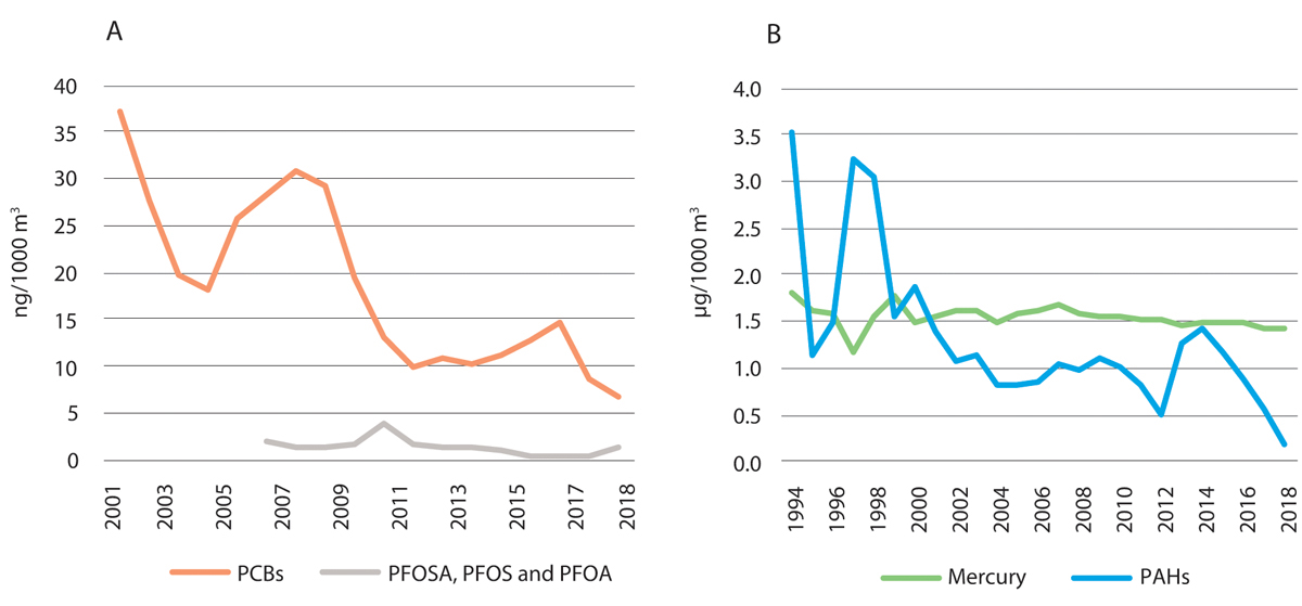
Figure 3.9 Annual mean concentrations of persistent, bioaccumulative and toxic substances in air measured at the Zeppelin observatory, Ny-Ålesund in Svalbard.
Source Norwegian Institute for Air Research, Norwegian Licence for Open Government Data
Inputs of radioactive pollution have declined in recent years, and levels of radioactivity in living organisms are well below the maximum levels set for human consumption. Inputs of nutrients and copper, primarily from aquaculture, are rising along the Norwegian coast, but it is unclear how much of this pollution is transported from coastal waters into the management plan area.
Levels of pollutants in living organisms are stable or declining. The levels are generally low, and well within the limits set for safe seafood. Concentrations of most persistent, bioaccumulative and toxic substances are also below levels that are considered high enough to affect the most vulnerable ecosystem components. The exception is top predators, where high contamination levels are still being registered. However, assessments of effects on the most vulnerable ecosystem components are uncertain because too little is known about the biological effects of such substances, and because new hazardous substances are constantly being detected in Norwegian waters.
Underwater noise
Underwater noise from seismic surveys, sonar and shipping may influence the behaviour of marine mammals. There is further discussion of this in Chapter 3.2 on the Norwegian Sea, which is also relevant to bowhead whale and narwhal north of Svalbard.
3.1.4 Particularly valuable and vulnerable areas in the Barents Sea–Lofoten area
The 2015 white paper on the management plan for the Barents Sea–Lofoten area (Meld. St. 20 (2014–2015)) stated that the need to update the delimitation of three particularly valuable and vulnerable areas – the marginal ice zone, the polar front and the sea areas surrounding Svalbard – would be assessed during revision of the management plan in 2020.
Work on the scientific basis for the management plan included an assessment of whether other areas than those already identified meet the criteria for designation as particularly valuable and vulnerable areas. No new areas were identified, but on the basis of already available knowledge, the delimitation of some areas was altered.
Eggakanten
The Eggakanten area, where there is a steep drop from the continental shelf to the deep waters of the Norwegian Sea, stretches all the way from Stad at about 62° N to the northwestern tip of Svalbard, and oceanographic processes are comparable along its whole length. The particularly valuable and vulnerable area Eggakanten has been extended to include the area around Svalbard, and is now delimited in the same way in the management plans for both the Barents Sea–Lofoten area and the Norwegian Sea. From Stad to Svalbard, it includes the entire continental slope and extends about 10 km on to the continental shelf. Its width varies depending on the steepness of the continental slope. Where the slope is steep, environmental conditions change rapidly, resulting in high diversity over short distances. Delimiting Eggakanten in this way means that about half of the Yermak Plateau northwest of Spitsbergen is included, which is the part of this area where biological activity is highest, down to a depth of about 800 metres (Figure 3.10).
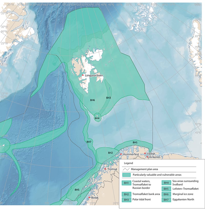
Figure 3.10 Particularly valuable and vulnerable areas in the Barents Sea-Lofoten management plan area.
Source Norwegian Environment Agency
The polar tidal front
There are three frontal zones around the shallow waters of the Spitsbergen Bank and the deeper trench of Hopendypet: a tidal front, a meltwater front and what has traditionally been called the polar front, i.e. the zone where Atlantic water flowing north meets Arctic water flowing south. These frontal zones are different in origin and structure, and therefore also differ in their influence on biological production and activity. The scientific basis for the management plans shows that the tidal front is the zone that is especially valuable and vulnerable. Biological production is high, and the tidal front is an important feeding area for seabirds. The rest of the Spitsbergen Bank area has also been shown to be particularly valuable because production and biodiversity are high and it is an important feeding, nursery and wintering area. The rest of the polar front zone is probably not as important for biological production as previously assumed, and is therefore not identified as a particularly valuable and vulnerable area. The delimitation of the particularly valuable and vulnerable area has therefore been adjusted so that it is restricted to the tidal front, and its name has been changed to the polar tidal front.
The marginal ice zone
Earlier management plans defined the marginal ice zone as a particularly valuable and vulnerable area and showed its extent on maps. It is intended to cover the variable extent of the marginal ice zone, i.e. the area across which it moves during an annual cycle between a maximum in April and a minimum in September. The particularly valuable and vulnerable area thus includes the parts of the marginal ice zone that are most important for the associated biological production and biodiversity.
The boundary of the designated marginal ice zone in the Barents Sea–Lofoten management plan is defined in statistical terms. It follows the line where sea ice has been present on 30 % of the days in April (this is known as 30 % ice persistence), on the basis of a multi-year time series of satellite observations of ice extent. Ice persistence is used as a measure of how likely it is that the marginal ice zone will be in a particular area in a specific month. April is the month chosen because this is when ice cover is normally at a maximum, and it therefore represents the maximum southerly extent of the marginal ice zone over the year. The criterion for determining whether ice is present is an ice concentration exceeding 15 %, meaning that ice covers more than 15 % of the sea surface.
In the 2006 and 2011 white papers on the management plan for the Barents Sea–Lofoten area, the marginal ice zone was delimited on the basis of ice observations from the period 1967–1989. The white paper Update of the integrated management plan for the Barents Sea-Lofoten area including an update of the delimitation of the marginal ice zone (Meld. St. 20 (2014–2015)) presented an update of the delimitation of the marginal ice zone based on ice data for the 30-year period 1985–2014. It also stated that a new update would be presented in the 2020 revision of the management plan for the Barents Sea–Lofoten area. In addition, the white paper announced that the definition used as a basis for determining the delimitation of the marginal ice zone was to be reviewed.
The Forum for Integrated Ocean Management has evaluated the delimitation of the designated marginal ice zone. This is a transitional zone whose value and vulnerability are linked to characteristic features and biological processes, and not just a dividing line between ice and open sea.
In scientific terms, the marginal ice zone is described as the transitional zone between open sea and ice-covered sea, where between 15 and 80 % of the sea surface is covered by ice. This zone is normally only a few tens of kilometres wide. The marginal ice zone is extremely dynamic, and moves from the area around Bjørnøya in the south in spring to north of Spitsbergen early in the autumn. In addition to seasonal variations, it shows more short-term variability, for example as a result of shifts in wind direction and strength.
As the ice melts and retreats northwards during the spring and summer, this creates light conditions and nutrient availability in the marginal ice zone that result in a concentrated bloom of ice algae and phytoplankton. The further north the marginal ice zone is, the larger the share of total primary production from ice algae within the ice or attached to the underside of the. Modelling indicates that most production of phytoplankton takes place within the marginal ice zone and for some distance south of it, and that production drops considerably where the ice concentration exceeds 80 %. From April to September, the productive zone moves northwards through the Barents Sea, and is followed by grazing and feeding plankton, fish, seabirds and marine mammals.
Because the high level of biological production at any time is generally restricted to a zone a few tens of kilometres wide, there may be very high concentrations of grazing species in the marginal ice zone. Together with the importance of the sea ice as a habitat for many species, this makes the marginal ice zone a biologically important and valuable area.
For the commercially important fish species in the Barents Sea, the marginal ice zone is primarily a feeding area, and to some extent a nursery area. Most fish species found in the marginal ice zone in the Barents Sea are strongly associated with the seabed, except for two pelagic species, polar cod and Arctic cod (Arctogadus glacialis).
Seabirds, particularly Brünnich’s guillemots and little auks, can congregate in large numbers in the marginal ice zone and in leads in the ice in spring. Black guillemots and ivory gulls are also common. In addition, fulmars, glaucous gulls and kittiwakes are observed in the marginal ice zone all year round. In late summer, 80–90 % of the world population of ivory gulls is found in the marginal ice zone in the northern Barents Sea. Polar bears occur at higher densities along the outer edge of the marginal ice zone than further north in areas of drift ice.
Several seal species use the ice for whelping, moulting and hauling out, but the importance of the marginal ice zone varies between species and between seasons. The bowhead whale, beluga and narwhal are the only whale species that are adapted to living in areas with ice all year round. In addition, baleen whales (blue, fin, humpback and minke whales) and toothed whales (orcas) feed in the marginal ice zone in the summer months.
A large proportion of biological production in the marginal ice zone sinks through the water column to the seabed, where it provides food for benthic organisms. The marginal ice zone and the northern part of the Barents Sea generally support a large number of benthic species and a high benthic biomass.
One of the most obvious impacts of climate change in the Arctic is the temporal and spatial reduction in sea ice extent. The ice is gradually withdrawing northwards, both in summer and in winter, but there are large interannual variations. The ice cover is also becoming thinner. Because of climate change and the rapid loss of sea ice, the multi-year Arctic sea ice found in the northernmost parts of the marginal ice zone is classified as critically endangered in the Norwegian Red List for ecosystems and habitat types 2018.
According to the Forum for Integrated Ocean Management, more is now known about the ecology of the marginal ice zone, including ecological interactions, species occurrence and vulnerability to different pressures. There are also up-to-date population figures for a number of species and more information about their occurrence in winter; knowledge has been developed about links between seabed, water column and ice (sympagic) communities; and better models are available that include more physical and biological components of the ecosystem.
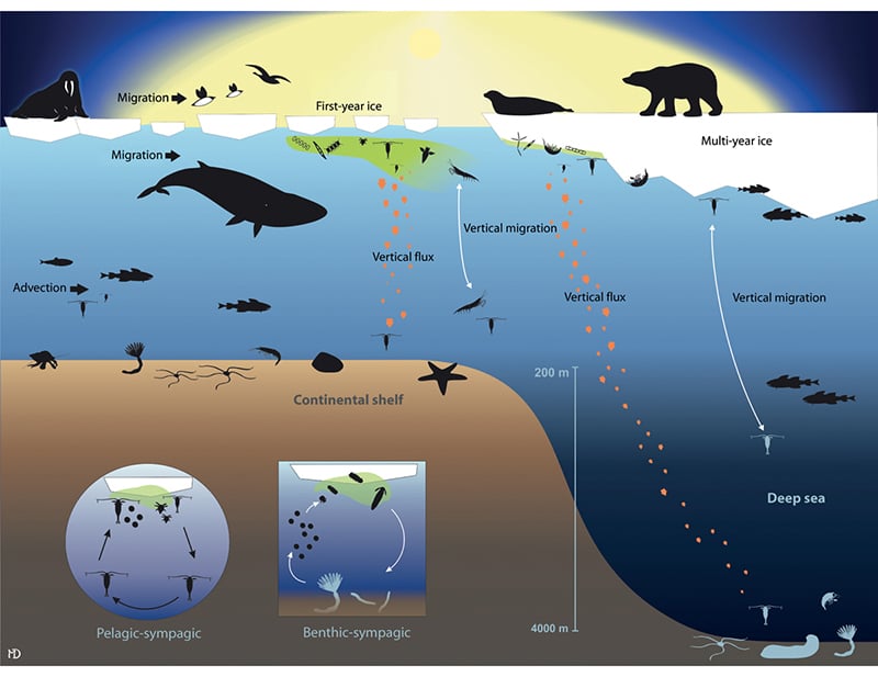
Figure 3.11 Simplified food web in shallow and deeper areas of the marginal ice zone.
Source Norwegian Polar Institute, von Quillfeldt et al. (2018). Miljøverdier og sårbarhet i iskantsonen [Report on environment and vulnerability in the marginal ice zone]
The scientific basis shows that biological production, species occurrence, vulnerability to different pressures and how these vary through the year and between years all influence the value and vulnerability of the marginal ice zone. However, at any time of year, the entire zone is important for a number of species and biological processes.
The Forum for Integrated Ocean Management has evaluated the delimitation of the marginal ice zone. In delimiting this particularly valuable and vulnerable area, it is necessary to take into account the whole extent of the area across which the marginal ice zone moves, including the large interannual variability. The Forum recommended continuing to use the presence of sea ice in April as a basis for delimiting the particularly valuable and vulnerable area, and basing calculations on the most recent time series of satellite observations of ice extent available, which is for the 30-year period 1988–2017. However, the members of the Forum had differing views on what level of ice persistence in April to use: 30 %, as before, or 0.5 %, which would result in the limit being drawn considerably further south.
On the basis of the Forum’s recommendations, the Government has decided to use the line where ice is found on 15 % of the days in April (15 % ice persistence) to delimit the marginal ice zone, based on satellite observations of sea ice extent for the 30-year period 1988–2017. The boundary can be updated using new ice data when the management plans are updated in future.
The marginal ice zone in the Barents Sea, identified and delimited as described above, extends into the northern and western parts of the Norwegian Sea. Two areas here are also designated as two particularly valuable and vulnerable areas – sea ice in the Fram Strait and the West Ice. There is a further account of these areas in the section on particularly valuable and vulnerable areas in the Norwegian Sea, Chapter 3.2.5.
Sea areas surrounding Svalbard
The sea areas surrounding Svalbard have been identified and described as a particularly valuable and vulnerable area in the Barents Sea–Lofoten management plan, but only the area around Bjørnøya has been delimited on maps in the management plan. The 2015 update of the management plan (Meld. St. 20 (2014–2015)) announced the scientific work in the period up to the revision of the management plan in 2020 would include an assessment of how the particularly valuable and vulnerable area around Svalbard can be delimited.
An outcome of this work is a proposal for delimitation of the sea areas surrounding Svalbard as a particularly valuable and vulnerable area. The preliminary delimitation is based on an assessment of the value of the area for biodiversity, but its vulnerability has not yet been assessed. This will be done as part of the review of all the particularly valuable and vulnerable areas being carried out by the Forum for Integrated Ocean Management. This process will also include final delimitation of the area.
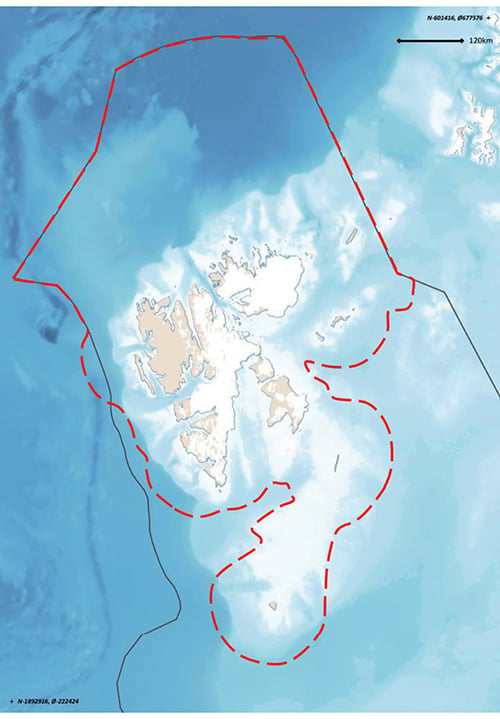
Figure 3.12 Preliminary demarcation of the particularly valuable and vulnerable area sea areas surrounding Svalbard, as proposed by the Forum for Integrated Ocean Management.
Source Norwegian Polar Institute
Three elements are particularly important as a basis for the proposed delimitation of the sea areas surrounding Svalbard: important feeding areas for pelagic seabird species that breed in Svalbard; feeding and breeding areas for marine mammals that are resident year-round near Svalbard; and a range of species and habitats in the Spitsbergen Bank area. In addition, various other valuable species and habitats are to be found within the preliminary demarcation line, boosting the value of the area as a whole. Habitat use and the importance of different parts of the area vary over the year and to some extent from year to year, depending on the location of grazing organisms and the sea ice at any given time.
The Spitsbergen Bank is of crucial importance for the ecosystems in this area. Annual primary production in this area is perhaps higher than anywhere else in the Barents Sea as a result of favourable physical conditions. Much of the primary production from the ice and the water column sinks to the seabed, and the high biomass on the seabed reflects this. A new biotope dominated by the sea cucumber Cucumaria frondosa was registered on the Spitsbergen Bank in 2017.
The waters around Bjørnøya form the southernmost part of this particularly valuable and vulnerable area. The island is a key locality for seabirds, and has some of the largest seabird colonies in the northern hemisphere. The most numerous species are common and Brünnich’s guillemot, little auk, fulmar and glaucous gull. Bjørnøya has the world’s northernmost large breeding colony of common guillemot, which accounts for almost 90 % of the total Norwegian population, and one of the world’s northernmost razorbill colonies. Brünnich’s guillemot and little auk are Arctic species, and the southernmost breeding colonies in the Barents Sea region are on Bjørnøya. It is estimated that more than one million seabirds use Bjørnøya during the breeding season. One reason for this is the rich food supplies in the surrounding waters.
The Vestfjorden
The Vestfjorden, between the Lofoten Islands and mainland Norway, has historically been one of the main spawning areas for Northeast Arctic cod. For most of the period 1970–2000, the Vestfjorden, including the fjord arms Ofotfjorden and Tysfjorden, was also the main overwintering area for Norwegian spring-spawning herring. Although its importance for herring has declined in recent years, the Vestfjorden is potentially a very important area for two of Norway’s major fish stocks. Geographically, most of this area lies in the Barents Sea–Lofoten management plan area, not in the Norwegian Sea management plan area. The description of Lofoten–Tromsøflaket below also applies to the Vestfjorden.
Tromsøflaket bank area
The Tromsøflaket is a shallow area at the entrance to the Barents Sea proper, and supports high biodiversity. The current systems are strongly influenced by the topography of the seabed, which creates eddies, so that the water masses have a relatively long residence time over the Tromsøflaket. The bank area is on the edge of the continental shelf. The eddies also result in longer retention times for fish larvae, for example herring, cod and haddock, and other organisms that drift more or less passively with the water masses, and also for non-living material. This also means that they may be exposed to negative pressures for longer periods. The northern part of the Tromsøflaket is also an important spawning ground for spotted wolffish. There are large and important sponge communities. This area also includes Lopphavet, where there are deep trenches and large coral communities that provide nursery areas for several fish species.
This is an important breeding and wintering area for seabirds, and includes two of Norway’s largest puffin colonies. Total estimates indicate that the puffin colonies in this area have not declined to the same extent as those further south. The relative importance of these colonies is increasing since they comprise a growing share of the Norwegian puffin population. There are two kittiwake colonies where numbers are stable, in contrast to the situation for most other Norwegian kittiwake colonies.
Coastal waters, Tromsøflaket to the Russian border
The coastal waters in this area are a productive environment with high biodiversity. There are rich fish resources, and this is a spawning ground for capelin, a key species in the ecosystem. There are large numbers of seabirds, particularly in the breeding season. Seabirds can forage up to 100 kilometres beyond the baseline. The inner part of the Varangerfjord is an important wintering area for Steller’s eider, common eider, king eider and long-tailed duck. Steller’s eider is the rarest diving duck in the world, and 5–10 % of the entire world population winters in the fjord. These coastal wates are also a moulting area for Norwegian and Russian populations of common eider, king eider and other sea diving ducks. Marine mammals use the whole area, and there are coral reefs in the western and southern parts. Various seabirds that are declining further south have positive population trends in this area, with the exception of kittiwakes, which are showing a very negative population trend. Both common guillemots and puffins breeding along the mainland coast are vulnerable to disturbance from the growing population of white-tailed eagles. Harvesting of red king crab has been unrestricted in this area in recent years, and observations show that the species only occurs in minimal numbers more than ten nautical miles from land. Large areas of kelp forest (Laminaria hyperborea and sugar kelp) along the coast of North Norway have been overgrazed by sea urchins. These habitat types have now been red listed in response to the declining area of kelp forests.
Lofoten–Tromsøflaket
This area has a wide variety of marine habitat types and marine landscapes, and provides a combination of important breeding, spawning, nursery and wintering areas for commercially important fish species, marine mammals and seabirds. It is the most important spawning area for Northeast Arctic cod and haddock. The area also includes the Røstrevet reef complex, the world’s largest known reef of the stony coral Lophelia pertusa. The reef complex is 35 km long and 3 km wide. The continental shelf off the Lofoten and Vesterålen Islands is very rich in nutrients, and plankton production is high. There is a rich fauna in the shallow areas. There are 330 small, intact coral reefs, some of them up to 40 m in height, in an area called Hola.
There are large breeding colonies of seabirds including common guillemot and puffin on the islands of Røst, Værøy and Bleiksøy. Islands and skerries in the Røst area are also an important breeding area for coastal seabirds including black guillemot, common eider and shag, and an important migration and wintering area for a large share of the world population of yellow-billed diver. Geese are making increasing use of the area for staging during the spring migration. Marine mammals such as grey seals, common seals, orcas and sperm whales are also found in the area.
3.2 Environmental status in the Norwegian Sea management plan area
The state of the environment in the Norwegian Sea is generally good, although with a few exceptions. The main trends observed since the mid-1990s are rising water temperature and an increase in the total quantity of pelagic fish species, together with a decline in the quantity of zooplankton. We know little about how or whether these changes are connected. Salinity in the upper water layers of the Norwegian Sea dropped sharply in 2017 and 2018, and the water is now fresher than at any time since 1980. This may be because inflowing water from both the Atlantic Ocean and the Iceland Sea has become fresher. Sea ice extent is declining in the Fram Strait in the northern part of the Norwegian Sea. The Norwegian Sea water has become more acidic throughout the water column, and pH appears to have declined more rapidly in parts of the Norwegian Sea than globally. This may have consequences for marine organisms that have calcium-based shells or skeletons. Ocean acidification will continue for many years, and it is vital to monitor how rapidly it proceeds. The long-term effects on ecosystems are uncertain.
The state of the environment in the Norwegian Sea was discussed in depth in the 2017 white paper containing an update of the management plan (Meld. St. 35 (2016–2017)). In this chapter, the main emphasis is on new information included in the status report published by the Advisory Group on Monitoring in 2019.
3.2.1 Oceanic climate change in the management plan area
The Norwegian Sea climate, described in terms of the distribution of water masses, is largely determined by the properties of the two main currents linking the Atlantic Ocean and the Arctic Ocean – the Norwegian Atlantic current, which transports relatively warm and saline water northwards in the eastern part of the Norwegian Sea, and the East Greenland current, which carries relatively cold, fresh water southwards in the western part of the Norwegian Sea.
Temperature and sea ice
The temperature time series for the Norwegian Sea show that temperatures were variable in the period 1951–2000, but have been consistently higher since 2000. As in the other management plan areas, this warming can be linked to natural changes in the large-scale circulation in the Atlantic Ocean, combined with global warming.
In the northernmost part of the Norwegian Sea, the Fram Strait between Svalbard and Greenland, there are large interannual variations in the extent of the sea ice. However, it has shown a downward trend in both April and September in the period 1979–2017. Higher sea and air temperatures reduce sea ice extent. Since satellite measurements of sea ice extent began in 1979, a downward trend has been observed in much of the Arctic. In the Fram Strait, the ice cover is also strongly influenced by processes in the Arctic Ocean. The ice is becoming thinner, and there are indications that ice export from the Arctic Ocean through the Fram Strait is increasing because the ice is flowing more rapidly through the area than before.
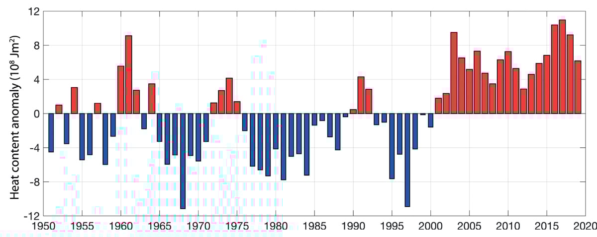
Figure 3.13 Time series for temperature, measured as the heat content of the Atlantic water south of the Arctic front in the Norwegian Sea, for the period 1951–2017, presented as anomalies relative to the long-term average.
Source Institute of Marine Research
Ocean acidification
Studies of inorganic carbon data over a period of more than 30 years show that the seawater in central parts of the Norwegian Sea is becoming more acidic and that calcium saturation levels are declining throughout the water column. Observations show that pH is declining more rapidly in parts of the Norwegian Sea than globally.
Ocean acidification has consequences for marine organisms that have calcium-based shells or skeletons. They will have difficulty in growing and surviving in areas where the seawater becomes too acidic, since it then dissolves calcium carbonate. Marine organisms that will be at risk in Norwegian waters include cold-water corals, which grow along much of the Norwegian coast, and the sea snail Limacina helicina, whose range includes the Norwegian Sea. Limacina helicina is an important prey species for organisms including fish and seabirds. Ocean acidification can also have direct effects on fish larvae and small copepods.
Ocean acidification will continue for many years even if CO2 emissions are reduced. It is vital to monitor how rapidly acidification proceeds and where the changes are greatest. Ocean acidification is influenced directly and/or indirectly by changes in temperature, salinity and biological activity, and there are large natural seasonal variations. Long time series are of crucial importance for an understanding of ocean acidification and its impacts in different areas.
3.2.2 Trends for various components of the Norwegian Sea ecosystem
Ecosystem trends in the Norwegian Sea are described, mainly on the basis of state and pressure indicators for the management plan area.
Kelp forests
Laminaria hyperborea kelp forests are important habitats and nursery areas for fish and other species. In North Norway (along the coast of the Norwegian and Barents Seas), large areas of kelp forest have been overgrazed by sea urchins over the past 40–50 years. In the last 20 or so years, gradual re-establishment of kelp forests has been taking place in the southern part of this region (Trøndelag county and parts of Nordland). This is probably explained by poorer recruitment of sea urchins in warmer water. Re-establishment of both Laminaria hyperborea and sugar kelp is expected to continue further northwards in the years ahead.
Northerly sugar kelp forests (in the Norwegian and Barents Seas) are classified as endangered on the 2018 Norwegian Red List for ecosystems and habitat types. Even though large areas of kelp forest have regrown, it is estimated that more than 50 % of the area of sugar kelp forest in North Norway has been lost. Northern Laminaria hyperborea forest is classified as near-threatened on the Red List. This species has been less affected by overgrazing, and kelp stands in the most exposed areas have never been overgrazed. Nevertheless, it is estimated that more than 20 % of Laminaria hyperborea tangle forest has been lost.
Textbox 3.2 Ecological interactions in kelp forests – juvenile saithe and shags
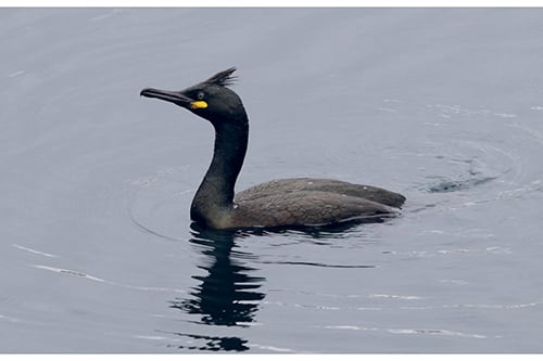
Figure 3.14 Shag.
Photo: Svein-Håkon Lorentsen
Kelp forests along the Norwegian coast are important nursery areas for the youngest year classes of saithe up to about three years of age, when they recruit to the mature pelagic stock. Studies of shags fitted with GPS loggers have shown that they feed largely in the kelp forests, and that a large proportion of their diet is saithe of the youngest year classes (0- and 1-year-olds). Coastal surveys of saithe spawning grounds do not provide adequate data for estimating numbers of one- and two-year old saithe. As a result, there is a lack of good data at an early stage on recruitment to the spawning stock of saithe stock. Recent studies show that the proportion of one-year-old saithe in the diet of shags around Sklinna in Trøndelag is strongly related to the indices for recruitment of three-year-old saithe to the pelagic stock (estimated two years later), for which reliable data is available. This approach could make it possible to estimate recruitment to the pelagic saithe stock two years earlier than at present, providing a better basis for setting a total allowable catch for saithe.
Phyto- and zooplankton
Quantities of phytoplankton in the oceans are determined by currents, light conditions, water temperature, inputs of nutrients and grazing by organisms higher up the food chain. At present, it is difficult to draw any firm conclusions about changes in quantities, species composition or the timing of spring blooms of phytoplankton in the Norwegian Sea, because data are only available for a fairly small number of years and measurements have been made at varying times of year. Satellite data could potentially provide better information on phytoplankton quantities in the surface waters of the Norwegian Sea.
Zooplankton graze on phytoplankton and are important for all higher trophic levels in the food web, including carnivorous zooplankton, fish, marine mammals and seabirds. In the Norwegian Sea, the zooplankton provide food for the main pelagic fish species (herring, mackerel and blue whiting), for fish fry and larvae, and for a number of other fish species, including cod.
Zooplankton biomass in spring (measured in May) has been declining since just after 2000, but there are indications that it is now increasing again. In 2018, zooplankton biomass reached the average level for the time series as a whole. A steep reduction in the biomass of two important subarctic zooplankton species has been observed, but the wider ecological implications of this are unknown.
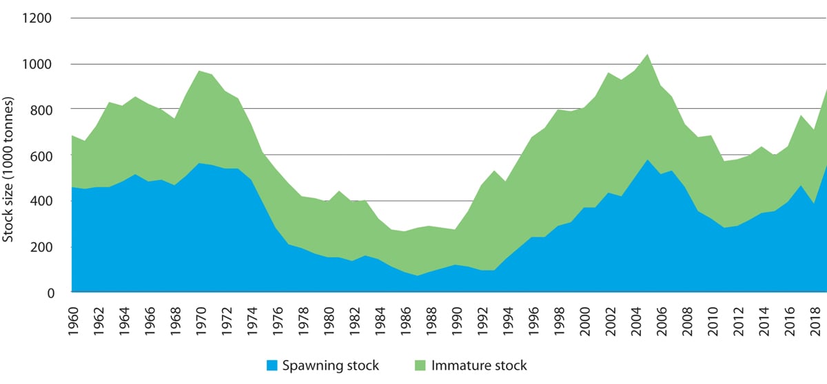
Figure 3.15 Time series showing estimated biomass of the immature stock and spawning stock of Northeast Arctic saithe in the Barents Sea and Norwegian Sea.
Source Institute of Marine Research
Southerly, or warm-water, species in the Norwegian Sea are species that are common in the North Sea or further south, but were previously not normally found in the Norwegian Sea. There has been a sharp increase in their biomass since 2006, and species that have been observed include several copepod species and a species of pelagic sea snail. The largest biomass of southerly species registered so far was in 2011. These are indicator species; their occurrence reflects changes in the physical, chemical or biological environment and indicates biogeographical changes or shifts, for example in response to climate change.
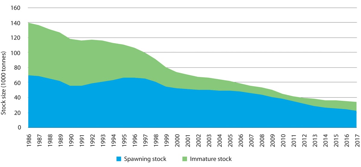
Figure 3.16 Time series showing estimated biomass of the immature stock and spawning stock of golden redfish in the Barents Sea and Norwegian Sea. The sum of the two gives the total stock size.
Source Institute of Marine Research
Fish stocks
The three major pelagic fish stocks in the Norwegian Sea are Norwegian spring-spawning herring, mackerel and blue whiting. The total biomass of these stocks rose considerably from 1995 to 2005, and has since remained at a relatively high level. Even though analyses show clearly that pelagic fish species compete for food, we still do not know whether the rise in pelagic fish biomass since 1995 is the cause of the decline in zooplankton biomass since 2000.
Textbox 3.3 Sandeels along the Norwegian coast
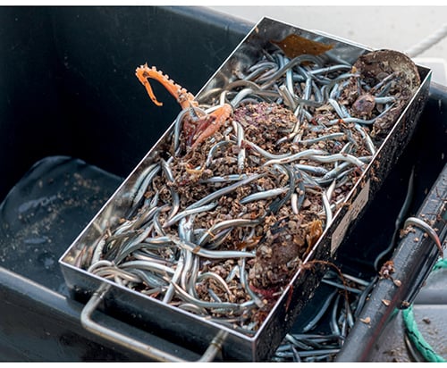
Figure 3.17 Sampling sandeels near Runde island.
Photo: Arild Hareide, Runde Environmental Centre
Small schooling fish species play a key role in marine ecosystems, linking zooplankton with top predators such as seabirds. In Norwegian waters, species such as sprat, herring, capelin and sandeels are particularly important components of the food web. Sandeel is a generic term for a group of small eel-like fish in the family Ammodytidae. Lesser sandeel and small sandeel are found all along the Norwegian coast, while great sandeel is commonest in the south. These species are found in large schools and are highly dependent on specific sandy substrates, where they spend much of the year burrowing in the sand.
Regular monitoring of the diet of breeding seabirds shows that sandeels are among the two or three most important prey types for the typical colony-breeding seabirds, and form a considerable proportion of the diet of kittiwake, common guillemot, razorbill and puffin chicks in many areas.
Little is known about sandeel stocks and their dynamics near the large seabird colonies. The availability of sandeels for breeding seabirds is probably determined mainly by natural variability in recruitment and the distance from colonies to local sandeel populations. We do not know how important local recruitment is for local stocks of sandeels, but studies have not shown genetic differences between lesser sandeels near the coast and further out in the North Sea. Local recruitment probably dominates, but in certain years there is larval drift from the North Sea stocks to coastal waters.
Since 2016, scientists have been mapping sandeel habitat and collecting biological data on sandeels around Runde island. In summer 2019, unusually large stocks of sandeels were registered along the coast from Rogaland and northwards to Hitra west of Trondheim. Sandeels formed a major part of the diet of breeding seabirds on Runde, and fishermen reported catching cod, saithe, haddock and mackerel with their stomachs full of sandeels. There had not been observations of such large quantities of sandeels since the 1960s. There were also sporadic reports of high quantities of sandeels from North Norway, but they did not account for a larger proportion of the diet of seabirds than normal.
The spawning stock of Norwegian spring-spawning herring reached a peak in 2009, but has declined since then. In 2018, the spawning stock was estimated at 3.8 million tonnes, which is above the precautionary level. Recruitment of young year classes to the spawning stock has been weak for many years.
In recent years, mackerel distribution in the Norwegian Sea has expanded. Studies have been carried out to investigate whether this can be explained by rising temperatures. The results show that the expansion in distribution is primarily due to growth of the mackerel stock and not to higher temperatures.
The blue whiting stock in the Norwegian Sea increased and its distribution expanded up to 2003, but this was followed by a sharp decline. The trend reversed in 2011, and the stock grew until 2016, when it began to decline again. In addition, recruitment was low in 2017 and 2018.
The Northeast Arctic saithe stock was at a historically high level from 2001 to 2007, but then declined steeply up to 2011. Since then, it has risen again.
The beaked redfish stock has shown a positive trend. Recruitment to the spawning stock was weak from 1996 to 2004, but has been markedly stronger since then.
The golden redfish stock is now at the lowest level ever recorded, and recruitment has been low ever since the late 1990s. The stock is still declining. According to the International Council for the Exploration of the Sea (ICES), the stock has reduced reproductive capacity and is at a historically low level. Given the low reproduction rate, it is expected that the golden redfish stock will continue to be weak for many years. The species is classified as endangered on the 2015 Norwegian Red List. Other red-listed fish species are blue skate, basking shark, blue ling and spiny dogfish.
Seabirds
There have been dramatic declines in the populations of many seabirds in the Norwegian Sea since the early 1980s, when most monitoring programmes began; numbers of common guillemot (critically endangered) have dropped by 99 %, kittiwake (endangered) numbers at some colonies have declined by more than 90 %, and puffin (vulnerable) numbers have declined by 71 % in this period.
On the other hand, gannet numbers have risen sharply in the same period. The gannet population in Norway now numbers about 6000 pairs (5000 pairs around the Norwegian Sea), and is rising. One important reason for this success is thought to be that gannets feed on larger fish such as herring and mackerel.
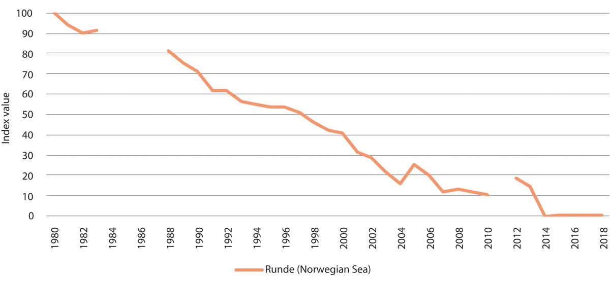
Figure 3.18 Population trend for kittiwakes on Runde island in the Norwegian Sea. Population expressed as index values. Breaks in the graph represent years where no data is available.
Source Norwegian Institute for Nature Research/environment.no
In this same period, the common eider population has declined by about 5 % per year in the areas between Møre og Romsdal county and Røst at the southern end of the Lofoten Islands that are included in the monitoring programme. This decline is worrying, especially because little is known about the causes.
Understanding of the changes that have been observed is limited, but climate change and changes in food supplies (zooplankton and small fish of pelagic and demersal species such as herring, sandeels and gadids) may be important. The Norwegian spring-spawning herring stock has not produced a strong larval year-class since 2004, and this has had a serious effect on the breeding success of Norwegian populations of pelagic seabirds. It is not known whether the growth of the mackerel stock in the Norwegian Sea has affected recruitment to fish stocks that are important in the diet of seabirds. Both common guillemots and kittiwakes, which nest on open ledges, are also vulnerable to predation and disturbance by raptors, particularly white-tailed eagles.
Pelagic seabird species such as common guillemot, puffin and kittiwake forage in areas up to 100 km out to sea from the breeding colonies on Jan Mayen and in mainland Norway.
Marine mammals
The hooded seal population is at the lowest level ever recorded. Modelling of the Northeast Atlantic population since 1945 shows a dramatic decline from about 1.3 million animals to about 200 000 in 1980, and a further decline to an estimated 81 000 animals in 2012. The harp seal population was estimated at about 430 000 in 2018. This is a reduction of 35 % since 2012.
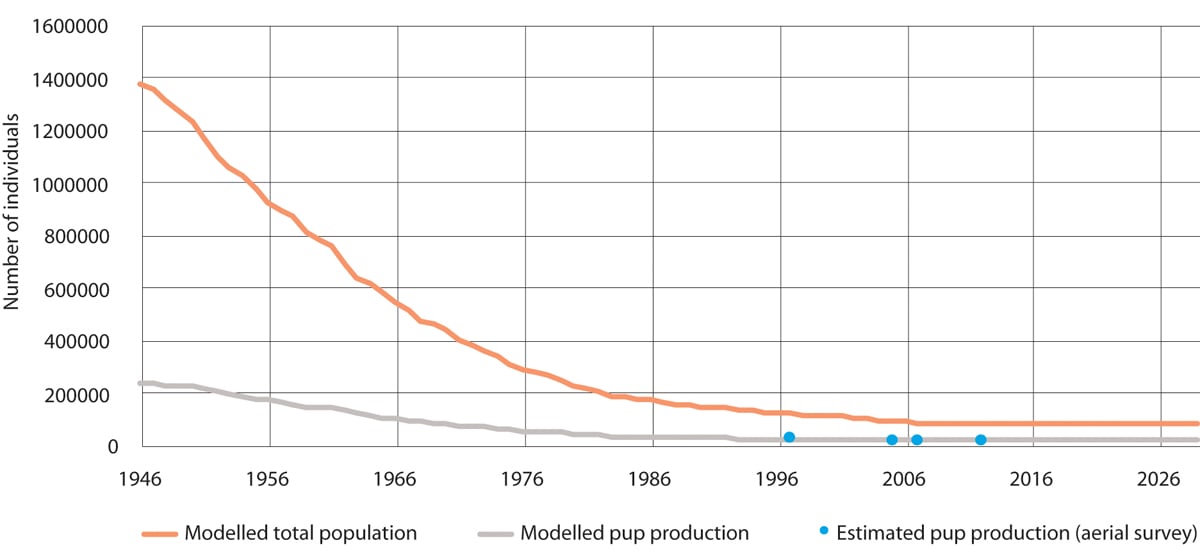
Figure 3.19 Modelled population of hooded seal in the West Ice. The orange line shows the modelled total population, the grey line shows modelled pup production and the blue dots show estimated pup production based on aerial surveys.
Source Institute of Marine Research/Environmental monitoring of Svalbard and Jan Mayen (MOSJ)
The most recent population estimates for the coastal seal species, grey seal and common seal, are those presented in the 2016 status report from the Advisory Group on Monitoring. The ban on hunting these species in parts of Trøndelag, introduced after a sudden population decline in 2015, has therefore been maintained.
New information on how Arctic whale species use the northern part of the Norwegian Sea management plan area has become available, and shows that the narwhal population is stationary.
The porpoise population was surveyed in 2105, and numbers in Norwegian waters north of 62 °N were estimated at 83 700. Porpoises in fjord areas other than Vestfjorden were not included, and it is thought that including these areas could increase the estimate by about 15 %. Recent analyses show that Norwegian gill net fisheries took an average annual bycatch of 3000 porpoises in the period 2006 to 2015. Modelling indicates that there may have been a certain real decline in the porpoise population in this period as a result of the bycatches.
The bowhead whale, hooded seal and otter are all on the 2015 Norwegian Red List of species.
Threatened habitat types
Norway has registered more reefs of the cold-water coral Lophelia pertusa than any other country, most of them in the Norwegian Sea. Because of a reduction in their total area and habitat degradation, coral reefs are categorised as near-threatened in the 2018 Red List for habitat types and ecosystems. Between 30 and 50 % of the registered reefs off the Norwegian coast that have been investigated have some degree of physical damage caused by bottom trawling. In areas where there is major damage, there are also clear effects both on the extent of reef complexes and on the species composition of coral reef communities. However, even less extensive damage has been shown to affect species composition and biological processes.
Hard-bottom coral gardens are dominated by vulnerable, very fragile soft corals (the sea fans Primnoa resedaeformis, Paragorgia arborea and Paramuricea placomus). This habitat type has been classified as near-threatened because the total area has declined and it is under pressure from the fisheries.
In shallower coastal waters, northern kelp forests (Laminaria hyperborea and sugar kelp) are now considered to be endangered and near-threatened respectively, and two habitat types are considered to be vulnerable (oarweed forests and mussel beds that are exposed to wave action). In the Fram Strait there is Arctic sea ice, which is classified as critically endangered in the 2018 Red List because of the reduction in the area of multi-year ice.
Alien species
Climate change and human activities such as shipping may result in the establishment of increasing numbers of alien species in the Norwegian Sea. Climate change may be a reason why species that would not otherwise have survived in the Norwegian Sea are now able to establish populations.
The comb jelly Mnemiopsis leidyi was introduced to Europe from the northeastern coastal waters of the US with ballast water, and has established populations in the North Sea. There is probably not an established reproducing population in the Norwegian Sea at present. However, considerable numbers of M. leydi are from time to time carried into the Norwegian Sea with the Norwegian coastal current. There is considered to be a very high risk that the species will be able to reproduce in the Norwegian Sea.
The Pacific oyster (Crassostrea gigas) has been registered as far north as Eide near Kristiansund. The species became established in Norway by spreading northwards from Sweden and Denmark, although there may be a proportion of individuals originating from earlier oyster cultivation. Two alien bryozoan species, Tricellaria inopinata and Schizoporella japonica, were found at several coastal localities in Møre og Romsdal county in 2017 and 2018. The habitat preferences of these species indicate that they could probably also become established on fixed or anchored installations further out to sea, in the management plan area itself. These examples show that there may be a considerable potential for alien species to spread to the Norwegian Sea management plan area as well.
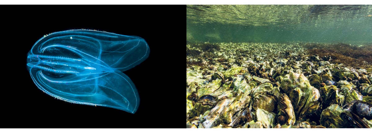
Figure 3.20 Alien species observed in the Norwegian Sea. The comb jelly Mnemiopsis leidyi to the left, and Pacific oysters to the right.
Photos: Erling Svensen (left), Kim Abel, Naturarkivet (right)
3.2.3 Pollution
Inputs of pollutants to the Norwegian Sea are generally stable or declining. Levels of pollutants are generally lower than in certain fjords along the coast and lower than in the North Sea and Skagerrak. However, there is some cause for concern.
Environmental quality standards have been set for a number of pollutants to protect the most vulnerable ecosystem components, and these levels are being exceeded for example for mercury, PCBs and brominated flame retardants (PBDEs) in a number of species. This means that the levels of persistent, bioaccumulative and toxic substances that accumulate in top predators, such as seabirds and marine mammals, may be high enough to have environmental impacts. However, levels of hazardous and radioactive substances are generally below the maximum permitted levels of contamination in seafood in the species that are monitored. The exceptions are fish liver (often contains high levels of organic pollutants), halibut from the Sklinnadjupet trough (high levels of mercury, dioxins and dioxin-like PCBs detected), edible crabs from Saltfjorden near Bodø and northwards (contain high levels of cadmium), and tusk from Vestfjorden (contains high levels of mercury). Marine litter, including micro- and nanoplastics, is present everywhere – on the seabed, in the water column and on the beaches. Little is known about levels of micro- and nanoplastics in seafood.
The pelagic fish species are important seafood resources, and large quantities are harvested in the Norwegian Sea. Hazardous substances are monitored regularly in both herring and mackerel in the Norwegian Sea. The results show that hazardous substances are present in these species, but the levels are not rising and are well below the maximum permitted levels in seafood.
Since 2010, concentrations of hazardous substances in air have been monitored on Andøya (Nordland). Concentrations of lead and cadmium have been more or less unchanged since measurements started and are similar to those measured in Svalbard, but lower than at the Birkenes measuring station in Southern Norway. The Andøya measurements show declining levels of mercury in air, and the same trend is being observed at Birkenes and in Svalbard.
Levels of many organic pollutants are lower at Andøya than in Svalbard. These include the pesticide HCB, PCBs, and brominated flame retardants (PPDEs). Levels of the pesticides HCH and DDT and of perfluorinated substances (PFAS, including PFOA) measured at Andøya are as high as or somewhat higher than levels in Svalbard.
Calculations of annual inputs of pollutants to coastal waters show a general downward trend for lead. Copper inputs showed signs of stabilisation or a weak decline from 2009, but increased again in the period 2013–2017. This rise is mainly explained by the use of copper in impregnation agents for salmon nets by the aquaculture industry. Inputs of nutrients rose steeply in coastal waters for a period starting in the 1990s, largely because of discharges from the aquaculture industry, but concentrations of these substances transported to the coast by rivers have been relatively stable. There has been no substantial increase in nutrient inputs since 2012. However, it is unclear what proportion of all these pollutants is transported from coastal waters into the management plan area.
Discharges of produced water to the Norwegian Sea currently make up 10–20 % of total discharges on the Norwegian continental shelf, and discharges of oil to water are considerably smaller than in the North Sea.
Underwater noise
Underwater noise from seismic surveys, sonar and shipping may influence the behaviour of marine mammals.
Noise from shipping is audible to both fish and marine mammals. It is unlikely that noise from shipping causes direct harm to fish and marine mammals, which has been demonstrated in individual organisms close to intense noise sources such seismic shooting and low-frequency sonar. However, temporary scare effects are to be expected. The scare effects of shipping on certain whale species have been investigated. It has been shown that when minke whales and porpoises come within a radius of about 600 and 1000 m respectively from a ship, they will take avoiding action. Other species, for example white-beaked dolphins, are attracted to boats. Responses to noise thus appear to vary from one species to another. One explanation may be that fish and marine mammals can become habituated to noise sources, even to noise that is intended to deter them. Studies suggest that seals and porpoises can become habituated to pingers attached to fishing gear to keep marine mammals away.
Passive acoustic monitoring (using data buoys) in the northwestern the Norwegian Sea has demonstrated underwater noise more or less all year round in areas that are key habitats for threatened populations of various whale species. These areas are relatively little used, and the results are not representative of the noise picture in the rest of the management plan area. Both bowhead whales and narwhals use the drift ice areas in the Fram Strait all year round, and exhibit intense vocal activity in the winter months (the mating season).
3.2.4 Valuable species and habitats in the deep sea
There are large deep-water areas under Norwegian jurisdiction in the Norwegian Sea, including the northernmost part of the Mid-Atlantic Ridge. This is the geologically most active area in Norway, where there are large underwater mountains and rift valleys, and areas with distinctive environmental conditions and ecosystems and habitat types about which little is known.
Habitats where there are hydrothermal vents and associated deposits of metal sulphides and methane hydrate (natural gas trapped in ice crystals) support very specialised organisms that form distinctive marine ecosystems along the Mid-Atlantic Ridge. There are also hydrothermal vents and associated deposits of methane hydrate along the continental slope, which support similar ecosystems. These ecosystems are based on chemosynthesis, meaning that organisms use chemical compounds in the water as a source of energy, rather than sunlight. Microorganisms are the primary producers in such ecosystems, and are a vital basis for all life in these areas. Hydrothermal vents can be active for thousands of years. When they are no longer active, the ecosystem in the area changes from the distinctive chemosynthetic system to one with a normal benthic fauna. Deposits of manganese crust, which are rich sources of various metals, have also been found in large areas of the Norwegian Sea. The crust is deposited from seawater on bare rock, and contains important chemical elements. There is now a growing research effort and more focus on the management of deep-water areas. Valuable species and habitats in deep sea areas were also discussed in the 2017 update of the Norwegian Sea management plan (Meld. St. 35 (2016–2017)).
Organisms living in extreme deep-sea environments have unique adaptations to enable them to survive in the extreme conditions. Microorganisms and biomolecules can be harvested for industrial and medical uses (marine bioprospecting) from hydrothermal vent fields. Research using cutting-edge DNA sequencing techniques has revealed a wide diversity of microorganisms and a vast, unique genetic reservoir in these ecosystems. Less is known about interactions between seabed ecosystems and those in the water column above, and research will be needed on this in future.
Hydrothermal vents and the formation of mineral deposits
So far, seven active and two inactive hydrothermal vent fields containing metal deposits have been discovered at depths of between 140 and 3100 metres in the Norwegian Sea.
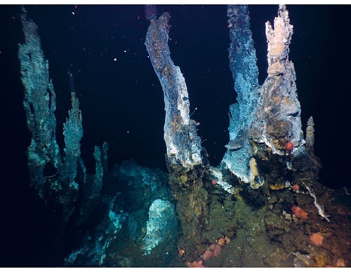
Figure 3.21 These ‘black smokers’ on the Mid-Atlantic Ridge between Jan Mayen and Bjørnøya are hydrothermal vents formed by the deposition of metal-rich sulphide minerals. Such areas support a highly diverse community of organisms closely adapted to the conditions, ranging from single-celled microorganisms to fish.
Photo: University of Bergen
The habitat types in areas around hydrothermal vents are often dominated by sponges and other filter feeders. The extent of our knowledge about the biology of the vent fields varies. On the Seven Sisters field and the Jan Mayen vent fields, surveys have shown dense assemblages of sea anemones and snails feeding on the bacterial mats, carnivorous sponges that live in symbiosis with methane-oxidising bacteria, calcareous sponges, hydroids and large numbers of sea lilies. The three Jan Mayen vent fields are the best surveyed thus far. They are situated about 70 km north-east of Jan Mayen itself. Little is known about the biology of the Ægir vent field, but it has a number of species in common with the Loki’s Castle vent field. The latter was discovered in 2008 and is much better known. It was also the first locality in Norwegian deep-sea areas where scientists found species that are specifically adapted to the high temperatures around hydrothermal vents. There is a wide variety of specialised species, including species that are endemic to the area.
In 2018, the Fåvne vent field was discovered at a depth of 3000 m midway between Jan Mayen and Bjørnøya. Here, highly metal-rich water gushes from a number of vents. The discovery of the Fåvne vent field has given us a greater understanding of the fauna associated with hydrothermal vents. The deep-water fauna on the active vent fields Loki’s Castle, Fåvne and Ægir is of exceptional interest. Species are specially adapted to the environmental conditions, and energy transfer through the ecosystem is driven by close interactions between microorganisms and higher organisms (symbiosis). The fauna is dominated by specialised polychaetes, snails, amphipods and sponges, and shows similarities with the fauna associated with hydrothermal vents near the edge of the Arctic Basin.
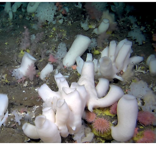
Figure 3.22 The hard-bottom areas around hydrothermal vents are often dominated by sponges and other filter feeders. These areas support high biodiversity and are particular importance for ocean nutrient cycles.
Photo: University of Bergen/SponGES
Methane hydrates
Methane hydrates consist of methane trapped in ice crystals in the seabed, and are only stable at high pressure and low temperature. They are found on the continental shelf and the continental slope in association with natural gas seeps. Methane hydrates can provide a source of energy. There are distinctive geochemical substrates around methane hydrate deposits and cold seeps, which provide a habitat for chemosynthetic bacteria. These bacteria support a distinctive fauna not dissimilar to that found around hydrothermal vents. However, the fauna associated with methane hydrates occurs over larger areas and is quite similar in different localities.
3.2.5 Particularly valuable and vulnerable areas in the Norwegian Sea
The summary report from the Forum for Integrated Ocean Management discusses the previously identified particularly valuable and vulnerable areas, and where the updated scientific basis indicates that modifications are needed. The updated scientific basis confirms the value and vulnerability of the areas for which no modifications were indicated. The delimitation of some particularly valuable and vulnerable areas in the Norwegian Sea has also been clarified and adjusted. The particularly valuable and vulnerable areas and the species and habitat types found in them are further discussed in the Forum’s reports and in earlier white papers on the management plans. This section discusses some updates to our knowledge about the particularly valuable and vulnerable areas in the Norwegian Sea.
The Vestfjorden has been removed from the list of particularly valuable and vulnerable areas in the Norwegian Sea and has been transferred to the list for the Barents Sea–Lofoten management plan area, where most of it lies. The rest largely overlaps with the particularly valuable and vulnerable area coastal waters Norwegian Sea.
In coastal waters Norwegian Sea, sea urchin populations are declining and kelp forests are recovering in the outer zone of coastal waters as far north as the southern part of Nordland county. The coral reefs in the Iverryggen area are considered to be in good condition. The waters between Vikna and the Vega archipelago (a World Heritage Site) and out to the Sklinna bank particularly valuable and vulnerable area are valuable for seabirds. In this area, there are large numbers of wintering and breeding coastal seabirds including common eider, shag, cormorant and black guillemot, and pelagic feeders including common guillemot, puffin and kittiwake. The lesser black-backed gull (subspecies Larus fuscus fuscus) also breeds in the area. This is considered to be more of a pelagic feeder than more southerly subspecies of lesser black-backed gulls.
The Jan Mayen area is nationally important for breeding seabirds. There are 15 breeding species and 22 different seabird colonies, with a total of more than 300 000 pairs of seabirds. The time series for seabird monitoring in this area are relatively short, and some species can show large annual variations. A decline has been registered for the common and Brünnich’s guillemot populations, while the fulmar and glaucous gull populations are stable and great skua numbers have risen. The West Ice north and west of Jan Mayen is a core breeding area for hooded and harp seals. The West Ice population of hooded seals has declined to less than 10 % of the level immediately after the Second World War, and has been protected since 2007. The population decline may be related to the reduction in ice cover.
The marginal ice zone in the Barents Sea, as identified and delimited as a particularly valuable and vulnerable area, extends into the northern and western parts of the Norwegian Sea, which are also ice-covered for part of the year. The areas in question are sea ice in the Fram Strait and the West Ice, which is in the northwestern part of the fisheries zone around Jan Mayen. The delimitation of these areas has been updated in line with the changes in the Barents Sea–Lofoten management plan area, so that their boundaries now follow the line where there is 15 % ice persistence in April, based on ice data for the period 1988–2017. The scientific basis shows that there are no grounds for distinguishing between very important areas closest to Jan Mayen and important areas further out, as was done in the original particularly valuable and vulnerable area ‘Areas near Jan Mayen and the West Ice’. The Forum for Integrated Ocean Management has therefore removed this division.
The area sea ice in the Fram Strait is dominated by sea ice transported southwards from the Arctic Ocean by ocean currents. The ice in the Fram Strait is often a mixture of ice of different origins, and therefore consists of ice types of varying age and with different properties. Ice in the part of the marginal ice zone within the Fram Strait is on average thicker, has more snow cover and lies above deeper water than much of the marginal ice zone in the Barents Sea. Because of the variety of ice types, many different types of ice-associated communities are also found. The marginal ice zone in the Fram Strait is important for ivory gulls and for the critically endangered Spitsbergen population of bowhead whale. The sea ice in the Fram Strait is gradually withdrawing northwards, both in summer and in winter, but there are large interannual variations.
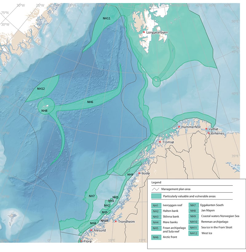
Figure 3.23 Particularly valuable and vulnerable areas in the Norwegian Sea management plan area.
Source Norwegian Environment Agency
The designated Arctic front area covers the zone where Atlantic and Arctic water meet. The area was originally described as a narrow zone stretching all the way through the Norwegian Sea where biological production is high and there is a rich diversity of animal species. As is the case for the polar front, there is so far no documentation that biological production is higher in the frontal zone than in the surrounding waters. However, the frontal zone may nevertheless be important as a habitat boundary for various species, and may be an area where species from different trophic levels aggregate. The Arctic front is an important feeding area for several whale species, including blue whale, fin whale, minke whale and bottlenose whale. The position of the Arctic front also has implications for the migration and distribution of Norwegian spring-spawning herring, which to a large extent avoids Arctic water masses.
The Remman archipelago is designated as a reference area for Laminaria hyperborea, and there is therefore no kelp harvesting in the area. There has been some increase in the vulnerability of seabirds in the area as a result of bycatches in the gill net and longline fisheries.
Coastal waters Norwegian Sea as designated stretches from Stad at 62° N northwards to the Vestfjorden. Many species use waters near the coast as a habitat and feeding area, and the area off the Norwegian Sea coast includes many localities that are important for seabirds. The section of the coastal zone from Stad to Runde, the coast of Sør- and Nord-Trøndelag (including the Froan, Vikna and Sklinna archipelagos) and the southern part of Nordland (including islands and skerries in Sømna and Vega municipalities), the Remman archipelago and the Vestfjorden are considered to be particularly valuable. Marine mammals such as the grey seal, common seal, common porpoise and orca occur all along the coast. Kelp forests are an important habitat for many marine organisms in the coastal zone.
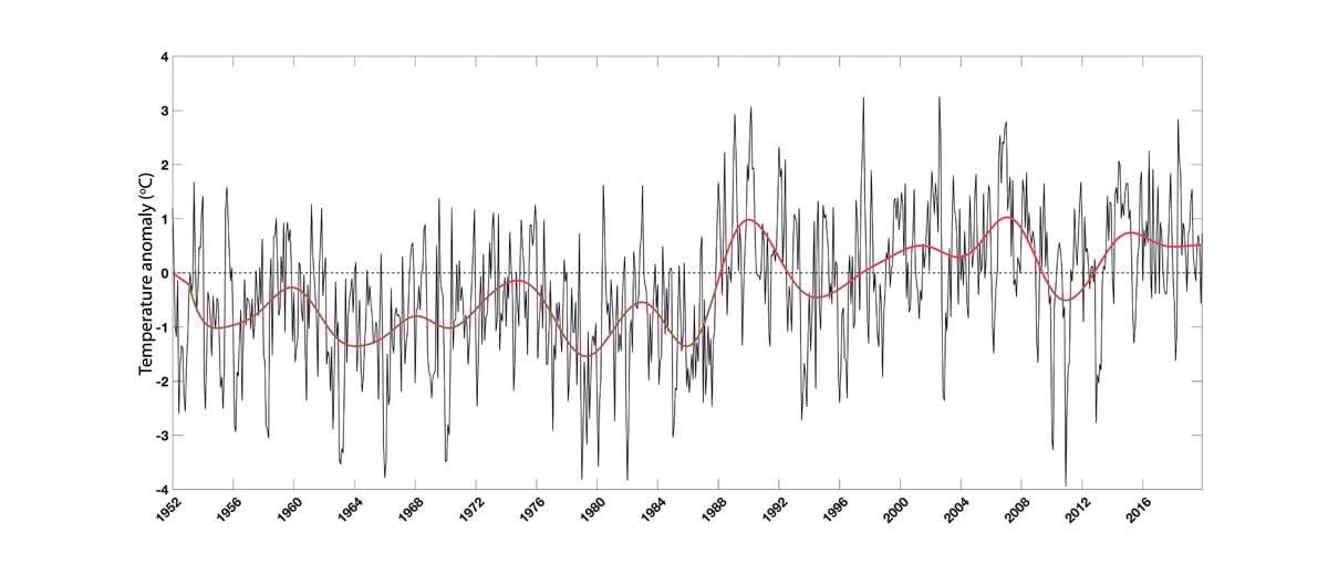
Figure 3.24 Temperature time series from 1952 to 2018 for Norwegian coastal waters in the Skagerrak and the North Sea, presented as anomalies relative to the period 1981–2010. Based on measurements by the Institute of Marine Research along the sections Torungen–Hirtshals and Utsira–Orkney (only measuring stations near the coast) and at the coastal stations Flødevigen, Lista, Utsira and Sognesjøen at depths of 0–10 m. The thin black line shows monthly values with the seasonal signal removed, while the red line shows the five-year rolling mean.
Source Institute of Marine Research
3.3 Environmental status in the North Sea and Skagerrak
The most important trends in the North Sea–Skagerrak ecosystem since 2011 include persistently high sea temperatures and a continuing spread of southerly zooplankton species, which has had substantial impacts on the rest of the ecosystem. Many fish stocks have grown considerably in recent years, while levels of pollutants have generally remained unchanged or declined.
3.3.1 Climate change in the management plan area
The northern North Sea constitutes most of the management plan area. It varies in depth from 0 to 500 m, and is heavily influenced by the inflow of oceanic water from the Norwegian Sea and Atlantic Ocean.
Temperature
Since the late 1980s, a generally rising trend in sea temperatures has been registered in the North Sea and Skagerrak, and temperatures have generally been above the long-term average for the period 1981–2010. Warming has slowed somewhat in the past ten years, but temperatures both in the surface layers and in deep water have remained high for the last 30 years. Although some of the warming can be linked to natural changes in the large-scale circulation in the Atlantic Ocean, most of it is related to the global warming trend.
3.3.2 Trends for various components of the North Sea–Skagerrak ecosystem
Ecosystem trends in the North Sea and Skagerrak are described, mainly on the basis of state and pressure indicators for the area.
Kelp forests
Sugar kelp forests are an important habitat type in Norway’s coastal waters, and are nursery areas and habitats for many marine species. In the Skagerrak and southwestern Norway, sugar kelp forests and eelgrass meadows are under considerable pressure from a number of factors. The decline in the distribution of sugar kelp in the Skagerrak is probably explained by periods in the late 1990s when summer temperatures were very high, which may have been lethal to the species, combined with high inputs of nutrients, which have favoured competing filamentous algae. Increasing runoff from land and inputs of humus and particulate matter can reduce light penetration in coastal water, increase sediment deposition on the seabed and reduce the depths to which kelp can grow. Reduced light penetration has been observed in the Norwegian coastal current over a long period. This may be a result of direct runoff to coastal areas. Monitoring of rivers that run into the Skagerrak shows that they have been transporting increased quantities of dissolved organic matter to the coast. In hard-bottom areas of the Skagerrak, sugar kelp is now found in shallower water than previously.
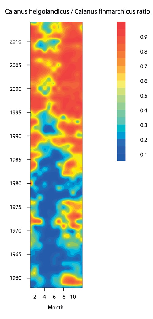
Figure 3.25 Ratio between the warm-water species Calanus helgolandicus and the cold-water species Calanus finmarchicus in the North Sea in the period 1958–2012. The figure shows that in the 1960s, substantial numbers of the warm-water species were only recorded at certain times of year, whereas after 1995 it has been dominant for most of the year.
Source Edwards et al. MCCIP Science Review 2013/ICES
Since 2000, there has been a weak improvement in the state of sugar kelp forests, but over the past 50 years its distribution has declined in the southern half of Norway, particularly in the Skagerrak. Losses were greatest in the Skagerrak around 2000 (50–80 %), but have also been substantial in the North Sea (50 %). Sugar kelp forests in the North Sea and Skagerrak (southern sugar kelp forests) are classified as endangered on the Norwegian Red List for habitat types and ecosystems 2018.
Phyto- and zooplankton
Primary production, or production of phytoplankton, has declined in recent years. This is probably because inputs of nutrients to the entire North Sea from the major European rivers and other land-based sources have been reduced. As a result, the previously serious problem of eutrophication has been largely eliminated.
In the North Sea, quantities of southerly zooplankton species have increased at the expense of zooplankton species that are adapted to colder water. The copepod Calanus finmarchicus is an important zooplankton species in the North Sea. In recent years, it has increasingly been replaced by the warmer-water species Calanus helgolandicus. Other changes have also been registered, and the proportion of other warm-water zooplankton species has been rising. One result of these changes is that the timing of reproduction for zooplankton species has shifted to later in the year.
These changes in the zooplankton community have had a variety of effects on other parts of the North Sea and Skagerrak ecosystems. The shift in the timing of zooplankton reproduction means that it no longer coincides as well with fish spawning seasons, which may have reduced fish food supplies and be one explanation for poor recruitment to several fish stocks. The shift towards warm-water species is also resulting in generally lower zooplankton production, which is expected to have implications for fish stocks generally and particularly for plankton-feeding species.
The increase in the proportion of warm-water zooplankton species may also explain why there has been an increase in observations of southerly fish species that are adapted to feeding on this type of plankton, such as European seabass, anchovy and pilchard. Such species have previously occurred sporadically in the North Sea, but breeding populations are now becoming established. The changes in the North Sea have resulted in an ecosystem that is less productive but has higher species diversity. The pelagic ecosystem in the North Sea is very complex, and knowledge about ecological links between the water column and the seabed is very limited. This makes it extremely difficult to predict what impacts climate change will have on benthic communities in the future.
Benthic fauna
A decline in mussel populations has been registered in recent years. Very little is known about the extent of this decline and what has caused it, but possible explanations are changes in the marine environment, greater predation pressure and disease. Declining mussel populations have also been observed in other countries, including France and the Netherlands. Mussel beds in all three management plan areas are categorised as vulnerable in the Norwegian Red List for ecosystems and habitat types 2018.
Fish stocks
The spawning stock of cod rose from 2011, but since 2017 has decreased considerably, to below the sustainable level. The sandeel stock in the southern part of the management plan area has risen. Stocks of Norway pout, saithe, herring and haddock are well above precautionary levels. However, several studies indicate that recruitment is weak and net production low, and these stocks may show a negative trend over time if recruitment does not improve. Stocks of most of the commercially important fish stocks in the North Sea are in better condition than in 2011 as a result of improvements in fisheries management. There is an even more marked improvement since the period before this, when a number of stocks were in poor condition because discarding of catches was permitted in EU and UK waters in the North Sea and Skagerrak and there were other weaknesses in the regulation of the fisheries.
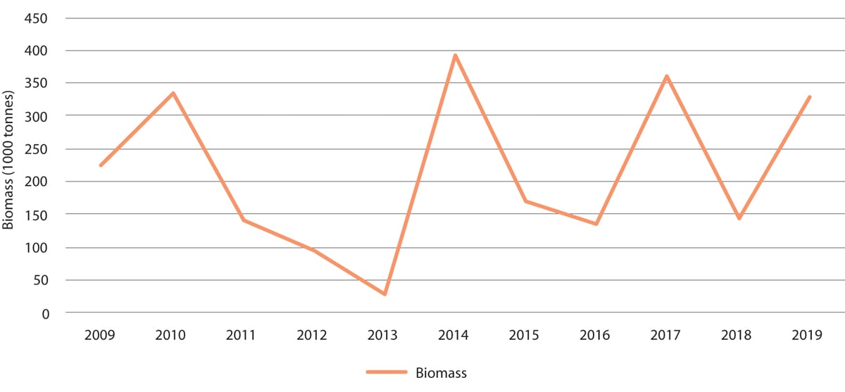
Figure 3.26 Measured biomass of sandeels (one year and older) in the Norwegian part of the North Sea, excluding the Viking Bank.
Source Institute of Marine Research/environment.no
The spawning stock of plaice rose from an estimated 200 000 tonnes in 2006 to a forecast 980 000 tonnes in 2018, and is now larger than when monitoring of the stock began in the 1950s. The ecological consequences of this change are unknown.
Seabirds and marine mammals
Overall seabird numbers in the North Sea and Skagerrak declined in the ten-year period 2007–2017. This was primarily due to a decline in the population of common eider and in breeding populations of large gull species such as the lesser black-backed gull. The reasons for the decline are largely unknown. The EU has recently finished phasing in a landing obligation banning discards of bycatches and unwanted catches. This will probably have a negative impact on seabird populations, since seabirds have until now fed on bycatches discarded by the fishing fleet. A landing obligation has been in force in Norwegian waters for much longer, and there will probably be no further impact on seabirds that forage in the Norwegian sector of the North Sea.
There has been little change in marine mammal populations in the last few decades. The porpoise population appears to be stable. The size of the only breeding colony of grey seals in the Norwegian part of the North Sea has not changed in recent years. An international survey of small cetaceans indicates that there are about 350 000 porpoises in the North Sea and Skagerrak. Porpoises are taken as a bycatch in fisheries, but the scale is unknown. The size of the minke whale stock has remained unchanged.
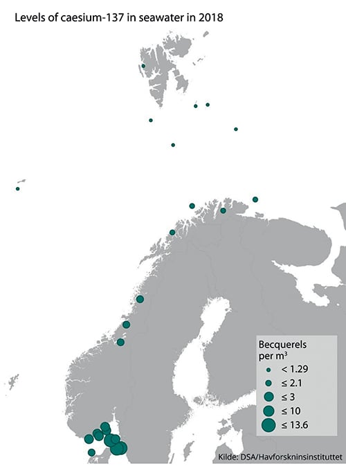
Figure 3.27 Levels of caesium-137 measured in seawater in 2018.
Source Norwegian Radiation and Nuclear Safety Authority/Institute of Marine Research
Alien species
Large numbers of the warm-water blue jellyfish Cyanea lamarckii have been observed in summer in the Skagerrak and eastern parts of the North Sea. In autumn, the comb jelly Mnemiopsis leidyi, an alien species, is being observed more and more frequently near the coast, especially from mid-August onwards. This species is largely associated with coastal waters, and densities in the open sea are low. Jellyfish are predators and may have major impacts on the planktonic food web.
3.3.3 Pollution
Inputs of pollutants to the management plan area via the atmosphere and rivers have generally been stable or declining since 2011. Inputs of persistent, bioaccumulative and toxic substances via the atmosphere and rivers have been stable or declining since 2011. Inputs of phosphorus, nitrogen and copper from fish farming along the coast of Western Norway rose steeply from 1990 onwards; the rise has continued after 2011, but has been less steep. It is uncertain to what extent these pollutants are transported out into the management plan area. On the whole, the extent of seabed affected by hydrocarbons from the petroleum industry has remained the same in recent years, but there has been a certain increase in some geographical areas. Since 2011, there has been no substantial change in the quantities of pollutants in produced water discharged from oil installations.
Levels of persistent, bioaccumulative and toxic substances in living organisms in the North Sea–Skagerrak management plan area are generally somewhat higher than in the Barents Sea–Lofoten area and the Norwegian Sea. Except for dioxins and dioxin-like PCBs in fish liver, and mercury in fillets of tusk from some areas, levels of most of these substances are below the maximum permitted levels in seafood. However, in most species the levels of mercury, PCBs and PBDEs exceed the low levels set in environmental quality standards, which are intended to protect species higher in the food chain such as seabirds and marine mammals. There are no grounds for concluding that there has been any change in pollution levels in living organisms in the North Sea since 2011.
Levels of radioactive pollution in seawater in the North Sea and Skagerrak are low, but somewhat higher than in the Norwegian Sea and the Barents Sea–Lofoten area. This is explained by proximity to the most important sources of radioactive pollution in Norwegian waters: the processing plants Sellafield in the UK and La Hague in France, and water flowing out from the Baltic Sea, which still contains pollutants originating from the Chernobyl accident. Levels of radioactive pollution in the marine environment have been gradually declining in recent decades. Levels of radioactive contamination (caesium-137) in fish and seafood are well below the maximum permitted level for seafood.
3.3.4 Particularly valuable and vulnerable areas
According to the scientific basis for the management plans, new knowledge obtained about the particularly valuable and vulnerable areas in the North Sea and Skagerrak does not indicate that there is any need to change the status of the existing areas. The updated knowledge base confirms the value and vulnerability of the previously identified areas. The particularly valuable and vulnerable areas and the species and habitat types found in them are further discussed in the Forum’s reports and in earlier white papers on the management plans.
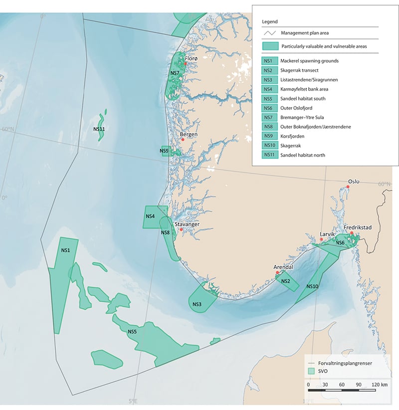
Figure 3.28 Particularly valuable and vulnerable areas in the North Sea–Skagerrak management plan area.
Source Norwegian Environment Agency
Parts of two of the particularly valuable and vulnerable areas, the Skagerrak and mackerel spawning grounds, are no longer included in the list because they are outside Norway’s jurisdiction and therefore do not come within the scope of the North Sea–Skagerrak management plan. The zone of coastal waters out to 25 km from the baseline was identified as a generally valuable area in the management plan for the North Sea and Skagerrak, but not as a particularly valuable and vulnerable area. However, the Forum for Integrated Ocean Management will consider the coastal waters of the North Sea-Skagerrak management plan area further in its review of the particularly valuable and vulnerable areas.
The original reason for identifying ‘mackerel spawning grounds’ as a particularly valuable and vulnerable area was that it includes the most important areas where the North Sea stock spawns in surface water in May–June. Mackerel is an ecologically and commercially important species in the North Sea. Atlantic water carrying mackerel eggs and larvae also flows into this part of the northern North Sea from mackerel spawning grounds west of Scotland and Ireland. The area is therefore valuable, but the part of it delimited as a particularly valuable and vulnerable area is not of greater importance for spawning than the waters around it. This is one of the areas the Forum for Integrated Ocean Management will consider further in its review.
3.4 Marine litter and microplastics
Marine litter and microplastics are causing growing environmental problems that are a threat to our continued sustainable use of the oceans, and may have impacts on ecosystems and threaten food safety and food security.
In 2017, the Government presented a white paper on waste policy and the circular economy (Meld. St. 45 (2016–2017)) including an integrated strategy to combat plastic waste. The 2017 update of the Norwegian Sea management plan included a separate chapter on plastic waste and measures and instruments to deal with the problem that are relevant to all three management plan areas. The status report for the Norwegian Sea published by the Advisory Group on Monitoring in 2019 includes more detailed and updated information on marine litter in all the management plan areas.
3.4.1 Marine litter – status and sources
In the North Sea, the amount of plastic in fulmar stomachs is used as an indicator of marine plastic pollution. This is a joint OSPAR indicator. Monitoring has shown a high but stable level of plastics in fulmar stomachs in the period 2005–2014. More than 60 % of the individuals sampled were found to contain more than 0.1 grams of plastic. Norway has adopted the OSPAR target that this level should be exceeded in less than 10 % of fulmars. In the Barents Sea and other parts of the Arctic, plastics have been found in the stomachs and pellets of several seabird species, including fulmar, little auk and Brünnich’s guillemot.
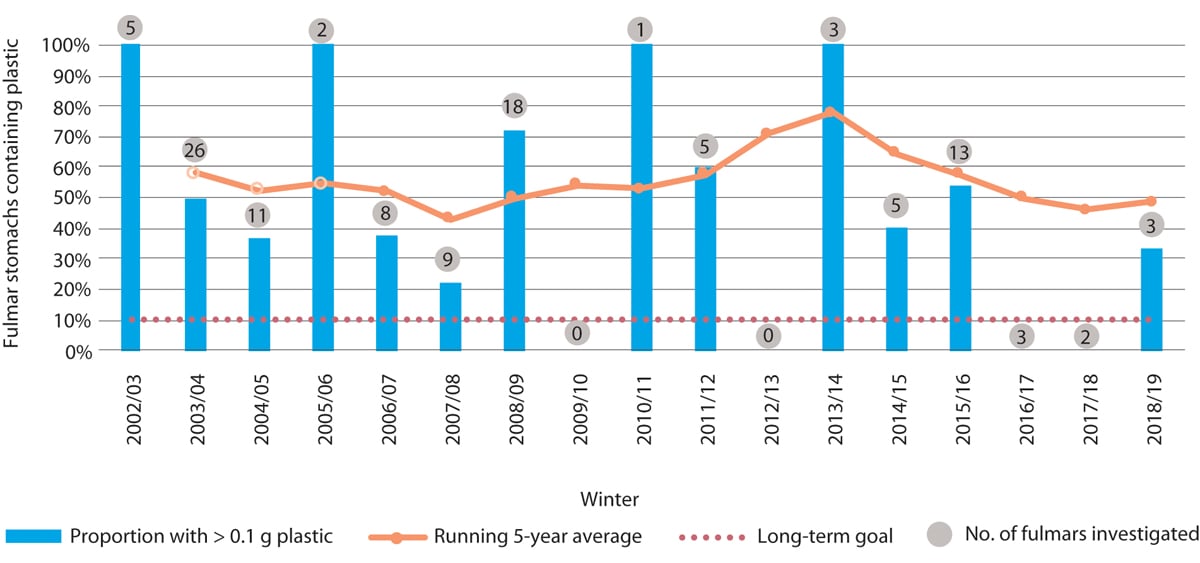
Figure 3.29 Percentage of fulmars in the North Sea found to have more than 0.1 g plastic in the stomach.
Source Norwegian Institute of Nature Research NINA
Our knowledge about plastics and microplastics in living organisms, whether in Norwegian waters or elsewhere, is limited. In Norway, microplastics have been found in organisms including mussels and other molluscs, cod, snow crab, Chinese mitten crab and marine worms. The levels detected have been low. In general, the smaller the size of the particles that can be detected by the analysis, the larger the number of particles found. Studies of animals have shown that the smallest particles can be absorbed into the tissues via the stomach. In addition to the effects of the plastics themselves, chemical additives and chemical contaminants on the plastics can be a problem. Furthermore, both pathogens such as bacteria and viruses and alien species found in or on plastics can be spread to new areas by ocean currents.
Many animals suffer injuries and die through becoming entangled in or ingesting plastics, and this has been well documented. However, little is known about the effects of plastic waste and microplastics at population or ecosystem level. A risk assessment by the Norwegian Scientific Committee for Food and Environment concluded that the risk of negative impacts is low at present, but that this situation could change over time.
Seven Norwegian beaches are included in the OSPAR beach litter monitoring programme. The monitoring results show little change in litter quantities over time, indicating that inputs of litter are not being reduced. At least 90 % of the litter is plastic. Litter has also been observed on the seabed in all areas that have been investigated, but there is not yet sufficient data to assess whether quantities are rising.
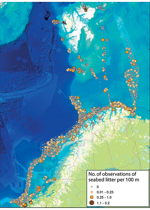
Figure 3.30 Observations of seabed litter in the Barents Sea and Norwegian Sea.
Source MAREANO
There are many different sources of marine litter, and it originates from a wide variety of activities both at sea and on land. Plastics make up the largest fraction of marine litter, and are the most serious problem. Microplastics originate from the degradation of plastic waste, sea-based sources such as ships’ paint and aquaculture, and inputs from a wide variety of land-based sources. The quantities of waste and microplastics that enter the marine environment from the different sources are very uncertain.
Registration of litter on beaches along the Norwegian mainland coast and the coast of Svalbard shows that consumer waste dominates in the southern part of the country, while sea-based sources including the fishing industry dominate further north and in Svalbard. This reflects differences in population levels and coastal activities. In areas that are heavily used for outdoor recreation, high levels of litter originating from these activities are registered. Plastic waste and microplastics are transported over long distances by ocean currents, between countries and continents, and some of the marine litter found in Norwegian waters thus originates from other countries. Microplastics also spread in the atmosphere, and are even found in the Arctic. There are indications that an accumulation zone for plastic waste and microplastics is forming in the Barents Sea. Microplastics may also accumulate in sea ice in the Arctic. Researchers believe that microplastics in seawater are trapped and may become concentrated in sea ice, and are released when the ice melts.
Observations from the MAREANO programme indicate that the fishing industry is one of the main sources of seabed litter in the Barents Sea and Norwegian Sea. About 40–60 % of all plastics registered in bottom trawl hauls in the Barents Sea are related to the fishing industry. A substantial proportion of beach litter consists of small plastic fragments and pieces of rope that cannot be traced back to an exact source. For Norwegian waters generally, fisheries, aquaculture and shipping have been identified as the main sources of marine litter. Estimates of the proportion of waste from different sources will depend partly on whether the calculations are based on the abundance, volume or weight of waste types.
A recent report from the consultancy SALT and the Nordland Research Institute estimates that the accumulated amount of litter along the coast of Norway originating from the seafood industries (fisheries and aquaculture) in Norway and internationally is in the order of magnitude of 100 million objects with a total weight of 10 000 tonnes. According to the report, explanations for releases of plastic waste from fisheries and aquaculture range from weaknesses in waste management systems, failure to follow routines, habit, wear and tear and a lack of maintenance, to deliberate dumping. Rope ends and net fragments are also commonly discarded during repairs at sea. The report describes the results of several studies that will provide a basis for action plans to be developed by the industries to reduce inputs of plastic waste to the marine environment.
3.4.2 Efforts to combat marine litter – status and further work
In the course of 2020, the Norwegian Environment Agency will present a new synthesis of knowledge about the sources of marine litter and microplastics in Norway, including sea-based sources such as the fisheries, aquaculture and shipping. Furthermore, GESAMP (the Joint Group of Experts on the Scientific Aspects of Marine Environmental Protection), an advisory body for the UN system, is working on a report on sea-based sources of marine litter across the world. In 2020, the Norwegian Environment Agency is to present proposals for supplementary action to reduce inputs of plastic waste and microplastics from sea-based sources, and knowledge about sources will be a vital basis for the proposals.
An updated, broader-based Norwegian strategy for combating plastic waste is also to be prepared in the light of new knowledge about the distribution, sources and effects of plastic waste, appropriate action, and experience of using various policy instruments. The strategy will deal with plastic litter and microplastics in the oceans, in freshwater and on land.
The Directorate of Fisheries organises an annual retrieval programme for lost fishing gear in Norwegian waters. Since this programme started in the early 1980s, more than 21 000 gill nets and 10 000 traps have been retrieved. The total weight of the gear retrieved is estimated at almost 1000 tonnes. Most of the gear retrieved has probably been lost by accident, but as late as 2019, fishing gear has been found that has clearly been deliberately abandoned. Norwegian fishermen are required to report the loss of fishing gear, and their reports provide part of the basis for determining the areas to be covered by the gear retrieval programme. In recent years, as much as 70 % of the gear retrieved has been returned to its owners.
The Fishing for Litter project has established a temporary scheme that allows fishing vessels to deliver marine litter taken as a bycatch in fishing gear in nine selected ports along the Norwegian coast, free of charge. The consultancy firm SALT Lofoten has been responsible for planning and implementing the scheme since 2015, with funding from the Norwegian Environment Agency. Two more ports are to be added to the scheme in 2020. The Government is now considering how to introduce legislation on the delivery of waste retrieved at sea free of charge, in line with the revised Port Reception Facilities Directive. Experience gained from the Fishing for Litter project will be an important basis for this work. In 2018, the Norwegian Environment Agency presented a review of producer responsibility for plastic waste from the fisheries and aquaculture. This is now being evaluated by the Ministry of Climate and Environment.
Since the refund scheme for end-of-life leisure craft was introduced in 2017, more than 20 000 boats have been delivered. The scheme is being expanded from 2020 to include aluminium boats and other boats with metal keels and ballast.
The Norwegian Environment Agency administers a grant scheme promoting action to reduce marine litter in Norway, including both removal of litter and preventive measures. The scheme focuses mainly on beach clean-up. In 2020, NOK 70 million has been allocated to the scheme.
The business sector also provides substantial funding for clean-up and removal of litter.
The voluntary organisation Hold Norge Rent (Keep Norway Clean) plays an important part in coordinating and providing advice on voluntary clean-up initiatives in Norway. The organisation also organises a network for cooperation between businesses, public authorities and voluntary organisations that are working to reduce marine litter and microplastics. Its operating grant is therefore to be increased from 2020.
The Norwegian Centre for Oil Spill Preparedness and Marine Environment is being established as a centre of expertise on the recovery and prevention of marine litter from sea-based sources. A key task is to establish a database and map service for information on beach litter clean-up as a basis for coordinated, effective efforts at national level. The centre will also be responsible for disseminating knowledge about the prevention of marine litter from sea-based sources.
The 2019 EU directive on reducing the impact of certain plastic products on the environment includes requirements for member states to introduce producer responsibility schemes for fishing gear, including aquaculture equipment. The EU has also revised the Port Reception Facilities Directive, which requires countries to provide adequate facilities for delivery of passively fished waste in their ports. The Norwegian authorities are taking steps to implement the requirements of these two directives.
3.5 Status report: progress towards the goals of the ocean management plans
The Forum for Integrated Ocean Management has reviewed progress towards the goals of the ocean management plans, and the results are summarised below. The report is based on the goals as they were formulated in earlier management plans. These goals have largely been retained in the present white paper, but their wording has been harmonised for all three management plan areas. The new goals are set out in full in Chapter 2.4.
Safe seafood
Fish and other seafood will be safe and will be perceived as safe by consumers in the various markets. Current knowledge indicates that this goal has been achieved for the Barents Sea–Lofoten management plan area, and partly achieved for the Norwegian Sea and the North Sea and Skagerrak. Levels of hazardous substances and radioactive substances are generally low and largely under the maximum permitted levels in seafood. However, concentrations above the permitted levels may be found in individual species in certain areas and in some specimens of species at high trophic levels, such as halibut. Levels of hazardous substances may also exceed the maximum permitted levels in fish liver and edible crabs. In some cases, measures such as prohibiting catches or advising against consumption have been introduced to ensure that seafood is safe. For example, in October 2017, catches of halibut from the outer Sklinnadjupet trench were banned and a requirement to discard all halibut exceeding two metres in length was introduced.
Activities in the Norwegian Sea and in the North Sea and Skagerrak will not result in higher levels of pollutants in seafood. The main source of pollutants found in seafood is probably activity outside the management plan areas. It is very uncertain how much activity within the North Sea–Skagerrak management plan area contributes to contamination of seafood, and knowledge is limited. The goal is considered to have been achieved for hazardous substances in the North Sea and Skagerrak. It is uncertain whether the goal has been achieved for the Norwegian Sea because of a lack of knowledge about the sources of the hazardous substances found as contaminants in seafood.
Environmentally hazardous substances
Environmental concentrations of hazardous and radioactive substances will not exceed the background levels for naturally occurring substances and will be close to zero for man-made synthetic substances. Releases and inputs of hazardous or radioactive substances from activity in the management plan areas will not cause these levels to be exceeded. There are still inputs of hazardous and radioactive substances to all three management plan areas, and the goals for hazardous substances have not generally been achieved. This conclusion is based on an overall evaluation of the available knowledge about inputs and levels of hazardous and radioactive substances.
Operational discharges from offshore petroleum activities and shipping
Operational discharges from activities in the management plan areas will not result in damage to the environment or elevated background levels of oil or other environmentally hazardous substances over the long term. There are substantial operational discharges from petroleum activities in the North Sea, which are resulting in rising background levels of oil, other environmentally hazardous substances and naturally occurring radioactive substances over time. There are also discharges of naturally occurring environmentally hazardous substances, naturally occurring radioactive substances and environmentally hazardous substances with produced water from petroleum activities in the Norwegian Sea. Levels of pollution in the Norwegian Sea are generally low, and it is unlikely that operational discharges from petroleum activities or shipping are causing environmental damage. However, there is still uncertainty about the damage that operational discharges may cause, including the possible long-term effects of drill cuttings on corals and sponges. The goal is therefore not considered to have been achieved for operational discharges from petroleum activities in these two management plan areas.
Operational discharges in the Barents Sea–Lofoten management plan area are limited, and are not thought to be resulting in rising background levels of oil or other environmentally hazardous substances or naturally occurring radioactive substances over time.
Operational discharges of oil in bilge water to the management plan areas are small and have not so far resulted in detectable changes in ecosystems. A lack of knowledge means that it is uncertain whether the goal has been achieved for operational discharges of environmentally hazardous substances (stern tube lubricants) from shipping.
Marine litter
Inputs of litter that have negative impacts on coastal waters, the sea surface, the water column or the seabed will be reduced. An overall evaluation of current knowledge indicates that the goal has not been achieved for any of the management plan areas. Large quantities of litter are being registered at many localities along the coast, in trawls, during mapping of the seabed and in the stomachs of seabirds and other animals. The results of beach litter monitoring indicates that there has been no decline in the number of objects found on the reference beaches since the previous report, even though there are regular beach clean-up operations on these beaches.
Monitoring of marine litter is inadequate, and there are gaps in our knowledge about environmental damage and inputs of litter from sources within and outside the management plan areas.
Risk of acute pollution
The risk of damage to the environment and living marine resources from acute pollution will be kept at a low level and continuous efforts will be made to reduce it further. Maritime safety measures and the oil spill preparedness and response system will be designed and dimensioned to effectively keep the risk of damage to the environment and living marine resources at a low level.
The risk of accidents in connection with petroleum activities is assessed as low in all three management plan areas. The goal is considered to have been achieved, which reflects the effectiveness of preventive measures during the reporting period and indicates which measures will be useful in preventing accidents in future.
The potential environmental consequences of spills vary from area to area and through the year, particularly depending on where and when seabirds are most vulnerable, and this affects the level of environmental risk. The discharge potential in the Barents Sea South, particularly the northern parts of this area, is considerably lower than elsewhere on the Norwegian continental shelf. Even so, the level of environmental risk for seabirds in the open sea is generally higher in the Barents Sea–Lofoten area than in the Norwegian Sea and the North Sea–Skagerrak, because larger numbers of vulnerable seabirds are present for much of the year. The goal of keeping the risk of damage to the environment and living marine resources at a low level is therefore not considered to have been achieved for the Barents Sea–Lofoten management plan area, even though the risk of accidents is low.
The environmental risk associated with fields that are on stream in the Norwegian Sea and the North Sea–Skagerrak is considered to be unchanged. There has been a high level of environmental risk associated with certain activities, and a need for risk-reduction measures, particularly to deal with high discharge rates and activity near the coast. The goal is therefore only considered to have been partially achieved.
Risk-reduction measures that have been implemented have reduced the risk of accidents resulting in spills from shipping in the management plan areas. Only a few accidents result in acute pollution, and the goal of reducing the risk of damage to the environment is considered to have been partially achieved. However, no specific assessments have been made of levels of environmental risk or any changes in these levels.
The volume of nuclear-powered shipping in all three management plan areas is rising, as is the volume of radioactive cargo in the Russian part of the Barents Sea. The goal of reducing the risk of environmental damage from these activities is therefore not considered to have been achieved.
The oil spill preparedness and response system at private, municipal and governmental level is risk-based. The preparedness and response system has been strengthened and various measures have been introduced at governmental level and by the oil and gas companies. However, it is difficult to verify how much these measures would reduce the consequences of spills, and the extent to which the goal has been achieved is uncertain.
Norway’s nuclear emergency preparedness system for Norwegian waters has been strengthened to some extent, but further improvements are needed in the resources available for monitoring and measuring radioactivity and in action that can be taken to prevent releases of radioactivity from disabled ships.
Underwater noise (North Sea–Skagerrak management plan area)
Activities entailing a noise level that may affect species’ behaviour will be limited to avoid the displacement of populations or other effects that may have negative impacts on the marine ecosystem. No indicators have been established to show trends in underwater noise levels from activities in the management plan areas and their environmental consequences. Too little is known about whether there are clear links between noise levels from various activities and the impacts on ecosystems. It is therefore not possible to determine the extent to which the goal has been achieved.
Nutrients, sediment deposition and organic material (North Sea–Skagerrak management plan area)
Anthropogenic inputs of nutrients, sediment deposition and inputs of organic matter will be limited in order to avoid significant adverse impacts on biodiversity and ecosystems in the management plan area. Inputs of nutrients from the Norwegian mainland are rising, but no significant adverse impacts have been demonstrated in the form of eutrophication or sediment deposition in the management plan area. However, given the rising inputs, the goal is not considered to have been achieved.
Climate change and ocean acidification (North Sea–Skagerrak management plan area)
When marine ecosystems are used as carbon sinks, the need to maintain biodiversity and natural ecosystem functions will be taken into account. At present, there is no activity in the management plan area that makes use of marine ecosystems as carbon sinks. It is very difficult to draw any conclusions about trends in the cumulative impacts of human activity on species and habitat types that are affected by climate change and ocean acidification, and whether these impacts have been minimised.
Particularly valuable and vulnerable areas and habitats
Activities in particularly valuable and vulnerable areas will be conducted with special care and in such a way that the ecological functioning and biodiversity of such areas are not threatened. This goal is considered to have been achieved for some particularly valuable and vulnerable areas and partially achieved for others, meaning that some of the ecosystem components that are evaluated are showing a positive trend, while others are stable or showing a negative trend. In some particularly valuable and vulnerable areas, it is uncertain whether the goal has been achieved. It is often uncertain whether and to what extent human activity within a specific area affects its ecological functioning or biodiversity. Fishing operations, particularly trawling, have been carried out in several of these areas for many years. Fisheries inevitably leave a footprint, and this has been taken into account in assessing how far the goal has been achieved. In addition, biodiversity and pressure from human activities have not been adequately mapped for all the particularly valuable and vulnerable areas. Because of overexploitation of the lobster stock and possible indirect effects of human activity on seabird populations, the goal is not considered to have been achieved for three particularly valuable and vulnerable areas: the Skagerrak transect, the Outer Oslofjord and the Skagerrak.
Damage to marine habitats that are considered to be endangered or vulnerable will be avoided. In assessing progress towards the goal, human activity in the management plan areas has been taken into account. Damage is taken to mean damage that can have effects at population level and on biodiversity, not damage to individual specimens of animals or plants. Progress towards this goal is also variable: it has been achieved or partially achieved for some habitat types, while a lack of knowledge makes progress difficult to assess for other habitat types. The goal has not been achieved for two habitat types: Isidella lofotensis coral gardens and fine-sediment seabed in deep water in the Skagerrak.
Species management
Naturally occurring species will exist in viable populations that provide for sufficient reproductive capacity and long-term survival, and genetic diversity will be maintained. This goal has been achieved for all the large commercial fish stocks and for marine mammals that are harvested, but it is more uncertain whether it has been achieved for fish stocks that are not commercially harvested and for benthic organisms. The goal has not been achieved for seabirds, some of the smaller commercial fish stocks and hooded seals in the Norwegian Sea.
Species that are essential to the structure, functioning and productivity of ecosystems will be managed in such a way that they are able to maintain their role as key species in the ecosystem concerned. The goal is considered to have been achieved for the management of key species in all three management plan areas.
Populations of endangered and vulnerable species and species for which Norway has a special responsibility will be maintained or restored to viable levels. The goal has not been achieved; populations of many endangered and vulnerable species and species for which Norway has a special responsibility are not at ‘viable levels’ according to the 2015 Norwegian Red List.
The introduction and spread of alien organisms through human activity will be avoided. The goal has not been achieved for the North Sea–Skagerrak management plan area. It is uncertain whether it has been achieved in the other management plan areas. There is inadequate monitoring of alien organisms that are spread with ballast water or on ships’ hulls, so that it is not possible to assess progress towards the goal for such species. It is too early to observe any effects of the implementation of the Ballast Water Management Convention, which entered into force in 2017.
Conservation of marine habitat types
The establishment of marine protected areas in Norway’s coastal and marine waters will contribute to an internationally representative network of marine protected areas. The goal is not considered to have been achieved in any of the management plan areas because much more work remains to be done on implementation of the marine conservation plan, and because the marine protected areas that have been established are not yet considered to provide a representative network that will maintain the full range of variation of habitat types.
Sustainable harvesting/use
Management of living marine resources will be based on the principles of sustainable harvesting. This goal has been achieved for all stocks that are harvested in the Norwegian Sea, including both large and small commercial stocks.
Living marine resources will be managed sustainably through the ecosystem approach based on the best available knowledge. Harvesting will not have significant adverse effects on other parts of the marine ecosystem or its structure. These goals are considered to have been achieved for the North Sea–Skagerrak management plan area.
Bycatches of marine mammals and seabirds will be minimised. It is uncertain whether this goal has been achieved for the North Sea–Skagerrak management plan area.
Living marine resources will be harvested making use of the best available techniques for different types of gear to minimise negative impacts on other ecosystem components such as marine mammals, seabirds and benthic communities. This goal is considered to have been achieved for the North Sea–Skagerrak management plan area.
Harvested species will be managed within safe biological limits so that their spawning stocks have good reproductive capacity. This has been achieved for species in the Barents Sea–Lofoten area, with the exception of coastal cod and golden redfish. The goal has now been achieved for red king crab, which is an improvement since 2010.
3.6 Knowledge building and knowledge needs
Norway gives priority to knowledge-based, integrated and responsible ocean management. Sound management of Norwegian waters must be based on a sound knowledge base built up through mapping, research and environmental monitoring. This chapter outlines the main knowledge needs in various areas. Earlier management plans and the Government’s long-term plan for research and higher education have also included an account of significant knowledge needs. Norway’s ocean management regime is based on a considerable body of knowledge, but there are still major gaps in our knowledge and understanding of the marine environment, and further mapping, research and monitoring are needed. Further developing our understanding is a vital basis for sustainable management of marine ecosystems.
Climate change, ocean acidification and inputs of pollutants such as hazardous substances and plastic waste are changing the oceans. The scale of these changes is already greater than we have experienced historically as a result of natural variability, and will increase further (see Chapter 4). This is affecting not only the marine environment, but also the basis for future ocean industries. Knowledge about these changes and the ability to predict and counteract them is of critical importance, both for the management of species and ecosystems and for further development of ocean industries. Such knowledge will also facilitate environmental improvements and strengthen green competitiveness in maritime industries.
3.6.1 The ocean environment and climate change
Marked changes have been observed in all three management plan areas as a result of climate change. These changes are expected to continue and become more pronounced over time. Together with ocean acidification, climate change is expected to affect not only ocean temperatures, but also ocean currents, ice conditions, extreme weather events, wave height and chemical conditions such as the pH of seawater and its oxygen content. Physical and chemical data from different seasons are therefore needed to learn more about year-to-year changes and put us in a position to understand changes in ocean climate and ocean acidification.
Furthermore, research will be needed to develop methods and models that will improve predictions of how climate change and ocean acidification will affect basic ecological variables and processes such as primary production, species and stock size and distribution, and future catch potential.
Textbox 3.4 The Nansen Legacy project
Figure 3.31 The Nansen Legacy: sampling from the RV Kronprins Haakon in the northern Barents Sea in December 2019.
Photo: Robin Hjertenes, Institute of Marine Research
The Nansen Legacy research project started in 2018, and is intended to improve scientific understanding of climate change and marine ecosystems in the central and northern parts of the Barents Sea. It involves cooperation between ten Norwegian research institutions.
In 2019, five research cruises were carried out, mainly using the ice-class research vessel Kronprins Haakon. Interdisciplinary data have been collected that show interannual variability in ice cover and water temperature in the northern Barents Sea. A cruise during the polar night in December 2019 found unexpectedly large numbers of organisms in icy waters in areas of drift ice, and considerable reproductive activity under the ice. Data collected from measuring instruments deployed for more than a year in the Barents Sea shows a considerable inflow of warm Atlantic water into the Barents Sea from the north, which had not previously been observed.
Preliminary analysis of geological cores from bottom sediments has provided a better understanding of sea ice dynamics in the Barents Sea since the last ice age. Analyses of historical ecosystem data from the Barents Sea show how the ocean climate influences the dynamic relationship between zooplankton and fish, which has important implications for sustainable management.
The project includes 40 early career scientists, who are working together with established researchers to collect and analyse data. In future, these young researchers will form the backbone of marine polar research in Norway, across disciplines and institutions.
The project is also focusing on outreach, communicating research questions and results to a wide audience through a variety of channels. Target groups include young people, the general public, researchers, decision makers and various interest groups.
3.6.2 Marine ecosystems
Knowledge about the marine environment, marine ecosystems and processes in the oceans makes it possible to follow environmental status and trends in the management plan areas, manage the way they are used, and understand relationships between pressures and impacts on ecosystems, habitat types and species. A better understanding of functions and the natural interplay between different components of marine ecosystems is of key importance for sustainable ocean management.
There is also a pressing need for more knowledge about the ecosystem impacts of climate change and ocean acidification. This includes both knowledge about how climate change and ocean acidification are affecting ecosystems today, and knowledge that will improve our ability to predict future changes and provide a better basis for management. We need more knowledge and a deeper understanding of the pressures on ecosystems caused by factors such as harvesting, pollution, alien species and plastic waste and microplastics (see Chapter 3.6.4). Underwater noise is another example of an area where little is known about effects on marine species.
Human activity both at sea and on land is putting pressure on marine ecosystems. It is vital to develop an overall understanding of the cumulative impacts of the whole range of activities. We do not know enough about cumulative impacts, for example to what extent multiple impacts at individual level translate into population-level impacts. Further development of a harmonised scale for pressures and impacts from different sectors is needed, and methods for assessing cumulative impact and environmental impacts also need to be further developed. In the case of climate change, more needs to be learned about how reducing other pressures can help to maintain ecosystem functioning and make ecosystems more resilient, and how different policy instruments and combinations of them can be used most effectively to achieve this.
Major changes are taking place in seabird populations along the coast. Further studies are needed to identify the causes and find links between ecosystem processes and population changes. Some studies suggest that there are close links between the ocean climate, larval drift and declining seabird populations. More knowledge is also needed about seabird habitat use throughout the year.
Moreover, we need to strengthen the knowledge base on the ecosystem impacts of harvesting new species or new ecosystem components. These include the copepod Calanus finmarchicus and mesopelagic fish species, and research must include changing climatic conditions that may result in shifts in species distribution.
3.6.3 Mapping the seabed
Mapping of the seabed in Norwegian waters should be continued. The MAREANO programme, which started in 2005, maps depth and topography, sediment composition, biodiversity, habitats and biotopes, and pollution on the seabed in Norwegian waters. By the end of 2019, depth data were available for 28 % of Norway’s marine and coastal waters. Maps of sediments and biotopes were available for 10 % and 7 % respectively of marine and coastal waters.
The MAREANO programme is important as a basis for integrated, ecosystem-based management of Norwegian seas and oceans. It is important to continue this work to build up knowledge about seabed habitat types and biotopes with important functions, and about the resilience and vulnerability of marine benthic ecosystems to different pressures and to cumulative impacts, based partly on data from the MAREANO programme.
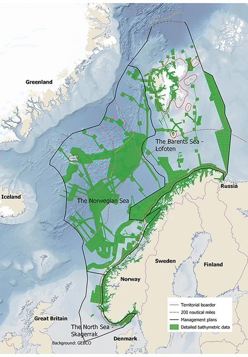
Figure 3.32 Areas where the MAREANO programme has mapped depth and topography or obtained data from other sources.
Source MAREANO
3.6.4 Marine litter and microplastics
More knowledge is needed about plastic waste, microplastics and nanoplastics, including sources, pathways of dispersal, and impacts on the fauna, ecosystems, ecosystem services, food safety and health. Research and innovation is also needed to find effective and environmentally sound ways of preventing and reducing inputs of marine litter and microplastics.
Standardised methods and indicators for measuring and monitoring plastics in the marine environment are essential for following trends in quantities and types of plastic over time.
Better data are also needed as a basis for evaluating measures and assessing their effects. Methods and indicators should be developed through international cooperation, including work within the OSPAR framework.
Mapping and monitoring of plastic waste and microplastics in the marine environment in Norway should be expanded and used in the international knowledge base and international cooperation.
3.6.5 Environmental monitoring
There is a need to further develop several of the indicators used for environmental monitoring or to improve reporting by making the information more accessible or improving the monitoring system. A closer focus on species composition is needed, including species at lower trophic levels, and more time series are needed on population size and habitat use. These developments are needed to make it possible to assess value and vulnerability on a smaller scale (both temporal and spatial). There are also gaps in the monitoring of benthic communities, alien species, threatened species and pollution.
Monitoring of pressures and impacts associated with human activity needs to be further developed. We also need to improve our understanding of which changes are caused by pressures from human activity in the management plan areas or adjoining coastal waters and land, and which are related to climate change and other large-scale processes or to natural processes and variability in the oceans. This applies particularly to pressures on areas identified as valuable and vulnerable. Better and more cost-effective methods also need to be developed for use in mapping and monitoring Norwegian waters.