3 Norway’s history in the Antarctic
Summary
Norwegian Antarctic history is rooted in the pioneering exploration and whaling activities conducted by Norwegians in the 1890s and subsequent decades. Whaling came to play a major role in the Norwegian economy, affecting growth, employment levels and foreign trade. Uncertainties over sovereignty issues, meanwhile, made good relations with the United Kingdom (the leading actor in Antarctica) a policy priority for Norway. Whaling concerns were the main reason for Norwegian annexations in the Antarctic and subAntarcic during the interwar period – at Bouvetøya (1928), Peter I Øy (1931) and Dronning Maud Land (1939). All of these areas received status as Norwegian dependencies. The Antarctic Treaty, which entered into force in 1961, created a new framework for Norway’s Antarctic policy. Since then, the policy has accentuated research activity and protection of the unique environment in addition to active contributions to international collaboration under the Antarctic Treaty.
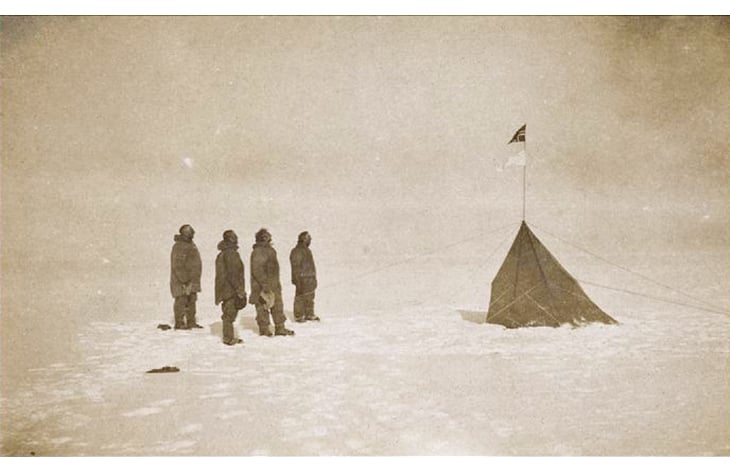
Figure 3.1 Roald Amundsen’s South Pole Expedition, 1911.
Source National Library in Australia.
Textbox 3.1 Pioneer era I: Early Norwegian activity in the south
Shipping company owner Lars Christensen’s 1892 Jason expedition, under the leadership of Captain C. A. Larsen, launched Norwegian activities in the south. Subsequently, another Norwegian, Carsten Borchgrevink, lead the British Southern Cross Expedition, which became the first to overwinter on the Antarctic mainland – at Cape Adare in 1898–1900. The station building, prefabricated at Strømmen Trævarefabrik in Norway, is still on site. It is the only place on earth where the first edifice ever erected on a continent remains standing. The station has been maintained by the New Zealand Antarctic Heritage Trust with financial support from, among other benefactors, the Norwegian Government.
Polar historians are in disagreement over who first set foot on the Antarctic mainland. The best-documented incident involves people from the Norwegian whaling expedition on the vessel Antarctic, which sailed to the Ross Sea in 1894–1895. On 24 January 1895, eight men from the ship, including Carsten Borchgrevink, Captain Leonard Kristensen and Expedition Chief Henrik Bull, went ashore at Cape Adare.
Figure 3.2 Per Savio, one of two Sami members of Carsten Borchgrevink’s 1898–1900 expedition.
Photo: Norwegian Polar Institute.
3.1 Historic backdrop
3.1.1 Exploration and early presence
Norwegian Antarctic history is inextricably tied to the exploration and whaling activities of the 1890s and decades thereafter. Via these exploits in the Southern Ocean and on the icy continent itself, the Norwegian pioneers of that time gave Norway’s polar identity its southern, Antarctic dimension.
The whaling station and graveyard in Whalers Bay, on Deception Island, and Carsten Borchgrevink’s cabins at Cape Adare are important Norwegian heritage sites. Nine Norwegian heritage sites appear on the Antarctic Treaty System’s list of historic sites and monuments in Antarctica. Roald Amundsen’s South Pole tent, last seen when Robert F. Scott’s group arrived at the spot a month after Amundsen, is also on this list. Additional information about internationally recognised Norwegian heritage sites can be found in Chapter 7.3.
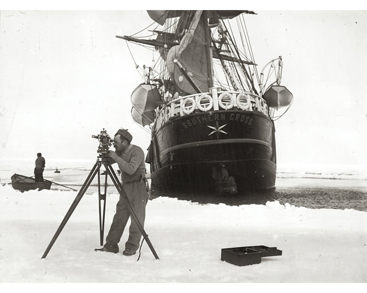
Figure 3.3 Carsten Borchgrevink surveying during his 1898–1900 Antarctic expedition. This was the first expedition to overwinter on the Antarctic mainland.
Photo: Norwegian Polar Institute.
Textbox 3.2 Pioneer era II: Voyages of discovery
Foremost among Norway’s pioneering explorers is Roald Amundsen – the man whose conquest of the South Pole would carry his country’s name to all corners of the world. On his first journey south, he served as First Mate on the scientific Belgica Expedition, which became trapped in the ice in the Bellingshausen Sea in 1898, making its members the first to overwinter in Antarctic waters. The next time Amundsen came to Antarctica it was as the leader of the Fram expedition of 1910–12. On 14 December 1911 Amundsen made history when he and four companions – Olav Bjaaland, Helmer Hanssen, Sverre Hassel and Oscar Wisting – planted the Norwegian flag at the South Pole. The expedition members discovered large areas that were named and taken into possession on behalf of the King of Norway. No formal occupation by Norwegian authorities took place, however.
Norwegians were also among the first to use aircraft in exploring the Antarctic Continent. The first flyover of the South Pole was executed by the Norwegian Bernt Balchen, on 28–29 November 1929, on Richard Byrd’s expedition. Other Norwegian air pioneers in the Antarctic included Hjalmar Riiser-Larsen, Finn Lützow-Holm and Viggo Widerøe, who aerially photographed and mapped Dronning Maud Land in the years from 1929 to 1937.
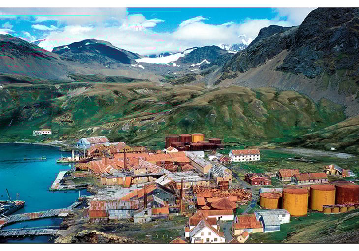
Figure 3.4 The whaling station at Grytviken, South Georgia, established in 1904. This picture is from the NARE expedition of 1989–90.
Photo: John Snuggerud, Norwegian Polar Institute.
3.1.2 Political context of Norway’s Antarctic claims
During the interwar period Norwegian claims in the Antarctic dealt primarily with the challenges of the Norwegian whaling industry. At the time that industry played an important role in Norway’s national economy, creating wealth, employment and foreign trade. But even though Norway was the dominant country in the whaling fields of the Southern Ocean, its position, politically speaking, was highly vulnerable. Fears arose that Norway’s vital whaling industry could be harmed by other countries’ policies – above all by the threat of exclusion from productive waters as a result of sovereignty claims by other countries on either the Antarctic mainland or islands in the surrounding ocean. Such fears were not groundless. The United Kingdom and the former British colonies of New Zealand and Australia pursued an active expansion policy that included both large territorial claims and licensing charges for Norwegian whaling, even on the high seas.
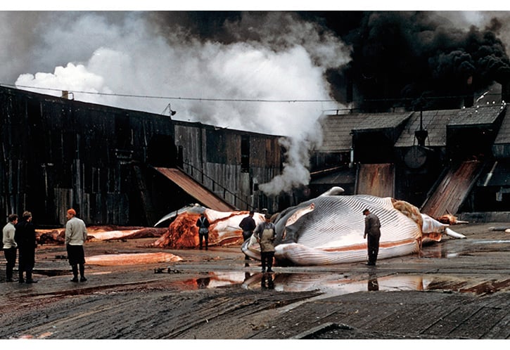
Figure 3.5 A whale on the flensing platform at Husvik, South Georgia, in 1956.
Photo: John Snuggerud, Norwegian Polar Institute.
Britian’s aim for dominance in the Antarctic was evident as early as 1904, when C. A. Larsen raised the British flag at the whaling station in South Georgia, an island group that previously had been considered more or less ownerless. In the following years, the UK submitted claims of sovereignty over South Georgia and several island groups further south, and from 1908 onward, over the entire Antarctic Peninsula from 20° W to 80° W longitude (the whole region becoming known as the Falkland Islands Dependencies). In 1923 the British claimed a sector-shaped portion of the Antarctic mainland between 160° E and 150° W longitude (the Ross Dependency, which was placed under the sovereignty of New Zealand). The next year, France stepped forward to claim a narrow sector, from 136° E to 142° E longitude. At the British Imperial Conference of 1926, a statement was adopted asserting that certain areas of Antarctica belonged to the United Kingdom by virtue of their discovery, as claimed, by British persons. This ‘wish list’ covered approximately 40 per cent of the Antarctic mainland. Though lacking the legal force of annexation, the statement was an important declaration of the political ambitions of the British Empire in Antarctica. These ambitions were realised by British Royal Order on 7 February 1933, when the areas identified during the Imperial Conference were annexed and assigned to Australia (the Australian Antarctic Territory – the entire sector from 45° E to 160° E longitude, apart from the French claim area). In this way the British Commonwealth of Nations (later renamed simply the Commonwealth of Nations) ended up claiming sovereignty over two-thirds of the Antarctic mainland and islands.1
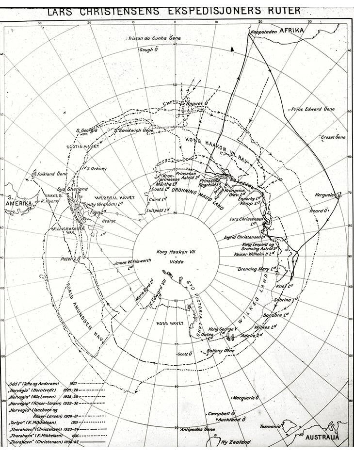
Figure 3.6 Map showing the routes taken by Lars Christensen’s expeditions.
Source Norwegian Polar Institute’s picture archive.
Textbox 3.3 Pioneer era III: Whaling
The Jason Expedition in 1892 started a prolonged period of Norwegian whaling activity in Antarctica. At first, fur seal harvesting was the primary draw, but it soon became clear that whales were the most valuable resource in the Southern Ocean. Large-scale whaling in the early years was almost entirely a Norwegian enterprise. The first vessels were of quite simple design, so efficient operations required good harbours with fresh water where the whales could be flensed and processed. C. A. Larsen set up the first land-based whaling station, in Grytviken, South Georgia, in 1904 after joining forces with the expatriate Norwegian Don Pedro Christoffersen and other prominent persons in Buenos Aires to establish the whaling company «Compañia Argentina de Pesca». This alliance marked the start of large-scale Norwegian whaling in the Southern Ocean an enterprise which included the construction of large island-based production plants, particularly in South Georgia. On Deception Island near the Antarctic Peninsula, the expatriate Norwegian Adolf Andresen, who lived in Chile, adopted Whalers Bay as a whaling outpost in 1906, and in 1912 the Norwegian company Hektor AS established a station there. By 1914, 21 factory ships and six land-based stations were operating in the Southern Ocean, with 62 whaling vessels using their services.
With the introduction of advanced whale-processing vessels by Norwegian shipping companies in the early 1920s, Norway clearly dominated the whaling fields of the Southern Ocean. In the 1930/1931 season (when the total catch reached its historic peak), 27 of the 41 Antarctic whaling expeditions were Norwegian; what’s more, most of the crewmembers on expeditions from other countries were Norwegian nationals. Other countries eventually joined the hunt in greater numbers with British, Japanese, Soviet, German and Dutch whalers coming to represent an ever-greater share of the activity. Norway’s role in the Antarctic whaling industry diminished after World War II, and ended in 1967. International whaling led to overexploitation of whale stocks in the Southern Ocean, and from the 1950s onwards Norway worked actively to limit the catch. Experience gained from the Southern Ocean has contributed to the development of sustainable management principles for ocean resources.
All the same it was the British dominance at sea that caused the most anxiety in Norway. Yet out of concern for the whaling industry, one of the main tenets of Norwegian Antarctic policy was to establish and maintain the smoothest possible relations with the UK and the rest of the Commonwealth.
3.1.3 Norwegian annexations in the Antarctic: Peter I Øy (1931) and Dronning Maud Land (1939)
In 1927 a shift occurred in Norwegian policy related to the Antarctic. The new course required a more active strategy, with the goal that Norway, too, would become a claimant in the Antarctic. Things had begun to change in 1926, with whaling ship owner Lars Christensen’s preparations for the first in what would become a series of exploratory expeditions to the Antarctic (with the vessels Odd, Norvegia and Torshavn). Under authority granted by the Ministry of Foreign Affairs on 31 August 1927, Christensen authorised the leader of the Norvegia I Expedition, Captain Harald Horntvedt, to annex any new land he found and to go ashore on the assumption that it was not already occupied by any other country. On 1 December 1927, the expedition went ashore and annexed Bouvetøya, at 54° 25’ S latitude and 3° 21’ E longitude. The circumstances of the annexation are described in more detail in a separate White Paper on Bouvetøya.
Peter I Øy
In 1928 Lars Christensen provisioned the second Norvegia Expedition, which – like the one before – was given annexation powers in Norway’s name for all new land the expedition might discover. On 2 February 1929 the expedition went ashore on Peter I Øy, and claimed the island for Norway.
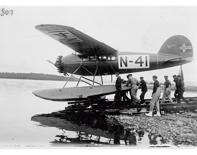
Figure 3.7 From the third Norvegia Expedition, 1929–30, showing aircraft N-41, which Hjalmar Riiser-Larsen used in mapping Dronning Maud Land.
Photo: Norwegian Polar Institute.
Peter I Øy lies 450 km off the west coast of Antarctica, at 68° 50’ S latitude and 90° 35’ W longitude. The island, about 180 km2 in area, had been discovered by Russian Admiral Fabian Gottlieb von Bellingshausen on 21 January 1821 and named after Tsar Peter I of Russia. Pack ice made it impossible for Bellingshausen to get closer than 25 km from the island. It was the first bit of land discovered south of the southern Polar Circle, and was therefore also the southernmost point to have been discovered at that time. But no one had set foot on the island until the Norvegia Expedition arrived, and no country – including Russia – had ever claimed it.
The island lie was not within (or near) the area identified in the declaration issued at the British Imperial Conference. When it became clear that scarcely anyone would stand in the way of placing the island under Norwegian sovereignty, the annexation was affirmed by the government through a Royal Decree on 6 March 1931. The legal status of the island was determined by legislative amendment on 24 March 1933, when Peter I Øy became a Norwegian dependency. More information is provided in Chapters 5.1 and 5.2. Norway’s then Ministry of Trade was given the task of administering the island by Royal Decree on 13 July 1933, with the same powers as that of a county governor. The duties of Police Chief went to the then Ministry of Justice.
Dronning Maud Land
The various expeditions that Lars Christensen equipped each year in the 1926–1937 period were responsible for discovering and mapping vast areas in the part of the Antarctic mainland facing the Atlantic Ocean. These ground-breaking discoveries and surveys by Norwegian explorers and expedition leaders gave the country the basis, under the law as ordinarily understood, for a possible annexation claim over the entire stretch of coast from approximately 16° 30’ W to 45° E longitude, including large parts of the interior. A major concern at the same time was to avoid coming into conflict with the United Kingdom. Active dialogue between the two governments and additional input from private actors resulted in a favourable British view of Norway’s Antarctic interests. On several occasions from 1933 onwards, the British expressed amenability to a potential Norwegian sovereignty claim on the Antarctic mainland.
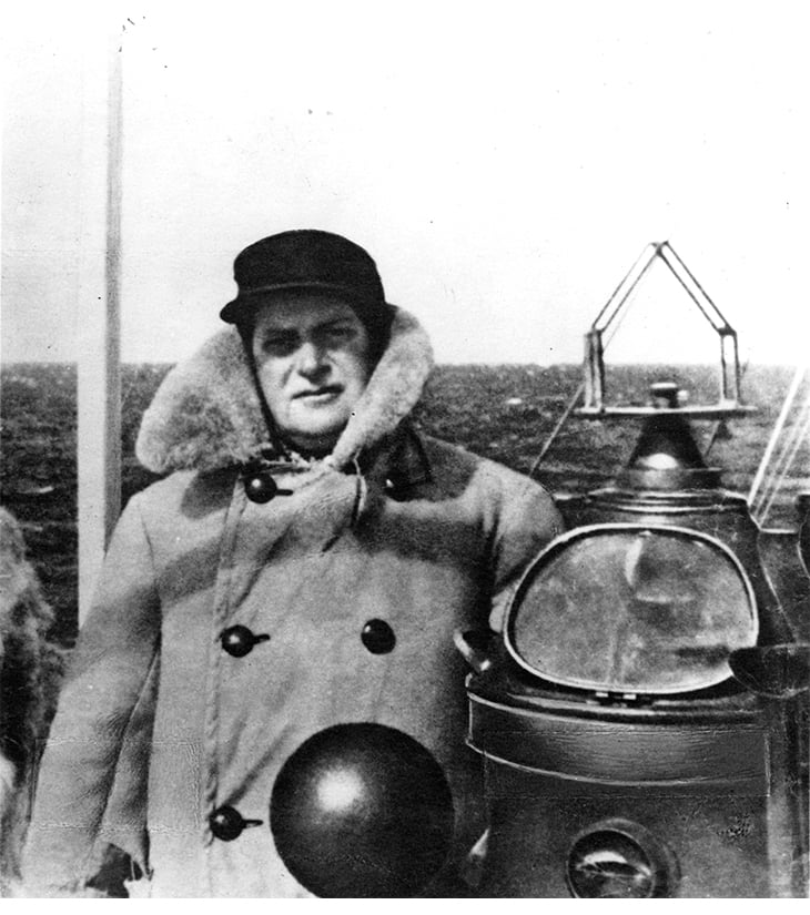
Figure 3.8 Consul Lars Christensen, whaleship owner and nation builder. Christensen financed all the Norwegian scientific expeditions of this period. These activities would underpin Norway’s sovereignty claims.
Photo: Whaling Museum in Sandefjord (Vestfold Museums).
The issue of potential Norwegian annexation of the area between the Falkland Islands Dependencies in the west and the Australian Antarctic Territory to the east was raised with the British Government in a memorandum on 26 January 1934. Notification was provided at the same time that the Norwegian Government might consider holding an international conference to discuss the Antarctic situation, but that it was thought bilateral Norwegian-British talks would be the most practical way to proceed. Among Norway’s objectives in these discussion, was clarification of the maritime boundary issue in the Antarctic. In a note of reply of 23 October 1934, the United Kingdom stated that it agreed with the Norwegian view and indirectly encouraged Norway to proceed with annexation. However, despite the seemingly favourable circumstances, the Norwegian government chose to maintain a policy of reticence for quite some time. That ended abruptly with an incident that dramatically focused Norway’s attention. In December 1938 Adolf Hoel, the polar researcher and head of Norway’s «Svalbard- og Ishavsundersøkelser» (precursor of today’s Norwegian Polar Institute), found out that on 17 December 1938 Germany had dispatched an expedition to the Antarctic. Both the expedition and its purpose were shrouded in secrecy, but the information Hoel had got wind of indicated to him that the object was to claim the same area of the Antarctic that Norway was planning to annex. Hoel immediately notified the Ministry of Foreign Affairs, which agreed that the German expedition’s purpose was in all likelihood to claim land in Norway’s sphere of interest. To avert that situation the government quickly decided to carry out the annexation, which took place by Royal Decree on 14 January 1939. The resolution gave the Ministry of Justice authority to establish regulations for police duties in the area.2
Foreign Minister Koht himself presented his Ministry’s recommendation in support of the Royal Decree, using the following words:
The King approves and signs a submitted draft Royal Order proclaiming that the portion of the mainland shoreline of Antarctica stretching from the border of the Falkland Islands Dependencies in the west (the border of Coats Land) to the border of the Australian Antarctic Dependency in the east (45° eastern longitude), including the land inland from this shore and the ocean abutting it, is to be brought under Norwegian national sovereignty.
This is the area that would later acquire the name Dronning Maud Land.
According to the Norwegian Foreign Ministry, Norway’s right to establish possession of the area was justified on the basis of the geographical exploration Norwegians had independently executed in this area. Norwegian whaling considerations were cited as a reason for Norway to exercise this right. It was also stated expressly that the purpose of the annexation was not to keep other nations out, but to prevent a situation in which Norwegian whaling activities could be excluded or harmed as a result of measures taken by other states.
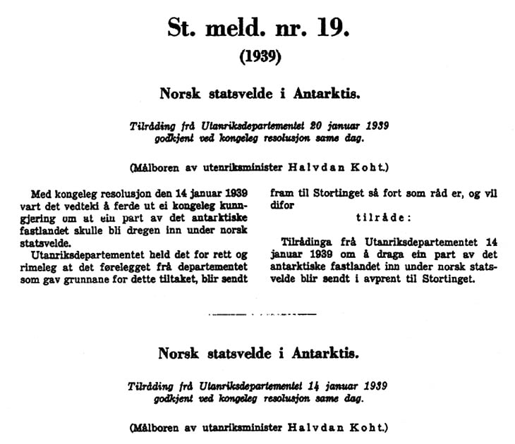
Figure 3.9 Facsimile, excerpt from Report No. 19 (1939) to the Storting, presented by Minister of Foreign Affairs Halvdan Koht.
Textbox 3.4 Dronning Maud Land – the question of its southward geographic extent
Norway made its claim of Dronning Maud Land in 1939, weighing its words carefully. Foreign Minister Koht defined the annexed area as ‘… the mainland shoreline of Antarctica … including the land inland from this shore and the ocean abutting it ...’. With this formulation, Norway underscored that our polar policies rested on the same principles in both the north and the south by indicating that the Norwegian claim in Antarctica did not constitute a sector. Since the early 1900s it had been an important part of Norwegian polar policy to reject the ‘sector principle’, on which a number of States had based claims in both the northern and southern Polar Regions. The wording of the claim was not, however, intended to imply any great difference in practice. It follows from Report No. 19 (1939) to the Storting on Norwegian sovereignty in the Antarctic that the purpose of the annexation was to establish possession of ‘that land which until now has been without rule and which no one other than Norwegians has studied and mapped’. On this basis, Norwegian authorities have not opposed any interpretation of the Norwegian claim as extending all the way to, and including the pole itself.
The contents of the annexation resolution were quickly communicated to most of the countries with which Norway had diplomatic relations. Most of these had no remarks. The United Kingdom – on behalf of the British Commonwealth of Nations – replied accommodatingly on 1 September 1939, and made a generous suggestion, accepted by Norway, that the border of the Norwegian area be set at 20° W longitude.3 Four countries objected to the Norwegian annexation announcement: the United States, Chile, the Soviet Union and Germany.
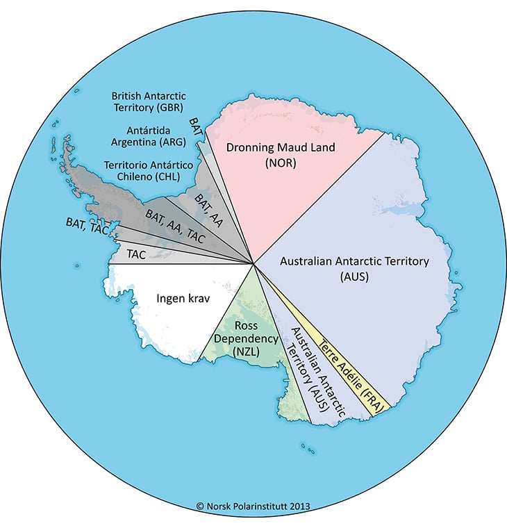
Figure 3.10 Map of the Antarctic, showing claim delimitations.
Source Norwegian Polar Institute.
The Germans rejected the Norwegian claim. In August of 1939, Germany announced the formation of a ‘German Antarctic sector’ between 4° 59’ E and 16° 30’ E longitude. The German claim area, which was given the name Neuschwabenland, lay completely within the area that Norway had already annexed. The German claim never received international approval, and after World War II it was not raised again.
3.1.4 From 14 January 1939 to 21 June 1957: Consideration of Dronning Maud Land’s constitutional status
More than 18 years would pass from Dronning Maud Land’s placement under Norwegian sovereignty until its constitutional status was elucidated and formalised in Norway’s Dependencies Act4 (see Chapter 5, on legislative matters). Part of the reason was the effect of world politics on Norwegian Antarctic policy. Though Norway and the United Kingdom had come to agreement on their claims and borders, other countries clearly held different views on the matter of territorial possessions in the Antarctic. Chile (in 1940) and Argentina (in 1942) had made claims for large areas that were partly in conflict with each other and partly in conflict with the British claim to the Falkland Islands Dependencies. The United States and the Soviet Union, meanwhile, had given notice that they, too, wanted a say in resolving political and legal issues in the Antarctic.
It soon became clear that the United States aspired to play a leading role in this regard. The Americans laid out their plans in a note dated 9 August 1948 to the seven claimant countries (Norway, the United Kingdom, New Zealand, Australia, France, Argentina and Chile). The note proposed that these countries in association with the United States establish joint rule of Antarctica. This proposal for a condominium was given a mixed reception. Norway and several other countries strongly opposed it. In addition, a sharp protest came from the Soviet Union (which had not submitted any sovereignty claims, but considered itself equally entitled to an opinion in the matter). Due to the lack of support, the US proposal was quietly shelved.
Around this time the Norwegian authorities began discussing what actions the country’s new territorial addition required of them. An initial concern was what measures Norway would have to take if other countries advanced new claims in the Antarctic. The leading view was that Norway ought to strengthen its claim by carrying out scientific research in the area, a view that resulted in the Maudheim Expedition of 1949–52.
The matter of formalising the annexed area’s constitutional status had also come up for consideration. At the initiative of the Ministry of Foreign Affairs, the Ministry of Justice issued a set of recommendations on 28 May 1948. It was submitted to the Storting as Proposition No. 70 (1948) to the Odelsting. Among its specific proposals was the naming of ‘Dronning Maud Land’ and the suggestion to apply the Act of 27 February 1930 regarding Bouvetøya and Peter I Øy to the area. But as a consequence of the American note of 9 August 1948, consideration by the Storting was postponed. In 1951 it was postponed again, this time because the Parlimentary Committee on Foreign and Constitutional Affairs believed the issue should not be raised due to the ongoing conflict between the United Kingdom and Argentina over sovereignty in West Antarctica.
For several more years there was no substantive discussion of the constitutional issue. When it re-emerged, it was a result of preparations for the International Geophysical Year (IGY). This scientific event would last from 1 July 1957 to 31 December 1958, with 12 countries, among them Norway, taking part in a variety of expeditions and activities at research stations in the Antarctic interior. To facilitate scientific cooperation and avoid political trouble, the parties agreed informally that nothing should be done in connection with the IGY that would affect Antarctic sovereignty issues.
In Norway, all the same, the pre-IGY activities led to renewed discussion of Dronning Maud Land’s constitutional status. The prevailing view was that it ought to be determined before the opening of the IGY. On 21 June 1957, therefore, a bill amending the Act of 27 February 1930 relating to Bouvetøya and Peter I Øy was sanctioned. With that, Dronning Maud Land – a vast ice-covered area nearly 3 million km2 in extent – received lawful status as a Norwegian dependency. More about this can be found in chapters 5.1 and 5.2.
3.2 History of the treaty system
3.2.1 The Antarctic Treaty and the treaty system
International scientific cooperation associated with the IGY, and the desire to structure it more efficiently, led to the establishment in 1957 of the Special Committee on Antarctic Research (SCAR), whose name would later be changed to the Scientific Committee on Antarctic Research. At the first meeting of SCAR, in February 1958, it became clear that the participating countries planned to continue carrying out their activities in the Antarctic, and even expand some of them. This spurred a development which opened the way for the negotiations that resulted in the Antarctic Treaty, a unique and innovative international agreement that was signed on 1 December 1959 and entered into force on 23 June 1961. The original treaty parties were the same 12 countries that had cooperated during the IGY. These included, in addition to the seven claimant states, the United States, the Soviet Union, Japan, Belgium and South Africa.
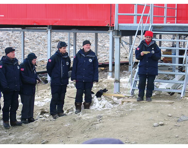
Figure 3.11 The year-round Troll station was officially opened by HM Queen Sonja on 12 February 2005.
It was the United States that took the initiative in the spring of 1958 to negotiate an agreement to ensure that the scientific cooperation begun during the IGY could continue. The Antarctic Treaty established a cooperative multinational regime that marked a new era in that continent’s history. It significantly changed the legal framework for the Antarctic policies of Norway and other countries, and for their activities in the Antarctic. Oversimplifying somewhat, one could say that all the activities undertaken in the Antarctic during this era must be understood in light of the Antarctic Treaty and the regulations and guidelines it contains.
3.2.2 Norwegian activity and policy related to the Antarctic Treaty
Through the 1960s, while other countries were increasing their activities in the Antarctic, Norway was scaling down. The Belgian, Japanese and Soviet research bases in Dronning Maud Land were kept in operation; the Norwegian base, called Norway Station, was turned over to South Africa. Later, the South Africans expanded their activities by adding the new South African National Antarctic Expedition base (SANAE), which was also situated inside the Norwegian dependency. Over the next 15–16 years, Norway sent no scientific expeditions of its own to the Antarctic mainland. But on occasion small groups of Norwegian researchers or individuals took part in expeditions from other countries (such as the United States), or were transported into the area by aircraft from other countries.
In October 1969 the Government of Norway endorsed a memorandum from the Ministry of Industry concluding that Norway should uphold its sovereignty claims in the Antarctic, and that the establishment of a fixed station with a one- or two-year span of operation would have to be considered once more experience was obtained in the joint expeditions with the United States (i.e. American expeditions in which a few Norwegian scientists had participated). This statement was welcomed as the first clarification of Norwegian Antarctic policy since the country’s accession to the Antarctic Treaty, a view reflected in the following newspaper commentary: ‘For the first time a Norwegian government has produced something that could only be termed a declaration of principle regarding what we want and what we intend to do on a longer-term basis on the only foreign continent where we claim a right to any territory.’5 In January 1973 the Government also endorsed a Ministry of Foreign Affairs memo whose conclusion (as in the previous case) was that Norway among other things should hold fast to its sovereignty claims in the Antarctic while supporting an expansion in research cooperation. It has been clear ever since that research activities would play a key role in Norwegian Antarctic policy.
Textbox 3.5 Earlier Norwegian scientific activity
Members of the first Norwegian expeditions to the Antarctic conducted scientific studies on a rather large scale, even though commercial and political motives played a substantial role. The Maudheim Expedition, which overwintered from 1949–52 at 71° 03’ S latitude and 10° 56’ W longitude, inaugurated a new era by putting polar research more in the foreground. This Norwegian-British-Swedish expedition was in its way pioneering, with respect to the level of international research cooperation undertaken, which over time would become such a crucial element in Antarctic development.
As part of its activities related to the International Geophysical Year, Norway was responsible for an Antarctic scientific expedition in 1956–60 which established a research station called Norway Station. This was a wintering station on the Fimbul Ice Shelf at 70° 30’ S latitude and 2° 32’ W longitude. Scientifically speaking, Norway Station was a resounding success. The station was also influential as a demonstration of Norwegian presence in the region. It validated the annexation of Dronning Maud Land and gave Norway an important role in the negotiations that led to the Antarctic Treaty.
3.2.3 A policy of cooperation
In October 1974, when he was asked in the Storting what was being done to protect Norwegian interests in the Antarctic, Foreign Minister Knut Frydenlund pointed to Norway’s cooperative engagement under the Antarctic Treaty. His reply included the following words: ‘It is quite clear that a continuation of the cooperation now taking place is the best way of securing Norway’s interests in these areas.’6 That statement has remained standing as a concise expression of Norwegian Antarctic policy applicable for the long term. Most subsequent official declarations of Norwegian policy related to the Antarctic have highlighted Antarctic Treaty cooperation as a major element in advancing Norwegian interests in the region.
From the 1970s onwards, as research activities gradually attained higher priority in Norwegian Antarctic policy, Norway began to play a more active role in Antarctic Treaty issues related to political cooperation. The country’s role as a bridge-builder between the various actors and interest groups within the treaty organisation was characteristic of Norwegian policy. Also typical was Norway’s strong contribution to the expansion of the Antarctic Treaty System into new policy areas – not least with regard to environmental and resource issues. Norway was active, for example, in developing the Convention for the Conservation of Antarctic Seals (1972) and in negotiating the Convention on the Conservation of Antarctic Marine Living Resources (the CAMLR Convention), which came into force in 1982.
The issue of regulating future exploitation of mineral resources in the Antarctic was first raised by Norway at a special ‘informal’ conference of the Consultative Parties to the Treaty in May 1973. As a result of that conference, which was arranged by a Norwegian organisation called the Fridtjof Nansen Foundation, via a grant from the Ministry of Foreign Affairs, the issue was taken up formally at the next consultative meeting, in Oslo in 1975. With that Norway took leadership of negotiations during the 1980s for a possible agreement to regulate future mineral exploitation (the Convention on the Regulation of Antarctic Mineral Resource Activities, or CRAMRA). When it became clear that CRAMRA would not be ratified, the Consultative Parties to the Treaty – upon an initiative from Norway and including active Norwegian participation – agreed instead on a protocol to the Antarctic Treaty. This Protocol on Environmental Protection to the Antarctic Treaty, signed on 4 October 1991 and brought into force 14 January 1998, designates the Antarctic as a natural reserve devoted to peace and science.
Textbox 3.6 Recent Norwegian scientific activity
The first official NARE Expedition (Norwegian Antarctic Research Expeditions) took place in 1976–77, marking the start of more frequent Norwegian visits to the Antarctic. In the early 1990s, expeditions began to be conducted in close cooperation with other Nordic-Antarctic countries – Finland and Sweden.
In 1989–90, a permanent Norwegian research station was built at Jutulsessen in Gjelsvikfjella, 235 km from the coast at 72° 01’ S latitude and 2° 32’ E longitude. Situated at an elevation of 1,275 m, the station was given the name Troll. In 2004–05, the station was expanded and upgraded to provide year-round service. In connection with the expansion, a 3,000-m-long airstrip was constructed 7 km from the station. The Troll Airfield, as it is called, opened officially on 12 February 2005 in conjunction with HM Queen Sonja’s opening of the year-round Troll research station.
Since the establishment of Troll as an all-year facility, there has been a substantial increase in Norwegian research activity in Antarctica. Much of it has occurred in cooperation with other countries, including several major projects undertaken during the 2007–09 International Polar Year.
The opening of Troll as a modern, year-round platform for scientific work has also led to an extensive upgrade of Norway’s own Antarctic research. The Troll station accommodates research and monitoring activity throughout the year, with equipment for observing meteorological phenomena and ultraviolet radiation levels. It also serves as a field station for glaciology, biology and physics. TrollSat downlinks satellite data relevant to a variety of environmental parameters, and the Norwegian Institute for Air Research’s new observatory monitors mercury, ground-level ozone, aerosols, organic pollutants, hydrocarbons and greenhouse gases.
The Troll station and Troll Airfield have made it possible for Norway to be a driving force for international cooperation in Dronning Maud Land.
Footnotes
While one generally speaks of the British ‘empire’ in the early interwar period, we use the term ‘commonwealth’ in this report with regard to the period after 1931, when the Statute of Westminster gave dominions such as Australia, New Zealand and Canada full autonomy and equal status within the newly organised British Commonwealth of Nations.
No regulations have been issued, so administrative and legal authority rests with the Ministry of Justice and Public Security.
In the Norwegian resolution of 14 January 1939 this border had been defined somewhat more vaguely and more to the east (‘the border of Coats Land’), because the Norwegian exploration activities extended only to about 16° 30' W longitude.
Act of 27 February 1930 No. 3 relating to Bouvetøya, Peter I Øy and Dronning Maud Land (Dependencies Act), with subsequent amendments by the Storting.
‘Norge i Antarktis’ (Norway in the Antarctic), leading article in Aftenposten, 25 October 1969.
Excerpt of the reply by Minister of Foreign Affairs Knut Frydenlund to a question from Erik Gjems-Onstad, a member of the Storting, during the Storting’s question hour on 9 October 1974: ‘What is being done to look after Norway’s interests in Bouvetøya, Peter I Øy and Dronning Maud Land?’