6 Use of the Norwegian Sea and spatial management
The white paper Protecting the Riches of the Sea (Report No. 12 (2001 – 2002) to the Storting) stated that the expected increase in the use of coastal and marine areas will make it difficult to strike a balance between the various user interests and environmental considerations, making spatial planning in marine areas an important tool. A sound and sustainable spatial management regime must be based on knowledge of ecosystems and the impacts of different forms of use. In future, Norway’s sea areas are expected to be more heavily used for value creation such as the production of seafood, offshore energy and mineral extraction, and fisheries, maritime traffic and petroleum activities will continue to be major ocean use sectors.
A comprehensive scientific basis has been compiled for each of the management plans for Norway’s sea areas, and the management plans include a number of general decisions about spatial management. Digital mapping tools are extensively used in the plans to illustrate different types of use and protection of marine areas. A consolidated digital mapping tool is being developed that will simplify further work on the marine management plans and make it more effective, and be an asset in developing an integrated and well-coordinated marine management regime.
The North Sea – Skagerrak management plan (Meld. St. 37 (2012 – 2013)) identified the need for an integrated and easily accessible mapping tool for marine management, and served to initiate the development of such a tool.
Growing awareness of the vital role the oceans will play in food production and other forms of value creation in the future has highlighted the need for integrated, coordinated planning of spatial management and marine protection measures.
The main purpose of marine spatial planning is to ensure sound management of activities in sea areas under national jurisdiction while at the same time protecting marine ecosystems.
The Government’s expert committee on green competitiveness has pointed out that growth in marine industries depends on finding solutions to any conflicts that may arise between different interests. The committee has emphasised that it will be necessary to build further on the marine management plans and the processes for developing them in cooperation between the public administration, the research sector and the business sector.
6.1 Spatial use of the Norwegian Sea
The 2009 management plan described the use of the Norwegian Sea by various sectors, especially petroleum activities, fisheries and maritime transport. The plan also discussed the potential use of areas for the development of renewable energy production, particularly offshore wind power, and pointed to the need to protect the particularly valuable and vulnerable areas.
Expansion of oil and gas activities, a high level of fishing activity and a certain increase in the volume of shipping are the main trends in ocean-based industries in the Norwegian Sea since 2009.
6.1.1 Particularly valuable and vulnerable areas in the Norwegian Sea
One important feature of Norway’s marine management plans is the selection of particularly valuable and vulnerable areas. These are areas that on the basis of scientific assessments have been identified as being of great importance for biodiversity and biological production in the entire management plan area. The areas identified in the Norwegian Sea management plan area are as follows: the Remman archipelago, the Froan archipelago and Sula reef, the Møre, Halten and Sklinna banks, the Iverryggen reef, the Vestfjorden, Jan Mayen and the West Ice, the edge of the continental shelf, the Arctic front and the coastal zone. Knowledge about the seabed in the particularly valuable and vulnerable areas of the Norwegian Sea has been improved, and the value of these areas has been confirmed through the MAREANO programme. The goal of the management plan is to ensure that activities in the particularly valuable and vulnerable areas are conducted in such a way that their ecological functioning and biodiversity are not threatened. The areas are described in more detail in Chapter 3.4. An integrated management regime includes both sustainable use of marine areas and protection of areas of high conservation value.
6.1.2 Spatial overlap between ocean-based industries
The further development of existing industries and the potential for the establishment of new ocean-based industries in the management plan area will increase the need for coordinated spatial management.
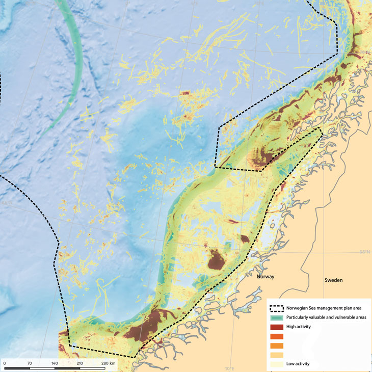
Figure 6.1 Fisheries activity in the Norwegian Sea.
Source Norwegian Environment Agency/BarentsWatch
6.1.3 Fisheries
Overall, there has been little change in fisheries activity in the Norwegian Sea since the 2009 management plan was adopted. The greatest change has been in the mackerel fishery. As a result of a healthy mackerel stock and altered migration patterns and distribution, the Norwegian Sea mackerel fishery has expanded and there have been changes in the areas used by the fisheries. This applies particularly to nearcoast areas northwards to the Vestfjorden and the Lofoten Islands. The fisheries in these areas take place mainly during the summer months. The herring stock has declined, resulting in lower quotas and a declining herring fishery.
Fisheries activity is expected to increase in summer along much of the coast and on the Møre banks. The Møre banks include some of the most important fishing grounds in the Norwegian Sea. The continental shelf is relatively narrow here, and the principal fishing grounds are relatively accessible for the coastal fishing fleet. There is thus some level of activity throughout the year. The main fish stocks harvested in this area are saithe, herring, angler and mackerel. Any changes in mackerel migration patterns will also result in changed patterns of fisheries activity. Some vessels that previously fished for their allocated quotas in the North Sea will spend more and more time fishing in areas north of 62 °N.
Spatial overlap between the fisheries and the petroleum industry is discussed below in the section on oil and gas activities.
No major changes in the level of conflict between the fisheries and maritime traffic are expected, except that there will be larger concentrations of fishing vessels in coastal areas in summer than when the 2009 management plan was published. Under normal circumstances the main conflict of interest between maritime traffic and fisheries is caused by the regular passage of cargo vessels through or very close to fishing grounds where there are concentrations of fishing vessels or fixed fishing gear.
The development of offshore energy or offshore aquaculture could result in spatial overlap with the fishing industry in certain areas that would have implications for the fisheries, especially the coastal fishing fleet.
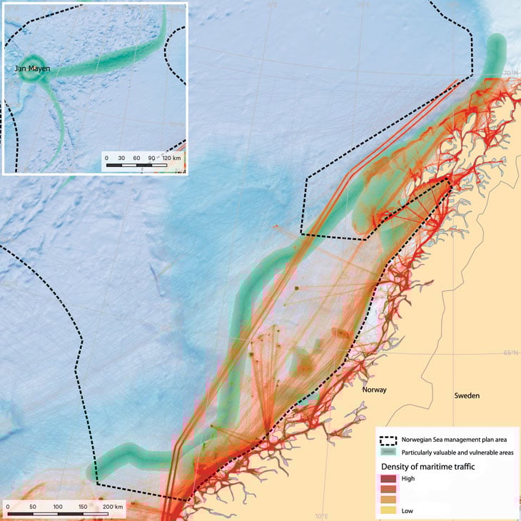
Figure 6.2 Maritime traffic in the Norwegian Sea.
Source Norwegian Environment Agency/BarentsWatch
6.1.4 Maritime traffic
The density of maritime traffic in the Norwegian Sea is generally low. The volume of traffic does not seem to have changed significantly, but total distance sailed rose by 10 % from 2012 to 2015. The introduction of traffic separation schemes and recommended routes between Runde and Utsira, combined with similar schemes for the Vardø – Røst route, has helped to move shipping further out from the coast, separate traffic streams in opposite directions and establish a fixed sailing pattern. Although the traffic separation schemes do not formally apply to the whole of the management plan area, the density plot for maritime traffic shows that they have a clear influence on traffic streams in the Norwegian Sea as well.
In 2011, new traffic separation schemes approved by IMO were introduced for maritime traffic along the coast of Southern and Western Norway. These and the recommended routes lie largely outside territorial waters, which means that some maritime traffic has been rerouted further away from the coast. A traffic separation scheme has also been introduced with a minimum separation zone of two nautical miles between opposite lanes. This reduces the risk of accidents and allows more time to come to the assistance of vessels in difficulties. The schemes apply to all vessels of gross tonnage 5 000 and over and those carrying dangerous or polluting cargo, irrespective of size, in transit along the Norwegian coast or in international traffic to or from a Norwegian port.
International processes are required to establish or alter internationally approved traffic separation schemes outside territorial waters. The system of traffic separation schemes has rerouted some shipping further away from the coast and away from areas with a high level of fishing activity or existing petroleum installations. The new routeing system along the coast has also made traffic patterns more predictable and made it easier to monitor maritime traffic.
Coastal shipping can damage passive fishing gear or cause it to be lost. However, experience has shown that the problem can be reduced if the gear is clearly marked. The aquaculture industry is growing, and occupying more and larger areas along the coast. If nearcoast areas are occupied by for example offshore energy or aquaculture installations, areas may be closed to shipping or traffic may have to be rerouted, which can have negative effects on maritime safety and cause delays. Better coordination and improvements in spatial planning in coastal areas will be required in future.
6.1.5 Oil and gas activities
Within the framework established in the 2009 management plan, production licences for oil and gas may be issued through licensing rounds in areas that have been opened for petroleum activities. Licensing rounds are held every year for mature exploration areas, which are included in the system of awards in predefined areas (APA). For other areas, allocation of licences takes place through numbered licensing rounds that are normally held every second year. The area included in the APA system is being extended in the Norwegian Sea as more of the shelf matures. The level of activity under each production licence depends on the requirements of its work programme and the results of exploration activity.
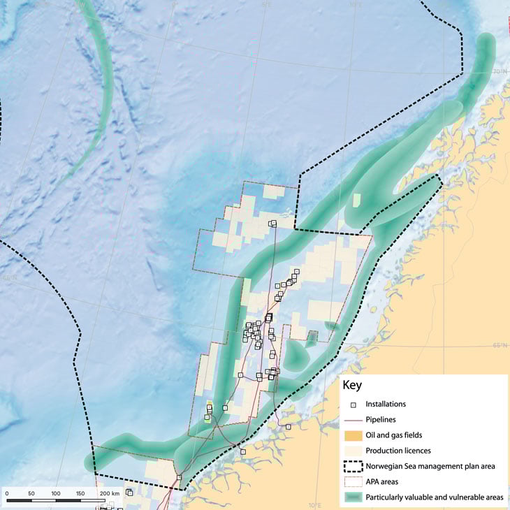
Figure 6.3 Oil and gas activities in the Norwegian Sea.
Source Norwegian Environment Agency/BarentsWatch
Conflicts of interest between the petroleum industry and other industries are mainly caused by spatial overlap between industries, especially certain fisheries. Much of the maritime traffic in the management plan area is related to oil and gas activities.
No significant changes are expected to occur in petroleum activity in the Norwegian Sea up to 2025. The areas used are those covered by exploration or production licences, including oil and gas fields, pipelines, surface installations and areas required for time-limited activities such as exploration drilling and seismic surveying.
Seismic surveys are an essential basis for oil and gas activities. However, seismic activity may have negative consequences for the fisheries if there is competition for the same area and because seismic activity can frighten away fish. Conflicts of interest related to the occupation of areas during seismic surveys are most likely to arise with fishing vessels that have a limited range and during seasonal fisheries with short fishing seasons. Thus, in some circumstances seismic surveys can affect the size of harvests and the income from fisheries.
Delaying seismic surveys can be extremely costly for the petroleum industry. The fisheries also derive benefits from the oil and gas industry, for example through the emergency preparedness and response system.
A number of steps have been taken in recent years to reduce the potential for conflict between seismic surveying and fisheries. In 2013 the then Ministry of Fisheries and Coastal Affairs and the Ministry of Petroleum and Energy published guidelines to promote greater understanding between the parties and clarify which rules and procedures are applicable. Other measures such as improving the training of fisheries experts on board seismic vessels have resulted in a better dialogue between the parties and a reduction in the level of conflict. The extent of seismic surveys has been considerably reduced over the last two years, but some conflicts have still occurred.
6.1.6 Offshore renewable energy production
There are no offshore energy installations in the Norwegian Sea. The Norwegian Water Resources and Energy Directorate has coordinated assessments to identify options for and the likely impacts of opening certain sea areas for offshore renewable energy production. In the strategic environmental assessment that was carried out, areas that had been identified as suitable for offshore wind power were classified into three groups according to their technical and economic feasibility and the impacts of their development on other user interests in the same area. The areas identified in the Norwegian Sea are not included in the group that the Directorate recommends should be given priority. The Government intends to clarify which areas should be opened for licence applications.
The areas in the Norwegian Sea that are considered suitable for offshore wind power are Stadhavet, Frøyabanken, Nordøyan – Ytre Vikna, Træna West and Trænafjorden – Selvær. Potential conflicts of interest are described in the strategic environmental assessment.
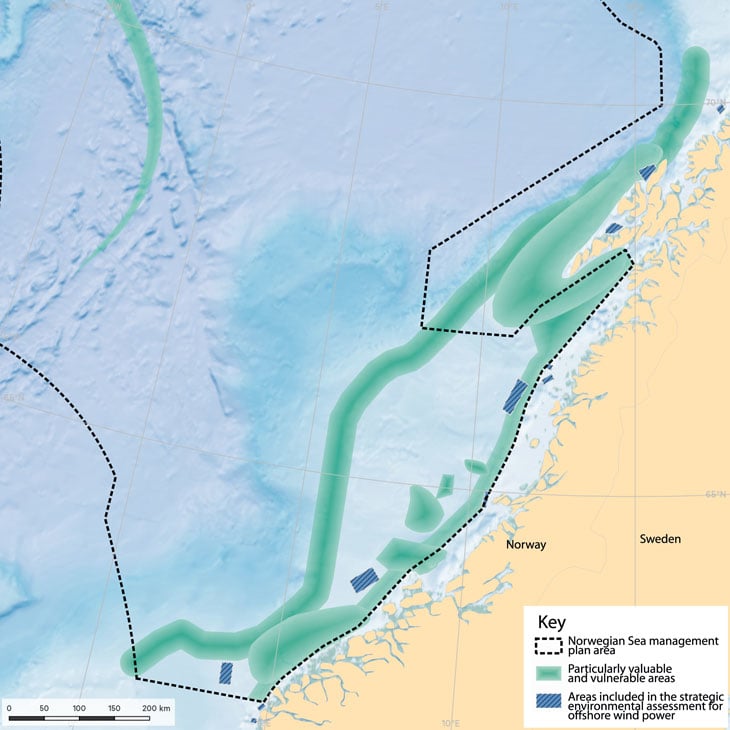
Figure 6.4 Areas included in the strategic environmental assessment for offshore wind power in the Norwegian Sea.
Source Norwegian Environment Agency
Offshore wind farms cover substantial areas, and there may be conflicts of interest with fisheries and maritime traffic. According to the strategic environmental assessment, there is a possibility of conflicts of interest with other users in all the assessed areas, and opening these areas for wind power would affect environmental, commercial and other public interests.
6.2 Marine protected areas
Marine protected areas under the Nature Diversity Act may be established in Norway’s territorial waters, which extend up to 12 nautical miles beyond the baseline. The Government’s policy is that cross-sectoral marine protection efforts under section 39 of the Act will be continued in order to ensure that a selection of representative, distinctive or threatened underwater habitats along the coast and in territorial waters is safeguarded for future generations. The objective is for these areas, together with areas safeguarded under other legislation, to form a network of protected areas that will safeguard ecosystems, habitats and species.
In addition to the areas that are protected under the Nature Diversity Act, there are many areas that are protected against various types of fishing activities under fisheries legislation. For example, a number of areas are protected against the use of fishing gear and techniques that can damage coral reefs. Marine protected areas under the Marine Resources Act may be established in all Norwegian sea areas and the Norwegian continental shelf.
Under the Convention on Biological Diversity there is a target that by 2020, 10 % of coastal and marine areas, especially areas of particular importance for biodiversity and ecosystem services, will be conserved through effectively and equitably managed, ecologically representative and well-connected systems of protected areas and other effective area-based conservation measures. Norwegian implementation of the international target for conservation of coastal and marine areas was discussed in the white paper on Norway’s national biodiversity action plan and the subsequent debate in the Storting.
Efforts to safeguard marine areas and their species and habitat diversity for the future have been in progress for a long time. In 2004 a broad-based advisory committee identified 36 marine areas along the coast that are being evaluated as part of these efforts (see Table 6.1). The marine protected areas that have so far been established in the coastal waters and fjords of the Norwegian Sea are Saltstraumen, Tauterryggen, Rødberget and Gaulosen. Six marine protected areas within the management plan area have been established to protect cold-water coral reefs from being damaged by fisheries activities: Aktivneset, Breisunddjupet, Storneset, and the Sula, Iverryggen and Træna reefs.
Table 6.1 Areas proposed for inclusion in Norway’s marine protected plan by the advisory committee and their current status
County | Area | Status |
|---|---|---|
North Sea – Skagerrak | ||
Østfold | Østfold (Rauøyfjorden) | Ongoing protection process |
Aust-Agder | Skagerrak transect | Protected in 2016 as part of Raet National Park |
Vest-Agder | Framvaren | Protected in 2013 |
Rogaland | Jærkysten | Protected in 2016 |
Hordaland | Ytre Hardangerfjord | Ongoing protection process |
Lurefjorden with Lindåspollene | Ongoing protection process | |
Korsfjorden | Ongoing protection process | |
Sogn og Fjordane | Sognefjorden | Process not yet started |
Dalsfjorden | Process not yet started | |
Norwegian Sea | ||
Stad | Process not yet started | |
Møre og Romsdal | Giske | Process not yet started |
Griphølen | Process not yet started | |
Remman archipelago | Process not yet started, but some parts are already a nature reserve | |
Sør-Trøndelag | Gaulosen | Protected in 2016 |
Rødberg | Protected in 2016 | |
Froan archipelago and Sula reef | Process not yet started | |
Grandefjæra etc. | Process not yet started | |
Nord-Trøndelag | Tauterryggen | Protected in 2013 |
Børgin | Ongoing protection process | |
Skarnsundet | Ongoing protection process | |
Borgan-Frelsøy | Process not yet started | |
Nordland | Saltstraumen | Protected in 2013 |
Vistenfjorden | Ongoing protection process | |
Nordfjorden (Rødøy municipality) | Ongoing protection process | |
Karlsøyvær | Ongoing protection process | |
Kaldvågfjorden and Innhavet | Ongoing protection process | |
Tysfjorden | Process not yet started | |
Barents Sea – Lofoten | ||
Nordland/ Troms | Andfjorden transect | Process not yet started |
Troms | Rossfjordstraumen | Ongoing protection process |
Rystraumen | Ongoing protection process | |
Ytre Karlsøy | Ongoing protection process | |
Finnmark | Lopphavet | Ongoing protection process |
Indre Porsangerfjord | Process not yet started | |
Tanafjorden transect | Process not yet started | |
Marine areas outside territorial waters | Iverryggen reef | Protected under the Marine Resources Act |
Røstrevet reef | Protected under the Marine Resources Act |
Source Norwegian Environment Agency/Ministry of Climate and Environment
A plan for establishing more marine protected areas is being developed. As part of this work, the status of efforts to establish marine protected areas will be evaluated, and any further need for protection to achieve national and international targets will be identified. The findings will form part of the basis for further marine protection efforts both in Norway’s territorial waters and outside the 12-nautical-mile limit. Under the management plans for Norway’s sea areas, regular assessments of the need for new measures to protect marine species and habitats will be conducted on the basis of existing knowledge.
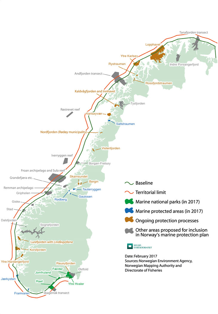
Figure 6.5 Status of areas proposed for inclusion in Norway’s marine protection plan.
Source Norwegian Environment Agency
6.3 Digital mapping tool for Norway’s marine areas – better access to digital maps
The overall body of spatial data already available for the Norwegian Sea includes data on various themes, such as species and habitats and industrial activities, and information on the spatial frameworks for conservation and sustainable use in the management plan area and adjoining coastal areas.
Key themes for which spatial data are available today, and that need to be considered together, include environmental information, particularly valuable species and habitats, fisheries, maritime traffic and recommended routes, oil and gas activities, pipelines and cables, renewable energy production such as offshore wind power, and marine protected areas.
The future development of ocean-based industries and the introduction of new management measures in Norway’s marine areas must be based on updated knowledge and information about species and habitats and about activities in different sea areas. Reliable and readily available spatial data are therefore essential for the development of potential or emerging activities like mineral extraction, marine bioprospecting, offshore aquaculture and new fisheries. At present it is difficult to estimate the likely scale of such new activities in the Norwegian Sea.
The first version of a digital mapping tool for Norway’s sea areas has been developed, which is designed to provide integrated information in mapped form on industrial activities, species and habitats, and regulatory measures.
The consolidated digital mapping tool will be a useful tool for the authorities, the business sector, interest organisations, other users of the sea areas and the general public. The initial stages of work on the mapping tool are described in the North Sea – Skagerrak management plan.
The mapping tool will provide a better overview of decisions and measures relating to Norway’s sea areas, both those that are part of the management plan system and those linked to sectoral processes. Spatial data on the content of the scientific basis for the management plans and on developments in marine areas will also be more readily accessible. In addition, the mapping tool will make the management plan process more inclusive process by increasing transparency, and strengthen stakeholder participation in the work on the management plans.
Better access to spatial data will also be useful in meeting needs not related to the management plans, such as the need for integrated information on specific geographical areas.
The digital mapping tool is being developed in close cooperation between the Forum for Integrated Marine Management and BarentsWatch, and is available via the website www.barentswatch.no.
6.4 Knowledge about Norwegian sea areas – mapping of the seabed by the MAREANO programme
The MAREANO programme was begun in 2005 to satisfy the need for more knowledge of conditions on the seabed in Norwegian waters. The programme has provided valuable information through mapping of depth and topography, species diversity, habitat types, chemical conditions and pollutants in sediments, and geological formations on the seabed. Data from the MAREANO surveys are made available on the programme’s website and through the Norway Digital programme. In 2016 the International Council for the Exploration of the Sea carried out a technical review of the scientific methodologies used in the MAREANO programme. The review concluded that overall the programme meets high scientific standards and uses sound scientific methods. It also recommended ways of further improving the quality of the programme, which will be followed up.
Mapping of the seabed generates a great deal of new information on the distribution of habitats and species and the pressures and impacts associated with human activity. The information can be used to improve the management regime and provide better protection for vulnerable habitat types. Priority is being given to areas where there are or may be important species and habitat types or natural resources that could be affected by existing or new human activities. In the process of developing the scientific basis for the marine management plans, data obtained through MAREANO has confirmed the environmental value of the areas identified as particularly valuable and vulnerable.
The MAREANO programme has mapped many new coral reefs. As a result of the new information, ten new areas of cold-water coral reefs in Norwegian waters have been given special protection by designation as marine protected areas under section 19 of the Marine Resources Act. Knowledge acquired through the MAREANO programme is an important basis for sustainable management of the seabed, for example by adding to the knowledge base on vulnerable habitat types such as corals and sponge communities, and reduces the risk of damage to such habitats during fisheries and other activities. Coral reefs and other valuable species and habitats outside the 12-nautical-mile limit have to be protected under existing sectoral legislation.
Knowledge is also needed to ensure a representative selection and ecological coherence when areas in Norwegian waters are protected, and the information gathered through the MAREANO programme is an important part of the knowledge base.