2 Extent and delimitation of the airspace

Illustration: ESA / D. Ducros
The airspace is a part of Norway’s territory in the same manner as the mainland territory and territorial waters. It is an alternative transport route to maritime and mainland transport but also the basis for other important functions in society. Sovereignty and the Norwegian right to exercise control are therefore just as important in the airspace as on the mainland and in territorial waters. In order to be able to administer this territory in a sound manner, an important starting point is to be aware of the geographical boundaries of the airspace.
2.1 Delimitation of the airspace in relation to outer space and the mainland
The conventional airspace, i.e., the airspace in the direction of outer space, is subject to regulation by states, by the Chicago Convention on International Civil Aviation and the International Civil Aviation Organization (ICAO), as well as regulations issued by the EU, cf. Chapter 5. States have sovereignty over their airspace and can, in principle, administer this space as a national resource. Efforts are currently underway in international bodies to regulate the use of outer space, including the delimitation of conventional airspace and outer space. The question was recently discussed in relation to Norwegian law in the Norwegian Government’s National Space Strategy, Meld. St. 10 (Report to the Storting (white paper)) (2019–2020) Høytflyvende satellitter – jordnære formål – en strategi for norsk romvirksomhet [High-flying satellites - down-to-earth purposes – a strategy for Norwegian space activities], as well as in the report Rett i bane [Into Orbit] by a law committee appointed by the Ministry of Trade, Industry and Fisheries to propose a new Act relating to activity in outer space (the Norwegian Space Law Committee).
The Space Law Committee highlighted the disagreements regarding a definition of outer space under international law and believes that Norway should await the international efforts on a possible multilaterally embedded definition. The Committee also believes there may be grounds for claiming that the boundary for outer space is not lower than 80km and not higher than 110km. This ambiguity in international law thereby relates to an area of approximately 30km. In the absence of an established boundary, it must be determined on a discretionary basis.
Even though there is currently limited activity in this area, the developments in aviation and space activities indicate that the level of activity will increase. For the activities in the border areas between conventional space and outer space, it will be necessary to distinguish between activities that, by their nature, are aviation, and activities that should be regulated by a new act relating to activities in outer space. More detailed guidelines regarding these delimitations will have to consider the authorities’ ongoing and future regulatory efforts. Furthermore, by defining “activity”, e.g., aviation activity, one can also define the scope of the act and establish the boundaries for a given type of activity.
The problems relating to the use of the upper parts of the airspace, e.g., the border areas between conventional airspace and outer space (Higher airspace operations and High altitude operations) are addressed in ICAO’s Resolution A40-71 and domestically. It is important that Norway continues to pay close attention to these efforts and remains engaged in all relevant fora.
Airspace use requires interaction with and permission from the Civil Aviation Authority of Norway. Andøya Space launches rockets and balloons on a regular basis and needs to consider the conventional airspace and outer space in the same operation.
Regarding the use of the airspace near ground level, it is undisputed that states can regulate the airspace above their territories down to the mainland or the ocean surface.
2.2 Horizontal delimitation of the airspace
The geographical scope of the airspace, understood as the extent and delimitation horizontally, is, in principle, fixed as it follows the delimitation of Norwegian mainland territory and the territorial waters.
Norwegian airspace above Norwegian territorial waters is delimited and extends to the territorial boundary of 12 nautical miles from the baseline. Beyond this boundary, international regulations apply, including ICAO’s standards and recommendations.
In Meld. St. 9 (Report to the Storting (white paper)) (2020–2021) Mennesker, muligheter og norske interesser i nord [People, opportunities and Norwegian interests in the north] , the Norwegian Government’s policies for the High North for the forthcoming years are presented. Therein, the Norwegian Government defines the High North as Norway’s most important strategic area of responsibility, while High North policy covers the international situation in the Arctic, the relationships with our neighbouring countries in the Barents Region and the Cap of the North, as well as the developments in Northern Norway. On this basis, flights and other uses of the airspace in the High North and Arctic areas will be a natural part of the strategic assessments regarding the framework for use of the airspace. However, there may be a need for more detailed clarification of what legal possibilities we have in the airspace above the parts of the High North that are outside of Norwegian territory.
2.3 Norway’s obligations in relation to ICAO
Under the auspices of ICAO, a global division of the international airspace has been undertaken (over the high seas) where air navigation services are provided2. Norway has accepted the duty to provide air navigation services in certain parts of this airspace, cf. the figures below. Mainland Norway and southern parts of the Norway’s exclusive economic zone are located in the European region (EUR), whereas e.g., Svalbard and larger parts of Norway’s exclusive economic zone are located in the North Atlantic Region (NAT). NAT is divided in to seven flight information regions (FIR), where Bodø Oceanic FIR is the easternmost region. In the Bodø Oceanic FIR, Norway provides air navigation services from the control centre in Bodø.
Svalbard is located in the Bodø Oceanic FIR, where Norway provides air navigation services.
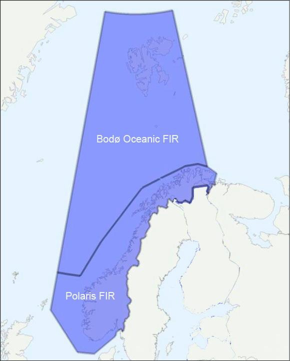
Figure 2.1 Flight information regions (FIR) where Norway provides air navigation services
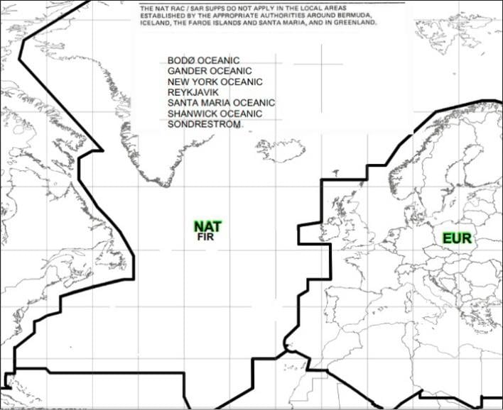
Figure 2.2 ICAO’s regional divisions – NAT and EUR
2.4 Strategy
The Norwegian Government will:
- Actively participate to promote Norwegian interests in international fora regarding the delimitation of conventional airspace and outer space, and flights in the border areas between conventional airspace and outer space.
- Actively participate in promoting Norwegian interests relating to the High North in international fora.