10 Measures for the conservation and sustainable use of the ecosystems of the Norwegian Sea
The state of the Norwegian Sea environment is generally good. However, management of the area poses considerable challenges, particularly as regards the impacts of climate change and ocean acidification, overfishing of certain fish stocks, the risk of acute pollution, the decline of seabird populations and the need to protect coral habitats. The Government considers it important to safeguard the ecosystems of the Norwegian Sea in the long term, so that they continue to be clean, rich and productive. The present integrated, ecosystem-based management plan will serve as a basis for these efforts.
In the implementation of the management plan, the Government will seek to ensure that the Norwegian Sea is managed through conservation and sustainable use, in accordance with the goals set out in Chapters 2 and 9. Furthermore, the management regime is to be based on national goals, the precautionary principle and the principle that cumulative environmental effects must be assessed. The management regime for the Norwegian Sea is to be knowledge-based.
10.1 Spatial management
Eleven particularly valuable and vulnerable areas have been identified in the Norwegian Sea (see Chapter 3.3). They were identified as particularly valuable on the basis of the ecological goods and services they provide, which vary in their vulnerability to anthropogenic pressures. The Government emphasises that particularly valuable and vulnerable areas should be managed with special care. This means that special importance must be attached to knowledge development and environmental impact assessment, and that a cautious approach must be taken to activities in such areas.
The Nature Management Act introduces provisions on selected habitat types. The habitat types to which these apply will be determined in regulations under the Act. The provisions on selected habitat types are intended to safeguard endangered and vulnerable habitats through sustainable use. The authorities will continue to apply sectoral legislation to the designated habitat types, but they will be required to take particular account of the possible impacts of activities on such habitat types, and procedures will be better coordinated.
10.1.1 Protection of coral reefs and other marine habitats
Very little is known about seabed habitats in the Norwegian Sea, and we have little information about where there are vulnerable areas. This makes it particularly important to apply the precautionary principle to management of the Norwegian Sea. In accordance with the target of halting the loss of biodiversity by 2010, the Government will work towards the protection of coral reefs, gorgonian forests and other vulnerable habitat types. A public consultation is currently being held on a proposal for special protection of a further three areas. These are an area called «Korallen» north-west of Sørøya island in Finnmark, the Træna reefs off the Lofoten Islands and an area called «Breisunddjupet» off Ålesund. The latter two are within the present management plan area.
The Norwegian Biodiversity Information Centre plans to publish a Norwegian Red List of endangered and vulnerable habitat types in 2009. If the list classifies marine habitat types in the Norwegian Sea other than coral habitats as endangered or vulnerable, the need for special protection measures will be considered for these as well.
Seabed surveys under the MAREANO programme will improve our knowledge of the distribution of habitat types and provide a basis for better protection of vulnerable habitat types. As regards kelp forests, it is particularly important to develop an integrated management regime and gain a better understanding of overgrazing by sea urchins.
The Government will:
continue the MAREANO programme;
map known coral habitats so that they can be more effectively protected against damage from fishing operations under existing legislation;
lay down strict requirements for demersal fisheries and reporting requirements for such fisheries in order to avoid damage to benthic habitats;
step up efforts to further develop bottom gear to minimise impacts on the seabed;
introduce restrictions on the use of gill nets and longlines in all coral habitats that are already protected against the use of bottom gear;
complete the preparation of regional regulations relating to seaweed and kelp in Møre og Romsdal in the course of 2009;
in 2010, present a national action plan for protection of coral reefs and other vulnerable seabed habitats;
consider bottom trawl fisheries in areas that have not previously been trawled to be experimental fisheries. Such fisheries must follow restrictive rules including requirements to report any bycatches of corals, sponges, etc. The fisheries and coastal authorities will systematically review the data they receive and assess whether continued fishing in these areas is to be permitted. Information concerning experimental fisheries is to be made available to the environmental authorities. The environmental authorities will also take part in the development of the legislation and in regular reviews of the data reported;
regularly consider whether coral reefs in the management plan area that have been mapped should be given special protection against damage from fishing operations;
not permit drilling in coral reef areas or discharges of drill cuttings in areas where scientific opinion indicates that there is a high probability of damage to coral reefs;
in areas where the benthic fauna is vulnerable or that are key spawning areas for bottom-spawning fish, require the use of technology for dealing with drill cuttings and drilling mud to prevent sediment deposition.
10.1.2 Marine protected areas
Norway has adopted the goal of establishing an international network of Marine Protected Areas (MPAs) in accordance with decisions to achieve this by 2010 under the OSPAR Convention on the protection of the marine environment of the North-East Atlantic and by 2012 under the Convention on Biological Diversity (CBD). Norway’s contribution will be to establish an ecologically coherent national network of well-managed MPAs. Under Norwegian fisheries legislation, protective measures have been implemented both in the form of prohibitions on fishing in specific areas in annual fisheries regulations and in the form of more permanent restrictions. The areas that are to be included in the national marine protection plan will be an important contribution to the network of Marine Protected Areas.
The process of developing Norway’s national marine protection plan is further described in Chapter 7.2.
The Government will:
start the formal planning process for a national marine protection plan in 2009. This means that an evaluation of the various proposals for protected areas will be started, but no prior conclusions have been drawn on which areas to include. The following will be used as a basis for the process:
any spatial and general restrictions on petroleum activities in areas more than 12 nautical miles from the baseline are to be set out in the management plans for Norway’s sea areas and not modified during the process of selecting areas for protection under the marine protection plan;
outside the 12-nautical-mile limit, legislation may be used to restrict all forms of use and activities except petroleum activities in areas selected for inclusion in the marine protection plan;
for areas within 12-nautical-mile limit, protection under the Nature Conservation Act/Nature Management Act and/or relevant sectoral legislation will be considered;
the 17 areas that will be considered for inclusion in the marine protection plan initially are as follows: Skagerrak transect, Framvaren, Jærkysten, Gaulosen, Rødberg, Skarnsundet, Tautraryggen, Borgenfjorden, Vistenfjorden, Nordfjorden (Rødøy municipality), Saltstraumen, Karlsøyvær, Ytre Karlsøy, Kaldvågfjorden and Innhavet, Rossfjordstraumen, Rystraumen, and Lopphavet. The Government has not drawn prior conclusions on protection of these areas.
10.1.3 Framework for petroleum activities
Petroleum activities are already in progress or planned in large areas of the Norwegian Sea, and must be organised in such a way that they can coexist with the fisheries and comply with general environmental requirements. Comprehensive legislation has been established to ensure this. The oil and gas industry has had to meet specific requirements and has implemented a wide range of measures to ensure that fisheries interests and environmental concerns are taken adequately into account, for instance as regards discharges of produced water. Nevertheless, ecological goods and services in some areas require special protection.
Vulnerability to oil pollution varies between the areas that have been identified as particularly valuable.
The Møre banks, Halten bank, Iverryggen reef and Sklinna bank are important spawning grounds, particularly for herring; the Vestfjorden is particularly important as a spawning area for Northeast Arctic cod. Fish eggs and larvae are highly vulnerable to oil pollution.
There are large numbers of seabirds and coastal seals all along the coastal zone including the Froan archipelago, in the Vestfjorden, and around Jan Mayen. They are highly vulnerable to oil pollution, either all year round or at certain times of year or particular stages of their life cycle. Large numbers of seabirds may also congregate on herring spawning grounds on the shallow bank areas and in nutrient-rich areas along the edge of the continental shelf.
There are particularly valuable benthic habitats (corals, kelp forests, and probably other valuable benthic communities) in the following areas: the Remman archipelago, the Sula reef, the Iverryggen reef and the edge of the continental shelf. These areas are considered to be particularly vulnerable to physical disturbance of the seabed.
On the basis of an overall evaluation of the particularly valuable and vulnerable areas that have been identified (see the descriptions above and in Chapter 3), the risk of acute oil pollution and the possible environmental impacts of accidents, and the social benefits of petroleum activities, the Government has decided to establish the following framework for petroleum activities in the Norwegian Sea:
The Møre banks
No blocks will be announced in this area before the first update of the management plan, in 2014 at the latest. The Government will then consider the issue again. This does not apply to the parts of the Møre banks that are included in the system of awards in predefined areas (APA).
The Government will build up knowledge of the impacts of oil spills on fish stocks. There is currently scientific disagreement about the extent of losses and the likely importance of the loss of fish eggs and larvae from a year class for later stock recruitment. The Government will reconsider the question of petroleum activities on the Møre banks when more information is available.
Delimitation of the area – blocks/parts of blocks (parts of blocks shown in italics): 6304/ 12; 6305/ 12; 6306/ 7,8,9,10,11,12; 6307/ 7,8,10,11; 6204/ 2,3,4,5,6, 7,8,9, 11, 12; 6205/1,2,3,4,5,6, 7,8; 6206/1,2,3,4.
Halten bank, open part
No exploration drilling in oil-bearing formations in the spawning season (1 February–1 June).
No seismic surveys during spawning migration/in the spawning season (1 January–1 May).
Use of technology to deal with drill cuttings and drilling mud on herring spawning grounds.
Given the risk-based approach of the health, safety and environment legislation, stricter requirements will apply in vulnerable areas to avoid damage.
Delimitation of the area – parts of blocks: 6408/ 4,7.
Sklinna bank, open part
No exploration drilling in oil-bearing formations in the spawning season (1 February–1 June).
No seismic surveys during spawning migration/in the spawning season (1 January–1 May).
Use of technology to deal with drill cuttings and drilling mud on herring spawning grounds.
Special steps to strengthen the oil spill emergency response system, including short response times.
Given the risk-based approach of the health, safety and environment legislation, stricter requirements will apply in vulnerable areas to avoid damage.
Delimitation of the area – parts of blocks: 6509/ 9,12 and 6510/ 7,10.
Coastal zone, northern part
No steps will be taken at present to initiate opening of areas of the coastal zone that are not currently open for petroleum activities. When the management plan for the Barents Sea–Lofoten area is updated in 2010, the Government will consider whether to initiate opening of these areas for petroleum activities; this process would also include an environmental impact assessment.
Remman archipelago and coastal zone, southern part
No exploration drilling in oil-bearing formations in the spawning season and breeding and moulting seasons (1 March–31 August).
Special steps to strengthen the oil spill emergency response system, including short response times.
Given the risk-based approach of the health, safety and environment legislation, stricter requirements will apply in vulnerable areas to avoid damage.
Delimitation of the area – blocks/parts of blocks: 6307/ 2,3,4,5,6, 7,8,9;6308/ 1,2,4; 6204/ 11, 12; 6205/ 7,10.
Entrance to the Vestfjorden, open part
No blocks will be awarded in this area in the 20th licensing round. If blocks are awarded in later rounds, the following requirements will apply:
No exploration drilling in oil-bearing formations in the spawning season (1 February–1 June);
No exploration drilling in oil-bearing formations in the breeding and moulting seasons (1 March–31 August);
No seismic surveys during spawning migration/in the spawning season (1 January–1 May);
Special steps to strengthen the oil spill emergency response system, including short response times;
Given the risk-based approach of the health, safety and environment legislation, stricter requirements will apply in vulnerable areas to avoid damage.
Delimitation of the area – blocks: 6609/1, 2, 3 and 6610/1, 2, 3, 6611/1, 2.
The Iverryggen reef
In the parts of the Iverryggen reef area that are currently open for petroleum activities, no blocks will be announced before the first update of the management plan, in 2014 at the latest. The Government will then consider the issue again. In its evaluation, the Government will attach importance to new knowledge that has been gained about the area.
Delimitation of the area – parts of blocks: 6509/ 10,11.
Froan archipelago/Sula reef
In the parts of the Froan archipelago/Sula reef area that are currently open for petroleum activities, no new blocks will be announced before the first update of the management plan, in 2014 at the latest. This does not apply to the parts of the area that are included in the APA system. The Government will reconsider the question of petroleum activities in connection with the first update of the management plan. In its evaluation, the Government will attach importance to new knowledge that has been gained about the area.
Delimitation of the area – blocks/parts of blocks: 6408/ 7,10,11,12; 6409/10; 6307/ 2,3; 6308/ 1,2,3.
The edge of the continental shelf
Special importance will be attached to the following two points:
New production licences must include requirements for surveys to identify any coral reefs or other valuable benthic communities that may be affected by petroleum activities and ensure that they are not damaged. Special conditions may be included in licences to avoid damage;
Given the risk-based approach of the health, safety and environment legislation, stricter requirements will apply in vulnerable areas to avoid damage.
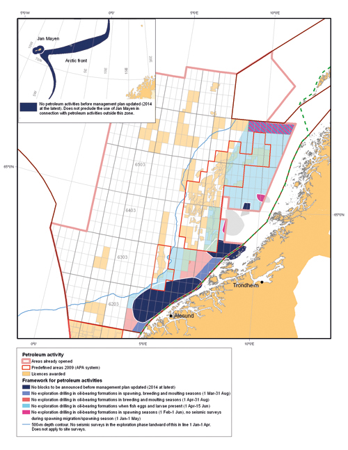
Figure 10-1.EPS Framework for petroleum activities (announcement of blocks, exploration drilling, seismic surveying)
Source Ministry of the Environment
Jan Mayen/the West Ice
The Government intends to initiate opening of the Norwegian part of the shelf around Jan Mayen with a view to awarding licences. The first step is to further investigate the petroleum resources and ecological goods and services of the area and to carry out an environmental impact assessment of opening the area for petroleum activities. The Government will use the conclusions of this impact assessment as a basis for determining the framework for petroleum activities.
However, before the first update of the management plan, in 2014 at the latest, no petroleum activities will be permitted in a zone stretching 30 km outwards from Jan Mayen. This does not preclude the use of Jan Mayen in connection with petroleum activities outside this zone. In connection with the first update of the management plan, the Government will reconsider the question of petroleum activities close to Jan Mayen. In its evaluation, the Government will attach importance to new knowledge that has been gained about the area.
There may also be mineral resources other than petroleum in this area. This management plan does not involve any restrictions on exploration and extraction of such resources.
The arctic front
The Government does not propose to open any areas within the arctic front for petroleum activities at present. The Government will consider this issue again in connection with the first update of the management plan, in 2014 at the latest.
Other areas that have been opened for petroleum activities in the Norwegian Sea
The environmental and fisheries-related requirements in licences for parts of the Norwegian Sea not discussed above have also been reviewed. In these areas, the current requirements will generally continue to apply, including those laid down in the 20th licensing round. Until the first update of the management plan, in 2014 at the latest, the following environmental and fisheries-related requirements will apply to new licences in these areas:
No seismic surveys in the exploration phase to be carried out landward of the 500-metre depth contour in the period 1 January–1 April. This restriction does not apply to site surveys;
No exploration drilling in oil-bearing formations when fish eggs and larvae are present (1 April–15 June) in the blocks 6204/ 1,2,3,4,5,7, 8 and 6304/ 12 landward of the 500-metre depth contour; quadrant 6305 landward of the 500-metre depth contour, quadrants 6306, 6307, 6407/2,3,5,6,8,9,11,12; 6408/ 4,7; 6508, 6509, 6510, 6608/ 3,5,6,7,8,9, 10,11,12; 6609, 6610 and 6611;
No exploration drilling in oil-bearing formations in the breeding and moulting seasons (1 April–31 August) in the blocks 6204/ 7,8,10, 11;6306/6, 8,9;6307/1, 2,3,4,5,7.
No further environmental and fisheries-related requirements for petroleum activities in these areas will be included in licensing rounds (including APA rounds) before the first update of the management plan, in 2014 at the latest.
The authorities will take a flexible approach to the environmental and fisheries-related requirements.
On application, the environmental and fisheries-related requirements that are included in new licences may also be made applicable to existing licences for these areas.
Updating and revision of the management plan
The management plan will be a rolling plan and will be updated at regular intervals. The first update will be made at the latest in 2014. At this point, the Government will also conduct a new assessment of the spatial framework for petroleum activities in the Norwegian Sea. On the basis of the overall needs that have been identified, a process will be started well before 2025 with a view to an overall revision of the management plan in 2025 with a time frame up to 2040.
10.1.4 Surveys of the seabed in connection with petroleum activities
The petroleum industry already collects large amounts of data in connection with activities such as pipeline route surveys, the siting of wells and installations on the seabed, and environmental surveys of the seabed. Such data should be made more readily available to the public administration and for use in the MAREANO programme and by the Norwegian Mapping Authority.
The Government will:
when issuing new petroleum production licences, require licensees to survey the relevant areas with a view to identifying any coral reefs and other valuable benthic communities and habitats that could be affected by petroleum activities and ensure that they are not damaged by such activities. This condition will apply to all surrounding areas that could be affected as well as the area covered by the licence. Special requirements may be imposed to avoid damage caused by petroleum activities;
when issuing new petroleum production licences, require licensees to survey and report on finds of shipwrecks and other underwater cultural heritage that could be affected by petroleum activities in the areas concerned and, in cooperation with the cultural heritage authorities, ensure that they are not damaged by such activities;
require licensees to ensure that data collected on topography, benthic fauna, etc. are made available to the Norwegian Mapping Authority and for use in the MAREANO programme.
10.1.5 Seismic surveys in connection with petroleum activities and coexistence between the fisheries and petroleum industries
As an extra safety precaution to avoid damage to fish resources, and to reduce conflicts of interest between the fisheries industry and the petroleum industry in its role as the client commissioning seismic surveys, rules have been established for where and when such surveys are permitted.
A working group with representatives from the Directorate of Fisheries and the Norwegian Petroleum Directorate was appointed in September 2007 to review the legislation for seismic surveys in order to identify possible conflicts of interest and make proposals for measures to reduce conflict. A second working group, in which the Ministry of Fisheries and Coastal Affairs, the Norwegian Petroleum Directorate and business interests also participated, reviewed existing compensation rules. The two groups presented their final reports on 1 April 2008, with proposals for measures in the following areas:
administrative procedures – notification of seismic surveys, pipeline route surveys and other baseline studies, consultations;
announcements;
fisheries experts – role, number, organisation, competence/training, approval, contact with the authorities, reporting;
conflicts of interest related to different uses of the same areas;
tracking of seismic vessels;
potential for rationalisation.
The working groups’ proposals have been or will be incorporated in the legislation and implemented. For example, as from 1 January 2009, time limits for dealing with demands for compensation and a new, simplified electronic form for applications for compensation have been introduced. Furthermore, a steering group has been established consisting of representatives from the Norwegian Petroleum Directorate, the Directorate of Fisheries and the Norwegian Pollution Control Authority. The group was asked to review acoustic disturbance and other negative impacts on fish and marine mammals caused by seismic activity, with a view to establishing a recommended minimum distance from fishing activities, fish farming, and whaling and sealing. The steering group was also asked to assess the need for legislative amendments and make proposals based on their conclusions concerning negative impacts. The group will also propose measures to regulate other testing activities. The group presented its report on 30 April 2009.
The Government will:
follow up the efforts to establish legislation regulating seismic activity that will reduce the potential for conflict between such activity and fisheries;
seek to reduce uncertainty as regards acoustic disturbance and other possible negative impacts of seismic surveys on marine life.
10.2 Species management
10.2.1 Sustainable harvesting
The objective of Norwegian fisheries management is that all fisheries should be sustainable. However, some fish stocks are currently not in a very healthy condition. Special management strategies are proposed for these stocks to in order to rebuild them and ensure that sustainable fishing will be possible in the future. In some cases, particularly for socioeconomic reasons, it will be necessary to permit harvesting on a scale that will prolong the time needed to rebuild a particular stock.
Fisheries have an impact on marine ecosystems. Satisfactory knowledge of individual stocks and their interactions with other species in the food chains is essential to ensure sustainable harvesting of living marine resources. The most important fish stocks in the Norwegian Sea are shared between several nations, and annual quotas for each country are negotiated on the basis of advice from the International Council for the Exploration of the Sea (ICES). The principle for management of wild living marine resources set out in the Marine Resources Act applies to all harvesting of such resources, and means that the authorities must assess each stock regularly. Application of this principle will require an enhanced research effort to build up the knowledge base that will be needed.
It is only possible to harvest sustainably from healthy ecosystems, and these in turn are dependent on biodiversity. Sustainable harvesting of living marine resources is a vital step in achieving the Government’s target of halting the loss of biodiversity by 2010. It will therefore be important to increase the proportion of commercially exploited stocks that are surveyed, monitored and harvested in accordance with sustainable management strategies. This approach must be reflected in Norway’s efforts to ensure that the International Council for the Exploration of the Sea (ICES) can set precautionary reference points for the spawning stocks of all harvested species and stocks.
The pressure on fisheries resources is influenced by many factors, and the Government considers it important for management purposes to register all types of pressure on fish stocks. This includes efforts to quantify and reduce «ghost fishing», the term used for lost or abandoned fishing gear that continues to catch fish. Directed fisheries for endangered species must be stopped, a principle that must also be applied in international management cooperation. The Government also considers it important to build up knowledge of marine species that are harvested but for which there is an inadequate scientific basis for regulation. Precautionary management regimes must also be established for harvested marine species for which no such regime currently exists.
The Government will:
further develop systematic monitoring and management of living marine resources in accordance with the Marine Resources Act;
in accordance with the target of halting the loss of biodiversity by 2010, continue the development of an ecosystem-based management regime for living marine resources;
take part in international efforts to build up knowledge of individual fish stocks so that the overall harvest from the Norwegian Sea is sustainable;
build up knowledge about marine species that are harvested.
10.2.2 Illegal, unreported and unregulated fishing (IUU fishing) in the Norwegian Sea
Good management of fish stocks depends on reliable information on catches. Illegal, unreported and unregulated fishing (IUU fishing) is a threat to sound, sustainable management because it increases the harvest to unacceptable levels.
The Government will:
work to make Norwegian controls at sea and control of the quantities of fish landed and sold more effective;
continue its close cooperation with relevant coastal states to facilitate bilateral and regional arrangements for coastal and port state control that make IUU fishing more difficult;
continue efforts within FAO to develop a legally binding international regime for port state control in the fisheries;
in the UN and all relevant regional fisheries management organisations, work towards closer cross-sectoral cooperation to combat IUU fishing;
improve transparency and traceability in the value chain for fish and fish products, in the first instance by introducing a catch certification scheme, which from 1 January 2010 must be in place for all exports of fish and fish products to the EU.
10.2.3 Protection of seabird populations
Seabirds are an important element of biodiversity in their own right, and their populations are also very good indicators of the state of and trends in marine ecosystems. In recent years, a serious decline has been registered for a number of seabird populations. Good surveys and long-term monitoring of seabird populations are an important source of knowledge about seabird populations and the pressures on them. The Government will take steps to protect seabird populations, in accordance with the target of halting the loss of biodiversity by 2010.
The Government will:
improve knowledge about seabirds through the SEAPOP mapping and monitoring programme;
continue the SEAPOP programme in all Norwegian sea areas, along the entire Norwegian coast and in Svalbard;
ensure that resource management is based on ecosystem considerations, including the food supplies needed by seabirds;
give priority to efforts to find the causes of the decline in seabird populations in the western part of the Nordic region;
continue the development of an action plan for seabirds;
review experience of cleaning and rehabilitating oil-contaminated seabirds and consider whether further work is needed on the implications for populations and animal welfare.
The steep decline in seabird populations in the Norwegian Sea in recent years has made it necessary to improve knowledge of the environmental pressures affecting seabirds. These include long-range transboundary pollution, climate change, food shortages, oil spills and human activities on land. In addition, seabirds are taken as unintended bycatches during fisheries activities, and there has been uncertainty about the scale of this problem.
Bycatches of seabirds are therefore being registered on a daily basis by a reference fleet of gill net vessels that cover the entire coastline, and a second reference fleet of seagoing fishing vessels. The data collected will be scaled up to provide an estimate of the total bycatches.
The Government will:
on the basis of the results of these studies and monitoring activities, evaluate the need for further measures to reduce bycatches of seabirds.
10.2.4 Alien species
The introduction and spread of alien species is a threat to marine biodiversity, and may have serious ecological and economic impacts. Ballast water exchange by ships is one important route of introduction. The International Maritime Organization (IMO) has adopted international rules on ballast water exchange in the Ballast Water Convention. Norway has ratified the convention, and a public consultation has been held on proposed national legislation, including the designation of ballast water exchange zones (see Chapter 7).
The Government will:
adopt regulations on ballast water in summer 2009;
act as a driving force in efforts to persuade more countries to ratify the Ballast Water Convention so that it can enter into force.
10.3 Measures to reduce pollution and pollution risk
10.3.1 Preventive measures for safety at sea and oil spill response
In general, maritime transport is a safe, environmentally friendly form of transport. However it does pose environmental risks, and the consequences of accidents can be serious. The Government therefore gives high priority to measures for preventing accidents and reducing the risk of acute oil pollution along the coast. Key tools include the maintenance, operation and development of maritime infrastructure and services, and standards and controls for vessel construction and equipment and crew qualifications. Special routeing measures, such as moving maritime transport further away from the coast, are also an important tool for reducing the risk of accidents. Updated plans to include an overview of ports of refuge may also be of crucial importance in managing the risk of accidents along the coast.
The volume of traffic in the Norwegian Sea is expected to increase up to 2025 as a result of increased traffic from Russia, and the expected growth will pose a greater risk of oil spills unless risk-reduction measures are implemented. The environmental risks are influenced by the growth in maritime transport, the amount and type of petroleum products being shipped, and the amount and type of bunker fuel on board. There is dense traffic in the coastal areas of the Norwegian Sea, especially in the area off Stad at around 62°N, which is a meeting point for several different traffic streams. Oil spills in coastal areas have a short expected drift time to shore, which means that there is a high probability that the oil will reach the coast. The oil spill response system must therefore have a rapid response capacity and adequate resources for preventing any spills from having a negative impact on vulnerable resources along the coast. The rapid response system for acute pollution in the management plan area must therefore be dimensioned to take account of the risk of oil spills.
As part of its efforts to enhance safety at sea through preventive measures and to reduce the consequences of oil spills through the government oil spill response system, the Government will:
consider cooperating with other countries to establish a cross-border regional or international Vessel Traffic Management Information System (VTMIS). The first step will consist of exchanging automatic identification system (AIS) data;
play an active role in the international cooperation on the development and implementation of e-navigation;
continue the efforts to follow up the report on governmental oil spill response equipment – current status and recommendations for renewal and upgrade up to 2010;
provide a revised overview of suitable ports of refuge in close cooperation with stakeholders, including municipalities;
strengthen the system of courses, exercises and training for oil spill response teams;
facilitate the development of oil spill response technology to deal with challenging conditions in the management plan area, for example large waves.
Traffic separation schemes and other routeing measures
At present much of the traffic stream in the Norwegian Sea sails along the coast, and releases of pollutants may therefore have serious consequences for valuable and vulnerable areas along the coast. The high probability of collisions or stranding and the potentially short drive time to shore for oil spills and for vessels with operational or manoeuvring problems make emergency management a challenging task. The area off Stad at around 62°N is particularly vulnerable (dense traffic, beaches, seabirds, herring eggs and larvae at certain times of the year). Moving traffic further out to sea would considerably reduce the risk of accidents, allow more time for response in the event of an accident and reduce the environmental risks to resources in the coastal areas. There is a great deal of commercial activity, involving a number of different industries, in the sea areas concerned and this must be taken into account in the establishment of new traffic separation schemes lanes or other routeing measures. The Government has started work on the evaluation of traffic separation schemes and other routeing measures from Røst and southwards along the Norwegian coast. The establishment of routeing measures outside Norway’s territorial waters, such as the Vardø–Røst shipping lane, requires the approval of the IMO.
The Government will:
continue the efforts to divert maritime transport further away from the coast southwards from Røst, and plans to hold a consultation in the course of 2009 on a proposal for routeing measures to reduce risk, which will then be presented to the IMO. The routeing measures will provide the same level of protection for this part of the coast as the routeing and traffic separation scheme Vardø–Røst.
10.3.2 Other measures to reduce pollution
Discharges to the sea from petroleum activities
At present the environmental impacts of ordinary petroleum operations in the Norwegian Sea are limited and local. However, we do not know enough about the long-term effects of releases of pollutants with produced water. Such releases are strictly regulated, see Chapter 5.3. Discharges of produced water will more than double in the period up to 2014, but are then expected to decrease to about half the current level by 2025. The current strict rules must be maintained to ensure that the environmental impacts of such discharges continue to be small.
The Norwegian Pollution Control Authority, the Petroleum Directorate and the Norwegian Radiation Protection Authority drew up a report in December 2008 evaluating the environmental and social costs and benefits of zero discharges, see Chapter 5.3.
On the basis of the recommendations in the report, the Government will:
include technologically enhanced naturally occurring radioactive materials (TENORM) in the zero-discharge targets;
not introduce general requirements for zero discharges of produced water and/or drill cuttings and drilling mud;
conduct socioeconomic cost-benefit analyses for new and old fields that will include overall environmental assessments of measures to prevent discharges of produced water and/or drill cuttings and drilling mud;
in areas where the benthic fauna is vulnerable or that are key spawning areas for bottom-spawning fish, require the use of technology for dealing with drill cuttings and drilling mud to prevent sediment deposition.
Requirements concerning discharges may be revised as new information and more advanced technology become available. Comments from the ongoing consultations on the above-mentioned report will be included in the assessment of whether to make such revisions. If new information is presented during the consultation that will make it necessary to revise such requirements at a later date, the Government will return to the matter.
Sellafield
An accident involving releases of radioactivity could significantly increase inputs of radioactive substances. The large stocks of liquid high-level waste at Sellafield are considered to pose the highest risk of radioactive contamination of the Norwegian Sea. A worst-case scenario has been developed for the impacts of a large-scale release of waste from Sellafield on the Barents Sea. This study, which is also relevant to the Norwegian Sea, showed that releases on this scale could result in substantial inputs of Cs-137 and Sr-90 with ocean currents, and a rise in activity concentrations of these substances. However, we do not know enough about the impacts of low-dose radiation on the environment and it is therefore difficult to assess the consequences. Given the high potential for releases to water and air from the liquid high-level waste at Sellafield, and the risk to Norwegian sea and land areas posed by such releases, the Government attaches great importance to the efforts to bring about the closure of the nuclear facilities that are the source of this waste.
The Government will:
give high priority to reducing the risk of releases of radioactivity from Sellafield that could affect Norwegian sea areas.
10.4 Strengthening the knowledge base – surveys, research and monitoring
We know a good deal about many of the most important components of the ecosystems in the Norwegian Sea, but there are considerable gaps in our knowledge about others, and especially in our knowledge of the pressures on ecosystem components and of the interdependence between them.
There have been relatively few studies of the benthic fauna in the Norwegian Sea given the size of the area and the great variations in temperature, depth and conditions on the seabed. General surveys of depth, topography, sediment quality, pollution levels and habitats and biodiversity in the Norwegian Sea are needed. Surveys and research should be relevant to the practical management of sea areas.
The Government will:
take the initiative to improve knowledge of ecosystem-based management;
improve knowledge of the structure and functioning of marine ecosystems;
improve knowledge of the seabed and seabirds by continuing the MAREANO programme for the seabed and the SEAPOP programme for seabirds;
improve knowledge on the prevention of accidents that may result in pollution;
improve knowledge about the socioeconomic issues related to management of the marine environment.
10.4.1 Climate and ocean acidification
Climate change and ocean acidification may have far-reaching impacts on ecosystems in the Norwegian Sea. However, the interactions between these factors are so complex, and the level of knowledge is still so low, that it is impossible to say with any certainty what these impacts will be. We therefore need to survey the current status, further develop the necessary long-term monitoring programmes, and give priority to research in cooperation with international research programmes. The focus should be on climate and acidification trends and the combined effects on ecosystems and the resource base. Long time series obtained from monitoring and research are the most important basis for all climate research.
The Government will:
ensure that knowledge is developed on the separate and combined impacts of climate change and ocean acidification on marine ecosystems, so that management of the Norwegian Sea area can be adapted to the changes that are taking place;
ensure systematic long-term monitoring of acidification and climate trends and the impacts on vulnerable fish stocks and species and habitats, including coral reefs, in the Norwegian Sea and the Barents Sea, as part of the monitoring programmes under the management plans for these sea areas;
ensure that possible adaptation measures for the relevant sectors are reviewed;
seek to ensure that the significance of climate change and ocean acidification for the marine environment are given sufficient priority in international cooperation on climate and the marine environment.
10.4.2 Monitoring the state of the environment in the management plan area
Chapters 2 and 9 set out the goals for management of the Norwegian Sea. Ecosystem-based management of human activity in the area must be based on continuous assessment of ecosystem trends in relation to these goals. A system for monitoring ecological quality must be established so that the management authorities can be warned of changes that require action.
The Government will:
further develop an integrated monitoring system for the marine ecosystems in the Norwegian Sea:
intensify the efforts to develop representative indicators, reference values and action thresholds that will enable the monitoring programmes to reveal changes in ecosystems in relation to the goals for biodiversity, pollution control and safe seafood.
10.4.3 Offshore wind power
In general, the establishment and operation of offshore wind turbines is expected to have impacts on natural resources locally and at the individual level. However, there is considerable uncertainty about the scale of such impacts, especially as regards seabirds. Little is known about the collision risk and barrier effects on resident and migratory birds. We also know little about the effects of offshore wind turbines on marine biodiversity.
The Government’s goal is to promote the development of environmentally friendly wind power. Building wind turbines offshore is technically more complicated than it is on land. In other countries offshore wind turbines are built in shallow water, at depths of down to 45 metres, but the establishment of large-scale offshore wind farms in Norway will require fixed installations for deeper water and/or floating offshore installations, both of which are currently still at the development stage. Currently, specific plans for development of large-scale fixed installations are being considered for the coastal zone off Møre og Romsdal in an area adjacent to and partly overlapping the management plan area (Havsul I has been licensed by the Norwegian Water Resources and Energy Directorate, whereas the application for Havsul II has been rejected. Both decisions have been appealed to the Ministry of Petroleum and Energy). A project for the development of floating installations off Stad, at the southern border of the management plan area, has also been submitted. However, this project is based on untested technology. The construction of offshore wind power installations will have impacts on other users, for example the fisheries and shipping industries. Together with the cables and other infrastructure for electricity transmission to shore, these installations may also have impacts on the marine and coastal environments.
The Ministry of Petroleum and Energy is drawing up a national strategy for offshore wind power to facilitate the development of the industry and at the same time ensure that this takes place in a way that minimises conflict with other user interests and takes account of the particularly valuable and vulnerable areas. As part of the strategy, the Ministry is holding a public consultation on a draft act relating to renewable energy outside the baseline. According to the draft act, the authorities will identify areas that will be opened for applications for the establishment of wind power installations.
The Government will:
take the initiative for a strategic impact assessment of suitable areas for offshore wind power development with a view to identifying those that may be opened for applications for development;
present a proposal in 2009 for an act relating to renewable energy outside the baseline;
in areas where ecological goods and services are of particular value, impose special requirements for assessments of pressures and impacts, particularly for benthic habitats, spawning areas for herring, and migration routes for seabirds, when planning future operations.
10.5 Organisation and implementation
Integrated, ecosystem-based management of the Norwegian Sea will require close coordination between sectors and between the public institutions responsible for management of the Norwegian Sea area. At ministerial level, the Ministry of the Environment will coordinate the work and head the interministerial Steering Committee.
10.5.1 Advisory groups
Close coordination between directorates and institutions will be necessary to ensure a sound basis for the implementation of the management plan for the Norwegian Sea.
The Government will:
appoint an expert group to follow up the management plan for the Norwegian Sea.
The group will be called the Forum for Integrated Management of the Norwegian Sea and will be headed by the Directorate for Nature Management. The group will consist of representatives from public institutions with management responsibilities for sea areas.
The Government will:
expand the terms of reference of the Advisory Group on Monitoring of the Barents Sea and the Forum on Environmental Risk Management to include the Norwegian Sea and the North Sea.
The Management Forum responsible for the coordination and overall implementation of the scientific aspects of ecosystem-based management of the Barents–Lofoten area will continue its work under the leadership of the Norwegian Polar Institute. The Norwegian Pollution Control Authority is heading a similar expert group that is preparing the scientific basis for a management plan for the North Sea.
In line with this, the Government will:
draw up more detailed terms of reference for the Advisory Group on Monitoring and the Forum on Environmental Risk Management for the Barents Sea–Lofoten area, the Norwegian Sea and the North Sea to include specific time limits for reporting.
10.5.2 Closer integration of interest groups
Under the integrated management plan for the Barents–Lofoten area, a Reference Group has been appointed for the work on the ecosystem-based management regime that represents the various interests involved, including business and industry, environmental organisations and Sami interest groups. Through its meetings, the Reference Group promotes transparency in the implementation of the management plan and ensures that stakeholders are able to voice their comments and views to the authorities. The group normally holds one meeting a year, and discussions are based on the reports from the Advisory Group on Monitoring and the Forum on Environmental Risk Management. The Management Forum for the Barents–Lofoten area reports the views of the Reference Group to the Steering Committee.
The Government will:
expand the terms of reference of the existing Reference Group for the Barents–Lofoten area to include the Norwegian Sea and the North Sea. The group will hold meetings with the bodies responsible for implementing the management plans to give them the opportunity to present their views.
10.5.3 Exchange of information and experience
The Government will:
coordinate the publication of information about the scientific work and environmental information related to this management plan, for example through the website www.environment.no;
strengthen knowledge-sharing by all the institutions involved in integrated marine management, especially the Directorate for Nature Management, the Norwegian Polar Institute, the Norwegian Pollution Control Authority, the Directorate of Fisheries, the Norwegian Petroleum Directorate, the Institute of Marine Research, the National Institute of Nutrition and Seafood Research, the Norwegian Institute for Nature Research and the Norwegian Institute for Water Research.
10.5.4 Strengthening international cooperation
The Government will:
share experience gained through the present management plan in the work on integrated management of the marine environment within the framework of the OSPAR Commission and the EU;
consider the management plan in the context of the EU Marine Strategy Framework Directive;
strengthen the cooperation on management measures in the North East Atlantic Fisheries Commission, including the work on protection of vulnerable areas against fisheries activities;
seek to ensure that knowledge about the rising CO2 levels in the sea is included in the international climate negotiations;
promote knowledge-sharing about the bioaccumulation of hazardous substances in marine ecosystems in the High North in international chemicals negotiations;
play an active role in the Nordic work on management of the marine environment.
10.5.5 Updating and revision of the management plan
The management plan will be a rolling plan and will be updated at regular intervals.
The Government will:
regularly assess the need to follow up and update this management plan;
update the plan for the first time by 2014. The Government will at this point also conduct a new assessment of the spatial framework for petroleum activities in the Norwegian Sea;
on the basis of the overall needs that have been identified, start a process well before 2025 with a view to an overall revision of the management plan in 2025, with a time frame up to 2040;
on the basis of status reports from the Advisory Group on Monitoring of the Barents Sea and the Forum on Environmental Risk Management, assess the overall need for new measures to achieve the goals of the plan.