3 State of the environment – status and trends
A monitoring system has been established as part of the work on the management plans. This uses a set of indicators selected to give information on environmental status and trends (see Appendix 2). Through monitoring of the indicators, the management authorities will be warned of changes that require a response. Reference values and action thresholds have been established for a number of the indicators to identify the degree of change that calls for action to be taken.
This chapter gives an account of existing knowledge about the ecosystems, including species and habitat types, and the state of the environment in the Barents Sea–Lofoten area, using information from the scientific basis described in Chapter 2.4. It discusses the population status of species and the distribution and ecological status of habitat types. Environmental pressures and impacts are largely discussed in Chapter 4, and Chapter 6 gives an account of the cumulative environmental effects on the ecosystems.
The state of the ecosystems in the Barents Sea–Lofoten area is determined by a combination of external pressures such as ocean acidification and climate change, interactions between species in the ecosystems, and human activities in the area.
Textbox 3.1 Most important conclusions on the state of the environment and knowledge development
The Barents Sea is clean and rich in resources.
The major fish stocks are in good condition.
Pollution levels in the management plan area are generally low.
The ocean climate is changing: acidification is increasing, the water temperature is rising and the extent of the sea ice is declining.
Zooplankton biomass has decreased in the last three years, whereas phytoplankton shows no clear trend.
Most seabird populations are declining.
Populations of the ice-dependent seal species and certain fish stocks are showing negative trends.
Knowledge of the seabed and the distribution of benthic species has been improved through the MAREANO programme, and new species have been registered. Knowledge of seabird populations has been improved by mapping and monitoring in the SEAPOP programme.
Further studies have confirmed the environmental value of the areas identified as particularly valuable and vulnerable.
The knowledge base
It is an important principle that all management of the natural environment must be knowledge-based. This means using knowledge about the state of the environment and environmental trends and how they are related to environmental pressures and their impacts. The 2006 management plan documented a considerable body of knowledge about the sea area, including knowledge of the marine environment and living marine resources in general, and of the most important commercial fish stocks in particular. Nevertheless, important gaps in our knowledge were identified, particularly as regards the benthic fauna (for example the distribution of coral reefs and sponge communities) and the distribution of seabirds. More knowledge was also needed about the distribution of certain fish species, where and how the benthic fauna may be damaged, and about bycatches of seabirds. Other areas where more knowledge was needed included inputs of long-range transboundary pollution, the impacts of hazardous substances, the impacts of climate change, and the cumulative environmental effects of activities in various sectors on different ecosystem components. It also became apparent that more knowledge was needed as a basis for risk assessments. Monitoring of elements such as seabirds, pollutants and fish stocks was not sufficiently coordinated and targeted to the authorities’ needs. The knowledge base available in 2006 was thus of very variable quality, and in many cases did not provide an adequate basis for decision-making.
Since the 2006 management plan was presented, the main thrust of efforts to meet knowledge needs has been mapping of the seabed, seabird populations and the geology of the area. The MAREANO programme for mapping of the seabed, the SEAPOP programme for seabirds, and the collection of seismic data on subsea petroleum resources have been particularly important in expanding the knowledge base. Mapping of the seabed and seabird populations is discussed further in section 3.3, and geological surveys in Chapter 4.3. In line with the 2006 management plan, the work has focused mainly on the area from the Lofoten Islands to the Tromsøflaket, the Tromsøflaket bank area, and the Eggakanten areaalong the edge of the continental shelf. These areas were selected in 2006 because they were of interest for the oil and gas industry and had also been identified as particularly valuable and vulnerable. A corridor of the seabed stretching northwards from the North Cape has also been mapped, but not other areas of the Barents Sea away from the coast or eastwards towards the delimitation line with Russia. The SEAPOP programme has provided more information on the distribution of seabirds in the Barents Sea.
The establishment of the Advisory Group on Monitoring for the management plans has helped to improve the coordination of monitoring activities in the Barents Sea–Lofoten area. Information on inputs of hazardous substances to Norwegian sea areas has also been considerably improved through the Marine Pollution Monitoring Programme, and knowledge about the impacts, scale and pace of climate change and ocean acidification has been substantially expanded since 2006. There has been further development of the knowledge needed to carry out assessments of the risk of accidents and the impacts of acute pollution. The importance of the Barents Sea–Lofoten area in economic terms and the value of its ecosystem services now have a more prominent place in the knowledge base (see Chapter 4).
We now have a thorough knowledge of those geographical areas where the distribution and status of fish stocks is known, and where mapping of the seabed and seabirds has also been carried out. In the areas that have been mapped, we also have information on the impacts of certain important environmental pressures.
Since the coordinated monitoring system was established, information on status and trends for species, habitats and ecosystems has been built up and more systematically adapted to a knowledge-based management regime. However, the monitoring system is still being developed, and certain of the state indicators have not yet been established. In large parts of the sea areas, baseline surveys such as mapping of the seabed have not yet been carried out. In cases where insufficient knowledge is available to evaluate new projects that will have an impact on the seabed, for example under the Petroleum Act, the precautionary principle must be applied as an integrated part of the decision-making process. This principle is set out in the legislation such as the Nature Diversity Act, see Chapter 2 for further details.
The knowledge base is being steadily developed and revised. Identifying areas where more knowledge is needed is therefore still an important task (see section 3.4).
3.1 Particularly valuable and vulnerable areas
The 2006 management plan identified particularly valuable and vulnerable areas within the management plan area (see Figure 3.1). These are areas that on the basis of scientific assessments were identified as being of great importance for biodiversity and for biological production in the entire Barents Sea–Lofoten area. Adverse impacts in these areas, especially as a result of climate change, might be long-lasting or irreversible. Special caution will be required in these areas.
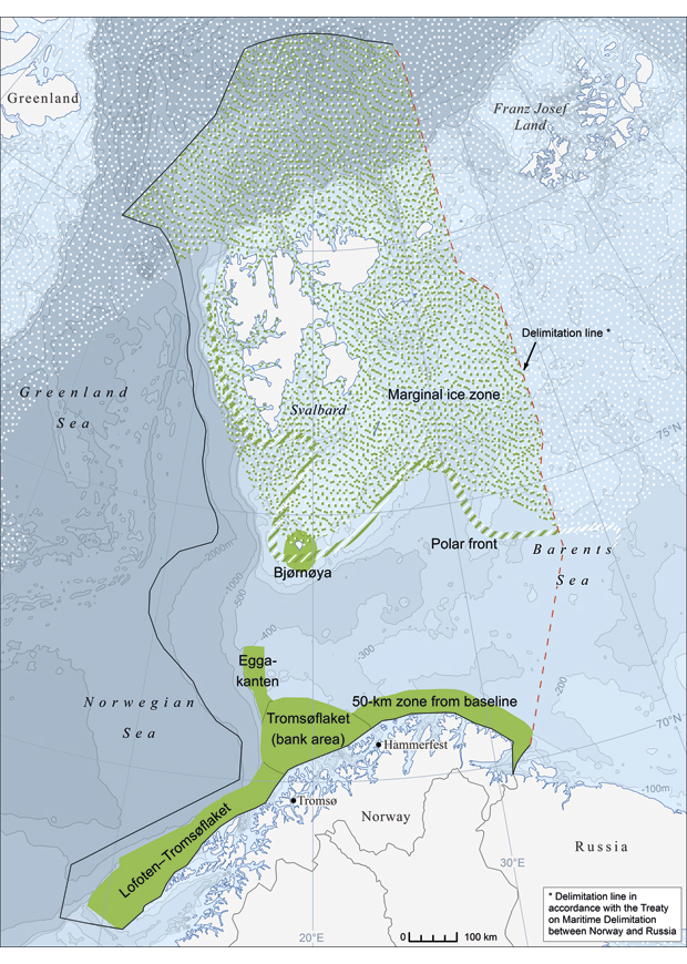
Figure 3.1 Particularly valuable and vulnerable areas in the Barents Sea–Lofoten area (shown in green)
Map data: Norwegian Polar Institute 2011
Source Depth data: IBCAO
The Barents Sea is a nursery area for important fish stocks such as cod and haddock, which spawn along the coast from the Lofoten Islands to Troms. The relatively narrow continental shelf off the Lofoten and Vesterålen Islands is especially rich and productive, and also functions as a conveyor belt for fish eggs and larvae. It is therefore particularly vulnerable to pollution.
The areas identified as particularly valuable and vulnerable have a combination of qualities; for example, they may have nutrient-rich seawater and high phytoplankton production, and function as spawning grounds or part of a spawning migration route for fish, or as breeding, moulting and wintering areas for seabirds. Other areas may be valuable because there are colonies, breeding areas or other concentrations of marine mammals such as grey seals, common seals, common porpoises and killer whales. Others again are classified as particularly valuable and vulnerable because there are sponge communities and coral reef complexes on the seabed, which in turn provide habitats for other species.
New knowledge has confirmed the environmental value of the areas identified as particularly valuable and vulnerable. These include the area from the Lofoten Islands to the Tromsøflaket, the Tromsøflaket bank area, and the Eggakanten area. Surveys have shown wide variation in habitat types and seabed landscapes, and observations include many new coral reefs, several habitat types that have provisionally been identified as new and several species that may be designated as species for which Norway has special responsibility. The presence of habitat types that are listed as threatened and/or declining by OSPAR has also been documented, see Figure 3.2. Most seabird species in many of the valuable and vulnerable areas are declining, particularly along the mainland coast. There is no new information indicating that the status of any of the areas identified as particularly valuable and vulnerable in 2006 should be changed.
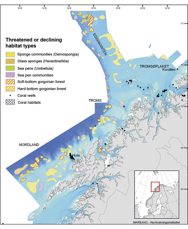
Figure 3.2 Parts of the Eggakanten area, the Tromsøflaket bank area and the area from the Lofoten Islands to the Tromsøflaket where there are habitat types listed as threatened and/or declining by OSPAR
Source MAREANO/Institute of Marine Research
Mapping of the seabed has shown trawl tracks and damage to certain coral reefs and sponge and sea pen communities in particularly valuable and vulnerable areas, but little is known about the implications of this for the ecological functioning and/or biodiversity of such areas. In other sea areas, it has been shown that sponge communities and coral reefs can be very important for the biodiversity and ecological functioning of the areas where they are found. This has not been specifically investigated in the Barents Sea–Lofoten area.
Existing knowledge does not provide an adequate basis for assessing whether more areas than those already identified should be designated as particularly valuable. New knowledge from mapping programmes may result in new assessments of which areas are particularly valuable and vulnerable.
Textbox 3.2 Vulnerability
Vulnerability can be defined as a measure of how liable a species or habitat is to be negatively affected by external, often anthropogenic pressures.
An assessment of the vulnerability of an area is generally based on which species and habitats occur naturally in the area and their reproductive capacity. Factors such as seasonal variations, distribution patterns, age/stage of the life cycle, behaviour and biological characteristics are used to determine the vulnerability of a particular species. Vulnerability to environmental pressures is assessed on the basis of the likely impacts of different pressures on the development and survival of a species or population. Some species are particularly vulnerable at times of the year when most of the population is concentrated in a limited area (for example fish during spawning and seabirds during the breeding season). The vulnerability of habitats depends on factors such as the substrate type (for example sand or rock), whether it contains sessile or motile species, and whether the habitat type is rare. Certain areas dominated by long-lived, habitat-forming species such as corals and sponges may be particularly vulnerable to certain environmental pressures because habitat formation can be such a slow process. Areas where biological production is high may be particularly vulnerable at certain times of year (for example when eggs and larvae (the early stages of fish) are present). Vulnerability can be measured at individual, population, community and ecosystem level. For management purposes, impacts at population, community and ecosystem level are most important.
3.2 State of the environment in the previously disputed area of the Barents Sea
When the Treaty between Norway and Russia concerning Maritime Delimitation and Cooperation in the Barents Sea and the Arctic Ocean enters into force, it will have implications for the management plan area as a whole. A larger area of the Barents Sea and Arctic Ocean will be under undisputed Norwegian jurisdiction. Together with the recommendations of the Commission on the Limits of the Continental Shelf, the Treaty means that all of the seabed west of the delimitation line will be part of the Norwegian continental shelf. As regards the water column in the previously disputed area, almost all the area west of the delimitation line will form part of Norway’s 200-mile zones, while a smaller area in the southwestern part of the Loophole will still be designated as international waters. The areas that will now come under Norwegian jurisdiction include parts of the relatively shallow bank areas Sentralbanken and Storbanken, but also a smaller area north of Svalbard where the water depth reaches 3 000–4 000 m. Until now, the whole of the previously disputed area has been included in the sections of the scientific basis for the management plan for the Barents Sea–Lofoten area that describe general environmental conditions, environmental pressures from human activity, etc, on the basis of existing knowledge. The joint Norwegian-Russian environmental status report also covers the whole of the previously disputed area. The knowledge base for this area does not differ greatly from that for other parts of the Barents Sea, except perhaps for the progress made in geological surveying of the petroleum potential.
The previously disputed area includes important nursery and feeding areas for fish, seabirds and marine mammals. A number of species also winter in this area, for example polar cod in the north and Northeast Arctic cod in the south. In the southern Barents Sea, the 50-km zone outside the baseline along the coast of Finnmark has been identified as a particularly valuable and vulnerable area. Central parts of the Barents Sea are also important wintering areas for a number of seabirds, including the common guillemot, which is critically endangered. The numbers of wintering common guillemots vary widely from year to year, but the reason for this is not known. There are particularly large concentrations of guillemots from the Russian breeding population in the area. In the shallow Storbanken and Sentralbanken areas, anticyclonic eddies form that prolong the residence time of the water masses in the area and therefore also concentrate organisms such as plankton that drift more or less passively with the currents. This phenomenon is exploited by animals at higher trophic levels in the food web, which are attracted to these areas. The current system, together with other physical factors that maintain high phytoplankton production, also results in an abundant benthic fauna in the shallow bank areas. The density of sea urchins is particularly high in the Sentralbanken area, and there are also concentrations of sea cucumbers in certain areas. The polar front also extends into the previously disputed area. This is an area of elevated biological production, and therefore an important feeding area for various groups of organisms; it is also a natural and dynamic biogeographical boundary, and therefore supports relatively high biodiversity. However, the eastern part of the polar front is broader and less clearly defined than it is further west. Sea ice covers part of the previously disputed area for periods of the year. The maximum extent of the sea ice varies from year to year, with wider variations further east. As the marginal ice zone moves northwards in spring, it is accompanied by fairly short-lived but intensive biological production. This makes it an important feeding area, where many groups of organisms may be present at high individual densities. However, the controlling factors and the intensity of biological production vary from the south to the deeper waters in the north. Both the polar front and the marginal ice zone have already been identified as particularly valuable and vulnerable areas in the management plan.
Since the 1980s, the previously disputed area has been closed for oil and gas activities, including seismic surveys, under a moratorium agreed by the Norwegian and Russian authorities. The incomplete information available on possible petroleum reserves in this area is therefore based on old data and very uncertain. The moratorium will lapse when the maritime delimitation treaty enters into force. In the 1970s, a few seismic surveys were carried out in the Norwegian part of the Barents Sea, mainly in the southern part. A number of seismic surveys carried out in the 1980s in the Russian sector of the Barents Sea (including the previously disputed area), together with information from exploration wells drilled near the delimitation line, suggest that there are promising petroleum structures in the area. The maritime delimitation treaty includes provisions on unitisation (meaning that any transboundary hydrocarbon deposit discovered will be exploited as a unit).
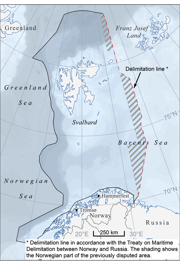
Figure 3.3 The Norwegian part of the previously disputed area
Map data: Norwegian Polar Institute 2011
Source Depth data: IBCAO
3.3 Specific ecosystem components
The following assessments of pressures and impacts on different ecosystem components focus mainly on changes since 2006. They also include a brief discussion of expected developments, with projections for 2025.
3.3.1 Physical/chemical environment
Climate change is expected to result in considerable changes in the Barents Sea ecosystem. Ice-dependent species will be under increasing pressure. Southerly species are expected to shift northwards, and there will be a similar displacement northwards of the southern distribution limits of Arctic cold-water species. Research since 2006 indicates that the first signs of such effects are becoming apparent in the Barents Sea.
Ocean acidification is expected to have major impacts on marine ecosystems, which will first become apparent in polar and subpolar regions. A large proportion of CO2 of anthropogenic origin ends up in the oceans, where it reacts with water to form carbonic acid, making the seawater more acidic (lowering the pH). This can have a range of impacts, particularly on organisms that build calcium carbonate shells and skeletons (see Box 3.3).
Textbox 3.3 Ocean acidification and its impacts on calcifying organisms
An equilibrium always forms between CO2 in surface sea water and atmospheric CO2. When CO2 dissolves in water, it forms carbonic acid, which makes the seawater less basic. Acidity is expressed as pH. A pH of 7 is neutral, solutions with a pH less than 7 are acidic and solutions with a pH greater than 7 are basic or alkaline. Since the industrial revolution, global surface ocean acidity has increased by 30 %. This means that the concentration of positive, acidic hydrogen ions (H+) ions has risen by 30 %, and that average pH has dropped from 8.2 to 8.1. The water is still on the basic side of neutral, but has become more acidic. In the decades ahead, a further reduction of 0.1–0.2 pH units is expected. Calcium carbonate forms when calcium and carbonate ions precipitate out of seawater. As the concentration of hydrogen ions rises, the concentration of carbonate ions decreases. If it falls below a critical level, the seawater becomes undersaturated in carbonate, and solid calcium carbonate can gradually dissolve.
Calcifying organisms mainly use calcium carbonate in the form of calcite or aragonite to build their shells and skeletons, and require a certain degree of supersaturation of these compounds in seawater for the process to function properly. Measurements show that there has already been some decline in the degree of calcite and aragonite saturation. Coldwater corals and a number of bivalves contain aragonite, the most soluble form of calcium carbonate. So does Limacina helicina, a sea snail that plays an important role in the marine food web. Crustaceans and echinoderms with calcium carbonate skeletons contain calcite, which is less soluble than aragonite, as do many groups of planktonic organisms. Ocean acidification may also have negative effects on sensitive biological processes such as reproduction, and on early life stages such as eggs and larvae.
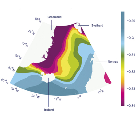
Figure 3.4 Projected changes in the acidity of surface seawater up to 2100
Source Bellerby et al 2005
Although there is already a measurable increase in the acidity of seawater, no damage to biodiversity has been shown as yet.
The ocean climate of the Barents Sea shows relatively wide variability. However, in the past 30 years the water temperature has shown a rising trend, and the extent of the sea ice has been shrinking. Continued warming of the Barents Sea–Lofoten area may result in major ecosystem changes. If the rising temperature allows adult herring to become established in the Barents Sea, for example, the capelin stock may remain at a permanently low level. This could have major impacts on other parts of the ecosystem. A combination of ocean acidification and higher temperatures could cause fundamental and irreversible changes. The impacts are difficult to predict, but may be far-reaching.
The extent of the sea ice has declined more rapidly than expected. Calculations made before the publication of the 2006 white paper indicated that the Arctic Ocean might be ice-free in summer for the first time in 60–80 years, but this is now expected to happen much sooner. Some recent models predict that the Arctic may be practically ice-free in summer before 2040.
In addition to long-term climate trends in the Barents Sea, there are short-term fluctuations from year to year. In 2006, the water temperature reached a maximum, and then declined, so that in 2010 it was a little below the trend line but above the long-term mean, as shown in Figure 3.5.
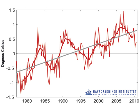
Figure 3.5 Temperature anomaly in the core of the Atlantic water flowing into the Barents Sea in the period 1977–2010. The figure shows measured values (thin red line), the 3-year moving average (thick red line), the linear trend for the whole period (bold grey line) and the long-term mean (horizontal grey line).
Source Institute of Marine Research
In 2006, the extent of the sea ice in winter in the Barents Sea reached a minimum, and has increased somewhat since then. On the other hand, there have been several ice-free summer seasons since 2000. The high water temperatures and shrinking sea ice have made larger parts of the Barents Sea accessible to cod and other species in recent years. This is probably one of the factors behind the recent growth in the cod stock. The inflow of water from the Atlantic Ocean is another factor that varies from year to year and is important for changes in water temperature and ice cover. The Atlantic water also transports large quantities of eggs, larvae and zooplankton into the Barents Sea. The inflow has declined somewhat in recent years from a previously high level.
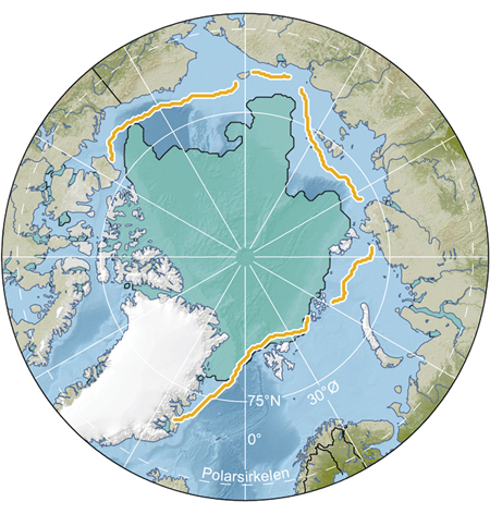
Figure 3.6 Extent of the sea ice in September 2010 (green shading) and average sea ice extent in September for the period 1979–2000 (orange line)
Map data: Norwegian Polar Institute, 2011.
Source Data sources: IBCAO, LP DAAC, NSIDC
It is difficult to say with any certainty how large a proportion of the already observed temperature change is a result of natural fluctuations and how much is a result of the rise in the CO2 content of the atmosphere. In several of the recent summer seasons, the ice cover in the Arctic has retreated further than previously. At the same time, as a result of the ice-melt far larger areas of the Arctic Ocean are covered in thin first-year ice.
The extent of the sea ice in the Barents Sea is now showing a tendency to increase after a number of years when the marginal ice zone has been retreating further and further north both in winter and in summer. The annual variations in nutrient concentrations are small, but show a weakly declining trend throughout the 15-year observation period. Atlantic water has replaced Arctic water on the northern part of the continental shelf west of Spitsbergen, possibly because there is little drift ice in the coastal current in this area. This has had far-reaching effects on the species composition of plankton and fish in the area. Changes in the diet of seabirds have also been observed. Climate change is expected to have a considerable effect on transport routes for hazardous substances to the management plan area and their spread within it. However, on the basis of current knowledge it is not possible to predict what the impacts will be.
Our knowledge of climate change, ocean acidification and sea ice indicates that these factors will be of considerable importance for ecosystem status and trends in the years ahead, and that the pace of change will be more rapid than previously expected. There are significant gaps in our knowledge of physical and biological processes in the marginal ice zone, the polar front and other productive areas. More knowledge is also needed on topics such as the inflow of Atlantic water in the future and the impacts of climate change on different ecosystem components. Inadequate knowledge of such key processes means that any assessment of cumulative effects on the ecosystems today and in the future is very uncertain. In cases where there is a lack of information for decision-making, the precautionary principle must be applied. Climate change, ocean acidification and shrinking sea ice cover are expected to be responsible for a substantial proportion of cumulative effects on ecosystems and species in the years ahead.
Projections for 2025
Projections for 2025 are uncertain, but climate change models indicate that there will be a rise in temperature, a reduction in ice cover and further ocean acidification. Such changes are expected to have impacts on the ecosystems of the Barents Sea–Lofoten area.
3.3.2 Phyto- and zooplankton
Phytoplankton production (primary production) is governed by light, the availability of nutrients and the layered temperature structure of the ocean. Changes in plankton distribution are also governed by such natural factors.
There are relatively small variations from year to year in the quantity of zooplankton observed in the Barents Sea. However, after 2006, when observed plankton quantities were higher than for the previous eight years, there was a weak decline until 2010, when the quantity increased again.
Because the quantity of zooplankton is so important, particularly for pelagic fish species, it is an important parameter to monitor so that indications of any changes that may have affected fish stocks and other species that are dependent on zooplankton are identified as soon as possible. Grazing by the large fish stocks influences the species composition and size of plankton populations. Thus, harvesting fish stocks has some indirect influence on the composition of the zooplankton.
It is difficult to identify any trend in phytoplankton production in the Barents Sea in the last 10–15 years, but biomass production varies considerably between cold and warm years. This is mainly explained by the variation in the area that remains ice-free in winter. A prolonged period of higher water temperatures has resulted in changes in the distribution of recycled nutrients in the Barents Sea, which in turn is influencing the distribution of the phytoplankton. The higher temperatures are closely linked to an increase in the inflow of nutrient-rich Atlantic water. Phytoplankton production in the polar front is limited to a relatively short season, but results in large concentrations of feeding fish and crustaceans in this zone.
Our knowledge of phyto- and zooplankton in the management plan area and the relationships between plankton and commercial plankton-feeding fish stocks has been considerably improved. Nevertheless, we do not have a good enough understanding of how variations in primary and secondary production affect other ecosystem components. At present, there is no adequate explanation of why there are still large fish stocks despite a reduction in the quantity of plankton.
3.3.3 The seabed and benthic fauna
In the areas off the Lofoten and Vesterålen Islands, the Eggakanten area and coastal areas off Troms, seabed mapping has shown wide variation in habitats and seabed landscapes, including many new coral reefs, several habitat types that have been provisionally identified as new, and new species. It has also shown that there is more damage to fragile benthic communities such as coral reefs, sponge communities and sea pen communities than has previously been documented.
Examples of new habitat types include «shallow shelf areas with moraines, iceberg plough marks and sponge habitats», «deep shelf areas with level sand and gravel bottom», and «lower continental slope with canyons». In general, biodiversity is highest in the shallowest hard-bottom areas. In the areas that have been mapped, the highest biodiversity has been found in the more southerly areas with a varied underwater landscape and wide variation in bottom types, for example off the Lofoten and Vesterålen Islands and the coast of Troms, while areas further north (the Tromsøflaket bank area and the transect northwards from the North Cape) are more uniform. Mapping in parts of two areas (Andfjorden transect and Lopphavet) that have been proposed for inclusion in Norway’s national marine protection plan has also revealed important and vulnerable species and habitats, including coral reefs and sponge communities.
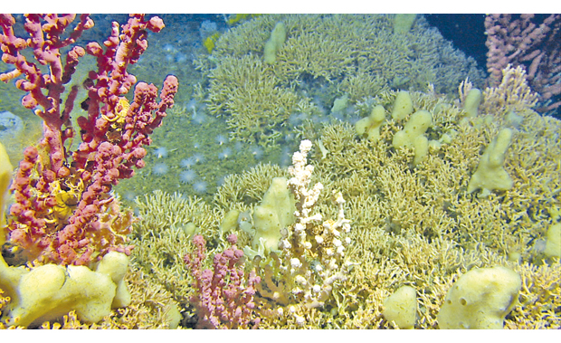
Figure 3.7 Coral reef with gorgonian corals and sponges
Source MAREANO/Institute of Marine Research
It is known from areas other than the Barents Sea that sponges grow slowly and that colonies function as habitat-building organisms. Highly specialised benthic communities develop in such habitats, which are stable over time, and these are dependent on the ecological functions provided by the sponge colonies. Sponges are also known to play an important role as shelter for larvae of various organisms during this vulnerable stage of their lives. At present, we have only limited knowledge about the ecological functions of different types of benthic organisms in the Barents Sea, but in areas where benthic communities have been studied, they have been shown to have important ecological functions. Knowledge of the impacts on benthic organisms in the Barents Sea is also limited. The MAREANO project has registered more than 1 400 different species and faunal groups in the management plan area. Many of these have been registered here for the first time, and some have not previously been found on the Norwegian continental shelf. About 100 species have been found further north than the previously known distribution limit. Several habitat types that have provisionally been identified as new have been described, including «gravelly bottom with basket stars» and«muddy bottom with sea lilies», and it has been suggested that certain species should be designated as species for which Norway has a special responsibility, including the sea pen Umbellula, the soft coral Radicipes and the bamboo coral Isidella. Radicipes has only been found in a landslide area (Bjørnøyaraset) at the northern end of Eggakanten, where there is a stand that has been characterised as unique and vulnerable. The results of MAREANO’s analyses of the relationships between marine landscapes and the fauna will be important in further development of the system of habitat types.
Textbox 3.4 The MAREANO programme
The MAREANO programme is systematically mapping depth and topography, sediment conditions, habitats and pollutants on the seabed. So far, the areas off the Lofoten and Vesterålen Islands and the coast of Troms, parts of the Tromsøflaket bank area, parts of the edge of the continental shelf and a transect northwards from the North Cape have been mapped. By 2010, a total area of 67 600 km2 had been mapped. This has provided valuable new knowledge, including maps of the underwater landscape, bottom types, trawl tracks, levels of pollutants in sediments and the distribution of habitat types, including vulnerable habitat types.
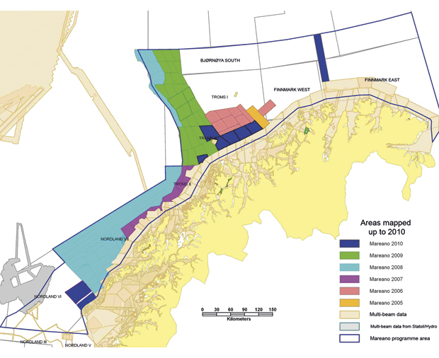
Figure 3.8 Areas where depth surveys have been carried out as part of the MAREANO programme
Source MAREANO/ Institute of Marine Research
Data from the MAREANO surveys are made available on the programme’s website and through the Norway Digital programme. The data are also being used by the Norwegian Biodiversity Information Centre in developing a new classification system for Norwegian habitat types, to map species distribution and in evaluation of the status of different habitat types. Data from other sources, for example the oil and gas sector and the Norwegian Defence Research Establishment, has also been made available to MAREANO and is included in the maps and databases.
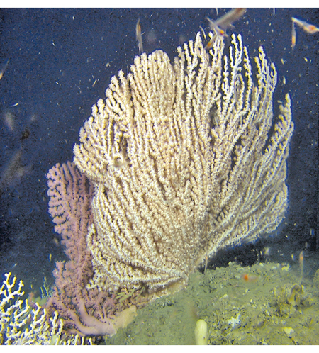
Figure 3.9 Part of a gorgonian forest
Source MAREANO/ Institute of Marine Research
Areas mapped by the MAREANO programme
The Tromsøflaket is a large, relative flat, shallow bank area dominated by sand and mud. There are large sponge communities, and many iceberg ploughmarks and moraine ridges on the seabed. East of the Tromsøflaket, in the deeper water of Ingøydypet, thousands of pockmarks have been observed on the seabed, which may indicate gas seepage. In the Eggakanten area, the continental shelf is dominated by sand and gravel, with sea anemones and sponges. The upper part of the continental slope is dominated by sea anemones and soft corals (Cladiella), and the lower part by tube-building polychaetes and small crustaceans in soft-bottom areas, and the Gorgon’s head (a sea star) and sponges in hard-bottom areas. Another feature of the Eggakanten area is a large area of rocks from an old landslide (Bjørnøyraset). The Håkon Mosby mud volcano lies in the western part of this area.
West of the Tromsøflaket, mud diapirs have been found. These are intrusions of clay that have been forced up through geological layers below the seabed.
Off the coast of Troms, there are two shallow, species-rich areas called Malangsgrunnen and Sveinsgrunnen, consisting of boulders covered with coralline algae, sponges and other sessile animals. There are also coral reefs, species-poor areas with large sand waves on the seabed, and soft-bottom areas where the fauna includes sea cucumbers and sea pens. This area also includes shallow bank areas near the coast with a strong current, where the sediments are coarser and there is more hard bottom than further west and north.
The most varied underwater landscape is found off the Lofoten and Vesterålen Islands, where shallow bank areas lie in close proximity to steep ravines that descend to a depth of up to 3 700 m. There is a rich fauna in the shallow areas, and the Norway lobster reaches the northern limit of its distribution here. There are 330 small, intact coral reefs, surrounded by sand, in an area called Hola. In deeper water, there is an Arctic fauna dominated by sea cucumbers, sea lilies, crustaceans and sea urchins. Geological structures and a bacterial film indicate that there are cold seeps at a depth of 1 200 m.
We do not have adequate knowledge of the benthic fauna and habitats for the whole management plan area, but this is being built up as part of the activities of various research institutes and as part of the monitoring system under the management plan. Several of the coral reefs in areas that have been mapped by the MAREANO programme have been found to be damaged. This means that the management objective for endangered and vulnerable habitat types (see Chapter 6.4.1) has not been achieved in the areas where the seabed has been mapped.
Several studies have been made of the scale of damage to coral reefs in the Barents Sea–Lofoten area. Their results do not provide a basis for concluding that damage from bottom trawling has increased. Much of the damage that has been observed is several years old. In the areas that have been mapped, approximately 20 % of the coral reefs are damaged to some extent, and about 6 % of all reefs that have been inspected in the entire management plan area have been destroyed.
An area called «Korallen» northwest of Sørøya island in Finnmark was protected against bottom trawling in autumn 2009.
Projections for 2025
The situation for the benthic fauna and benthic communities in 2025 will depend primarily on activity levels and the management measures that are implemented. In the past 10 years, the fisheries management authorities have focused increasingly on impacts on benthic communities, and a number of measures have been introduced. Although oil and gas activities can have limited local impacts on benthic communities, the industry must meet strict requirements to map and avoid damage to coral reefs and other valuable benthic communities. Temperature changes may result in a northward shift in the distribution of benthic species.
Many benthic species will be vulnerable to ocean acidification, but the scale of the direct and indirect impacts is uncertain.
3.3.4 Fish stocks
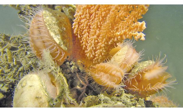
Figure 3.10 The clam Acesta excavata and a gorgonian coral, Tromsøflaket
Source MAREANO/ Institute of Marine Research
There are wide natural variations in the size of fish stocks. In recent years, natural conditions together with a sound management regime have resulted in historically high levels of key fish stocks such as cod, haddock and saithe.
Capelin, herring and cod play a key role in ecosystem dynamics in the Barents Sea, and together with Greenland halibut, golden and beaked redfish and blue whiting, they are used as indicator species in the monitoring system for the Barents Sea–Lofoten area.
Northeast Arctic cod: The spawning stock is at the highest level observed since 1947, and was estimated at over 1.14 million tonnes in 2010. In 2005, the spawning stock was 700 000 tonnes.
Herring and capelin: In 2010, the abundance of juvenile herring in the Barents Sea was low, while capelin abundance was high. This gives favourable conditions for many other species in the ecosystem. The large quantity of capelin is probably an important reason why the Northeast Arctic cod stock has been growing for several years, to the extent that the spawning stock is now as high as it was immediately after the Second World War.
To prevent harvesting from reducing the weak spawning stock of capelin, zero quotas were set for commercial fishing for capelin in the Barents Sea in the period 2004–08. In 2009 and 2010, the spawning stock was large enough to allow for a directed fishery during the winter, while at the same time it was calculated that there was sufficient capelin for the cod stock to feed on. Cod and capelin are included in a separate multi-species model which is used to calculate quotas. The quotas set by Norway and Russia are in accordance with harvesting rules approved by the International Council for the Exploration of the Sea (ICES).
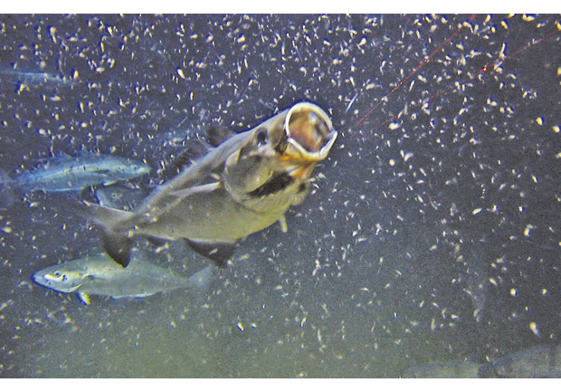
Figure 3.11 Saithe feeding on krill and other zooplankton
Source MAREANO/ Institute of Marine Research
Norwegian spring-spawning herring: The stock of Norwegian spring-spawning herring has been very strong in recent years, and the spawning stock has reached levels comparable to those observed in the 1950s. However, recruitment has been somewhat weaker in the last couple of years, and as a result the stock declined somewhat in 2010 from a peak in 2009.
The Barents Sea is an important nursery area for spring-spawning herring, but there is no fishery for juvenile herring in this area. Since 1999, the herring stock as a whole has been managed in accordance with a management plan adopted by the coastal states. The plan involves keeping the harvest below the precautionary level recommended by ICES, which is important in maintaining a stock with a high biomass. Adult herring do not live in the Barents Sea, but larvae drift into the area from the spawning grounds along the Norwegian coast. They remain in the Barents Sea for three to four years before migrating back to the Norwegian Sea, where they spawn. The three occasions when the capelin stock has collapsed since 1970 have all coincided with the migration of large year classes of juvenile herring into the Barents Sea. Nevertheless, there have been cases when capelin recruitment has been good even when the abundance of juvenile herring in the Barents Sea is high, probably because in certain years the two species use different parts of the area.
Coastal cod: Cod in coastal waters and the fjords is known as Norwegian coastal cod. There are several stocks from Stad at about 62°N to the border with Russia. The proportion of coastal cod relative to Northeast Arctic cod rises from north to south, whereas the quantity of coastal cod (number and biomass) rises from south to north, and about 75 % of the overall stock is found north of 67°N. Coastal cod are found from the kelp zone down to about 500 m. They spawn in the inner parts of most fjords and in tributary fjord arms of the larger fjord systems, but also in the same areas as Northeast Arctic cod. The larvae of coastal cod settle in very shallow water, and rarely move to deeper water before they are two years old. They reach sexual maturity earlier than Northeast Arctic cod, grow more rapidly and are less migratory. A plan for rebuilding the stock was adopted in spring 2010.
Textbox 3.5 Capelin as a key species in the Barents Sea
The capelin stock shows wide natural variations. The species is an important predator on zooplankton, and grazing pressure from capelin is so great that the quantity of zooplankton tends to decrease as the capelin stock increases, and vice versa. Capelin feed to a large extent in the marginal ice zone and migrate to Norway’s northern coast to spawn. They thus transport energy from biological production in the marginal ice zone to more southerly parts of the Barents Sea. Juvenile herring feed on capelin larvae, and this predation pressure can cause the capelin stock to collapse when the abundance of juvenile herring in the Barents Sea is high.
This became particularly clear when the capelin stock collapsed in the mid-1980s, the first of three occasions when this has happened since monitoring began in the early 1970s. The collapse of the capelin also resulted in the collapse of the common guillemot population and a decline in body condition in minke whales; it triggered mass migrations of harp seals, and the cod stock came under pressure, with poorer food supplies and high juvenile mortality as a result of cannibalism. The effects on species that feed on capelin were less dramatic in the two later periods when the capelin stock collapsed (1993–97 and 2003–06), partly because of greater availability of alternative prey. Capelin is an important prey for cod, seabirds and marine mammals.
Greenland halibut: The spawning stock has been low for many years, but has shown weak growth in the past ten years. It is classified as of «least concern» on the 2010 Norwegian Red List. From 2010, Norway and Russia introduced a joint management regime for Greenland halibut. The ban on a directed fishery has been repealed, and a three-year quota of 15 000 tonnes has been set. This was possible because a joint research effort has provided better knowledge of the biology and distribution of the stock.
Golden and beaked redfish: In 2005, ICES considered that both species had reduced reproductive capacity. Surveys showed a clear reduction in abundance, and indicated that both stocks were near a historical low. The year classes for the previous 10 years had been very low, and were declining. ICES recommended a ban on all directed fisheries, an expansion of area closures and stricter regulation of bycatches. The fisheries have been limited by close seasons, bycatch rules and gear restrictions, and this is still the case. These factors have helped to protect redfish larvae. There are now signs of better recruitment to the beaked redfish stock in nursery areas in the Barents Sea. However, in 2010, ICES still considered that both species had reduced reproductive capacity. The golden redfish stock is very weak, and this situation is expected to persist for many years. ICES therefore recommends stricter restrictions on the fisheries. The golden redfish is classified as endangered on the 2010 Norwegian Red List, while the beaked redfish is classified as vulnerable.
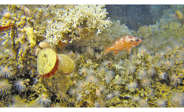
Figure 3.12 A redfish on a coral reef
Source MAREANO/Institute of Marine Research
Blue whiting: The Barents Sea is at the edge of the distribution area for blue whiting, and there is no blue whiting fishery in this area. In 2006, the species was included in the monitoring system as an indicator of climate change. The quantity of juvenile blue whiting in the Barents Sea has declined over the past six years.
There are also various fish stocks of minor commercial importance in the Barents Sea. Some of these, for example several species of skate, are in poor condition. The blue skate is classified as critically endangered on the 2010 Norwegian Red List. The basking shark and blue ling are now listed as endangered, while the porbeagle is still listed as vulnerable. There is no directed fishery for any of these species.
Knowledge about commercial fish stocks is generally satisfactory. Knowledge about non-commercial fish species, including sharks, is more variable and should be strengthened. Monitoring of the commercial stocks is well established and provides a good overview of the state of the various stocks. The annual ecosystem surveys in the Barents Sea carried out by the Institute of Marine Research also provide a good basis for monitoring non-commercial species.
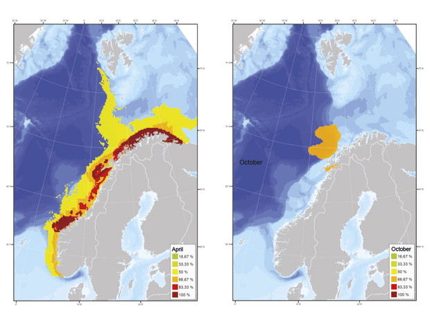
Figure 3.13 Internationally important areas for capelin, Norwegian spring-spawning herring and Northeast Arctic cod. The value of different areas for these species is expressed as percentages (the maximum value, designated as 100 %, is only assigned to spawning grounds). The maps show the situation in spring and autumn. The pattern for October is dominated by the wintering stock of Norwegian spring-spawning herring.
Source Institute of Marine Research/Directorate for Nature Management/DNVeritas
Projections for 2025
It is not possible to make reliable projections for fish stocks over such a long period, but there are many indications that management of the large commercial stocks will ensure that they are healthy and at full reproductive capacity. The main focus in the years ahead will therefore be on rebuilding smaller but important stocks, such as the two redfish species and Greenland halibut. In the short to medium term, rising temperatures are expected to result in rising quantities of fish in the Barents Sea, particularly in northern and northeastern parts. Climate change may cause changes in physical conditions and ice cover, which will have a considerable impact on the distribution of fish species. In addition, any harvesting of zooplankton may have an impact on fish stocks. Ocean acidification will have impacts on lower trophic levels in the food web and indirect effects on other ecosystem components, including fish.
As the marginal ice zone retreats northwards, new areas can be opened up for fisheries nearer the North Pole. However, it is uncertain whether the productivity of the Arctic Ocean and its peripheral seas will increase as the ice retreats and to what extent primary production will be channelled to fish species that are of commercial interest. In the Barents Sea itself, it is already possible to observe how fish species that have traditionally been found further south have moved northwards. However, various factors make it uncertain how ecosystems will respond to a warmer climate, and thus to draw a clear picture of which fish species can be expected to dominate and the size of stocks in the future.
3.3.5 Seabird populations
Status
In the past 10 years, many seabird populations in the Barents Sea–Lofoten area have shown a serious decline. This has affected a number of species, but the problems are greatest for the most abundant species, which typically breed in colonies and feed out at sea. In the more southerly and westerly parts of the management plan area, problems have also been registered for certain coastal species.
The common guillemot and black-legged kittiwake have shown a particularly severe decline, especially in the southwestern part of the management plan area. The situation for the common guillemot is so serious that it may only be a question of time before it is lost as a breeding species from many colonies along the Norwegian coast. The situation has been better further north in the Barents Sea, but the Brünnich’s guillemot population is now showing clear signs of a decline on both Bjørnøya and Spitsbergen. There are signs of a decline in the kittiwake population in this area as well. The glaucous gull population on Bjørnøya has been declining for the past 20 years, and the population has dropped by 65 % since 1986. Several of the large Atlantic puffin colonies have shown a negative trend in the past five years. Breeding success in the past four years has been below the action threshold defined in the monitoring system. A similar decline in kittiwake numbers has been observed across much of the North Atlantic, which indicates that the species’ problems may be linked to large-scale environmental change throughout the area. Climate change is therefore now being discussed as an important factor behind the decline in seabird populations, primarily through its effects on food supplies.
On the Norwegian mainland, populations of kittiwake, puffin, razorbill and common guillemot have been declining for many years. The common guillemot population here has dropped to only about 1 % of the 1980 level, while the kittiwake population is declining by 5–14 % per year, and is only 15–35 % of what it was 20–30 years ago. A substantial proportion of the Norwegian population of some of the seabirds listed as threatened on the 2010 Norwegian Red List (see section 3.3.7) is found within the management plan area; this applies to the common guillemot, Brünnich’s guillemot, black guillemot, puffin, razorbill, kittiwake, ivory gull and Sabine’s gull. The Steller’s eider, which breeds on the Russian tundra, winters on the coast of Finnmark. Other typical seabird species are placed in the «near threatened» category in the 2010 Red List: northern fulmar, white-billed diver, common gull, Leach’s storm petrel, Arctic skua, and (in Svalbard) king eider, brent goose and glaucous gull.
Almost all the seabird indicators show some degree of decline, both over the last ten years and for the entire period over which monitoring has been carried out.
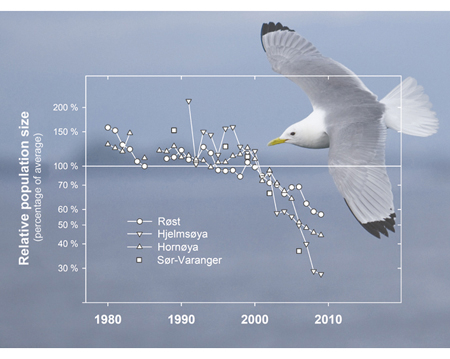
Figure 3.14 The breeding population of black-legged kittiwakes at the key localities monitored by the SEAPOP programme in the Barents Sea–Lofoten area has declined considerably in only a few years (data from the national monitoring programme for seabirds, Norwegian Institute for Nature Research
Photo: T. Anker-Nilssen
Source Management Forum for the Barents Sea–Lofoten area, 2010.
Seabirds are considered to be good indicators of change in marine ecosystems. They are easily visible elements in an environment where most animals and plants live below the water surface, they are easy to count, and they often concentrate in large numbers in productive marine «hotspots». Indicators for seabirds have two functions. Their numbers can be used both to indicate the availability of biomass in the upper water layers and as a basis for management of the seabird populations themselves. The role of seabirds in marine ecosystems means that they are one of the most vulnerable groups of marine organisms. At the same time, they are adapted to a constantly changing, unstable environment, where there are natural variations in food supplies. Seabirds are long-lived, which makes it difficult to identify environmental pressures and their impacts within a short time frame.
Food supplies
Changes in food supplies have been suggested as one of the main explanations for the severe decline in a number of seabird populations. A reduction in the amounts of important prey available is believed to be the key factor. The reasons for these changes are complex and only partly understood, but may include climate-related changes in marine ecosystems, lower production of prey (plankton and fish), changes in larval migration patterns, and variable recruitment to populations that are important prey for seabirds.
Many seabird species are particularly sensitive to the supply of pelagic, schooling fish species such as capelin and herring. From 2002 to 2005, there were very healthy year classes of juvenile herring, followed by a sharp rise in the capelin stock in the Barents Sea. The rise in the availability of capelin is one important reason why several of the seabird populations in eastern Finnmark and on Bjørnøya have not shown the same drop in breeding success as many populations of the same species further south. Along the coast of mainland Norway southwards from western Finnmark, breeding success and the status of breeding populations are considerably poorer. Off the Lofoten Islands, herring larvae drifting northwards are important food for many seabirds, but all the year classes of herring from 2004 onwards have been weak.
A lack of food at critical stages of the life cycle can partly explain the decline in certain seabird populations. Food shortages can be linked both to climate change and to the direct and indirect impact of the fisheries on populations of prey species. The most important factors altering food availability for seabirds are probably changes in the size of fish stocks and the balance between different species. Given that these complex relationships are also being influenced by large-scale climate change, it is difficult to identify the causes of the observed trends precisely. Through the SEAPOP programme, the authorities have initiated systematic mapping and monitoring of seabirds in all Norwegian sea areas. The objective of the programme is to obtain the necessary knowledge base for seabird management, including identifying general population trends and assessing the most likely causes of these trends.
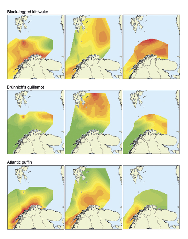
Figure 3.15 Distribution of seabirds (black-legged kittiwake, Brünnich’s guillemot and Atlantic puffin) in the open sea at different times of year. The maps show the situation in summer, autumn and winter. Green: low density. Red: high density
Source SEAPOP programme/Norwegian Institute for Nature Research
Knowledge about seabirds
Better knowledge of how seabird reproduction and survival (and diet) are affected by interactions between herring, capelin and cod seems to be a key to understanding the development of the largest seabird populations in the Barents Sea–Lofoten area. The SEAPOP programme has considerably improved the knowledge base in most areas, with the exception of bycatches of seabirds. Information on populations, their distribution, food choices, relationships with the distribution of food species, migratory paths and wintering areas has been considerably improved in recent years.
One of the remaining areas where more knowledge is needed is what impacts the management of the largest commercial fish stocks (including herring, capelin, sandeels, cod and saithe) have on seabirds. Marine ecosystems are highly complex, and an integrated ecosystem approach to management requires thorough knowledge of the different species and how they interact. However, ICES is already taking all components of natural mortality into account in today’s models when calculating recommended fish mortality levels and using these to calculate quotas. Predation by other species, including seabirds, is included in calculations of natural mortality. Natural mortality varies widely, but ICES takes this into account by basing its recommendations on a precautionary approach, so that the probability that stocks will be maintained at productive levels and thus continue to be available as a source of food for predators is as high as possible. A large spawning stock does not automatically provide good food supplies for seabirds. Seabirds feed largely on fish at earlier stages of their life cycle, and the models used by ICES do not estimate the abundance of these stages near the birds’ breeding grounds. No fishing for juvenile fish is permitted today. Moreover, a healthy spawning stock is no guarantee that all year classes of fish will be strong. Natural factors can result in poor recruitment even to stocks that are not fished at all, with resulting food shortages for seabirds. Fishing pressure on herring and capelin in the management plan area has not increased significantly in recent years. It is important to continue efforts to improve knowledge and understanding of the food needs of seabirds and the food available to them.
Information on bycatches of seabirds is incomplete and difficult to quantify, but work is in progress on this. More systematic mapping of the areas used by seabirds at different times of year and at different stages of their life cycle is also considered to be important.
3.3.6 Marine mammals and polar bears
Common porpoises are found all along the Norwegian coast and up to the polar front in the Barents Sea. Only a minimum estimate of population size is available for parts of this area, and we have no information on population trends. Monitoring by the Institute of Marine Research has shown that bycatches of porpoises are relatively large, but there is no sign that they are increasing. Locally, particularly in areas very close to the coast where there is an intensive gill net fishery, the bycatch mortality may be above the sustainable level for the local porpoise population. However, until the population structure has been clarified, it is not possible to judge whether the porpoise bycatch in the management plan area is reducing biodiversity, and whether the management objective set out in the Nature Diversity Act is being achieved for this species.
Surveys outside the management plan area suggest that the porpoise population is stable.
Every six years, the Scientific Committee of the International Whaling Commission (IWC) makes a scientific assessment of the minke whale stock, and the results of the assessment are used as a basis for the Norwegian management regime in the subsequent six-year period. For the management period beginning in 2009, the Scientific Committee estimated the total abundance of minke whale in the Northeast Atlantic and the Jan Mayen area at 103 000 animals. Norway’s annual catch of minke whales in recent years has been 400–600 animals.
A survey of the hooded seal population shows a steep decline in pup production since 1997. The observed reduction is probably not due to hunting. Climatic conditions have resulted in changes in the extent and quality of the drift ice in the West Ice, and we cannot rule out the possibility that a proportion of the hooded seal population have responded by moving to other areas for whelping. Another possible cause of the drop in pup production may be epidemic diseases such as phocine distemper virus (PDV) or bacterial diseases such as brucellosis (caused by Brucella) which has been recorded in seals in the North Atlantic. Because of the low pup production, no harvest of hooded seals has been permitted since 2007.
The ringed seal is one of several species that live on the sea ice and are dependent on good ice conditions to raise their pups. There has been a reduction in the area of sea ice of suitable quality, resulting in widespread reproductive failure among ringed seals along the west coast of Spitsbergen in recent years (2006, 2007 and 2008). Similar reproductive failure has also been observed in the traditional breeding areas for other ice-dependent species in areas bordering on the Barents Sea. In the White Sea, which lies south of the Russian sector of the Barents Sea, there has been a considerable drop in harp seal pup production in recent years, probably as a result of poor ice conditions. In the Norwegian Sea, the hooded seal has suffered a substantial reduction in pup production and a population decline, which have been linked to the reduction in ice cover in this area. Until larger geographical areas can be surveyed, it is not possible to decide whether this is a real population decline or whether there has been a change in the whelping areas the species are using in response to shrinking ice cover and poorer ice quality.
There has been no new survey of polar bear numbers in the management plan area since 2004. Information on population size and biology is generally satisfactory for marine mammal species that are or have until recently been commercially harvested (harp seal, hooded seal and minke whale), and the uncertainty in the stock estimates has been reduced. There are also satisfactory data on population trends for other whale species that are included in the annual sighting surveys. However, there is a lack of information on population sizes for the Arctic species ringed seal, bearded seal, walrus, narwhal and bowhead whale. It is important to monitor these species as well, and better data should also be obtained on common porpoise and beluga whale in the management plan area. Our knowledge of long-term changes in marine mammal populations as a result of climate change is limited. This information is particularly important for ice-dependent species.
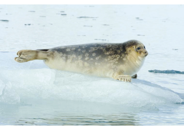
Figure 3.16 Ringed seal
Source Norwegian Polar Institute
Projections for 2025
Pressure from fishing and hunting is expected to remain unchanged or decline. Climate change will have a direct impact on the availability of suitable habitat for ice-dependent species (Arctic seals, ringed seal, polar bear). For other species, it may result in changes in the availability of prey. The impacts of climate change on marine mammals are expected to become more marked towards 2025. A growing volume of shipping and rising oil and gas activity may also have impacts on marine mammals, for example through increasing noise levels or collisions with ships.
3.3.7 Threatened species
If evidence indicates that a species is or may be at risk of extinction if a negative population trend continues, it is listed as critically endangered (CR), endangered (EN) or vulnerable (VU) on the national red list. These three categories together are referred to by the generic term «threatened species».
Species are placed in the different categories on the basis of an evaluation of the risk of extinction. The threat level is assessed on the basis of a set of five criteria developed by the International Union for Conservation of Nature (IUCN). The three most important elements of these criteria are:
A reduction in the population (meaning the number of reproductive/mature individuals) of the species.
The geographical range of the species consists of a few or small areas, is declining or is severely fragmented, or there is a known threat.
The species is very rare (population of less than 1 000).
The significance of the red list categories is the same for all species groups. However, differences in the generation length may have an impact, since in the final analysis this is what determines how long it takes before a species becomes extinct.
The information on threatened species in the 2006 white paper was based on the 1998 Norwegian Red List, which did not include marine fish. A new Red List including marine fish was drawn up in 2006. The Red List was updated again in 2010, and some adjustments were made to the criteria. The Red List status of a number of species that occur in the management plan area has been changed from 2006 to 2010. In some cases a change in category reflects a real population change, whereas in others it reflects better knowledge of the population.
The 2006 Norwegian Red List categorised 27 species that occur in the Barents Sea–Lofoten area as threatened. In the 2010 Red List, this has increased to 36 species.
Textbox 3.6 From the 2010 Norwegian Red List
Species Category in the Red List
European eel Critically endangered
Blue skate Critically endangered
Spiny dogfish Critically endangered
Basking shark Endangered
Blue ling Endangered
Golden redfish Endangered
Porbeagle Vulnerable
Beaked redfish Vulnerable
Common guillemot Critically endangered
Black-legged kittiwake Endangered
Razorbill (Svalbard) Endangered
Razorbill (mainland Norway) Vulnerable
Black guillemot Vulnerable
Atlantic puffin Vulnerable
Steller’s eider Vulnerable
Common tern Vulnerable
Brünnich’s guillemot Vulnerable
Ivory gull (Svalbard) Vulnerable
Sabine’s gull (Svalbard) Endangered
Common guillemot (Svalbard) Vulnerable
North Atlantic Right whale Regionally extinct
Bowhead whale Critically endangered
Hooded seal Endangered
Narwhal Endangered
Common seal Vulnerable
Walrus (Svalbard) Vulnerable
Common seal (Svalbard) Vulnerable
Polar bear (Svalbard) Vulnerable
The indicator for threatened species in the Barents Sea–Lofoten area is still being developed. Work on vulnerable and endangered species has been stepped up, and this has improved the knowledge base.
Figure 3.17 Red-listed species in the management plan area. Walrus (vulnerable), polar bear (vulnerable), common guillemot (critically endangered), golden redfish (endangered)
Photos: Kit M. Kovacs and Christian Lydersen (walrus, polar bear), Hallvard Strøm (common guillemot), Institute of Marine Research (redfish).
Projections for 2025
See the text on each species group.
3.3.8 Alien species
The spread and introduction of alien organisms can have impacts on important elements of the ecosystem. In the management plan area, the alien species with the largest population and widest distribution is the red king crab. The species is also used as a harvestable resource in the fisheries. The red king crab is an invasive species that may damage important elements of the ecosystem, as further discussed below. In recent years, the combination of the commercial fishery east of 26°E (North Cape) and harvesting of all sizes of crabs in an effort to control the species west of 26°E has had a considerable effect, and the king crab population in Norwegian waters has been substantially reduced. However, it is a problem that Russia, where most of the population is found, manages the species solely as a resource. The king crab is protected in a large area along the coast adjoining the Norwegian border. As a result, there is a steady influx of crabs along the coast of Finnmark.
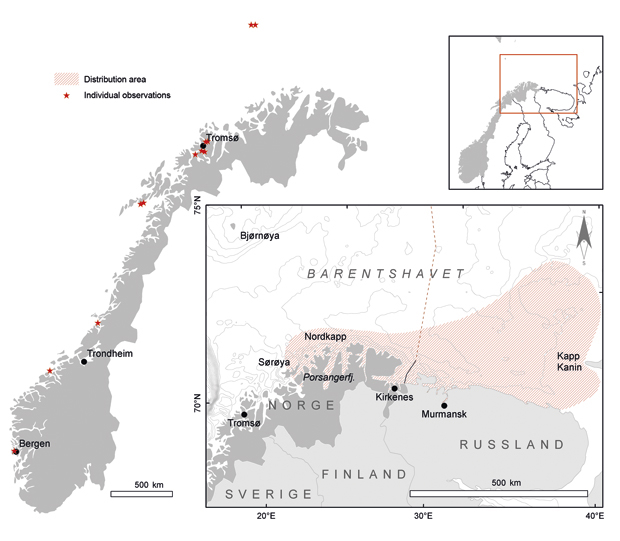
Figure 3.18 Bycatches of snow crabs by fishing vessels (black stars) and during surveys by the Institute of Marine Research (circles) in the period 2004–10. The size of the circles indicates the relative number of crabs caught at each position
Source Institute of Marine Research
Monitoring alien species
The indicator for alien species in the monitoring system is still being developed. So far, it is recommended that two species, red king crab and snow crab, should be closely monitored. There are strong indications that the snow crab is developing a more northerly distribution in the Barents Sea than the red king crab. The westerly distribution of the latter has changed since 2006. In 2010, a substantial amount of red king crab was harvested near Sørøya (west of Hammerfest), which is further west than previously.
Estimates of the total population of red king crab (individuals of carapace length more than 70 mm) for 2010 are somewhat lower than for 2009. On the other hand, bycatches of snow crab in gillnet and longline fisheries in eastern Finnmark were higher in 2009 than in previous years.
Figure 3.19 Approximate distribution of red king crab in the Barents Sea (red hatching) and individual observations of the species (red stars). Individuals found around the Lofoten Islands and further south are most likely to have been released. Those observed further north may have spread to these areas or have been released. Individual observations were registered in the period 2002–11
Source Institute of Marine Research
Impacts of red king crab and snow crab on the ecosystem
The red king crab has impacts on the benthic fauna that we were not aware of in 2005. More recent investigations in the Varangerfjorden (2008/09) have shown the species is causing substantial changes in soft-bottom benthic communities. A comparison with the situation before the red king crab became abundant in the areas studied (1995) shows a dramatic decline both in the number of species and in biomass. In addition, the investigations confirm that large individuals of bivalves, echinoderms and polychaetes are more or less absent. It is unclear whether these are permanent effects. The Varangerfjorden studies indicate that when the crabs remove the dominant benthic organisms, oxygenation in the sediments is reduced. Research in the Russian part of the Barents Sea has yielded similar results, but the reduction in species diversity and biomass is considerably less marked than that found in Norwegian waters in the Varangerfjorden.
Increasing numbers of snow crabs are being found in the Barents Sea. The original range of the species was the Bering Sea, northeastern Canada and west of Greenland. It is not known whether larvae have been introduced with ballast water or whether the species has spread into the management plan area itself. Genetic studies are being carried out to determine the origin of the crabs in the area. So far, no research has been carried out on the effects of snow crab on the ecosystem. The crabs feed on benthic animals, and it is expected that any impact will be primarily on benthic communities.
Projections for 2025
The risk of the spread of alien species via ballast water is expected to be considerably reduced when the Ballast Water Convention enters into force and strict requirements for ballast water treatment are introduced. If the convention is not yet in force in 2025, the outlook is uncertain, but a rising volume of shipping, particularly tankers, will increase the risk that alien species will be spread with discharges of ballast water and on ships’ hulls. A warmer climate may increase the likelihood that species introduced from further south will be able to establish themselves in Norwegian waters. Traffic through the Northeast Passage would increase the risk of introductions from distant areas with a similar marine climate, particularly from the species-rich Pacific Ocean to the Barents Sea. A rising temperature may also affect the distribution of the red king crab and snow crab. It is uncertain how much impact these two species will have in 2025.
3.3.9 Pollution
Long-range transport of pollutants with air and ocean currents is the main source of pollution in the management plan area. More intensive monitoring since 2006 has given us more insight into the state of the environment, and the results show that pollution levels in the Barents Sea–Lofoten area are low. Seafood from the area is generally safe, and the Arctic areas are considered relatively unpolluted at present. However, the Arctic is more vulnerable to pollution than other regions. Animals at the upper trophic levels of Arctic food chains accumulate considerable concentrations of fat-soluble pollutants, probably mainly because Arctic animals rely on fat for survival, both as an energy reserve and as insulation. New pollutants are constantly being detected in the region through regular screening studies.
Monitoring system strengthened since 2006
In the 2006 management plan, it was decided to introduce a more integrated monitoring system, with indicators, reference values and action thresholds, for the Barents Sea–Lofoten area, including closer monitoring of pollution levels in the marine ecosystems. A set of pollution indicators was chosen to cover inputs of pollutants via different routes (atmospheric inputs, inputs via rivers, marine beached litter) and environmental pollution (in sediments, benthic animals, fish, birds, seals and polar bears).
Textbox 3.7 The Marine Pollution Monitoring Programme
The Marine Pollution Monitoring Programme was started in 2009 in direct response to the 2006 management plan for the Barents Sea–Lofoten area, which had identified serious gaps in our knowledge of pollution in open sea areas. It is a broad-based monitoring programme that in the longer term is intended to provide an overall picture of the pollution status of Norwegian sea areas. It has the following goals:
to identify the most important sources of pollutants (oil and environmentally hazardous substances, including radioactivity);
to provide an overview of inputs of pollutants and transport routes to sea areas;
to document the status of selected indicators of pollution;
to monitor changes in sources, pressures and status over time;
to provide an overview of the pollution status of Norwegian sea areas.
The programme brings together expertise on a wide variety of areas from a number of leading Norwegian research institutions.
The programme covers all routes for inputs of pollutants to the sea, including ocean currents, the atmosphere, runoff from land, leaching from bedrock and marine sediments, and releases from shipping and oil and gas activities in Norwegian sea areas.
The programme focuses on one sea area each year: the Barents Sea in 2009, the North Sea in 2010 and the Norwegian Sea in 2011. To give a more representative picture of inputs via air and ocean currents in the Barents Sea–Lofoten area, a new measuring station was established on Andøya (Vesterålen Islands) in 2010, and passive samplers were deployed on Bjørnøya and Jan Mayen.
The programme makes use of and supplements other monitoring programmes run by agencies including the Climate and Pollution Agency, the Institute of Marine Research, the National Institute of Nutrition and Seafood Research, the Norwegian Institute for Water Research, the Norwegian Institute for Air Research, the Bjerknes Centre for Climate Research and the Norwegian Radiation Protection Authority.
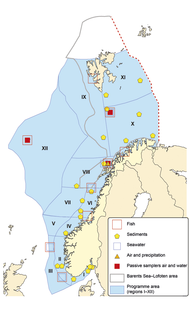
Figure 3.20 Measuring stations for the Marine Pollution Monitoring Programme in Norwegian waters in 2010
Source Institute of Marine Research, Norwegian Institute for Water Research, Norwegian Institute for Air Research, National Institute of Nutrition and Seafood Research, Norwegian Radiation Protection Authority, Climate and Pollution Agency
Monitoring and mapping activities have been scaled up considerably since the 2006 management plan was published, particularly as regards the selected indicators. The indicators have also been further developed. Even though it has not been possible to start satisfactory monitoring of all the indicators, we have developed more insight and knowledge about the pollution status of the management plan area. Appendix 2 provides an overview of the different pollution indicators and the data available.
Long-range transport the main source of pollution
Concentrations of organic pollutants in the atmosphere and precipitation have been monitored in Svalbard since the early 1980s. The results show a downward trend for most of the «classical» persistent organic pollutants (POPs), but in the last two to six years (varying from one substance to another), this positive trend has stagnated for DDT, polychlorinated biphenyls (PCBs), polycyclic aromatic hydrocarbons (PAHs) and hexachlorobenzene (HCB). There are several possible explanations for this: continued use of DDT in other parts of the world, the release of these pollutants from environmental sinks as a result of climate change, an increase in the evaporation of previously deposited HCB and PCBs with an increase in the number of forest fires, the reduction in ice cover, and larger inputs of relatively warm Atlantic water.
Knowledge about the presence of new organic pollutants and time trends for their concentrations is more limited because the measurement series are shorter, but levels of polybrominated diphenyl ethers (PBDEs) are showing a tendency to decline, while levels of perfluoroalkyl substances (PFAS) are rising.
The 2006 white paper indicated that a continued rise in mercury levels was expected up to 2020, whereas a decline was expected for other metals. However, mercury levels in air have now been stable for a number of years, and the expected decline in atmospheric inputs of other heavy metals has not been observed, with the exception of nickel.
Radioactive substances carried with the coastal current
Radioactive pollution is largely transported to the management plan area in the Norwegian coastal current. There are low levels of radioactive substances in the Barents Sea, and levels in the Arctic are generally declining. Caesium-137 from the Baltic Sea, which originates from Chernobyl, is the most important source of inputs of this substance to the management plan area. Releases of technetium-99 from the reprocessing plant for spent nuclear fuel at Sellafield on the west coast of England have been reduced since 2003/2004, as a result of the introduction of a new method of waste treatment.
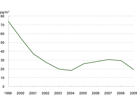
Figure 3.21 Annual mean concentrations of sum PCB in air at the Zeppelin station in Svalbard, 1999–2009
Source Norwegian Institute for Air Research
Inputs from neighbouring areas less important
There are still only a few large onshore or coastal sources of pollution near the management plan area. Sediments in several ports are contaminated by pollutants released from ships and shipyards. Other routes for inputs of pollutants – transport with ice, runoff from land and inputs via rivers – are assumed to be less important in the management plan area, but may be of local significance. There are appreciable levels of nickel and copper pollution in the Pasvikelva river in eastern Finnmark, along the border with Russia, largely transported by air from the Pechenganikel nickel works. Otherwise, the levels of pollutants measured in rivers (Altaelva, Barduelva, Tanaelva and Pasvikelva) are low. The impacts of pollution from mining and quarrying in northern areas will be largely local and not affect the management plan area itself.
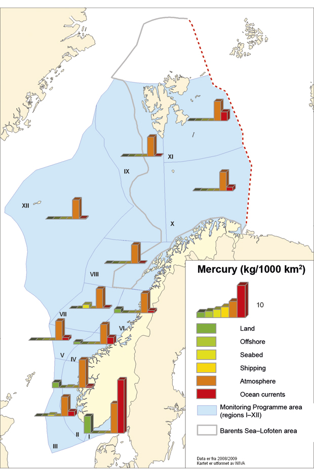
Figure 3.22 Inputs of mercury by source and area, 2008/2009
Source Marine Pollution Monitoring Programme/Norwegian Institute for Water Research
Pollution status for the seabed
A great deal of work has been done on mapping and monitoring levels of pollutants, particularly concentrations of oil and metals, in the seabed sediments of the Barents Sea in the period 2003–09. Many hazardous substances bind to particulate matter and organic material, and therefore end up in sediments. Levels of hazardous substances and radioactive substances in sediments will therefore reflect the pollution status of the area. Pollutants can spread from the sediments to the water column and organisms.
The results show that levels of PAHs and total hydrocarbon content (THC), which are used as indicators of oil pollution, are relatively low, but there is a good deal of variation in hydrocarbon levels in sediments in different parts of the management plan area. This variation can be explained by the geochemical origin of the sediments, including natural leaching and erosion of fossil fuels (coal/oil). In addition, a small proportion of these substances may originate from inputs of oil and other fossil fuels from various human activities.
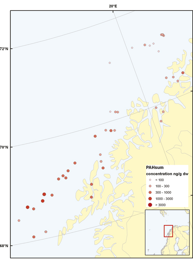
Figure 3.23 PAH levels in surface sediments
Source Institute of Marine Research
Analyses of surface samples from the seabed show that levels of heavy metals, organochlorine compounds and man-made radioactive substances are generally low. Time trend analyses of samples from deeper areas (Malangsdjupet and Ingøydjupet) indicate a weak rise in inputs, particularly of the heavy metals lead and mercury, over a period of 50–70 years. Thus, although pollution levels are still low, human activity is having a detectable effect in the management plan area as a result of long-rang transport of pollutants. Low concentrations of organic pollutants have been found in sediments throughout the management plan area, and are also a result of human activity.
Levels of radioactive substances in sediments in the management plan area are low. The annual monitoring programme for radioactivity in sediments around the wreck of the nuclear submarine Komsomolets, which lies on the seabed at a depth of 1 700 m south-west of Bjørnøya, shows that caesium levels in the sediments are no higher than in the surrounding waters, but small releases of radioactivity to the environment have been registered.
Pollution levels in organisms
Studies of POPs in seabirds and marine mammals show that international regulation of several substances, such as PCBs and organochlorine pesticides, is having a positive effect.
A study of ringed seals from Svalbard in the period 1996–2004 showed a reduction of 50–80 % in levels of PCBs and organochlorine pesticides. Glaucous gulls have been monitored for 35 years, and the results show that levels of most PCBs and organochlorines have declined. The insecticides DDT and DDE are an exception to this: there has been no decline in levels in polar bears and glaucous gulls in the past 10 years. This indicates that DDT is still being transported to the area or is being released from environmental sinks as a result of climate change.
There are indications that the downward trend in PCB concentrations in polar bears is continuing (based on data from Svalbard up to 2008), and that there may be less pressure on polar bears as a result. However, despite the decline in levels of certain pollutants in polar bears, concentrations are still high. Levels of POPs, primarily PCBs, in parts of the polar bear population in Svalbard and Franz Josef Land (no new data obtained since 1995) exceed the thresholds for effects on the hormone and immune system. There is therefore reason to believe that POPs in polar bears are having a negative impact on the immune system and on reproductive capacity. Levels of POPs measured in Brünnich’s guillemot eggs are all below the thresholds for effects on reproduction and/or survival.
Radioactivity levels have been measured in several marine mammal species since 2000 and in seabirds since 2005. The levels are low, but a comparison of caesium-137 concentrations in marine mammals and in their prey suggest that caesium-137 accumulates from one level to the next in the food chain.
Trends for mercury are less clear, with a decline in polar bears but no change in seabird eggs.
PCBs have been shown to have a negative impact on reproduction in seals. Ringed seals and harp seals, which are the most important prey species for polar bears, have a limited ability to metabolise POPs, and have accumulated high concentrations of PCBs.
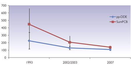
Figure 3.24 Levels of PCBs and DDE in Brünnich’s guillemot eggs from Kongsfjorden (Svalbard) and Bjørnøya
Source Institute of Marine Research
Levels of pollutants in fish and shellfish are generally low in the Barents Sea.
It is extremely important to monitor pollutant levels in fish and shellfish to ensure that the seafood placed on the market is safe. For most of the indicator substances for food safety, measured values in seafood are well below the specified maximum levels. However, results from monitoring in the Barents Sea since 2006 show that the content of contaminants is variable and in certain cases exceeds statutory maximum levels. Systematic surveys are therefore needed to provide information on trends. Knowledge is also needed on the reasons for variations between species and geographical areas.
Textbox 3.8 Safe seafood
Maximum limits have been set for the content of a number of pollutants in fish and other seafood. Some of the results from monitoring by the National Institute of Nutrition and Seafood Research since 2006 are as follows:
Mercury dominates among contaminants in lean fish, whereas dioxins, PCBs and other organic pollutants are most often found in fatty fish.
Measurements in cod fillet, shrimps, capelin and polar cod show low values for all pollutants that have been tested. Levels of heavy metals in cod are below the maximum levels set for human consumption. The average values for cadmium, mercury and lead in cod fillet have remained at about the same level since monitoring began in 1994. Levels of dioxins and dioxin-like PCBs in cod liver are close to the maximum level for human consumption.
The maximum level for mercury is exceeded in certain fish species. Levels of mercury are not a problem in the most important products from the Barents Sea, such as cod fillet. However, high mercury levels are found in halibut and Greenland halibut, especially in large mature specimens. This had not been documented in 2005. For Greenland halibut, the results show that the mercury content is lower in fish caught off the coast of Finnmark than in those caught along the edge of the continental shelf and northwards towards Svalbard.
New data show that a substantial proportion of Greenland halibut caught along the edge of the continental shelf and northwards towards Svalbard contain concentrations of organic pollutants exceeding maximum levels, while levels in fish caught off the coast of Finnmark are considerably lower.
Radioactivity levels in fish and seafood have been monitored since 1991. Levels measured in both fish and shrimps are low. Levels of caesium-137 in cod have shown a downward trend in the period 1991–2008, which is to be expected since the main source of the substance is the 1986 Chernobyl accident, and its half-life is 30 years.
There are indications that environmental levels of the best known new POPs that have now been regulated (for example the brominated flame retardant PBDE) are declining.
However, low concentrations of emerging POPs that have not been regulated can also be detected, and some of these may be showing an upward trend. Surveys of organophosphorus flame retardants show higher levels in cod species in the Barents Sea than in coastal cod in fjords in southeastern Norway. Such finds are unexpected, since the reverse is generally found for classic POPs.
Focus on marine litter is needed
Large quantities of litter wash up on the beaches in the management plan area. Litter along the shoreline is used as one of the indicators in the monitoring system to assess whether the target of avoiding litter and other environmental damage caused by waste from activities in the management plan area is being achieved.
The only time series for litter from the management plan area is organised by the Office of the Governor of Svalbard. Litter has been cleared from three short stretches of shoreline in Svalbard and weighed each year since 2001. This material is not sufficient to draw any definite conclusions about trends in the quantity of litter. The fishing fleet in the Norwegian and Barents Seas is assumed to be the source of most litter along the shoreline in Svalbard, but a good deal may also originate from cruise ships. Litter is found scattered over wide areas, and the problem is greatest along the northwestern coast of Spitsbergen.
Another problem is that there are variations in the types of litter registered and the methodology used. In 2010, a beach survey and clean-up was carried out at Kvaløya in Tromsø municipality in accordance with OSPAR’s methodology for marine beach litter surveys. The results showed that plastic litter from the fishing and aquaculture industries was the category of litter most frequently found in this area.
The Norwegian authorities have not established a system for reporting waste streams from ships to land-based reception facilities. This means that there are no figures available that provide any information on trends.
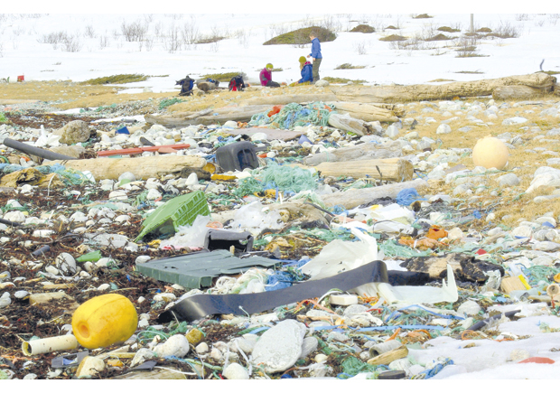
Figure 3.25 Litter on the beach at Rekvika bay, Tromsø municipality
Source Climate and Pollution Agency (photo: Bo Eide)
Plastic litter can be a major threat for example to surface-feeding birds such as fulmars and to marine mammals, which may become entangled and drown, or ingest plastic litter and suffer damage to the digestive system. This is a serious problem in other sea areas, but not much is known about the scale of the problem in the Barents Sea.
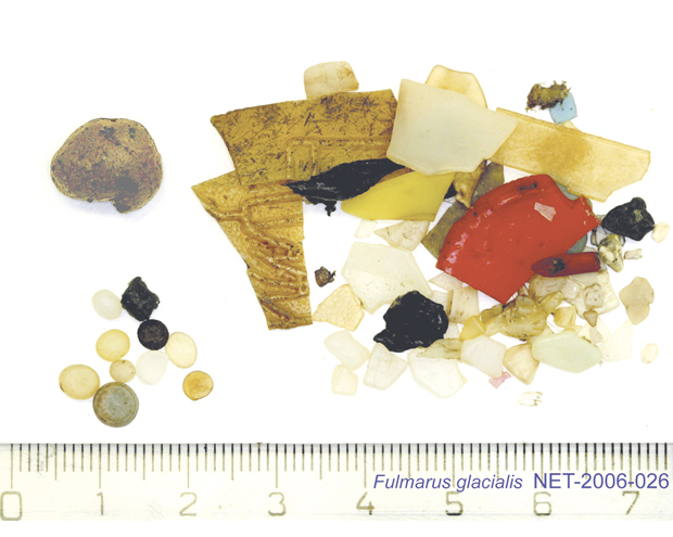
Figure 3.26 Fragments of plastic in the stomach contents of a fulmar
Source OSPAR/KIMO. Photo: Jan van Franeker
Projections for 2025
Climate change is expected to have a considerable effect on transport routes for hazardous substances to the management plan area and their spread within it. However, on the basis of current knowledge it is not possible to predict what the impacts will be. It will therefore be important to focus on building up knowledge of the impacts of climate change.
The reduction in inputs of several of the substances that are subject to international regulation has stagnated. It is uncertain why this has happened, and difficult to predict what will happen in the future. A continued reduction in levels of classic POPs would be expected as their use is halted globally, but it is uncertain to what extent this is being counteracted by rising inputs as a result of climate change. The situation as regards new POPs will depend on how their use is regulated globally. If there is a global decline in inputs of dioxin-like PCBs to the environment, concentrations in fish and other seafood would be expected to decline in the period up to 2025.
3.4 Most important knowledge needs in the future
According to the 2006 white paper, our general knowledge of the Barents Sea–Lofoten ecosystems is fairly comprehensive, but we need to know more about interactions between species in the food chain. The 2006 white paper further points out that studies of the ecology of the area have been concentrated on a small number of species. We still know little about the impacts of human activity on the various parts of the ecosystem, particularly the synergistic effects of different pressures.There are still gaps in our knowledge in certain areas that were highlighted in 2006, including the transport, accumulation and impacts of hazardous substances and radioactive substances. More knowledge is also needed about the synergistic effects of interactions between hazardous substances and between hazardous substances and other stress factors such as climate change, food shortages and disease. The report from the Management Forum points to the need for more knowledge about the resilience of the ecosystems in the Barents Sea–Lofoten area to major changes, or regime shifts. Ecosystems are generally resilient to large-scale change. However, it is important to learn more about the factors that influence resilience to change in ecosystems of the management plan area. Variations in climate and pressure from human activities determine the framework for sustainable development in the area. Developing an understanding of which processes can cause irreversible change and how resilient the Barents Sea–Lofoten area is to change is an important cross-cutting topic.
Baseline studies and long time series will always be important, and should in many cases be included when planning how to meet knowledge needs; examples are monitoring of ocean acidification, seabird populations and inputs and levels of pollutants. It is therefore important to continue existing programmes such as MAREANO, SEAPOP and the Marine Pollution Monitoring Programme, and to strengthen other monitoring coordinated by the Advisory Group on Monitoring. A systematic monitoring programme for inputs of marine litter to the shoreline throughout the management plan area should also be established, and more knowledge is needed about the origins of the litter.
Increasing attention is being paid to the problem of ocean acidification, and also to interactions between the impacts of ocean acidification and climate change, and between these and the impacts of human activities such as fisheries, petroleum activities and shipping. Ocean acidification and climate change may also affect the transport of pollutants into the management plan area and how they accumulate in and are metabolised by living organisms.
It is also important to develop technology and know-how that can be used to prevent or reduce anthropogenic pressures and impacts.
Climate change in the Barents Sea–Lofoten area may have major impacts on ecosystems and society. Calculations using current global and regional climate models indicate that there will be major change in the future. However, process understanding needs to be improved, and better modelling tools are needed to build up knowledge of impacts on ecosystems and consequences for society. It is also important to focus on the impacts of climate change on technology and industrial structures and the risk of accidents. Knowledge in many other areas will also be relevant to the cross-cutting area of climate change and its impacts.
More knowledge is needed about environmental pressures and their impacts, particularly as regards the cumulative environmental effects.
We need to know more about the importance of the management plan area for value creation and Norwegian society, for example through studies of the importance to society of ecosystem services that are not associated with a particular industry and that are not at present traded in a market.
There is also a considerable need for more knowledge of benthic conditions and cumulative effects on benthic habitats and organisms.