7 New measures for the conservation and sustainable use of ecosystems
The 2006 management plan for the Barents Sea–Lofoten area (Report No. 8 (2005–2006) to the Storting) set out a number of measures to ensure integrated, ecosystem-based management of the area, reduction of pollution, and protection of biodiversity. This white paper describes how the measures are to be continued, supplemented and updated. The Government’s assessments and conclusions are based on new knowledge about the environment and natural resources, current trends, and projections relating to the environment, industries, socioeconomic conditions and risk levels.
The management plan clarifies the overall framework and encourages closer coordination and clear priorities for management of the Barents Sea–Lofoten area. It increases predictability and facilitates coexistence between different industries. New data, particularly on benthic conditions and seabirds, confirms and strengthens the scientific basis for identification of the particularly valuable and vulnerable areas specified in the 2006 management plan. These are areas that are important both locally and for ecosystem functioning in the entire management plan area. Surveys have built up knowledge about oil and gas resources in the waters off the Lofoten and Vesterålen Islands and Senja.
In the 2006 management plan, the Government stated that it considered the state of the environment in the Barents Sea–Lofoten area to be generally good, and this is still the case today. In the Government’s view, and on the basis of existing knowledge, the main tasks in the period between now and 2020 will be related to long-range transboundary pollution, climate change and ocean acidification, the decline in seabird populations, the risk of acute oil pollution, and further development of the different elements of an ecosystem-based management regime.
Human activity in the management plan area is expected to increase in future, and the cumulative environmental effects of different activities, climate change and ocean acidification on ecosystems in the area are uncertain. The pace of climate change and ocean acidification is higher than previously expected. This may result in more marked cumulative environmental effects in the years ahead, and means that it is important to introduce management measures that increase the resilience of the ecosystem. The Government will continue the development of an integrated ecosystem-based management regime for the Barents Sea–Lofoten area through the present update of the management plan and the measures described here during the period before an overall revision of the plan in 2020.
7.1 Management and protection of habitat types
7.1.1 Protection of the benthic fauna
A range of vulnerable benthic fauna types have been registered during mapping of the seabed under the MAREANO programme; these include coral reefs, gorgonian forests, sponge communities and sea pen communities. The introduction of measures to protect benthic habitats that are or may be of great importance for the Barents Sea–Lofoten ecosystem must be assessed regularly. Vulnerable and threatened habitat types have been registered during mapping of the seabed, and damage caused by bottom gear that is towed along the seabed has also been recorded. There are thought to be important coral, sponge and sea pen communities in certain areas that have not yet been mapped. The edge of the continental shelf north of the section that has already been mapped is one area where there is a high probability of finding coral reefs and other benthic communities. Giving priority to mapping such areas will make it possible to avoid damage to coral reefs and other important habitats that are intact at present.
The Government will:
ensure that mapping of the seabed in the Barents Sea–Lofoten area continues, with the target of completing this by 2020;
give priority to mapping of the seabed along the edge of the continental shelf and in other areas where there is a high probability of finding coral habitats or other vulnerable benthic organisms or habitat types;
introduce general legislation for Norwegian sea areas requiring vessels that use bottom trawls and other gear that is towed along the seabed to leave the area where they are fishing if bycatches of sponges and corals exceed specified quantities;
ensure that updated maps and other information on coral reefs and other vulnerable benthic animals are available;
establish routines for regular evaluation of measures and routines to protect reported or mapped coral habitats, sponge communities, sea pen communities and other vulnerable benthic organisms or habitat types.
7.1.2 Marine protected areas
The establishment of marine protected areas is an important spatial management tool in an integrated marine environmental policy. Under the Convention on Biological Diversity, a target has been set for at least 10 % of coastal and marine areas to be protected by 2020. The ongoing work on marine protected areas under the Marine Resources Act and on the marine protection plan will be the most important contributions towards Norway’s achievement of this target.
The Government will:
draw up a strategy for achieving targets for the protection of marine areas under the Convention on Biological Diversity.
7.2 Management and protection of species
7.2.1 Protection of seabirds
Norway has a special responsibility for the management of several seabird species because their Norwegian populations make up a substantial proportion of the European or North Atlantic populations. The Norwegian seabird populations are much the largest in the Northeast Atlantic region. More than 2 million pairs of seabirds breed along the coast from the Lofoten Islands to the Russian border – this is 80 % of all seabirds in Norway (excluding Svalbard and Jan Mayen). Røst and Gjesvær house the largest seabird colonies in continental Europe. Seabirds are monitored through the SEAPOP programme.
Populations of several seabird species are declining in the Barents Sea–Lofoten area. The common guillemot and black-legged kittiwake are showing a particularly serious decline, especially in the southwestern part of the management plan area. The situation for the common guillemot is so serious that it may only be a question of time before it is lost as a breeding species from many colonies along the Norwegian coast. The situation has been better further north in the Barents Sea, but the Brünnich’s guillemot population is now declining in this area, and there are signs of a decline in the kittiwake population as well. Further knowledge is needed on the reasons for the declining numbers, and action must be taken if it is found that pressure from human activities is causing problems for seabirds.
The Government will:
further develop systematic monitoring of the most important seabird populations;
build up knowledge of the reasons for the decline in seabird populations;
ensure that management of living marine resources is based on ecosystem considerations;
establish a working group of seabird experts and marine scientists to investigate the links between the decline in many seabird populations and their food supplies, and suggest measures to improve food availability for seabirds;
survey the scale of bycatches of seabirds by fishing vessels;
review methods and technological solutions for reducing bycatches of seabirds and the extent to which they are being used;
consider the introduction of specific requirements relating to gear and catch methods in fisheries or areas where bycatches of seabirds are a problem.
7.2.2 Sustainable harvesting
The objective of Norwegian fisheries management is that all fisheries should be sustainable. The Norwegian fisheries management regime is today considered to be one of the best in the world. The major fish stocks in the Barents Sea, which are important in both economic and ecological terms, are at sustainable levels. However, certain other stocks are currently not in a very healthy condition. Special management strategies are proposed for these stocks in order to rebuild them and ensure that they can be harvested sustainably in the future. In some cases, particularly for economic reasons, it will be necessary to permit harvesting on a scale that will prolong the time needed to rebuild a particular stock.
Fisheries have an impact on marine ecosystems. Satisfactory knowledge of individual stocks and their interactions with other species in the food chains and other parts of the ecosystem is essential to ensure sustainable harvesting of living marine resources. The most important fish stocks in the Barents Sea are shared between several nations, and annual quotas for each country are negotiated on the basis of advice from the International Council for the Exploration of the Sea (ICES). It is only possible to harvest sustainably from healthy ecosystems, and these in turn are dependent on biodiversity. It will therefore be important to increase the proportion of commercially exploited stocks that are surveyed, monitored and harvested in accordance with sustainable management strategies. This approach must be reflected in Norway’s efforts to ensure that the International Council for the Exploration of the Sea (ICES) can set precautionary reference points for the spawning stocks of all harvested species and stocks.
The Government will:
further develop systematic monitoring and management of living marine resources in accordance with the Marine Resources Act;
continue steps to rebuild fish stocks that are in poor condition, particularly coastal cod, golden redfish, beaked redfish and blue ling.
7.3 New framework for petroleum activities in the Barents Sea–Lofoten area
In the 2006 management plan, the Government stated that it considered the state of the environment in the Barents Sea–Lofoten area to be generally good, and this is still the case today. In the Government’s view, and on the basis of existing knowledge, the main tasks in the period between now and 2020 will be related to long-range transboundary pollution, climate change and ocean acidification, the decline in seabird populations, the risk of acute oil pollution, and further development of the different elements of an ecosystem-based management regime.
The Government will continue to use the system of management plans for sea areas. An overall framework for petroleum activities will be established in the management plan for each sea area.
In assessing the framework for petroleum activities in the Barents Sea and the waters off the Lofoten Islands, the Government has taken into account the importance of these areas in environmental and fisheries terms and their potential importance in terms of petroleum resources. On this basis of this assessment, the Government will maintain oil and gas exploration activities, and will give the oil industry access to areas of potential interest within an environmentally sound framework. We will generate more knowledge of the northeastern part of the Norwegian Sea, carry out an environmental impact assessment for the southern part of the Barents Sea, and pave the way for petroleum production in the areas that have been opened.
The Government has agreed that the following framework for petroleum activities is to apply within the Barents Sea–Lofoten management plan area:
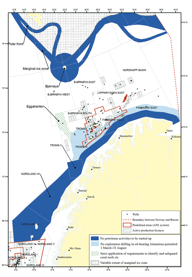
Figure 7.1 Framework for petroleum activities in the Barents Sea–Lofoten area.
Source Norwegian Petroleum Directorate
The north-eastern Norwegian Sea (Nordland I, III, IV, V, VI and VII, and Troms II)
There will be no petroleum activities in the open parts of Nordland VI during the current parliamentary period. Nor will any new blocks be announced during this period. The need to update the knowledge base for the opened areas will be considered in connection with the development of knowledge about the unopened areas.
No impact assessment will be carried out under the Petroleum Act for Nordland VII and Troms II or the unopened parts of Nordland IV, V and VI during the current parliamentary period.
The MAREANO programme is to complete the survey of the Nordland VI seabed in 2011, and then continue with the other areas that have not yet been mapped.
The SEAPOP programme will complete its survey of seabird populations and intensify monitoring in this area, and improve knowledge of how these populations are affected by human activity.
The Ministry of Petroleum and Energy will build up knowledge about potential impacts of petroleum activities in the unopened parts of Nordland IV, V, VI, VII and Troms II. This knowledge would be useful if it is decided to carry out an impact assessment of petroleum activities in these areas and as a basis for the next update of the management plan. This work will start soon.
It will examine the direct and spin-off effects on society and the business sector of such activities as tourism and fisheries. The topics for consideration will be decided in consultation with regional and local authorities, the authorities in the relevant sectors, and research institutions. It will also be necessary to strengthen knowledge about the petroleum resources in the unopened parts of Nordland IV and V through seismic surveys and the collection of other geological data under the auspices of the Norwegian Petroleum Directorate and in dialogue with the fisheries industry and the fisheries authorities. The Petroleum Directorate will collate this data and relevant seismic data from Nordland VI, VII and Troms II, and offer data packages for sale.
The Ministry of Trade and Industry, the Ministry of Fisheries and Coastal Affairs, the Ministry of Local Government and Regional Development and the Ministry of the Environment will develop knowledge of the direct and spin-off effects of expanding commercial activities such as tourism and fishery-related enterprises. The knowledge acquired will be useful for the next update of the management plan. This work will start soon. It will examine the spin-off effects on society and the business sector, and the topics for consideration will be decided in consultation with regional and local authorities.
The system of awards in pre-defined areas (APA) will be extended to include all the blocks in open parts of Nordland I, III, IV and V. This will apply from APA 2011. The environmental and fisheries-related requirements set out in the management plan for the Norwegian Sea will be applicable.
The Barents Sea
Previously disputed area west of the delimitation line
When the Treaty concerning Maritime Delimitation and Cooperation in the Barents Sea and the Arctic Ocean has been ratified by both Norway and Russia, the Government will initiate an impact assessment under the Petroleum Act, with a view to granting production licences for the previously disputed area west of the delimitation line in the southern part of the Barents Sea (south of 74°30’ N). If this is justified by the conclusions of the impact assessment, the Government will present a white paper recommending that these areas should be opened for petroleum activity.
The MAREANO programme will map the seabed in the previously disputed area west of the delimitation line, in accordance with the treaty on maritime delimitation between Norway and Russia.
Along the coast of Troms and Finnmark to the Russian border
No petroleum activities will be initiated in the current parliamentary period within a zone stretching 35 km outwards from the baseline from the Troms II petroleum province along the coast to the Russian border.
No exploration drilling will be permitted in oil-bearing formations in the zone 35–65 km from the baseline in the period 1 March–31 August.
Tromsøflaket bank area
The restrictions given in 2 b) for the coastal zone also apply to the Tromsøflaket.
No exploration drilling will be permitted in oil-bearing formations on the Tromsøflaket outside 65 km from the baseline in the period 1 March–31 August.
The Eggakanten area along the edge of the continental shelf
There is a general principle that new production licences must include requirements for surveys to identify any coral reefs or other valuable benthic communities that may be affected by petroleum activities and ensure that they are not damaged. This will be particularly strictly applied in the Eggakanten area. In vulnerable areas, special conditions may be included in licences to avoid damage.
The marginal ice zone and the polar front
No petroleum activities will be initiated in the areas along the edge of the marginal ice zone and the polar front in the current parliamentary period.
Bjørnøya
No petroleum activities will be initiated within a 65-km zone round Bjørnøya in the current parliamentary period.
Discharges to the sea
Discharges to the sea from petroleum activities will be regulated in the same way in the management plan area as on other parts of the Norwegian continental shelf.
Other environmental and fisheries-related requirements
The management plan will be used as a basis for determining environmental and fisheries-related requirements in new production licences. Until the next update of the management plan, no additional environmental and fisheries-related requirements will be introduced for petroleum activities in the Barents Sea–Lofoten area.
7.4 Measures to reduce pollution and marine litter
7.4.1 Preparedness and response to acute pollution
Since 2006, oil spill response technology and expertise has been further developed, and several steps have been taken to strengthen preparedness and response to acute pollution in the management plan area. Preparedness and response is evaluated regularly, for instance on the basis of lessons learned from accidents and government clean-up operations. Experience gained from the operation to deal with the Gulf of Mexico blowout in 2010 (discussed in Chapter 5.1.2 and 5.3) is also relevant in this context.
Legislative requirements and inspection and enforcement by the authorities play an important role for safety standards in the oil and gas industry. The operating companies are responsible for planning and command during oil spill response operations on the continental shelf. Through the Norwegian Clean Seas Association for Operating Companies (NOFO), an agreement with the Norwegian Coastal Administration on limited use of public resources has been adopted. A review is in progress of the need to elaborate some of the existing requirements for the preparedness and response that operating companies must maintain.
To provide an effective emergency response system, adequate vessel resources must be available for use during operations. Fishing vessels and other suitable vessels that are not primarily built as oil spill response vessels are an important resource in this context. To ensure crew safety, new regulations have been drawn up on the equipment and use of such vessels in operations to deal with acute pollution. Both the operating companies and the Norwegian Coastal Administration will conclude agreements with vessels to ensure rapid mobilisation in the event of an accident.
The availability of sufficient material and personnel is important for preparedness and response in coastal waters and along the shoreline. The effectiveness of different methods of dealing with oil spills, including mechanical recovery, the use of dispersants, in situ burning and various beach clean-up techniques, will be further evaluated and reviewed in the light of experience gained in the Gulf of Mexico.
Experience gained during oil spill response operations in Norway shows that operations management and close coordination between the actors involved is of crucial importance when dealing with acute pollution. The establishment of a national contingency plan system to further clarify the roles of public and private actors during operations is therefore important. The US experience of «unified command», an incident command system involving both competent authorities and the polluter, is relevant in this context. Incident command and the organisation of response operations will be improved by the introduction of a common response model for use in dealing with major incidents where the fire, civil defence and acute pollution authorities are all involved.
The Government will:
encourage the further development of technology for detecting and mapping acute pollution;
encourage the development of knowledge on chemical dispersants, to provide a better basis for assessing whether to use dispersants as a response method during government-run operations;
encourage the further development of knowledge on the effects of response measures and the weathering properties of relevant oil types as a basis for preparedness and response planning;
establish a national preparedness and response system and introduce unified command to improve coordination, understanding of the roles of different actors and incident command;
survey the personnel and other resources available for prolonged operations in the management plan area;
survey preparedness and response needs in coastal waters and the shore zone;
promote the further development of methods of oil recovery and beach clean-up for operations in Arctic conditions, and develop guidelines for beach clean-up operations;
look more closely at the requirements relating to the municipal response system and inspection and enforcement by the authorities;
develop response strategies and improve knowledge of the environmental impacts of in-situ burning, the use of dispersants and other response techniques.
7.4.2 Long-range transport of pollutants – international cooperation
Long-range transport of pollutants with air and ocean currents is the main source of pollution in the management plan area. Various organic pollutants released throughout the world are deposited in the Arctic, and changes in the levels of global releases can be detected in this region. Many of these substances are only slowly biodegradable and can therefore accumulate in living organisms and be concentrated along food chains. Impacts of such pollutants have been found in animals at the top trophic level of food chains in most of the Arctic. The immune system of a number of species, including polar bears, glaucous gulls, Arctic char and harp seals, has probably been weakened. Inputs to the Arctic of substances that were first used many years ago, such as PCBs and DDT, have been declining for a long time, but this positive trend has now stagnated. This could be because the substances are still in use in some areas, or it might be due to climate-related factors. In addition, new substances are constantly being detected in the Arctic environment. It often takes time to identify the environmental impacts of new substances, and it can be difficult to find suitable analytical methods. Norway has recently established an environmental specimen bank, which will play an important role by making it possible to re-analyse samples when new analytical methods are developed or new pollutants are identified. The samples stored here will also be important for the establishment of reference and background levels for new pollutants.
Long-range transport of pollutants is one of the key challenges that must be addressed to maintain the Barents Sea as a clean and rich sea.
The Government will:
ensure that efforts to reduce the use and discharge of hazardous substances are given high priority in development cooperation and in cooperation with Russia;
play an active part in work under international agreements, including the global Stockholm Convention on Persistent Organic Pollutants and the regional Convention on Long-Range Transboundary Air Pollution, and in ensuring strict regulation and the inclusion of more substances;
give priority to the negotiation of a global instrument on mercury under the United Nations Environment Programme (UNEP);
carry out surveys and screening studies to identify new pollutants in the Arctic;
ensure that samples from studies in the management plan area are stored in the environmental specimen bank.
7.4.3 Marine litter
Marine litter is a problem that has attracted a great deal of attention internationally.
Within the framework of cooperation under the Convention for the Protection of the Marine Environment of the North-East Atlantic (the OSPAR Convention), the goal is to «substantially reduce marine litter in the OSPAR maritime area to levels where properties and quantities of marine litter do not cause harm to the coastal and marine environment». To achieve this, the parties to the OSPAR Convention have agreed on a series of measures. A pilot project to monitor marine litter on beaches in selected countries has had positive results, and OSPAR is now planning to establish a coordinated monitoring programme for marine beached litter by 2014.
A report on the scale and impacts of marine litter in Norwegian coastal and marine areas was published by the Climate and Pollution Agency and the Directorate for Nature Management in February 2011. This concludes that we currently have only limited knowledge about the exact scale and sources of marine litter in Norway, but that we nevertheless know enough to establish that this is a serious environmental problem in Norwegian waters as well. Much of our knowledge comes from beach litter surveys, studies of seabird stomachs, video images of the seabed and studies of microplastics in the Skagerrak. The report also proposes measures to reduce the problem.
A system of reference beaches where beach litter is regularly monitored should be established. Tromsø municipality has received a grant for a pilot project, which was carried out in 2010. This is the first time a survey of this kind has been carried out in Norway, and it is expected to provide useful experience for further efforts to combat marine litter.
The Government will:
survey the scale of the marine litter problem in the management plan area and its impacts, and consider action to deal with it;
monitor beached litter in selected areas;
carry out a project to evaluate waste streams (types and amounts) from ships to land-based reception facilities.
7.5 Strengthening the knowledge base
7.5.1 Mapping the seabed
The MAREANO programme maps depth and topography, sediment conditions, habitats and pollutants in Norwegian waters. The seabed surveys generate a great deal of new information on the distribution of habitats and species and on the pressures due to human activity. This can be used to improve the management regime and provide better protection for vulnerable habitat types. Criteria for setting priorities for future work have been further developed. In further mapping of the Barents and Norwegian Seas, the Government is giving priority to areas where there are or may be important species and habitat types or natural resources that may be affected by existing or new human activities.
The Government will:
continue the MAREANO programme for mapping of the seabed in Norwegian waters.
7.5.2 Mapping and monitoring seabird populations
SEAPOP is a mapping and monitoring programme for seabird populations in Norwegian waters. Its purpose is to obtain and maintain baseline information on seabirds and thus help to improve management of the marine environment. It focuses particularly on the collection of data that make it possible to model the effects of human activity and distinguish between these and natural variations. This will make it possible to improve the management and protection of seabirds. It is important to continue knowledge development through programmes that investigate such causal relationships.
The Government will:
intensify mapping and monitoring of seabirds in Norwegian waters, along the coast and in Svalbard and Jan Mayen through the SEAPOP programme.
7.5.3 Mapping and monitoring pollution
The coordinated monitoring programme for the Barents Sea–Lofoten area has provided a better overview of the pollution status of the management plan area. The established monitoring programmes for pollutants are important in building up knowledge about pollution and hazardous substances in Norwegian seas and seafood. Such knowledge is needed both for management of ecosystems and species and to make it possible to document that consumption of seafood from Norwegian waters is safe.
The Government will:
further develop pollution monitoring programmes;
continue to map and monitor contaminants in marine species.
7.5.4 Climate change and ocean acidification
Climate change and ocean acidification are the most serious challenges that will have to be addressed in the time ahead. Ocean acidification may have major impacts on ecosystems at our latitudes. It is therefore of crucial importance to obtain more information on trends in acidification and the impacts of acidification on individual species, on biodiversity and on the biological availability and uptake of hazardous substances. More knowledge is also needed about the synergistic effects of interactions between ocean acidification and climate change.
To meet these needs, it will be essential to put in place a long-term programme with adequate coverage to monitor changes in ocean acidity and the impacts of these changes. This is needed both to gain an overview of the scale of the problem and to provide projections of future trends.
New challenges will arise as regards the management of previously ice-covered areas that become ice-free as a result of climate change. The Government will address these challenges by obtaining the necessary knowledge before new activities are initiated in such areas.
The Government will:
intensify monitoring of ocean acidification and climate change;
build up knowledge of the pace and impacts of climate change, which processes create irreversible change, how resilient the Barents Sea–Lofoten area is to change, the impacts of ocean acidification on marine ecosystems, and how these developments contribute to the cumulative environmental effects on ecosystems;
intensify knowledge development on the impacts of ocean acidification and climate change, focusing on developing and using good impact indicators;
ensure that adequate knowledge on ecosystems and ecological goods and services is obtained before new activities are initiated in previously ice-covered areas.
7.5.5 Synergistic effects of interactions between pollutants, climate change and ocean acidification
There is little information available on the synergistic effects of interactions between hazardous substances or between hazardous substances and other factors such as ocean acidification and climate change. The latter will be a key topic in future work, and is an area where there is an urgent need for knowledge.
The Government will:
take steps to generate knowledge on the ecological relationships between different parts of marine ecosystems;
develop more knowledge on the cumulative environmental effects of different environmental pressures (such as climate change, ocean acidification and hazardous substances) and human activities (including fisheries, shipping, oil and gas activities);
ensure that knowledge is developed on the synergistic effects of interactions between ocean acidification, climate change and pollutants;
develop knowledge on the synergistic effects of interactions between different hazardous substances.
7.5.6 Environmental risk analysis
Further work is needed on the development of criteria for selecting scenarios to be used in environmental risk analysis of potential oil spills.
The knowledge base on the consequences of oil spills for fish stocks has been further developed, and data on several factors that determine environmental impacts and environmental risk have been updated. However, the methods for analysing the environmental consequences and environmental risk of acute oil pollution for fish, seabirds, marine mammals and beaches need to be further developed and improved. Work should be continued on developing methods of calculating the loss of recruitment to year classes of fish that handle spatial variations in survival from larvae to adult fish in a biologically sound way. More precise knowledge of annual variations in migration paths and spawning areas has been mentioned as one factor that could reduce the uncertainty of environmental risk analysis.
The Government will:
ensure that knowledge development in the field of environmental risk is continued.
7.5.7 Development of indicators
So far, most of the indicators that have been developed tell us something about the state of the ecosystem, for example about population sizes or the distribution and concentrations of hazardous substances in marine animals and plants. Knowledge of the state of the environment has not been linked to any great extent to the pressures on the ecosystem and the impacts these have on different components of the ecosystem. To develop a more complete indicator set, an initiative to develop pressure and impact indicators is proposed. The development of biological effect monitoring is a key part of cooperation under the OSPAR Convention, and is expected to generate new knowledge that will be useful in developing biological effect monitoring in Norwegian sea areas. An indicator set that includes pressure and impact indicators as well as state indicators will improve the evaluation of targets. It is also important to ensure that changes registered through the environmental monitoring system are followed up by appropriate action if the indicator values indicate deviations from the desired state.
The Government will:
continue the work of developing representative indicators, reference values and action thresholds for the monitoring system under the management plan;
develop impact and pressure indicators that can also be used to assess progress towards targets;
ensure that if action thresholds for indicators are exceeded, this elicits an assessment of the appropriate action to take.
7.5.8 Cooperation with Russia on the marine environment – establishing a basis for an integrated Norwegian-Russian environmental monitoring programme for the Barents Sea
Cooperation on the marine environment is the most important element of environmental cooperation between Norway and Russia, and is intended to play a part in protection of the marine environment of the Barents Sea.
An increase in environmental pressures in the Barents Sea is expected, particularly in connection with the expansion of oil and gas activities, fisheries and maritime transport. The impacts of both climate change and ocean acidification may increase. The cumulative environmental effects may be substantial, which will increase the need for Norway and Russia to coordinate their efforts. Within the framework of Norwegian-Russian cooperation on the marine environment, work is now in progress on establishing a basis for an integrated Norwegian-Russian monitoring programme for the entire Barents Sea. This will be based on the joint Norwegian-Russian environmental status report for the Barents Sea, which was presented in 2009. An integrated environmental monitoring programme would put the authorities in the two countries in a better position to meet the needs and challenges involved in making the transition to an integrated, ecosystem-based monitoring system for the Barents Sea. An integrated monitoring programme for the Barents Sea will be a natural continuation of Norway’s work with management plans for its sea areas. It can also make a valuable contribution to the formulation of a corresponding plan for the Russian part of the Barents Sea. The Government intends to further develop its cooperation with Russia on the marine environment, and will focus on developing the necessary knowledge base and an integrated and as far as possible joint approach to sound management of the Barents Sea.
The Government will:
cooperate with Russia on the establishment of an integrated Norwegian-Russian monitoring programme for the Barents Sea, particularly with the aim of assisting in the development of a Russian management plan for the Russian part of the Barents Sea.
7.5.9 Dissemination activity
The website miljøstatus.no is a national channel for dissemination of environmental information. Steps have recently been taken to ensure that the information it provides on marine management is tailored to user needs. The website is the joint responsibility of the environmental authorities, and the Climate and Pollution Agency has the overall editorial responsibility. For the topic «marine and inland waters», special cooperation agreements have been drawn up with the Institute of Marine Research, the Norwegian Coastal Administration and the Geological Survey of Norway. These enable important actors to upload information directly to miljøstatus.no. Close cooperation has been established as a basis for providing comprehensive information on work on the management plans.
The Government will:
disseminate information on the management plans and their development on the website www.miljøstatus.no and in other ways.