4 Activities, management and value creation in the Barents Sea–Lofoten area
This chapter describes and evaluates the most important industries in the Barents Sea–Lofoten area, in terms of both the value creation and benefits to society they represent, and the pressures and impacts they exert on the environment. Section 4.9 deals in particular with value creation and social benefits related to the waters off the Lofoten and Vesterålen Islands and Senja.
The most important industries in the Barents Sea–Lofoten area today are fisheries, maritime transport and petroleum activities, but other industries, such as tourism, marine bioprospecting and possible future developments in offshore energy and prospecting for minerals on the seabed, are included in this white paper as well. The importance of marine ecosystem services for value creation and Norwegian society is also discussed.
4.1 Fisheries and aquaculture
4.1.1 Trends in fisheries management
At present the major fish stocks in the Barents Sea are in good condition and are harvested within safe biological limits. They are managed in accordance with the principles set out in the Marine Resources Act and in line with the management objectives of the Nature Diversity Act. Cooperation with the Russian fisheries management authorities is extremely important for ensuring the sustainability of harvesting in the Barents Sea. Over the last 10 years the fisheries authorities have made very successful efforts at the national and international level to reduce the illegal, unreported and unregulated fishing (IUU fishing) of cod in these sea areas, and in 2009 no incidents of IUU fishing of cod and haddock were detected. This was the result of close cooperation between the Norwegian and Russian authorities and of the development of new control mechanisms such as the port state control system under the North East Atlantic Fisheries Commission (NEAFC). Control of resources and a harvesting level in line with the quotas that are set are essential for maintaining a sustainable management regime.
Satellite tracking is an important part of Norwegian resource monitoring. All Norwegian fishing vessels with a length of more than 15 m are required to have a tracking device installed on board that automatically transmits data, regardless of where they are. The same applies to foreign vessels operating in Norwegian waters.
Much work is being done on the international rules for bottom fisheries with a view to safeguarding biodiversity, and in Norway there are new regulations relating to bottom fisheries. In addition new fishing gear is continually being developed that reduces the impact of fisheries on the seabed. For example new trawling methods are being developed that reduce the impact on benthic habitats and at the same time reduce fuel consumption and NOx emissions. An important factor in this connection is that the extent of bottom trawling declined from 2005 to 2009.
Textbox 4.1 Regulation of fisheries in the Barents Sea–Lofoten area
General prohibition on trawling in areas less than 12 nautical miles from the baselines
There is a general prohibition on trawl fishing off the Norwegian mainland in areas less than 12 nautical miles from the baselines. However, there are exceptions to this rule that permit fisheries in areas to within 6 nautical miles of the baselines. The prohibition does not apply to trawling for kelp or Norway lobster, or shrimp trawls without bobbins or rockhopper gear.
Trawl-free zones and flexible areas
In order to protect larvae and vulnerable areas, a number of trawl-free zones (permanently closed to trawling for all or part of the year) and flexible areas outside the 12-mile limit have been established under the Regulations relating to sea-water fisheries. These provisions have also promoted the sharing of sea areas to avoid gear conflicts.
The term «flexible areas» is used to mean delimited areas where fishing is regulated during specific periods by means of restrictions on or a prohibition on fishing with particular gear in the whole area or certain parts of it. In such areas, the number of vessels participating in the fishery may also be limited.
Coastal shrimp trawling
Coastal shrimp trawling is carried out in both the northern and the southern parts of the management plan area. This is conducted in certain particular areas by smaller vessels using lighter gear, and there is no reason to believe that this activity causes significant damage to vulnerable benthic habitats. This type of fishery is strictly regulated by local regulations for different stretches of the coastline.
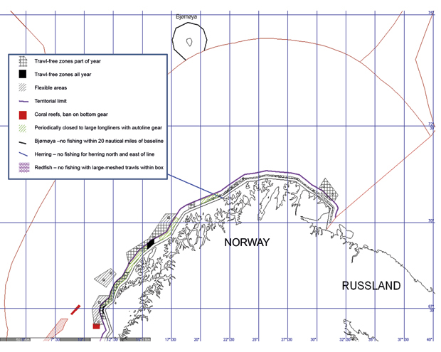
Figure 4.1 Trawl-free zones and flexible areas in the Barents Sea
Source Directorate of Fisheries
4.1.2 Activities
The most important fisheries in the sea areas from the Lofoten Islands northwards along the coast up to and including the Barents Sea have always been for Norwegian spring-spawning herring, Northeast Arctic cod, Northeast Arctic haddock, Northeast Arctic saithe, and capelin. Generally speaking stocks have increased over the last 10 years, especially cod and haddock, and quotas have increased accordingly. In 2011 the Norwegian quota for cod was 319 000 tonnes, for haddock 148 000 tonnes, for saithe 173 000 tonnes, for Norwegian spring-spawning herring 602 680 tonnes and for capelin 275 000 tonnes.
For some years, Norwegian vessels mainly fished for Norwegian spring-spawning herring in the Vestfjorden area. However, in 2003 the migration pattern of the herring changed, and the younger year classes began to overwinter on the bank areas and in the waters west of the Lofoten and Vesterålen Islands and southern Troms. At the same time the stock increased substantially. In the last few years there has been very little herring in southern Troms. The new migration pattern also means that more seine fishing and trawling is carried out in these areas than previously.
The traditional spawning-season cod fishery in the Vestfjorden area from February to April is now substantially reduced because the migration pattern of the cod has changed. In recent years spawning has begun to take place further out, around the Lofoten Islands as far as Røst, northwards around the Vesterålen Islands and as far north as western Finnmark. This more northerly distribution is not entirely new, since it also occurred in the period 1930–50. Fishing vessels that normally used to fish in the Vestfjorden area have transferred their activities westwards and northwards along the coast.
Changes in the structure of the fishing fleet and fishing grounds
In 2009, 1.17 million tonnes fish were landed in the three northernmost counties, and the structure of the fisheries has been gradually rationalised. The number of vessels has been reduced, which has increased productivity and profitability since it means that the total catch is divided between fewer vessels. The total catch has remained relatively stable from year to year, and any fluctuations have primarily been due to biological variations. There are variations in the migration patterns of Northeast Arctic cod and spring-spawning herring from year to year and over time, which means that fisheries move from one area to another, and it is not always possible to know beforehand where fisheries activity will be highest.
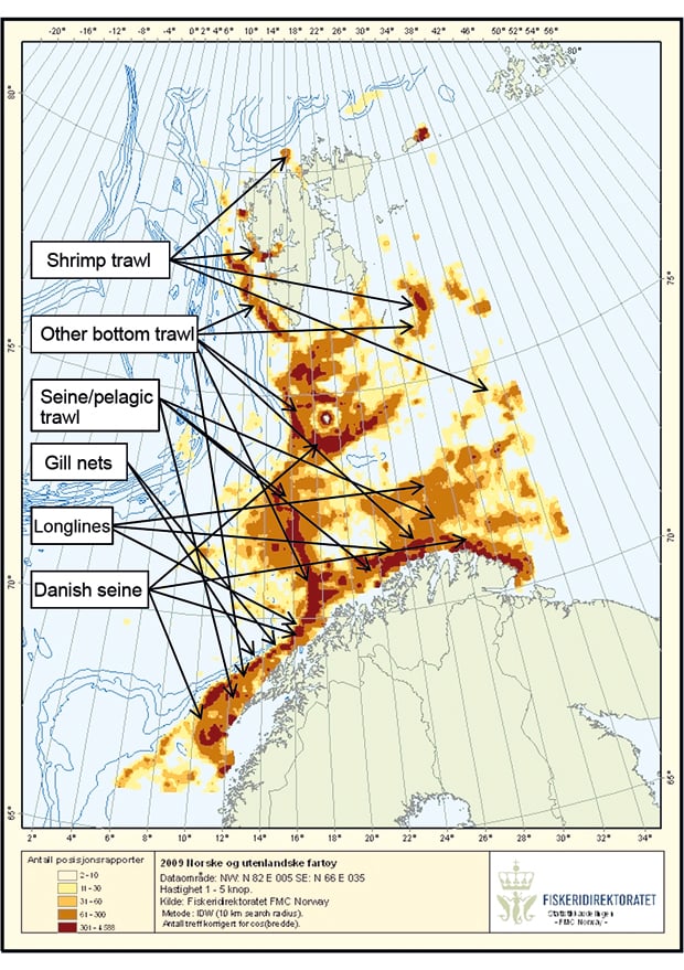
Figure 4.2 Fishing vessel activity for vessels with a length of more than 21 m in 2009. The dark shading shows the greatest activity.
Source Directorate of Fisheries
4.1.3 The importance of fisheries and aquaculture for value creation and Norwegian society
On the basis of figures from Statistics Norway and Nofima, the direct commercial importance of fishing and aquaculture for Norway as a whole, measured in terms of its contribution to GDP, was estimated at NOK 18 billion in 2009. Furthermore, in addition to the core activities (fishing, aquaculture, fish processing and wholesaling), fishing and aquaculture have spin-off effects in other sectors. These include employment in technological sectors, for example jobs in local shipbuilding companies or with suppliers of various types of technical equipment. According to the SINTEF Group, in 2008 every krone generated by core activities in the fisheries and aquaculture sector resulted in NOK 0.96 in value creation in other sectors, which means that the value creation in core activities alone had almost doubled.
The total export value of the fishing and aquaculture industry was NOK 44.7 billion in 2009 and NOK 53.8 billion in 2010.
The sector accounts for just under 5 % (around 11 000 persons) of employment in North Norway. In addition it generates a considerable number of jobs in for example the supply, fish processing and transport industries. There are strong links between settlement and access to marine resources in the fisheries sector, but the importance of the sector varies considerably within the region. On some of the islands, such as Træna, Røst, Værøy and Moskenes, the fisheries industry accounts for over 40 % of total employment.
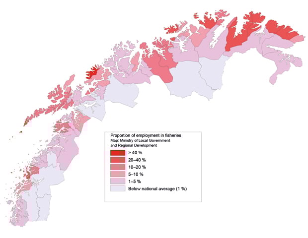
Figure 4.3 Employment in the fisheries sector in North Norway, as a percentage of total employment.
Source Statistics Norway and the Panda Group
Fisheries
According to figures from Statistics Norway, the total landed value of the catch in the Barents Sea–Lofoten area was NOK 6.3 billion in 2009, or 56 % of the total landed value for Norwegian fishing vessels in the same year.
The total catch in the management plan area rose from approximately 750 000 tonnes in 2000 to over 800 000 tonnes in 2009. In the last few decades Norwegian fisheries have developed from a relatively unregulated industry to a strictly regulated one, subject to quotas and licensing requirements. All our most important fish stocks are shared with other nations, which means that international cooperation is vital for the Norwegian management system. Due to sound and sustainable resource management, it has been possible to increase the quotas in the last few years. The coastal fishing fleet plays a vital role in the Barents Sea–Lofoten area, and accounts for just over 40 % of the landed value. In the coastal municipalities from the Lofoten Islands to Norway’s border with Russia, fishing is a full-time occupation for 4 900 persons and a part-time occupation for 1 300. In the same area 90 % of the 3 650 registered fishing vessels are small vessels less than 15 m total length. These vessels generally fish in waters close to home, are less mobile than larger vessels and are used mainly to fish cod. In a number of small communities the fleet of small vessels accounts for a large percentage of employment, and there are few employment alternatives.
Aquaculture
The aquaculture industry operates inside the baselines and thus outside the management plan area. However, the industry is likely to be affected by the general state of the environment and by any accidents in the Barents Sea–Lofoten area.
About one-third of aquaculture production in Norway takes place in North Norway. In 2009, 280 000 tonnes of salmon, 23 000 tonnes of trout, 11 500 tonnes of cod, around 500 tonnes of other marine species and 500 tonnes of shellfish were produced in the three northernmost counties. The landed value in these three counties was NOK 7.5 billion in 2009, most of which was exported. The industry alone generated around 1 600 jobs in North Norway in 2009.
There has been substantial growth in aquaculture production in Troms and Nordland in recent years. In Troms it has doubled since 2005 and in Nordland it has increased by 35 %. Production in Finnmark has been stable. There are large accessible areas of coastline in North Norway, which means that there is great potential for further development of this industry in the region. In the 2009 allocation round, about half of the 65 new licences were granted for salmon, trout and rainbow trout farms in North Norway. In addition the Government permitted a production increase of up to 5 % for salmon and trout farms in Troms and Finnmark in 2011.
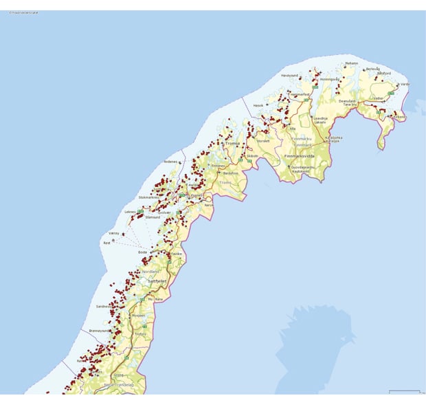
Figure 4.4 Aquaculture sites in North Norway
Source Directorate of Fisheries/Norway Digital
Safe seafood – the importance of a good reputation
Value creation in the seafood industry depends on ensuring that Norwegian seafood products are safe to eat and have a high national and international reputation. Transparency and information are also important. To ensure this, the authorities should have a monitoring system for:
levels of known hazardous substances in seafood,
parasites that reduce seafood quality or that may cause disease in humans,
naturally occurring toxins in shellfish,
hygiene indicators,
screening for new hazardous substances.
Such knowledge helps to ensure that Norwegian seafood is safe to eat and preserves its high reputation in markets at home and abroad. At present monitoring of contaminants in wild fish stocks is conducted through baseline studies and sampling, and by mapping contaminants in fish feed and farmed fish.
Another factor that contributes to the high reputation of seafood is that Norway follows international rules in the field of food safety, and effectively monitors compliance by the industry. The Norwegian Food Safety Authority has a variety of measures it can call on when violations of the rules are detected, and increases the severity of the measures taken in the event of serious and repeated violations.
In the event of an accident resulting in pollution that could compromise seafood safety, the authorities must be able to monitor and control seafood safety in the area concerned. Previous experience of oil spills and of cases where a product has attracted negative attention has shown that in the short term it is difficult to sell products from the polluted area, including those that are obviously not contaminated and even products from other industries with links to the area. However, no clear impacts on prices have been found over the long term.
Future developments in value creation
Climate change, new developments affecting the resource base, new technology and new framework conditions will all have impacts on future commercial activity based on marine resources. The most important fish stocks in the Barents Sea are in good condition and the fisheries management regime is effective. However, natural migration and other factors cause the composition and size of stocks to vary. The impacts of climate change are uncertain, for example with regard to ocean acidification, and it is difficult to predict how this will affect the growing conditions for farmed fish. It is also possible that the composition of wild fish stocks will be altered and that this will have consequences for the fisheries. However, this is very uncertain.
Environmental sustainability, competing uses of the same area and the state of the market influence the growth and development of the seafood industry. If the current trend continues, employment and value creation in the industry will increase. The structure of the fisheries has been undergoing gradual rationalisation for a long time. The number of vessels has been reduced and this has increased productivity and profitability. If the present trend in the management regime continues, employment in the fisheries industry will gradually decline and value creation will increase over the long term.
Taken together, these factors indicate that value creation in the fisheries and aquaculture sector will increase in the period up to 2025.
4.1.4 Evaluation of the pressures and impacts associated with the fisheries
The fisheries represent a considerable pressure on the ecosystems in the Barents Sea–Lofoten area. Harvesting a fish stock is bound to have an effect on it, and under normal circumstances is the most important anthropogenic pressure. However, an ecosystem is in a constant state of flux due to variations in natural conditions such as predation, migration (in response to changes in temperature and food supply) and disease. Sustainable management of fish stocks means that it is the surplus production of the stock that is harvested. At present the harvest of the most important commercial fish stocks (capelin, herring and cod) is within safe biological limits, but fishing pressure is considered to be too high for certain smaller stocks such as blue ling, golden redfish and beaked redfish. Steps are still being taken to rebuild these stocks, and new measures are considered annually.
More thorough mapping of the seabed in recent years has shown that fisheries activity, especially bottom trawling, has had greater impacts on benthic ecosystems than was previously believed. In this connection the Institute of Marine Research has conducted a number of experiments with pelagic trawls and surveyed the impacts of different types of trawls on different benthic habitats. The results have provided new knowledge that can be used to further develop pelagic trawls and to design gear that exerts less pressure on benthic ecosystems.
There is considerable fisheries activity in the Tromsøflaket area, and as one would expect, there is relatively serious damage to coral reefs and sponge communities. Fisheries have also been shown to have impacts along the edge of the continental shelf and in some places at greater depths in Nordland VII. MAREANO surveys conducted along the edge of the continental shelf have shown that trawl tracks are very common; they were found in 51 of the 76 localities investigated. In the areas with the greatest density of tracks, 42 tracks per km seabed were found, or one track for every 25 m. Very few traces of human activity other than fisheries have been detected. To summarise, in the localities investigated about two of 10 coral reefs had suffered damage to a greater or lesser extent and about 6 % of all investigated reefs in the management plan area had been destroyed. There is considerably less trawling that there was a few decades ago, and many of the observed instances of damage go back many years.
Locally, areas that have been trawled repeatedly over time will be populated by opportunist, short-lived species. Recolonisation and recovery are affected, and such areas tend to remain at an early successional stage. In the long term this could result in permanent changes. In areas that have been bottom trawled it is often only possible to find small specimens of sponges.
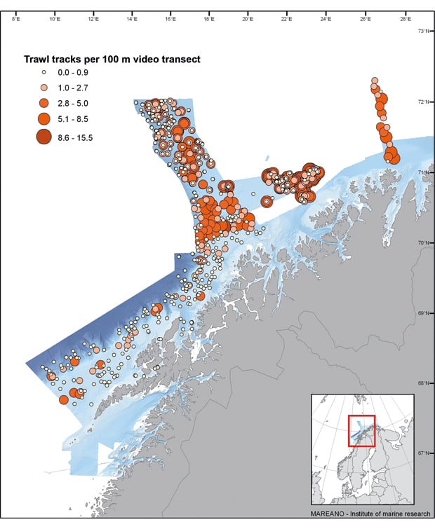
Figure 4.5 Density of trawl tracks on the seabed in areas mapped by MAREANO up to the 2009/2010 season.
Source MAREANO/Institute of Marine Research
Fisheries also put pressure on seabirds and marine mammals, in the form of impacts on food supplies, unintentional bycatches in fishing gear and marine litter from fishing vessels. Our knowledge of the scale of unintentional bycatches of seabirds and marine mammals is limited, and studies are being conducted. As from 2011, bycatches of seabirds and marine mammals have to be included in the information recorded in electronic catch logbooks. No changes have been registered for the impact on seabirds, but for marine mammals in general bycatches have declined, although as a result of greater knowledge the estimated figures for bycatches of common porpoise in certain areas have risen.
4.2 Shipping
A number of measures have been implemented to strengthen maritime safety and governmental preparedness and response to acute pollution, including further development of knowledge and technology and measures to reduce the probability of accidents. This subject is discussed in more detail in Chapter 5 in the section on risk. In the present chapter, value creation by shipping and the pressures exerted by normal operations are discussed.
4.2.1 Activities
Trends in maritime traffic 2005–09
The volume of traffic of seismic survey vessels, offshore supply vessels and tankers has shown a considerably greater increase than that of other vessel types, but from relatively low levels. Tanker size has also increased. In 2008 fishing vessels accounted for the largest number of ship movements and about 58 % of the total distance sailed in the management plan area.
More than 80 % of the total distance sailed in the Barents Sea–Lofoten area by vessels of gross tonnage over 10 000 now lies within the areas covered by the traffic separation schemes between Vardø and Røst, and this includes almost 100 % of all tanker traffic. The remaining traffic in the area is dominated by cargo vessels of gross tonnage 1 000–5 000, but there is also some traffic of other cargo vessels and offshore and other service vessels.
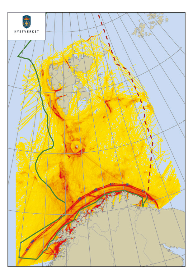
Figure 4.6 Traffic density in the management plan area, the traffic separation schemes between Vardø and Røst (thick red line) and nearcoast areas in the second half of 2010. The highest traffic density is indicated by the red shading.
Source National Coastal Administration
The transit traffic consists of large tankers and bulk carriers sailing to and from Russian ports. Up to 2008, the volume of traffic was relatively stable in terms of both cargo volume and number of ships. The cargo volume was an estimated 10–12 million tonnes per year, carried on 200–240 fully loaded ships. However, in 2009, the volume rose considerably (see Figure 4.7). There are many indications that transit cargo volume will continue to rise in the years ahead. The average size of oil tankers is also expected to rise.
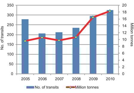
Figure 4.7 Numbers of vessel transits by fully loaded tankers, and millions of tonnes of oil and petroleum products transported along the Norwegian coast from northwestern Russia
Source Norwegian Defence Forces
The volume of maritime traffic to and around Svalbard has fluctuated over the last 10 years. The traffic consists of large foreign cruise ships, expedition vessels, goods traffic, research vessels, fisheries traffic along the coast and in certain fjords, and transport of coal mined in Svalbard.
Ship-to-ship transfers of Russian crude oil take place in winter in the Bøkfjorden at Kirkenes and in the Sarnesfjorden at Honningsvåg. During the winters of 2005/06–2008/09 there were an average of nine transfers each winter, but there have been none during the last two winters (2009/10 and 2010/11). This activity alters the local level of risk because it means that the tankers sail closer to land. There are special emergency preparedness requirements for ship-to-ship transfers.
The number of calls at the largest ports relevant to the management plan area has declined somewhat since the peak year 2005. The volume of goods for different ports in the region fluctuates and does not correspond to the trends in the number of calls. Narvik is still much the largest port, and the volume of goods consists almost entirely of iron ore transports from the mining company LKAB. Development of the Snøhvit field has resulted in a large increase in goods transports to and from Hammerfest.
Projected trends in maritime traffic up to 2025
There is less activity in the Barents Sea–Lofoten area than in the sea areas further south. Projections for the area indicate a small increase (about 3 %) in the total distance sailed in the period 2008–25 and a general increase in the distance sailed for most types of ships (see Figure 4.8), with most of the increase occurring towards the end of the period. For fishing vessels, on the other hand, a marked decrease in the distance sailed is expected. In 2008 fishing vessels accounted for around 58 % of total distance sailed in the area, while in 2025 the figure is expected to be around 50 %. Tanker activity in the area is likely to increase by more than 100 %, especially for large oil and gas tankers.
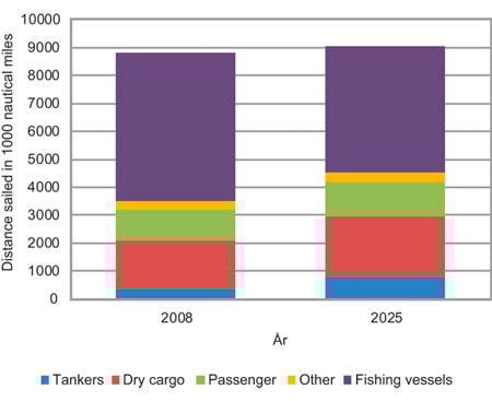
Figure 4.8 Projected trends in distance sailed for various types of ships in the period 2008–25
Source National Coastal Administration
Projected maritime traffic across the Arctic Ocean during ice-free periods
The rapid ice-melt in the last few years has led to increased interest in maritime traffic across the Arctic Ocean, including the Northeast Passage. The Arctic summer ice is retreating so rapidly that in periods all or part of the traffic lanes north of Russia and Canada/the US are open until the ice re-forms. The ice-melt also means that increasing areas of the Arctic Basin are covered by first-year ice, which is thinner, making it easier for ships to force their way through. At present the volume of traffic in the Arctic Ocean itself is small and ships with destinations in the area are expected to continue to dominate maritime traffic for the next few years.
As a follow-up to its 2009 report, the Arctic Marine Shipping Assessment, the Arctic Council’s working group on the Protection of the Arctic Marine Environment (PAME) is now considering which sea areas in the Arctic are likely to require special protection against the environmental impacts of future maritime traffic across the Arctic Ocean. The group’s conclusions will form the basis for the Norwegian authorities’ assessment of the need for measures to strengthen maritime safety, such as proposals to the International Maritime Organization (IMO) for new sea areas that should be designated as Special Areas or Particularly Sensitive Sea Areas (PSSA).
4.2.2 Importance of maritime transport for value creation and Norwegian society
Maritime transport is important for coastal communities in the management plan area since the largest proportion of goods and passengers within the region is transported by ship. However, the domestic and international maritime transport industry accounts for less than 2 % (3 700 persons) of employment in the three northernmost counties. The Government’s goal is for a larger share of goods transport to be transferred to water.
At the national level, the maritime industry is a large and important sector that employs around 100 000 persons and resulted in value creation of NOK 85 billion in 2008. The figures for the management plan area have become more reliable since 2006. In North Norway and Nord-Trøndelag there are around 700 businesses related to the maritime industry, with about 10 000 employees and a total turnover of around NOK 15 billion (2007). The fisheries industry accounts for 25 % of employment. Value creation in Nordland amounts to NOK 3 billion, in Finnmark just under NOK 1 billion and in Troms approximately the same. Subcontractors include about 40 operative shipyards in North Norway. These deal with modification and maintenance, especially for the fishing fleet and high-speed and other ferries.
The maritime industry in North Norway is built on two cornerstones. These are the fisheries, which encompass a wide range of large and small vessels, and coastal passenger transport under contract to the state sector. There are 150–200 shipowners in the local transport and cruise traffic sector, mostly small businesses but also a number of major companies such as Torghatten trafikkselskap, Veolia Nord and Hurtigruten. The Coast Guard is another important actor. Shipowners form a larger proportion of the maritime industry in North Norway than in the rest of the country.
There has been a marked shift from international to domestic maritime transport (see Figure 4.9). The decline in the number of Norwegian seamen employed in international shipping is related to changes in the conditions of competition and the use of foreign seamen. The increase in the number of persons employed in domestic shipping is related to the decline in those employed in the fisheries sector. This is due to the better employment conditions in the domestic maritime transport sector, where the wages are higher due to the tax refund scheme for seafarers.
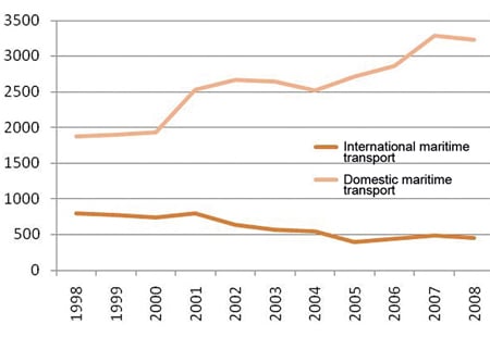
Figure 4.9 Employment in maritime transport in North Norway, 1998–2008
Source Statistics Norway and the Panda Group
Projected trends up to 2025
Developments in maritime transport in the management plan area will affect the demand for other goods and services, for example for port services. Maritime traffic passing through the area is not expected to influence value creation or social conditions to any great extent. Projections for the effects of petroleum activities on the demand for maritime transport and services up to 2025 are uncertain. Petroleum activities in a sea area increase the need for maritime transport, and experience from other areas on the Norwegian continental shelf indicates that these activities increase the demand for services that require supply ships, which in turn will require greater resources and capacity on land.
4.2.3 Evaluation of the pressures and impacts associated with maritime traffic
Shipping may have negative environmental impacts in the management plan area through spills of petroleum products and other chemicals, operational discharges to water and air, releases of pollutants from anti-fouling systems, noise, the introduction of alien species via ballast water or attached to hulls, and local discharges from zinc anodes in ballast tanks. In spite of this, ships are on the whole a relatively green form of transport.
The traffic separation schemes between Vardø and Røst have significantly reduced the risk of ship accidents in this sea area. The government emergency tugboat service, together with traffic surveillance by the Vardø vessel traffic service centre, has also helped to reduce the risk. The risk of acute pollution from ships, and preventive measures to enhance safety at sea are discussed in Chapter 5.1.1.
Operational releases from ships have been estimated on the basis of the volume of traffic in 2008 and projections for 2025. CO2 emissions are expected to increase as a result of the larger number of ships with larger engines, while NOx and SOx emissions are expected to decrease as a result of new rules and technological developments. However, it is not possible to quantify operational discharges to the sea or to calculate their impacts.
Maritime transport can result in the unintentional introduction of alien species into the ecosystems of the management plan area. The risk will increase with the growth in ship traffic, especially traffic from areas with a similar marine climate. A warmer climate could increase the likelihood that species introduced from further south will be able to establish themselves in Norwegian waters, and if the Northeast Passage is opened for traffic, this may increase the risk of introductions from more distant areas with a similar marine climate.
The impacts of maritime transport on seabirds are related to discharges of oil and litter. Illegal operational discharges from ships may result in oil on the surface, leading to higher mortality in adult seabirds. We know that small quantities of oil are discharged illegally, but not to what extent. It is not possible at present to quantify operational discharges of this kind or to calculate their impacts. Although littering by ships has been banned since 1998, plastic waste is still being found in the marine environment. It seems likely that illegally discarded marine litter, particularly plastic objects and particles, has negative impacts on many species in the management plan area. Marine litter is harmful to species that feed on the sea surface such as black-legged kittiwake, fulmar and marine mammals because they can become entangled in the waste or eat the plastic, which can injure the digestive organs. No changes have been registered in the level of impact from marine litter since 2006.
Noise, especially from propellers, has now been discovered to be a greater problem for marine mammals that was previously believed. Apart from major spills of chemicals and petroleum products, no negative impacts from shipping on fish stocks and seafood are known or documented.
The possibility of a greater volume of maritime traffic in the Arctic Ocean, much of which will be sailing through Norwegian sea areas, is attracting considerable attention. In the Barents Sea, the volume of Russian oil transports has risen since 2006, and in the next few years this type of traffic, which is based on transport of resources from the Arctic, will increase in the peripheral seas of the Arctic Ocean. There is already some intercontinental transit traffic, and if the routes across the Arctic Ocean become more profitable than land transport and other sea routes, and if they are considered sufficiently reliable and safe, this type of traffic could increase.
4.3 Petroleum activity
4.3.1 Current framework
Seismic surveys and exploration drilling for oil and gas began in the Barents Sea in 1980. Parts of the Tromsøflaket (in Troms I) were opened for petroleum activity in 1979 and further areas in the southern part of the Barents Sea were opened in the first half of the 1980s (Bjørnøya South, Troms I Northwest and the northern part of Finnmark West). The southern part of the Barents Sea was formally opened for exploration in 1989 (Report No. 40 (1988–1989) to the Storting) on the basis of an impact assessment of the area. The assessment concluded that Troms II should not be opened.
In 2001 all petroleum activities in the Barents Sea apart from the development of the Snøhvit field were suspended pending completion of the impact assessment of year-round activities in the Barents Sea–Lofoten area. In December 2003 the Bondevik II Government decided that year-round activities in the area could be resumed, apart from the coastal areas in Nordland VI and off Troms and Finnmark, and the polar front, the marginal ice zone, Bjørnøya and Tromsøflaket, which have been identified as particularly valuable areas.
The decision in 2003 imposed the requirement that there were to be no discharges to the sea during normal operations (see Box 4.2). In practice this is a requirement for zero discharges except for cuttings from the tophole section. The reasons for this precautionary approach were the fact that the sea area was relatively clean and under little pressure from human activity, the presence of vulnerable species and habitats, and uncertainty about the long-term impacts of discharges. Furthermore, there was no technology available to remove hazardous and radioactive substances from produced water, and injection of produced water, drill cuttings and drilling fluids was believed to be geologically and technologically possible. Thus the rules relating to discharges from petroleum activities are stricter for the Barents Sea than for other parts of the Norwegian continental shelf (see Box 4.3).
Textbox 4.2 Stricter requirements for oil and gas activities in the Barents Sea
The requirements for activities in the Barents Sea–Lofoten area were set out in a white paper on petroleum activities (Report No. 38 (2003–2004) to the Storting) and are listed below:
Injection or another suitable technology must be used to prevent discharges of produced water.
A maximum of 5 % of the produced water may be discharged during operational deviations provided that it is treated before discharge. Precise requirements for treatment will be set by the licensing authorities in each case.
Drill cuttings and drilling mud must be reinjected or taken ashore for treatment.
Drill cuttings and drilling mud from the tophole section may be discharged provided they do not contain substances with unacceptable properties, i.e. environmentally hazardous substances or other substances that may have a negative impact on the environment. However, such discharges are only permitted in areas where assessments indicate that damage to vulnerable components of the environment is unlikely. Such assessments must be based on thorough surveys of vulnerable components of the environment (spawning grounds, coral reefs, other vulnerable benthic animals). Operators will be required to apply for permits for such discharges.
Petroleum activities in the area must not result in damage to vulnerable flora and fauna. Areas that might be affected must be surveyed before any activities are started.
There must be no discharges to the sea in connection with well testing.
Oil spill preparedness must be at least as effective as on other parts of the continental shelf.
The requirement for zero discharges of drill cuttings and produced water to the sea is considerably stricter than the standards that apply on other parts of the Norwegian continental shelf.
Licensees who have been awarded licences for blocks within the Barents Sea-Lofoten area will not be permitted to engage in year-round petroleum operations unless they can substantiate that their operations will meet the requirement for zero discharges to the sea.
4.3.2 Activities
Exploration drilling and production
From the start of petroleum activities in the southern part of the Barents Sea in 1980 and up to the end of 2010, 79 exploration licences had been awarded and 85 exploration and appraisal wells had been drilled, 21 of which were begun in 2005 or later. About half of these wells have indicated the presence of hydrocarbon deposits. A number of small and medium-sized discoveries have been made, mainly of gas, and since 2006 additional exploration and appraisal wells have been drilled to investigate these discoveries further. Several of them are believed to be of interest, including Tornerose and Nucula.
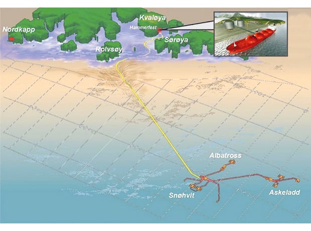
Figure 4.10 Snøhvit. The three discoveries Snøhvit, Askeladd and Albatross have been developed together as the Snøhvit field, with remotely operated subsea installations at depths of 250–345 m. Gas and condensate are transported by pipelines to the LNG (liquefied natural gas) processing plant on Melkøya. Liquid gas is then transported onwards by LNG carrier. (The processing plant and the carrier are shown in the insert.)
Source Statoil
From discovery to production is a long process. At present only one field is on stream in the Barents Sea, and another is under development. The Snøhvit gas field is located in the Hammerfest Basin off Finnmark (Troms I) and consists of the Askeladd West, Askeladd Central, Askeladd, Albatross, Snøhvit North, Beta and Albatross South discoveries (Figure 4.10). Production started in August 2007 and the field will continue to produce gas for at least the next 30 years. Since there are no surface installations, the gas is piped over a distance of 160 km to be liquefied at the LNG processing plant on Melkøya. CO2 is separated from the wellstream and then pumped back into the formation below the reservoir in the Snøhvit field. Recoverable resources when production started were 160.6 billion Sm3 gas, 6.4 million tonnes natural gas liquid (NGL) and 18.1 million Sm3 condensate.
Textbox 4.3 General zero-discharge targets for the oil and gas industry
Zero-discharge targets were adopted in the white paper on an environmental policy for sustainable development (Report No. 58 (1996–1997) to the Storting). The targets and the measures for reaching them have been further specified in a number of later white papers, most recently in the white paper on the Government’s environmental policy and the state of the environment in Norway (Report No. 26 (2006–2007) to the Storting).
Environmentally hazardous substances
Zero discharges or minimal discharges of naturally-occurring environmentally hazardous substances that are also priority substances.
Zero discharges of chemical additives that are black-category (use and discharges prohibited as a general rule) or red-category substances (high priority given to their replacement with less hazardous substances), cf. the Activities Regulations for the petroleum industry.
Other substances
Zero discharges or minimal discharges of the following if they may cause environmental damage:
oil (components that are not environmentally hazardous),
yellow-category substances (not defined as belonging to the black or red categories, but not on the PLONOR list drawn up by OSPAR, meaning that they are considered to pose little or no risk to the environment), and green-category substances (included on the PLONOR list), cf. the Activities Regulations for the petroleum industry,
drill cuttings,
other substances that may cause environmental damage.
Radioactive substances
Discharges of naturally occurring radioactive substances to be gradually reduced until, by 2020, the concentrations in the environment are close to the natural background levels.
The following is a more detailed list of the targets and measures:
As a rule, oil and substances that may be environmentally hazardous may not be discharged to the sea. This applies both to substances added as part of the production process and to naturally-occurring substances. The precautionary principle is to be used as the basis for assessing the potentially damaging impacts of the discharges.
Environmentally hazardous chemicals (red- or black-category) may only be discharged if serious technical or safety considerations make this necessary.
Replacement of environmentally hazardous substances must be given high priority. Operators must draw up plans for replacing environmentally hazardous chemical additives and report them annually to the authorities, cf. the Activities Regulations for the petroleum industry.
The steps taken to replace environmentally hazardous additives must be based on an overall assessment. This means that for example if the use of a small amount of a red-category substance would reduce releases of other components and thereby reduce the overall environmental risk, this should be taken into consideration.
Releases of red-category substances must have been eliminated by 2005 in cases where there are adequate substitutes.
Injection or reinjection of produced water is the most effective method of achieving the zero-discharge targets for naturally-occurring environmentally hazardous substances.
The chosen solution must be based on an overall, field-specific assessment that includes the environmental impacts, overall safety issues, reservoir engineering factors and cost issues.
If there are weighty reasons for doing so, provision may be made on the basis of an overall, field-specific assessment for minimal releases of naturally-occurring environmentally hazardous substances on the priority list.
Economic cost-benefit analyses will be conducted for new and old fields that include overall environmental assessments of measures to prevent discharges of produced water and/or drill cuttings and drilling mud.
The Goliat field, 85 km north-west of Hammerfest, is the first oil field to be developed in the Barents Sea. A plan for development and operation of the field was approved by the Storting in 2009, and production is expected to start in 2013. The field, which will have a floating production, storage and offloading unit, is being developed by the operator Eni. Oil will be loaded onto oil tankers for transport to the markets. Total investment in the development project is expected to be almost NOK 30 billion. Proven recoverable resources amount to about 28 million Sm3 oil and about 8 billion Sm3 gas.
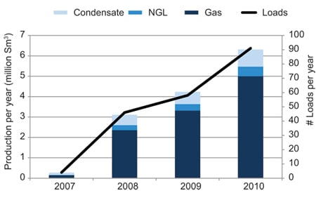
Figure 4.11 Production of hydrocarbons (in Sm3 oil equivalents) and number of transports from Snøhvit since the field came on stream.
Source Ministry of Petroleum and Energy
Award of licences
Since the publication of the first management plan for the Barents Sea–Lofoten area in 2006, acreage has been allocated through ordinary licensing rounds, which are normally held every other year, and through annual awards in predefined areas (APAs). The APA system, which was established in 2003, is the annual licensing round for allocation of blocks in more mature areas. The mature areas are the most thoroughly explored areas on the continental shelf, where the geology is known and where there are fewer technical challenges and a well developed or planned infrastructure. The overall framework for oil and gas activities (areas, restrictions on when drilling is permitted, other considerations) is established in management plans for each individual sea area, which are based on the existing knowledge about ecosystems and fisheries. These management plans apply to all new licences awarded in an area, regardless of whether they are announced through the APA system or in a numbered licensing round. The APA system has been evaluated, and the Government will discuss the evaluation in more detail in the forthcoming white paper on petroleum activities.
In APA 2007, seven new production licences were awarded, and in APA 2008, APA 2009 and APA 2010, two, three and two new production licences respectively were awarded in the Barents Sea. Six new production licences were awarded in the 19th licensing round, in 2006, and nine new licences were awarded in this area in the 20th round, in 2009. In the 21st licensing round, in autumn 2010, 51 blocks in the management plan area were announced. Further production licences were awarded in spring 2011.
Assignment of licences in APAs has resulted in greater and more stable activity in the management plan area. Since 2006 the total APA area has been almost doubled (Figure 4.12). The APA system will be evaluated in the white paper on oil and gas policy to be presented in spring 2011.
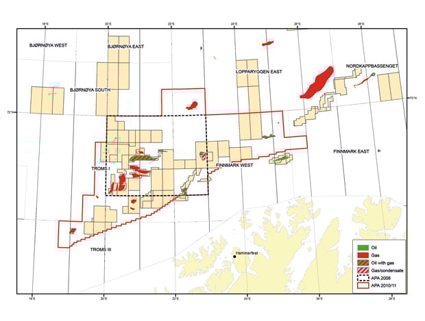
Figure 4.12 The awards in predefined areas (APA) system in the Barents Sea. The black dotted line shows the border of the APA in 2006. The red line shows the extent of the area in 2010/11.
Source Norwegian Petroleum Directorate
4.3.3 Surveys of oil and gas resources
The Barents Sea is the least explored petroleum province on the Norwegian continental shelf. However, together with the deep-water areas in the Norwegian Sea and the areas off the Lofoten and Vesterålen Islands, it is believed to be the province where the probability of future large discoveries is highest. In the Norwegian part of the Barents Sea outside the area covered by the maritime delimitation treaty between Norway and Russia, the statistical expected value of undiscovered resources is 945 million Sm3 o.e., which corresponds to 37 % of the total undiscovered resources on the Norwegian continental shelf.
When the Storting debated the integrated management plan for the Barents Sea–Lofoten area, the Norwegian Petroleum Directorate was given the task of surveying the geology of Nordland VII and Troms II in connection with the possibility that there were petroleum resources in these areas. During the period 2007–09, the Directorate collected geological, seismic, electromagnetic and gravimetric data in the waters off the Lofoten and Vesterålen Islands and Troms (Nordland VII and Troms II) (see Figure 4.12).
Following up the management plan for the Norwegian Sea, which concludes that the possibility of initiating an opening process for the northern part of the coastal zone in Nordland will be considered, the Petroleum Directorate also estimated, on the basis of existing data, the resource potential in the Vestfjorden, the unopened part of Nordland V, Nordland VI and the Eggakanten area along the edge of the continental shelf. With the exception of Nordland VI, knowledge of these areas is limited and no prospects have been identified, but the Directorate considers that the presence of hydrocarbons in these areas cannot be excluded.
The waters off Nordland and Troms have varied and interesting geological features. The geological continental shelf is at its narrowest here, in some places narrower than 20 km. After sloping down to a depth of about 400 m, it drops sharply to the deep sea plains more than 2 500 m below the sea surface. In the context of petroleum deposits, these areas are expected to show continuations of geological trends from the north and further south. Some of the most important types of reservoir rock in Nordland VI are likely to be similar to those in the discovered reservoirs of the same age further south in the Norwegian Sea. The northern parts of Nordland VII and Troms II, on the other hand, are expected to show more similarities with the geology of the Barents Sea. The main type of source rock for oil and gas in the area is organically rich claystone from the late Jurassic period. The types of reservoir rock with the greatest petroleum potential in the surveyed areas are sandstones laid down in the Triassic, Jurassic, Cretaceous and Palaeogene periods, with the greatest potential in the Triassic and Jurassic layers. Most of the petroleum prospects lie close to the coast.
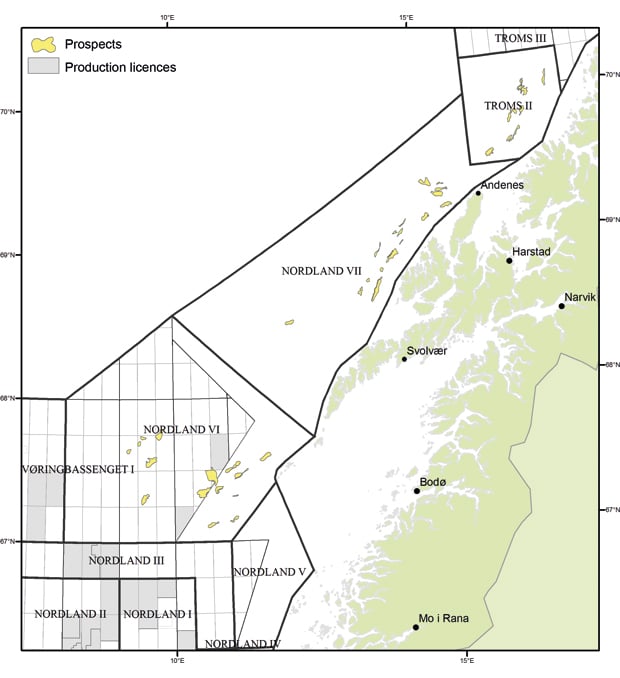
Figure 4.13 Mapped prospects in Nordland VI, Nordland VII and Troms II, 2007–09
Source Norwegian Petroleum Directorate
The main conclusions from the seismic surveys are that, on the basis of existing knowledge:
202 million Sm3 o.e. is expected to be discovered (with an uncertainty range of 76–371 million Sm3 o.e.) in the surveyed area.
Nordland VI appears to be the area with the greatest petroleum prospectivity.
The total expected resources in Nordland VII and Troms II are at the same level as the expected resources in Nordland VI.
The probability of finding oil is greatest in Nordland VI and VII, and that of finding gas is greatest in Troms II.
In its report, the Petroleum Directorate concluded that the seismic data for Nordland VII and Troms II are now adequate, but that knowledge of the geology of the areas off the Lofoten and Vesterålen Islands and Senja is still limited, and the estimates of undiscovered resources are very uncertain. However, the level of uncertainty can be reduced by further processing of the data and exploration drilling.
4.3.4 The importance of petroleum activities for value creation and Norwegian society
The petroleum resources on the Norwegian continental shelf have laid the foundation for the development of a substantial oil and gas industry in Norway. The petroleum sector includes oil companies, supplier industries and petroleum-related research and education institutions. It accounts for a substantial proportion of Norwegian value creation and provides employment in all parts of the country.
In 2009, the petroleum sector accounted for 22 % of Norway’s GDP, and in the same year the value of petroleum exports was almost NOK 480 billion. The sector also accounts for over one-quarter of state revenues and total investment. During the 40 years of oil and gas production on the Norwegian continental shelf, the value created by the industry has amounted to around NOK 8 000 billion at the current monetary value.
The demands created by the petroleum industry generate a large number of jobs. Statistics Norway has estimated that in 2009 the industry was responsible, directly or indirectly, for around 206 000 jobs.
Since petroleum activities have only recently been started in the north and have so far been limited, employment resulting from the industry in the region has been far below the national average. The industry employs just over 2 000 people in North Norway, which is less than 1 % of all employment in the region. However, the growth in petroleum activity is resulting in rising employment, and the increase is higher than the national average in all the counties in North Norway. This applies especially to Finnmark, due to the development and operation of the Snøhvit field.
Development of the Snøhvit field in 2002 was the first gas development in the Barents Sea, and the plant at Melkøya near Hammerfest was the first LNG processing plant to be established in Norway. Up to 2 500 people were employed in the construction phase up to the start of production in 2007. Operation, maintenance, modification and support services for the field have created over 300 permanent jobs in North Norway and led to large investments in the regional business sector. Almost NOK 3 billion of total deliveries to the Snøhvit field are supplied by businesses registered in North Norway.
Case studies show that Snøhvit has reversed the negative population and employment trends in Hammerfest. New companies are being established, and there is now a shortage of manpower in the region. Housing construction is expanding considerably, and a substantial increase in municipal revenues is expected. Substantial investments have been made in upgrading school buildings and infrastructure and in developing cultural facilities. The higher level of competence in the region resulting from the Snøhvit development has also benefitted other industries.
The Goliat development will be able to build further on this industrial expansion and increased expertise. The regional office responsible for operations will be situated in Hammerfest and the helicopter and supply base in the surrounding area. Together they will create 150–200 jobs in the operational phase, and the spin-off effects will generate additional jobs in supply industries and in the region as a whole. The operational phase for Goliat is estimated at a minimum of 15 years, and the operator will be cooperating with the supplier network.
As a result of cooperation with the fisheries industry, fishing vessels can now be used in oil spill response, both along the coast and on the continental shelf, in order to strengthen preparedness and response and make it more flexible. From now on types of vessels such as tugboats, aquaculture vessels and search and rescue vessels can also be used in oil spill response.
For almost 25 years Helgelandsbase in Sandnessjøen has supplied exploration rigs and oil fields, such as Norne on the Nordland area of the Norwegian continental shelf, with goods and equipment for activities off the Helgeland coast. Around 50 persons are employed at Helgelandsbase, which in 2007 purchased goods and services worth about NOK 280 million from businesses in Nordland. In the same year almost 390 ships called at the base. The Skarv and Idun oil and gas fields are equipped with production ships, and Helgelandsbase in Sandnessjøen serves as their supply base. From 2006 to 2008 Sandnessjøen doubled its petroleum-related turnover, showing how proximity to the Norne, Skarv and Idun fields has promoted growth in the region.
In Nordland more than 20 % of the industrial turnover, amounting to over NOK 1.5 billion, was petroleum-related in 2008. This was an increase of 50 % from 2006.
Future scenario
Petroleum activities provide jobs at both the local and the regional level. The number of jobs depends primarily on whether discoveries are made, the size of the discovery and the type of development.
In cooperation with the Nordland Research Institute, Asplan Viak has carried out a study examining the possible spin-off effects of the potential expansion of petroleum activities in the Barents Sea and the northeastern part of the Norwegian Sea. The conclusions of the report that apply to oil and gas activities in the waters off the Lofoten and Vesterålen Islands and Senja are discussed in more detail in section 4.9 below.
The analysis was based on a resource scenario developed by the Norwegian Petroleum Directorate that includes the sea area from the coastal zone in the Norwegian Sea up to and including opened areas in the southern part of the Barents Sea. The study provides a basis for estimating spin-off effects with different resource outcomes. It includes 18 different fields with an overall resource estimate of nearly 600 million Sm3 o.e. The expected recoverable resources in the northeastern part of the Norwegian Sea and the Barents Sea are considerably larger than those on which the 2009 prognosis was based.
The Asplan Viak study estimated that development of the 18 fields could provide increased employment in North Norway of between 4 000 and 6 000 full-time jobs from 2016 to 2043. Until 2016 employment will rise gradually, while after 2043 it will gradually decline. According to these estimates, activity will be greatest in the northern part of the region, mainly because larger resources are expected to be found in the sea areas bordering on this region. According to the report, further development of the Snøhvit field would result in an employment peak of almost 2 800 jobs in the development phase, and in the operational phase well over 1 000 new jobs. A large proportion of these employees are expected to come from northern Troms and Finnmark.
4.3.5 Evaluation of the pressures and impacts associated with petroleum activities
Produced water
Produced water contains residues of chemicals introduced during drilling and production, and environmentally hazardous substances that occur naturally in the reservoir (for example alkyl phenols, polycyclic aromatic hydrocarbons (PAHs), heavy metals and radioactive substances). The volume of produced water increases with the age of the well. Produced water occurs primarily in oil extraction and only to a lesser extent in gas production.
The acute impacts of operational discharges of produced water and drill cuttings are assessed as insignificant since they will generally be local and short-term and will not have effects at population level. Nor have any long-term effects at this level been demonstrated by monitoring. However, further studies are being done on the long-term impacts of exposure to low concentrations of environmentally hazardous substances in produced water.
Norwegian waters are in general subject to strict discharge requirements, and zero-discharge targets were adopted in the white paper on an environmental policy for sustainable development (Report No. 58 (1996–1997) to the Storting). This means that as a general rule, no oil or environmentally hazardous substances, whether naturally occurring chemicals or chemicals added during the production process, may be discharged to the sea (see Box 4.3). In addition stricter requirements have been imposed in the management plan area, where discharges of produced water and/or drill cuttings are not permitted (see Box 4.2).
The Norwegian Sea and the North Sea
Although produced water is treated before discharge, not all the environmentally hazardous substances from the reservoir can be removed with existing treatment technology. According to the Climate and Pollution Agency’s 2010 evaluation of the status of the work on zero discharges, injection of produced water is the only method that can eliminate discharges of naturally occurring chemicals. Treatment can substantially reduce the content of oil and oil-related components such as PAHs and alkyl phenols, but has no effect on the content of heavy metals or radioactive substances.
The general zero-discharge targets for environmentally hazardous chemical additives for the continental shelf are considered to have been reached since 2005, but not the targets for certain naturally occurring chemicals. In 2008 new requirements for discharges to sea in the North Sea and the Norwegian Sea were considered, but a report from the Pollution Control Authority (now the Climate and Pollution Agency), the Petroleum Directorate and the Radiation Protection Authority concluded that general requirements for zero discharges of produced water and/or drill cuttings and drilling mud should not be introduced for the Norwegian continental shelf.
The Barents Sea
Petroleum activities in the Barents Sea–Lofoten area are subject to the general requirement of zero discharges to the sea during normal operations (see Box 4.2). However, this only applies to new developments. The requirement applied to the Snøhvit field is that the planned operations should not harm the environment, which means that no harmful substances may be discharged during operations. Discharges of small amounts of produced water are permitted, which can be treated at the onshore biological treatment plant for discharges to sea. All discharges to sea require a permit from the Climate and Pollution Agency. Water from treatment plants is released at a depth of 40 metres in an area with a strong current on the north side of Melkøya. The impacts of these discharges are considered to be small and very local. The development of the Goliat field has been designed to allow injection of produced water that can also be used as pressure support for enhanced oil recovery.
The impacts of oil spills are discussed in more detail in Chapter 5.2 on environmental risk.
Discharges of drill cuttings and drilling mud
Drill cuttings are sand and gravel that are removed from the bore hole as the well is being drilled, and contain chemicals from drilling fluids. Discharges of drill cuttings can affect benthic fauna such as corals and sponge communities by smothering them with sediment in small areas close to the bore hole. In the Barents Sea–Lofoten area the requirements for treatment of drill cuttings are stricter than those for the rest of the continental shelf, and it is a general requirement that drill cuttings must be reinjected or treated on land. Drill cuttings and drilling mud from the tophole section may be discharged, but only in areas where damage to vulnerable components of the environment is considered unlikely. Such assessments must be based on thorough surveys of such components.
In connection with exploration drilling in the Barents Sea, the discharge permits issued to the operators under the Pollution Control Act have included specific requirements on reporting to the Climate and Pollution Agency for each exploration well. Operators are required to conduct environmental monitoring after the wells have been drilled and monitor the treatment of landed drill cuttings.
The operators (Statoil and Eni) have reported their experience of treating drill cuttings to the Climate and Pollution Agency. A total of 7 673 tonnes drill cuttings have been discharged as a result of drilling in the Barents Sea, 5 525 tonnes of which have been taken ashore for disposal and/or re-use (Table 4.1).
Table 4.1 Quantities of drill cuttings discharged, or taken ashore for disposal and/or re-use, in the Barents Sea, 2005–09
Operator | Discharges from the tophole section (tonnes) | Slurrified/ re-used (tonnes) | Onshore disposal (tonnes) |
|---|---|---|---|
Eni (3 wells) | 1 824 | 1 134 | |
Statoil (13 wells) | 5 849 | 652 | 3 739 |
Total | 7 673 | 652 | 4 873 |
Source Climate and Pollution Agency
A number of different chemicals are used in the drilling process, including drilling fluids, cement chemicals, utility chemicals and pipe dope. Chemicals used in drilling account for about 90 % of the total consumption and discharge of chemicals. Seawater and potassium chloride (which also occurs naturally in seawater) are generally used in drilling the tophole section and pilot hole. The discharges consist mainly of water and green-category chemicals. Discharges of yellow-category chemicals amount to 0.04 % of total discharges, and the use and discharge of red-category chemicals are minimal (Table 4.2). No black-category chemicals are used or discharged (their use and discharge are as a rule prohibited).
Table 4.2 Use and release of chemicals in drilling for wells in the Barents Sea, 2006–09. Green category: presumed not to have a significant impact on the environment. Yellow category: not environmentally hazardous and not classified as green. Red category: environmentally hazardous, high priority given to their replacement.
Category | Use | Released |
|---|---|---|
Green | 15 222 tonnes | 5 444 tonnes |
Yellow | 176 tonnes | 2.4 tonnes |
Red | 18 kg | 1 kg |
Source Climate and Pollution Agency
No significantly elevated levels of hydrocarbons have been found in the sediment samples taken around any of the investigated exploration wells. Barium, which may indicate the discharge of drill cuttings, has been found around some of the wells.
The operators’ investigations of the seabed after drilling showed that drill cuttings were deposited on the sediments within a radius of 50 m around the well. Outside this area sediment was partly covered out to a radius of 100 m. Statoil’s investigations after drilling in the Snøhvit field indicate that the area where the cuttings have impacts on the fauna shrinks over time and that the fauna in the area returns to normal levels. These findings have been supported by studies conducted by Statoil at the Morvin field in the Norwegian Sea, which showed that after three years the fauna were returning to normal levels.
Transporting drill cuttings to land, treating them for disposal and re-using them increases pressure on the environment. Transport uses large amounts of energy, resulting in large emissions to air (about 305 kg CO2 per tonne cuttings). The Climate and Pollution Agency has estimated that CO2 emissions from the transport of drill cuttings to land account for about 3 % of total CO2 emissions generated by exploration drilling.
Cuttings from drilling with water-based mud must be treated before disposal on land in order to reduce the content of salt and dissolved organic carbon. The benefits of re-using drill cuttings in drilling other wells have been found to be smaller than expected because of the high transport costs and the need to add more chemicals. At present we do not know enough about the possibilities of re-using drill cuttings, but this alternative should be further explored, since re-use is normally a better solution than disposal. However, tests have shown that cuttings from drilling with water-based mud can be re-used as a raw material in the manufacture of concrete.
Ordinary hose systems for transferring cuttings from the rig to the ship cannot be used for drill cuttings containing water-based drilling mud. Thus at present cuttings are transferred from the rig to the ship in containers by means of cranes, which involves a risk to the personnel. However, better technology is being developed.
Acquisition of seismic data
In 2009 the Petroleum Directorate, the Directorate of Fisheries and the Pollution Control Authority (now the Climate and Pollution Agency) drew up a report on acoustic disturbance and other negative impacts on fish and marine mammals caused by seismic activity, with recommendations for testing. With regard to the scare effect on fish, it was not possible to ascertain how far away from the source of the noise the effect made itself felt, with the result that no recommended minimum distance from fishing activities, etc. could be established. This was mainly due to the fact that relatively little research had been done on scare effects, and that the commercial interests could not agree. It should be noted that the way sound waves travel and the distance travelled under water depends on hydrographic conditions, which vary through the year and often from area to area. The Institute of Marine Research conducted a seismic survey in the waters off the Lofoten and Vesterålen Islands in the period 29 June–9 August 2009 in order to obtain better documentation on the effects of noise from seismic surveys on several commercial fish species and thus on catch opportunities for fishermen.
The main conclusions of the study were that seismic surveys had not been found to harm marine life, but that the noise affected the behaviour of the fish and there were changes (increases or decreases) in the size of catches while the surveys were being conducted. Gillnet catches of Greenland halibut and redfish increased during and after the surveys, while longline catches of Greenland halibut and haddock declined but increased again after the surveys had been completed. Swimming activity increased, which can be a sign of stress. However, no significant changes in feeding by the fish were found. During the surveys the density of saithe in the area declined, but there were no changes in the distribution of the other species. With regard to direct damage to fish larvae, previous research has shown that only larvae within a maximum radius of 5 m from the sound source suffer any damage. On the basis of these studies it has been concluded that seismic surveys do not cause damage at the population level.
4.4 Tourism
4.4.1 Management
In the Government’s High North Strategy of 2006 and the updated strategy of 2009, it was pointed out that the tourist industry in the region has a particularly strong competitive advantage. Encouraging tourist industries promotes development in coastal communities and creates new jobs that can halt or limit the depopulation that is depleting many coastal municipalities.
The High North and the Sami areas are given special mention in the Government’s tourism strategy of 2007. The strategy states that there is a need for greater coordination across the borders of the three northernmost counties and that the region would benefit from a joint, focused marketing strategy for the foreign market. In 2009 the three northernmost counties established a joint marketing organisation, Nordnorsk Reiseliv AS, to promote the image of the region abroad. The organisation became operative in January 2010.
4.4.2 The importance of tourism for value creation and Norwegian society
The tourist industry depends on and helps to maintain viable coastal communities along the Norwegian coast. Few countries have as long and varied a coastline as Norway, and the coastal environment, the fjords and the open sea have great potential in terms of tourism. The industry comprises a wide range of activities and sectors, a large proportion of which involve sales to travellers. They include transport, accommodation and restaurant services, travel and tour companies, and companies offering attractions and activities of various kinds. Growth in the number of tourists has spin-off effects, especially in the retail sector, in addition to direct value creation by travel and tour companies.
Statistics Norway has published a report on tourism and its economic importance, which showed that the industry accounts for a larger proportion of total production in the three northernmost counties than in the rest of the country, apart from Akershus, where it accounted for 9.7 %. In 2006 tourism accounted for 6.7 % of total production in Nordland and 6 % of total production in Troms and Finnmark. The average figure for mainland Norway as a whole was 5.5 %. Total consumption by Norwegian and foreign visitors and tourists in North Norway in 2009 was estimated at NOK 19 billion, divided as follows between the three counties: Nordland NOK 8.6 billion, Troms NOK 6.6 billion and Finnmark NOK 3.8 billion.
The tourism sector in North Norway employs about 17 970 persons in the three northernmost counties. Half of these work in Nordland, one-third in Troms and one-sixth in Finnmark. The industry is relatively speaking a more important creator of jobs in Nordland, where 8.6 % of the total number of employed persons work in the industry, than in Troms or Finnmark, where the corresponding figures are 5.7 % and 6.9 %.
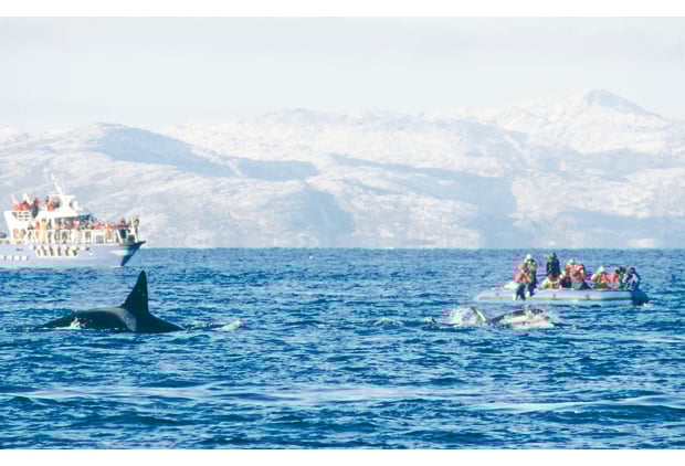
Figure 4.14 Whale safari
Source Norwegian Polar Institute
The number of commercial guest nights in the three northernmost counties in the period 2005–09 rose by 5.9 % (Figure 4.15). North Norway’s share of the total Norwegian market for guest nights decreased from 2003 to 2007, but since then the share has shown a considerable increase.
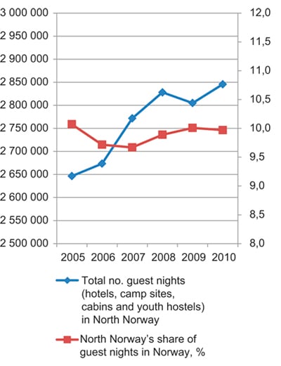
Figure 4.15 Number and market share of guest nights for North Norway in the period 2005–10
Source Statistics Norway
Some of the regions bordering on the management plan area have experienced particularly strong growth in the last few years. This applies particularly to the Lofoten Islands, where the number of guest nights has risen by 34.6 %. If parts of the natural and cultural landscape in the islands are inscribed on UNESCO’s World Heritage List, this will also have a positive effect on the already rapidly growing tourist industry in the area. Inscription on the World Heritage List normally has a significant impact on tourism, and increasing attention is being paid within UNESCO to the possibilities and challenges of world heritage tourism. In some areas the number of visitors has increased by several hundred per cent, although in others the increase has been considerably smaller. The number of visitors to the Vega Archipelago increased sixfold from 2004, when it was inscribed on the List, to 2009.
The spectacular scenery, the exoticism of the Arctic and the viable coastal communities form the main foundation for the tourist industry in the High North, and occupy a key place in promoting Norway’s image abroad. The coast and coastal culture, and Arctic Norway are two of the four key elements in Innovation Norway’s branding strategy for Norway as a tourist destination.
The Lofoten Islands, the North Cape and Hurtigruten are among the best known tourist products in Norway. The cruise sector is growing rapidly along the entire coast, and in North Norway the Lofoten Islands, Tromsø and the North Cape area experienced particularly strong growth in the period 2006–10.
Six of the 18 national tourist roads that are being developed or planned are in the vicinity of the management plan area (Helgelandskysten Nord, Lofoten, Andøya, Senja, Havøysund and Varanger). Norway’s national tourist roads have attracted international attention, and are expected to continue to play a central role in the promotion of North Norway. They will also encourage the development of tourist products in the areas through which they pass.
Tourism in Svalbard has grown substantially in the last 10 years, and the number of guest nights rose from 61 277 in 2000 to 81 718 in 2010, with a peak of 92 000 in 2008. From 2003 to 2009 the number of person-years in direct employment in the tourist industry rose from 165 in 2003 to 179 in 2009, having reached a peak of 227 in 2008. In addition to the 179 persons directly employed, tourism accounted for 73 person-years in tourism-derived industries in 2009. In the same period (2003–09) the turnover in the tourist industry increased from NOK 215 million to NOK 371 million, in addition to the turnover in local businesses, which amounted to around NOK 104 million. The most recent white paper on Svalbard (Report No. 22 (2008–2009) to the Storting) stated that tourism is one of the three main industries in the archipelago, and that the Government is in favour of further development of the industry as a basis for additional value creation in the area and to promote settlement in Longyearbyen. Experiencing the attractions of Svalbard mainly requires traffic in and close to the islands’ vulnerable, untouched nature, and this makes it imperative that further development of tourism in the area should take place within a safe and environmentally sound framework.
Whether to nominate parts of the Svalbard archipelago for inscription on the World Heritage List is being considered, and is discussed in more detail in the white paper on Svalbard.
Sea-fishing tourism
This form of tourism has grown considerably in the last 10–15 years in Norway. In several coastal communities it has contributed substantially to value creation and employment, especially during the summer season, when tourism is an important source of income.
Total value creation in Norway by the 434 fishing tourism enterprises is estimated at NOK 222 million a year, of which NOK 100 million is created in North Norway.
In order to help ensure the sustainability of sea fishing, the Ministry of Fisheries and Coastal Affairs has appointed a working group to examine the need to regulate commercial activities based on sea fishing tourism and suggest management measures. The members include representatives of the industry itself, relevant research communities and management authorities.
The group will present a final report on its work with proposals for new measures.
4.5 Environmental management
The environmental authorities have several important tools at their disposal in connection with activities in the Barents Sea–Lofoten area. For Norway’s territorial waters these are mainly based on the Nature Diversity Act, while for Norway’s exclusive economic zone and the Norwegian continental shelf, the most important tools are based on the Pollution Control Act, political action plans and strategies.
4.5.1 Management and measures
Marine protected areas
It is a national target to establish a representative network of marine protected areas (MPAs) in the different biogeographical regions in Norway’s coastal and marine areas by 2012. Protection of selected marine areas is a key element of ecosystem-based management, and is intended to play a part in halting the loss of biodiversity, safeguarding the natural resource base and maintaining a representative selection of marine environments as reference areas for research and monitoring. Establishing MPAs will meet some of Norway’s international commitments, including the target under the Convention on Biological Diversity that at least 10 % of coastal and marine areas are to be protected by 2020.
The fisheries authorities have already introduced various forms of protection for several areas as part of the management regime for living marine resources. In the white paper Integrated Management of the Marine Environment of the Norwegian Sea (Report No. 37 (2008–2009) to the Storting), the Government decided to draw up a marine protection plan. The first phase will cover 36 MPAs, and the planning process for the first 17 began in September 2009. Four of these (Lopphavet, Ytre Karlsøy, Rystraumen and Rossfjordstraumen) are in the coastal zone or just inside the Barents Sea–Lofoten area. The planning process for the remaining 19 MPAs will begin in 2011. Four of these (Tanafjorden transect, Indre Porsangerfjord, Andfjorden transect and Røstrevet) are also situated in the coastal zone or just inside the Barents Sea–Lofoten area.
In addition 87 % of the territorial waters around Svalbard, including Bjørnøya, lie inside nature reserves and national parks that are protected under the Svalbard Environmental Protection Act.
Protection of seabirds
An important part of seabird management is protecting their habitats. All Norwegian counties with a coastline have their own conservation plans for preserving important seabird colonies.
Hunting seasons for seabirds
The Directorate for Nature Management regulates which bird species may be hunted, the hunting season for each species and the areas where they may be hunted. The regulations apply for five years at a time. The current regulations apply until 31 March 2012, and will be revised by then.
Priority species
Under section 23 of the Nature Diversity Act, particular species may by regulations be designated as priority species. The provisions on priority species apply in Norway’s territorial waters out to the territorial limit (12 nautical miles). Measures to protect a species may include a prohibition on removal of, damage to or destruction of the species, as set out in section 24, first paragraph, of the Act. The provision concerning protection of areas with specific ecological functions for the species (in section 24, first paragraph, b)) does not apply in the sea. The first proposal for designation of priority species was circulated in 2010 by the Directorate for Nature Management, and did not include any marine species or seabirds. However, further rounds of proposals will be held, which could include species that are found in the management plan area. The management of any marine species designated as a priority species will call for close cooperation and coordination between the environmental and fisheries authorities.
Selected habitat types
Under section 52 of the Nature Diversity Act, specific habitat types may by regulations be designated as selected habitat types in parts of or throughout the country, and the provisions apply in Norway’s territorial waters out to the territorial limit (12 nautical miles). The objective is to maintain the diversity of habitat types within their natural range. When a habitat type has been designated as selected, special account must be taken in the exercise of public authority of areas of the habitat type, so as to avoid reduction of the range of the habitat type or deterioration of the ecological status of the areas. In 2010 the Directorate for Nature Management circulated a proposal for designation of five selected terrestrial habitat types. Although no marine habitat types have so far been proposed as selected habitat types, further rounds proposing new selected habitat types will be held, which could include habitat types that are found in the management plan area.
Alien species
Maritime traffic between biogeographical regions entails a risk of the spread of alien species through discharges of ballast water and hull fouling. In 2004, the IMO adopted the International Convention for the Control and Management of Ships’ Ballast Water and Sediments (Ballast Water Convention), which is intended to reduce the risk of the spread of harmful aquatic organisms or pathogens. Although the convention has not yet entered into force, Norway has implemented some of its requirements in the Regulations on the prevention of the spread of alien species through ballast water and sediments from ships (the Ballast Water Regulations), which entered into force on 1 July 2010. The provisions regulating the depths at which ballast water may be exchanged apply to all ships sailing in and out of Norwegian territorial waters and Norway’s exclusive economic zone that have taken up ballast water outside certain specified areas. Requirements for treatment of ballast water will be introduced when the Ballast Water Convention enters into force.
The first management plan for the Barents Sea–Lofoten area was followed up by a white paper on the red king crab (Report No. 40 (2006–2007) to the Storting). In addition analyses were made of the ecological risk posed by a number of alien species. Those posing a high risk were entered on the 2007 Norwegian Black List and a national Strategy on Invasive Alien Species was drawn up in 2007. Alien species in the Barents Sea, such as the snow crab and the red king crab, are both considered to represent a high risk to Norwegian ecosystems. The strategy emphasises that if the Northeast Passage is opened to traffic, this will further increase the risk of alien species from distant regions being introduced.
World Heritage status for the Lofoten Islands
In 2002 the Lofoten Islands were placed on Norway’s tentative list of areas to be nominated for inscription on the World Heritage List. The nomination process was formally started by the Bondevik II Government in 2005, and was supported by all six of the Lofoten municipalities. However, at the request of Lofotrådet (a cooperation body for the six municipalities in the Lofoten Islands) the Ministry of the Environment suspended work on the nominations in September 2009 pending the update of the management plan for the Barents Sea–Lofoten area. At the request of the Ministry, the Directorate for Nature Management put together the nomination documentation as far as possible within the imposed framework and limitations. The documentation sets out the natural and cultural qualities of the islands that would qualify them for inscription on the List. If it is decided to continue work on the nomination, a further process will be started to complete the material for submission to UNESCO. This will also involve seeking the necessary local political approval, since UNESCO insists that the local as well as the national authorities commit themselves to doing their utmost to protect and safeguard the cultural heritage values of the area over the long term.
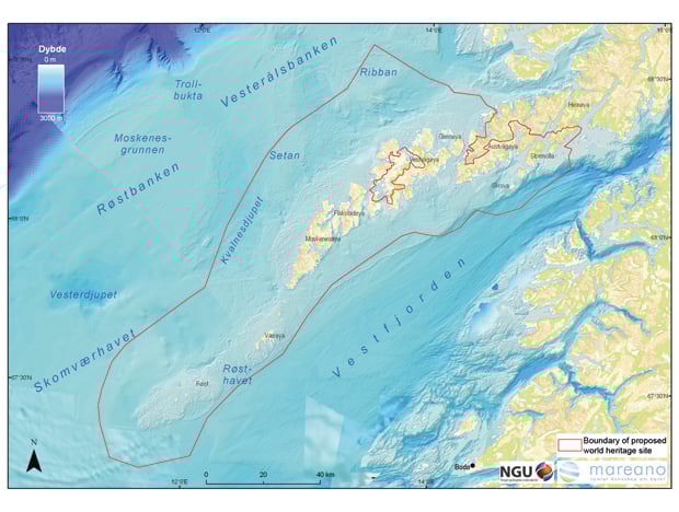
Figure 4.16 Map of the area proposed for inscription on the World Heritage List
Source Ministry of the Environment
4.6 Offshore energy
At present there are no offshore energy plants in the management plan area, but theoretically there is a very large potential for renewable energy production in Norwegian waters. Offshore energy includes offshore wind power, wave power, marine current power, tidal power and osmotic power.
4.6.1 Management
Under the Offshore Energy Act (see Chapter 2.3), offshore renewable energy production may in principle only be established after the public authorities have opened specific geographical areas for licence applications. The intention is that the authorities should introduce spatial planning processes to ensure that energy production takes place in areas where the potential for conflict is as low as possible. The Act stipulates that strategic impact assessments should be conducted under the auspices of the authorities before the decision to open geographical areas is made.
The first step in the process of deciding which areas are suitable for offshore renewable energy production was completed in autumn 2010. A working group consisting of the Norwegian Water Resources and Energy Directorate, the Directorate for Nature Management, the Directorate of Fisheries, the Norwegian Coastal Administration and the Petroleum Directorate has drawn up a report on proposed areas for impact assessments in connection with offshore wind power. Various sea areas were assessed for their suitability for offshore wind power development, and the evaluation included a discussion on the necessary technical and economic conditions, such as wind resources, water depth, electricity transmission and supply and market factors. Environmental interests and potential conflicts of interest over the use of sea areas were also discussed (see section 4.6.4 below). The report and the comments received during the consultation process will be used as the basis for selecting areas where the first series of strategic impact assessments will be conducted. The impact assessments will be started in 2011, and the status and plans for further work will be submitted to the Storting in connection with the revision of the offshore energy strategy in 2012.
Altogether the working group proposed 15 areas for impact assessments with a view to offshore wind power development, five of which lie off the Lofoten Islands, Troms and Finnmark (see Figure 4.17).
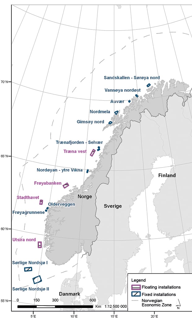
Figure 4.17 Proposed areas for impact assessments with a view to offshore wind power development
Source Norwegian Water Resources and Energy Directorate
The only area to be assessed that is actually inside the management plan area is Sandskallen, which is just outside the baselines, while the Nordmæla area lies on the baseline. The other three areas lie just inside the baselines. The proposed areas are in water shallow enough for fixed installations to be built and connected to the electricity grid on land. Up to 2020 the only areas that are likely to be opened will be among those proposed by the working group.
4.6.2 Activities
No renewable offshore energy plants have so far been established within the management plan area. However, there are two tidal power plants inside the baselines. A prototype tidal power plant in Kvalsundet in Finnmark has been in operation since 2003 and has been supplying power to the electricity grid. It was verified and reinstalled in 2009. In addition Hydra Tidal opened a prototype floating tidal power plant, Morild II, in Gimsøystraumen in Nordland in autumn 2009. Testing and verification of the plant began in November 2010.
At present the authorities are not aware of any plans for offshore energy plants in the management plan area, but the Norwegian Water Resources and Energy Directorate has received notification of three wind power projects inside the baselines off the Lofoten Islands and Troms (Lofoten havkraftverk, Gimsøy and Vannøya). Pending further work on the spatial planning processes for the proposed areas mentioned in section 4.6.1, the Directorate has been requested not to give priority to dealing with new reports of major wind power projects inside the baselines.
4.6.3 Importance for value creation and Norwegian society
The Norwegian business sector and research communities have a high level of expertise on various aspects of offshore technology, marine operations and other important fields that are vital for the development and operation of renewable energy sources and offshore infrastructure. The development and operation of onshore wind power plants will also provide knowledge that can be used in the future development of offshore wind power on a large scale.
The theoretical potential for offshore wind power production in Norwegian sea areas was previously estimated at up to 14 000 TWh/year. However, this was revised in the report on offshore wind power mentioned in section 4.6.1, where a rough screening was carried out and an estimate was given for the areas proposed for impact assessments. Energy system considerations and other environmental factors and user interests in the same sea areas were taken into account when selecting these areas. The potential capacity in MW for each of the areas in the report has been estimated. The figures are based on the geographical extent of the area and on how they would fit into the rest of the power supply system. Altogether it would be possible to build an installed capacity of up to 5–12 GW in these areas, which would produce 18–44 TWh. The five areas off the Lofoten Islands, Troms and Finnmark would have a possible installed capacity of 0.5–1.5 GW, and produce 2–5 TWh. As strategic impact assessments are carried out and if areas are subsequently opened for applications, more knowledge will be built up that can be used to improve estimates of the production potential.
4.6.4 Assessment of the pressures and impacts associated with future offshore energy development
Offshore wind farms will have environmental impacts in the construction and operational phases and when they are closed down and decommissioned. Since not many offshore wind farms have been established, our knowledge of the impacts on marine ecosystems is limited. Among the possible environmental impacts are negative effects of noise on fish and marine mammals, loss of habitats, damage to benthic habitats, collisions between seabirds and wind turbines, and the visual impact on the seascape. Wind farms are also likely to occupy areas where they will have impacts on other activities such as oil and gas production, shipping, fisheries, recreation and tourism, or that have been designated as marine protected areas (see section 4.8.6).
These factors are discussed in the report on offshore wind power and will be further examined in the strategic impact assessments prior to the opening of areas.
4.7 Other industries: bioprospecting and mineral extraction
4.7.1 Marine bioprospecting
The Government views marine bioprospecting as a means to new, sustainable value creation. The potential for value creation is substantial, and Norway is in a good position to make its mark in international competition. The Government considers that Norway’s long coastline and extensive sea areas, with their access to resources and high species diversity, offer rich opportunities. In addition the infrastructure and research groups needed to collect and screen a wide variety of marine organisms are available in Norway. In combination with the national expertise that has already been developed in the marine sector and biotechnology, this gives Norway a good starting point for a national initiative for marine bioprospecting. In autumn 2009 the Government presented a national strategy to facilitate research and business development related to marine bioprospecting. The goal was to activate the entire range of value creation potential by means of a targeted, coordinated national effort. The High North is a key element in the strategy and priority will be given to gathering marine organisms from the northern sea areas.
Norway is responsible for managing large sea areas where few surveys have been made. Some of the marine organisms live under extreme conditions: in Arctic waters, under low temperatures and changing light conditions, or in oil reservoirs, under high pressure and high temperatures. Others live in coastal areas and fjord waters, where there are large concentrations of other species. Many of these marine organisms are likely to have properties that can be exploited and used in the manufacture of new products and processes in a number of industrial sectors.
Bioprospecting is based on consent and specifically regulated in sections 9 and 10 of the Marine Resources Act and Chapter VII of the Nature Diversity Act. Genetic material obtained from the natural environment is a common resource belonging to Norwegian society as a whole and managed by the state. It is to be utilised to the greatest possible benefit of the environment and human beings in both a national and an international context, also attaching importance to appropriate measures for sharing the benefits arising out of the utilisation of genetic material and in such a way as to safeguard the interests of indigenous peoples and local communities. The provisions of the two acts provide a legal basis for issuing regulations requiring a permit for investigation and collection or harvesting of genetic material and for the state to claim a share of the benefits from such activities.
The Government recognises the need for such regulation and will issue regulations to this effect under the Marine Resources Act and the Nature Diversity Act.
The University of Tromsø plays an important role in the promotion of marine bioprospecting, especially through the MabCent-SFI Centre for Research-based Innovation, and there are several other universities and institutes with expertise in the field. These research communities all have an important place in the implementation of the national strategy for marine bioprospecting.
Business development in this area is still at an early stage. As with biotechnology in general, the commercialisation of marine bioprospecting is a long-term effort that requires a cross-disciplinary approach and high capital intensity, and where the risks are high. However, there are wide variations from one area of application to another; for example the cost of developing products for human medical treatment is normally far higher than for other products. There are a number of Norwegian businesses involved in marine bioprospecting, some already selling products and others still conducting trials. Bioprospecting in Norway has already shown that there are many organisms and compounds in our coastal and marine areas that possess interesting properties that have not previously been known or characterised.
Textbox 4.4 What is marine bioprospecting?
People have been making use of substances from plants and animals since the dawn of time. Today, for example, substances found in the natural environment, largely on land, are used in the production of many of our medical drugs. Another example is alginate extracted from kelp, which has long been used in various industrial processes. However, in spite of the fact that the sea covers more than 70 % of the earth’s surface, and that evolution in the marine environment began several million years before evolution on land, little research has been done on marine biodiversity.
Marine bioprospecting can be described as a systematic and targeted search for components, bioactive compounds and genetic material in marine organisms. This includes all types of marine organisms – micro-organisms such as bacteria, fungi and viruses, and larger organisms such as algae, shellfish and fish. Marine organisms are found in the open sea, coastal waters, fjords, the seabed and oil reservoirs beneath the seabed. Benefits derived from bioprospecting range from a molecule isolated from an organism and purified by a biological or synthetic process, to the entire organism itself.
Little is known about the molecular and genetic properties of the various marine species, especially cold-water species. So far research has been concentrated on forms of life that are found in tropical and temperate regions, but in the future the focus is likely to shift to biological material in northern waters. There is also a growing interest in marine life because products isolated from marine organisms tend to be more bioactive than corresponding compounds isolated from land organisms.
Thus marine bioprospecting has the potential to result in the discovery of components, bioactive compounds and genetic material that can be used in commercially or socially beneficial products and processes. Marine bioprospecting is therefore not an industry in the traditional sense of the term, but a way of obtaining a variety of compounds that can be used in many different sectors, including the pharmaceutical industry, food and feedstuffs production, the cosmetics industry, bioenergy production and the oil and gas industry.
4.7.2 Mineral extraction
Mapping of the seabed under the MAREANO programme has revealed areas of gravel and shell sand at depths of 100–300 metres on the continental shelf and along the continental slope in the southern part of the Barents Sea and off the Lofoten and Vesterålen Islands. The sand layer here is rich in carbonate, consisting mainly of whole shells and shell fragments. Shell sand would be a valuable resource in the coastal zone, and in the long term on the continental shelf as well. Gravel also has potential economic value in the long term. Southwest of Svalbard, the mid-ocean ridge lies inside the management plan area and fairly close to the coast. In certain places there is active seepage of mineral-rich fluids with temperatures of 200–400 °C, which may leave exploitable deposits of metal sulphides. In 2008, an area of active cold seeps with black chimneys was discovered, together with an adjoining area of deposits that may prove to have commercial potential. Extraction of metal sulphides, gravel and shell sand is only expected to be viable in the long term.
4.8 Coexistence and conflicts of interest between industries
4.8.1 Petroleum activities and fisheries
Ever since oil and gas activities started on the Norwegian shelf about 40 years ago, the authorities have emphasised the importance of coexistence with other industries, particularly the fisheries industry. Since 2006 our knowledge about the possible effects of seismic activity on fish has improved, and a compensation scheme has been established to cover financial losses incurred by Norwegian fishermen as a result of petroleum activities (cf. Chapter 8 of the Petroleum Activities Act).
Acquisition of seismic data
Seismic surveys are carried out at all stages from the early exploration phase and well into the production phase, when they are used for reservoir surveillance purposes. Seismic surveys have resulted in most conflict between the petroleum industry and the fisheries. These conflicts, which are limited to certain periods and areas, are due to the fact that the sound waves emitted by seismic vessels have temporary effects on fisheries in the area, and that while the survey is being conducted the hydrophone cables towed behind seismic vessels occupy a large area and have limited mobility.
To reduce the level of conflict between the fisheries and seismic surveys, a working group with representatives from the Petroleum Directorate and the Directorate of Fisheries was appointed to review the legislation governing such surveys. In response to the group’s report, the provisions of the Resource Management Regulations relating to seismic surveys have been amended. The amendments include requirements for fisheries experts to follow a training course, clarification of the role of fisheries experts, updated requirements relating to fisheries experts and to the keeping of a log with a specified format. The amendments also entail coordination of requirements relating to reporting on exploration activities and track and other subsurface surveys, specification of the area of the survey, including the turning area, and that any changes are reported. The provisions of the Petroleum Act and appurtenant regulations on tracking of seismic vessels have also been amended. A cooperation agreement has been concluded between the Norwegian Coast Guard, the Directorate of Fisheries and the Petroleum Directorate under which the Coast Guard is the primary point of contact for the fisheries experts, and several training courses for fisheries experts have been held.
To meet the requirement of coexistence between the petroleum and fisheries industries, seismic activities are currently regulated to take into account both fish resources (spawning etc.) and the fisheries. The most important policy instruments to which the Government will continue to give priority are:
temporal and spatial restrictions for seismic data acquisition,
requirement for seismic survey vessels to carry a fisheries expert on board.
Occupation of areas by the petroleum and fisheries industries
The development and operation of petroleum installations on the Norwegian shelf occupy areas of the sea for varying lengths of time. When activities are terminated, the area has to be cleared and restored to its original state. Currently there is one field on stream and one under development in the Barents Sea. The Snøhvit field began production in August 2007 but is a gas field, without any surface installations. The Goliat field is expected to start production in autumn 2013. This field will have a floating production unit with subsea wells and will therefore occupy only a small sea area during the production phase.
Norwegian legislation requires operators to establish safety zones around petroleum installations that project above the surface of the sea. A safety zone covers an area extending to a distance of 500 m from the outer limits of the installation. An exploration rig, including its anchor spread, occupies an area of about 7 km2 for a period of one to two months for each well. However, dynamically positioned rigs are often used in the management plan area, and these occupy a safety zone of less than 1 km2. On the Norwegian shelf, safety zones occupy about 100 km2 of the total area of 675 571 km2 that is open for petroleum activities.
The area occupied by fisheries depends on the availability of the fish, whether or not the fisheries are seasonal, the location of the fishery and the type of vessel used.
Fishing in the vicinity of subsea structures
It is not permitted under Norwegian law to establish safety zones round subsea structures, and all subsea structures are required to be overtrawlable. Such structures do not normally occupy areas used by vessels fishing with conventional gear such as gillnets and longlines or engaged in pelagic fisheries using purse seines and trawls, but in practice many fishing vessels avoid them for fear of trawl gear becoming snagged and damaged.
Only fisheries using bottom gear such as trawls and Danish seines can be impeded by pipelines on the seabed. There is very little Norwegian fishing with Danish seines round pipelines on the Norwegian shelf, and there have been no reports of major problems linked with fishing near these pipelines. It is very unlikely that existing pipelines will be the cause of noticeable catch losses for trawlers fishing on the Norwegian shelf. Most of the problems experienced by trawl fisheries are caused by pipelines with rock fillings, free spans or external damage.
Pipelines and cables that are buried in the seabed and stabilised interfere very little with fishing.
These problems can be further reduced by advance information about new developments, by inspections and by information about alterations to subsea structures.
4.8.2 Maritime transport and the fisheries industry
Collisions
The International Regulations for Preventing Collisions at Sea apply to fishing vessels as well as other shipping, and if due care is taken conflicts can be reduced to a minimum. In the management plan area the potential for conflict has been further reduced by the establishment of traffic separation schemes between Vardø and Røst in North Norway in 2007 after the IMO’s adoption of the Norwegian proposal on 5 December 2006. When determining the positions for the proposed traffic separation schemes, the Norwegian authorities took account of fishery activities in the area, which means that the through traffic to and from northwestern Russia will not in general come in conflict with fishing with passive gear by the coastal fleet. The traffic separation schemes are discussed elsewhere, particularly in Chapter 5.1.1.
Coastal ship traffic is more likely to give rise to conflict, especially in connection with fishing with passive gear. However, experience has shown that this can be avoided if the gear is clearly marked.
Vessel noise
All motor traffic at sea generates noise, and in areas of heavy traffic this type of noise tends to have a scaring effect on fish, which may reduce catch opportunities for fishermen. In the management plan area, however, the volume of ship traffic is so small that it is unlikely to have noticeable effects on catches.
4.8.3 Impacts of acute pollution on aquaculture
The aquaculture industry is dependent on clean, unpolluted sea areas to maintain production and safeguard the high reputation of Norwegian farmed fish.
Fish kept in cages cannot escape from an oil slick, and may be injured by escape behaviour in the cage. Injuries may also be caused by blocked gills or uptake of harmful substances from the oil. Adult farmed fish are not particularly vulnerable to oil pollution, but fatty fish such as salmon may absorb fat-soluble oil components that accumulate in the body and change the taste, smell and colour of muscle tissue. Some of the PAHs found in oil are toxic, mutagenic and/or carcinogenic, and may pose a health risk to the consumer. In addition to reducing the quality of farmed fish, an oil spill may also contaminate production equipment and render it useless. For fish farmers who are dependent on access to naturally occurring larvae, as in mussel farming, an oil slick can affect both current and future production.
Most of our knowledge of the impacts of oil spills on the aquaculture industry comes from shipping accidents. Examples of such accidents in Norway are the Rocknes shipwreck (2004) and the Server accident (2007). Both accidents occurred during winter, off the coast of Hordaland, and in both cases the oil spill was limited to an area of 400–500 m3. Several fish farms were affected by the spill, but not badly enough to make special measures necessary.
Large oil spills (more than 75 000 tonnes) in other countries have shown how the possibility of effects on fish quality have affected the reputation and sales of farmed fish from the area concerned in the world market. After the wreck of the oil tanker Braer off the Shetland Islands, market-ready salmon from an area of more than 1 000 km2 were slaughtered. This was done to prevent any possibility of contaminated fish reaching the market and thus to give the message that Shetland salmon are always clean. In spite of this, the reputation of seafood from the Shetlands deteriorated considerably in the subsequent months because of the media’s extensive coverage of the accident. Thus the loss of market value and the slaughter of salmon that were not even affected by the oil did greater harm than direct damage from the oil pollution. However, no clear effect on prices was detected over the long term.
4.8.4 Maritime transport and the petroleum industry
Collisions
The volume of maritime traffic in the management plan area is relatively moderate, and the general rules in the International Regulations for Preventing Collisions at Sea reduce the risk of conflict between petroleum-related shipping and the movements of other ships to a minimum. The traffic separation schemes between Vardø and Røst, and the Norwegian Coastal Administration’s vessel traffic service centre in Vardø, which monitors ship traffic in the management plan area, also reduce the risk of collisions.
Oil and gas installations in the area will be clearly marked, and all traffic in their vicinity will be monitored. This applies to both the permanent structures and the temporary installations established for drilling and pipe-laying.
Anchoring over pipelines
All subsea installations and pipelines must in principle be overtrawlable. This means that they must normally be strong enough to withstand accidental anchor contact without any threat to their integrity.
4.8.5 Petroleum activities, maritime transport and travel and tourism
Experience gained from the Snøhvit and Ormen Lange fields shows that development of oil and gas fields often leads to increased activity in the local travel and tourism industry in the form of increased demand for accommodation and other services, especially during the construction phase. In the operational phase, training programmes, conferences and other business-related activities also generate increased traffic in the region, which to some extent compensates for the seasonal nature of tourism.
Marketing of the Lofoten and Vesterålen Islands focuses mainly on the nature and landscape. The islands offer authenticity, well-cared-for cultural landscapes, clean waters and spectacular scenery. This raises the question of how far this image is compatible with the presence of large-scale and highly visible petroleum activities. An oil spill from a platform or ship would in the short term have an extremely negative effect on the tourist industry in the region, and even in Norway as a whole. Innovation Norway markets the country as a destination for sustainable tourism, and spectacular untouched nature it offers to visitors is one of Norway’s comparative advantages. International media focus on an oil spill off the Lofoten and Vesterålen Islands would detract from the image that Innovation Norway has spent many years building up.
4.8.6 Future offshore wind farms and other industries
Large-scale offshore wind farms will affect relatively large areas, but the scale of wind farm development in Norwegian sea areas is uncertain. The distances between wind turbines may be as much as 1 km, and the turbines are linked by a network of power cables on the seabed, which are joined to a cable that transmits the generated electricity to shore. The waters off the Lofoten Islands, Troms and Finnmark and the areas proposed for impact assessment in the report on offshore wind power measure between 105 and 332 km2 (Figure 4.17). The size of these areas is likely to be reduced once strategic impact assessments have been conducted. Since the report is based on the assumption that each wind farm will have a maximum capacity of 300 MW for transmission to the regional grid, a wind farm would affect an area of up to 60 km2, depending on the size of the turbines.
The report establishes that there are no areas suitable for offshore wind farms that would not at the same time affect environmental interests and those of other users, but that the proposed areas are believed to be those that will give rise to the fewest conflicts of interest. Strategic impact assessments will identify the negative effects for the various interests and propose measures to reduce them.
Wind power and the fisheries industry
It may be necessary to impose restrictions on traffic, passage and other activities in the area occupied by a wind farm. There are considerable traditional coastal fisheries in the areas proposed in the report, and gill nets, longlines, jigging machines, Danish seines, traps, pots, trawls and purse seines are all used to a varying extent in different areas. It is not yet known which restrictions will be imposed on fisheries in and in the vicinity of future Norwegian offshore wind farms. In Denmark there is no general prohibition on traffic in areas where there are wind farms, nor is there a general prohibition on fishing, but there are restrictions on fishing methods, for example trawling.
Since few offshore wind farms have been established, their impacts on the marine environment are uncertain. Offshore turbines may to some extent function as artificial reefs, and thus attract fish. Other factors that may affect fish include changes in light conditions caused by the shadowing effect of the towers and shadow flicker from the rotor blades of the turbines, noise generated by the vibrations in the turbines, and the electromagnetic fields around cables and transformers. Since the effects will vary from area to area, it is difficult to draw any general conclusions about the impacts of offshore wind farms. For example, none of the areas identified in the report are free of fishery interests. In addition to the impact assessments conducted prior to any development, an environmental monitoring programme should be established for wind farms that are being developed.
Power cables will have to be buried in the seabed or covered by rock armour so that they are overtrawlable. Thus the presence of cables will probably not make it necessary to introduce formal restrictions on fishing. A compensation scheme has been established to cover financial losses incurred by Norwegian fishermen as a result of wind farm development, cf. Chapter 9 of the Offshore Energy Act.
Wind power and petroleum activities
The areas off the Lofoten Islands, Troms and Finnmark proposed in the above-mentioned report on offshore wind power lie close to the coast and are suitable for fixed wind turbines down to a depth of 70 m. In these areas there would be no direct conflict between petroleum installations and wind farms over occupation of the area. A number of petroleum plays have been mapped in some of the proposed areas. Although the resource potential for petroleum is currently low in these areas, the presence of petroleum deposits cannot be excluded. Any new information about the resource potential for petroleum will have to be evaluated in further studies before the areas can be opened for offshore renewable energy production.
Wind power and maritime transport
Any conflicts of interest arising between these two industries would be over competing uses of the same area and the risk of collisions.
The degree to which offshore wind farms would come into conflict with maritime transport will depend on the location and number of turbines, and the size of the area occupied. Up to 2020, a large-scale wind farm off the Lofoten Islands, Troms or Finnmark could occupy an area of almost 60 km2. Apart from certain parts of the Sandskallen area off Sørøya, none of the areas proposed in the report would come in conflict with fairways, but in some places there is local traffic. Parts of the Sandskallen area are located in the approach to Sørøya and Hammerfest, but care has been taken to avoid the most heavily trafficked routes.
Normally plans for a wind farm can be adjusted to take account of coastal traffic routes. The distance between wind turbines will be up to 1 km, which allows fairways to run through wind farms.
Wind power, tourism and outdoor recreation
The establishment of an offshore wind farm may have impacts on outdoor recreation and tourism by directly occupying an area, through shadow flicker and noise and through their visual impact on the landscape. The effects will vary according to the number of wind turbines, the distance between the wind farm and the recreation area, and the value of the recreation area.
Landscapes and natural and cultural environments of outstanding quality or of symbolic value are considered to be areas of particularly high quality. Examples are nationally valuable cultural landscapes, islands and archipelagos, fjords, valleys and smaller areas of symbolic value. Such areas are often very valuable for outdoor recreation and tourism and as a source of enjoyment.
The areas off the Lofoten Islands, Troms and Finnmark that are proposed for impact assessments in the report lie close to the coast (0–14 km). The report does not deal with outdoor recreation and tourism interests, but these will be considered in the strategic impact assessments.
4.9 Importance of the areas off the Lofoten and Vesterålen Islands and Senja for value creation and Norwegian society
North Norway has a fairly stable population, but settlement is becoming increasingly centralised within the region. Thus the population in the central areas is growing while that in peripheral areas is declining; for example all the counties in North Norway have a net internal migration loss. This is has more to do with the fact that some urban regions in Norway are expanding fairly rapidly than the fact that the population of peripheral regions is declining. The population decline in Norway’s outlying districts is also considerably smaller than is the case in similar areas in other European countries.
The labour market in North Norway is slower, and labour force participation is somewhat lower, than in other parts of the country. Unemployment in the region is at approximately the same level as the average for the country as a whole. The educational level is low, apart from that in the Tromsø area. Growth in total employment from 1998 to 2008 was just above 14 % in North Norway, as against 21 % in the country as a whole. In several areas of the region employment has declined. Economic growth has been weaker than in the rest of the country and in some parts of the region it has been negative.
The public sector is one of the largest employers in North Norway, and provides jobs for about 39 % of the labour force, as against 29 % for the country as a whole. The retail and other private services sectors account for just under 28 % of employment, as against 38 % for the country as a whole. The fisheries sector accounts for 4.7 % of employment in North Norway, as against 1 % for the country as a whole, but in some island communities fisheries account for more than 40 % of employment. Tourism is a relatively important industry and employs about 8 % of the labour force, which is marginally higher than for the country as a whole. Direct employment in the oil and gas industry is less than 1 % in North Norway, as against the national average of about 2.5 %. This is due to the fact that there is little petroleum activity in the region. However, employment in the industry and the level of petroleum activity are increasing, especially in Finnmark, owing to the development and operation of the Snøhvit field.
The following analyses of economic developments in the management plan area have been conducted as part of the basis for the updating of the plan:
Asplan Viak and the Nordland Research Institute: Study of the local and regional spin-off effects in connection with the updating of the integrated management plan for the Barents Sea–Lofoten area.
SNF, Institute for Research in Economics and Business Administration: Commercial importance of the fishing and aquaculture industry in the Barents Sea–Lofoten area.
Sweco Norway: Marine ecosystem services in the Barents Sea–Lofoten area – description, assessment and valuation.
Vista Analysis: Economic analysis of future expansion of oil and gas activities in the Barents Sea–Lofoten area.
Such analyses will always be based on simplifications, assumptions and methods that can be criticised. For example the three economic studies use rather different assumptions about the consequences of petroleum activities for the regional labour market. In line with its terms of reference, Vista’s analysis has only two scenarios: a zero scenario for future developments where there are no new oil and gas activities and a scenario where the whole area off the Lofoten and Vesterålen Islands and Senja is opened up. The development scenario is highly simplified and for reasons of time the zero scenario has not been fully explored. The following is a summary of the main content of these studies, without any comments on or evaluations of their assumptions or the results. These are expressed either explicitly or implicitly in Chapter 7, insofar as they are considered to be relevant to the Government’s conclusions.
4.9.1 Economic analysis of expanding oil and gas activities in the Barents Sea–Lofoten area
The consultancy firm Vista Analysis has conducted an economic analysis of the results of expanding oil and gas activities in the waters off the Lofoten and Vesterålen Islands and Senja. The analysis is based on the background reports for the updating of the present management plan, which include the Petroleum Directorate’s estimates of oil and gas resources in the area and the report by the Forum on Environmental Risk Management.
In the Vista analysis a zero scenario under the current management regime, i.e. no petroleum activity at all, is compared with a scenario in which the whole area is opened for oil and gas activities. On the question of the economic benefits, Vista concluded that according to their calculations, oil and gas extraction in the sea areas concerned is likely to provide economic benefits as long as the discoveries are commercially viable. However, they point out that the figures on which they have based their calculations are both incomplete and uncertain; for example there are no reliable figures for the costs to the fisheries and aquaculture industry of a major oil spill. On the other hand, they see no reason to believe that such costs would have decisive effects on the results of the analysis, at any rate over the long term. According to Vista, the limitations of the knowledge base, in terms of both the volume of petroleum resources and the consequences of petroleum activities, particularly for the environment, indicate that there may be a not insignificant option value in delaying any decision on whether to open the area for petroleum activities. The Petroleum Directorate indicates in its report that the level of uncertainty with regard to the volume of petroleum resources could be reduced by further processing of the seismic data and by exploration drilling.
In the present context «economically beneficial» means that the present value of future revenues from oil and gas activities in the areas concerned will exceed the present value of the future costs of such activities, for Norway as a whole. A discount rate of 4 % was used in the analyses. Vista also tested the robustness of the results by varying the discount rate and other assumptions in the calculations. The benefits are to some extent influenced by the discount rate used, but most strongly by assumptions about the volume and market value of oil and gas. The present value was found to be positive in all cases.
The following is a more detailed discussion of the analysis.
Vista Analysis has based its calculations on the Petroleum Directorate’s estimates of the recoverable petroleum resources in 50 prospects in the areas Nordland VI, Nordland VII and Troms II. The projected present value of the benefits (the resource rent, i.e. the return in excess of the compensation for factor inputs such as labour and capital) of the development as a whole is approximately NOK 105 billion. The sample space is NOK –7 to NOK +650 billion, where a negative present value indicates a complete absence of commercially viable discoveries. The highest figure corresponds to a wild-card scenario at the limit of the range of uncertainty for the distribution of resources, in which there are large volumes of petroleum resources divided between a small number of large discoveries.
The analysis also includes an estimate of the present value of production partly or wholly based on ecosystem services from the sea area, such as fisheries, aquaculture and tourism. However, while it is simple in the analysis to assume that the present value of petroleum resources is zero in a zero scenario, it is more difficult to estimate the present value of future revenue flows from other industries. The resource rent for the fisheries and aquaculture industries is at present relatively low. The calculated present value of the resource rent for these industries varies from NOK 3 billion, assuming that the profitability of the industries continues at the same level as in 2004, to approximately NOK 48 billion. Vista has based these estimates on the SNF report, which is discussed in section 4.9.4. The high estimate assumes remission of customs duties in export markets, doubled production in the aquaculture industry and structural measures in the coastal and ocean-going fishing fleets.
Tourism in the Lofoten and Vesterålen Islands is almost entirely based on enjoyment of the natural environment. The profitability of the industry is low, due partly to the short summer season, and in many cases tourism is a subsidiary occupation. Vista was not able to find a basis for calculating the present value of tourism in a zero scenario without petroleum activities, but writes that tourism is likely to grow in the coming years. The report also discusses the shipping and petroleum-based industries and possible new commercial activities based on marine bioprospecting, but has not attempted to estimate the present value in a zero scenario.
The discussion of ecosystem services, apart from provisioning services such as those that underpin fisheries and aquaculture, is mainly based on the Sweco report, which is discussed in section 4.9.2 below. Vista points out that there are no figures for the value of the ecosystem services in the Barents Sea–Lofoten area and no reliable estimates from other areas that are applicable.
In conclusion, Vista states that it is not possible to calculate the present value of the zero scenario, since the background reports do not provide sufficient information for valuing the economic benefits of the relevant industries and the ecosystem services provided by the sea area. However, they do not consider this to be essential to the analysis. They state that it is more important to focus on changes in the benefits provided by other industries and of ecosystem services that are not traded in markets in areas that are opened for petroleum activities.
With regard to the petroleum development scenario, Vista writes that the costs of normal operations, without oil spills, in the form of inconvenience to other industries and environmental impacts, are marginal compared with the projected resource rent from petroleum activities. In support of this view they cite the strict environmental standards imposed on petroleum activities, such as the requirement of zero discharges to the sea during normal operations. This means that the uncertainty attached to the economic benefits is related to the possibility of oil spills.
Vista’s general conclusion is that fisheries and aquaculture will be able to coexist with petroleum activities during normal operations. The potential areas of conflict identified in the analysis are seismic shooting, occupation of areas and competition over labour. With regard to the fisheries, conflicts over the use of an area would mainly affect the coastal fishing fleet and fish farms. Vista found no evidence of the extent to which the occupation of areas by petroleum activities would affect fish farms, but writes that conflicts of interest over the occupation of areas could probably be avoided by taking this into account when deciding on locations.
Petroleum activities may have both positive and negative effects on travel and tourism in the form of an increase in business travel on the one hand and a reduction in holiday travel on the other.
Vista refers to the study of spin-off effects by Asplan Viak and the Nordland Research Institute (which is discussed in section 4.9.3 below), but considers that this type of analysis is not suitable for estimating the effect of petroleum activities on total employment or value creation in Norway and should be used with caution when calculating economic benefits. However, Vista considers that given the Norwegian regional policy goal of creating jobs in North Norway, analyses of spin-off effects are useful for estimating the activities generated by a particular measure.
With regard to the effect on the labour market, Vista refers to the SNF report (discussed in section 4.9.4 below), which indicates that petroleum activities would not put so much pressure on labour markets that they would displace fisheries and fish-farming. According to the report, the reason is that the extra need for labour is likely to be supplied by commuting, net immigration from southern Norway and abroad, and increased labour force participation. However, in Vista’s view, the possibility that increased activity in the area would promote a more rapid restructuring by attracting labour away from the fisheries cannot be excluded.
With regard to acute pollution, calculations of the net economic impacts depend on the probability of different types of incidents occurring combined with the expected costs of each type. Vista states that a major incident could have high costs but that the risk is low, because it is calculated as the product of the probability that the incident will occur and the estimated costs of such an incident.
Vista has calculated the probability of the different categories of spills for the period 2012–2080 on the basis of frequencies derived from historical data (discussed in Chapter 5.1.2 in the present report). They point out that even though the probability of a spill is higher for several fields on stream than for one field on stream, experience shows that the relationship is non-linear. They state that where they have over-estimated the probability, this is defensible from the precautionary point of view. The precautionary principle, which is a fundamental principle of the management plan, is linked with risk aversion, irreversible effects and uncertainty that declines over time (i.e. the option value of acquiring new information). Vista concludes that in this context one possible way of applying the precautionary principle would be to give extra weight to the risk of acute pollution from petroleum activities.
Vista also discusses the possible costs of acute pollution from petroleum activities. Their assessment is based on the report by the Forum on Environmental Risk Management, and includes the cost of cleanup and the costs to the fisheries, fish farms and tourism.
Vista states that it is difficult to estimate the values of the various ecosystem services in the Barents Sea that are not reflected in market prices, and to predict the possible changes in these values in the development scenario. As mentioned above, they consider that these values cannot be estimated on the basis of our current knowledge. In some cases surveys of people’s willingness to pay to maintain an undisturbed area of natural environment have been conducted. Vista writes that there is reason to believe that the Norwegian population exhibits a positive willingness to pay to avoid a major oil spill in the Barents Sea–Lofoten area, but that it is not possible to make a quantitative estimate of this on the basis of the background reports or other studies. They therefore recommend an implicit calculation of this «non-use value», in other words a calculation of what the value must be in order for total willingness to pay to exceed the expected net oil revenues minus other quantified cost components. Vista estimates the amount at a lump sum of NOK 18 000–275 000 per Norwegian household, depending on the estimated net present value.
4.9.2 Marine ecosystem services in the Barents Sea–Lofoten area
The ecosystems in the management plan area and their current state are described in Chapter 3. The benefits we obtain from ecosystems and our dependence on them can be expressed in the form of the wide range of ecosystem services we enjoy. In Sweco’s report on marine ecosystem services in the Barents Sea–Lofoten area, the classification of these benefits, or ecosystem services, into four types is used:
Supporting services, such as maintenance of biodiversity and primary production, which are necessary for the production of all other ecosystem services.
Regulating services, such as climate regulation and water purification.
Provisioning services, which are the products obtained from ecosystems, such as fish, shellfish and energy sources, and genetic resources that provide a basis for the pharmaceutical and biotechnology industries.
Cultural services, which provide non-material benefits in the form of recreation, aesthetic experience and a sense of place and identity.
The classification was used in the 2005 Millennium Ecosystem Assessment and in the Economics of Ecosystems and Biodiversity (TEEB) study.
Sweco states that although ecosystem services are essential for our well-being and quality of life, most of them are public goods that are not traded in markets and therefore do not have a market price. They point out that in recent years many attempts have been made to describe and classify these types of goods and services and in some cases to assign an economic value to them, in order to be able to include them in economic analyses and enhance their visibility in decision-making processes. However, this applies more to terrestrial than to marine ecosystems.
Sweco makes use of an approach used in the TEEB study to describe the interactions between ecosystems and society. Ecosystems produce services that contribute in various ways to human well-being, in some cases in the form of market products but often outside markets. The TEEB approach shows how many human activities, such as land use change, pollution and harvesting of resources, act as drivers of change, affecting ecosystems and altering the services they produce, which in turn has impacts on human well-being.
Market prices can be found for some provisioning services, for example oil and gas or fish and shellfish. Sweco cites figures for the economic value of some of these services, but has chosen to focus on describing and evaluating marine ecosystem services that are normally not described or assigned an economic value. They have therefore devoted less space to describing commercial goods, and in this connection refer to other background reports. Most of the other provisioning services have option values related to their future use. These include genetic and other biological resources of use to the pharmaceutical, chemical and biotechnological industries that cannot at present be given an economic value.
The value of some cultural services, such as recreation and aesthetic value, can be indicated to some extent by market prices, for example in figures for the tourist industry, and Sweco cites production figures for tourism in the Lofoten and Vesterålen Islands. However, production expressed in economic terms cannot convey the whole range of the recreational value. Sweco points out that important values such as aesthetic value, cultural heritage, the sense of identity and the value of ensuring that future generations can continue to enjoy the benefits of the sea and its ecosystems are difficult to measure in monetary terms.
Willingness to pay for ecosystem services that are not traded in markets can be investigated by questionnaire surveys or more indirect methods. Sweco cites the estimated recreational value of sports fishing in the three northernmost counties, but not for the Lofoten and Vesterålen Islands specifically. They also reviewtional and international literature on estimating for example recreational value and the value of avoiding oil spills and highly visible installations, but none of these studies are directly linked to the management plan area.
The regulating ecosystem services do not have any direct market value either, but their value can sometimes be assessed by estimating the avoided costs represented by these services. The value of CO2 uptake by the sea can for example be calculated on the basis of the future price of emission allowances. However, Sweco points out that the capacity of a particular regulating service may be limited.
The economic value of the supporting ecosystem services lies primarily in the fact that they are necessary for the production of all the other ecosystem services that contribute more directly to our well-being.
Thus there are no primary studies that have attempted to assign values to ecosystem services provided by the Barents Sea that are not traded in markets. Sweco writes that if the value of these services is to be measured in monetary terms, we will have to either conduct specific studies for the Barents Sea or extrapolate the economic values from existing studies of other sea areas, which will result in a higher level of uncertainty.
Sweco concludes that there are considerable gaps in our knowledge of the natural resource base; interactions between species, physical and chemical factors in the ecosystem; the services provided by marine ecosystems, both now and in the future; and methods of economic valuation. They conclude that in cases where there is a high level of uncertainty regarding the probability of possible outcomes or consequences of a particular development or project, in cases where we do not know all the possible outcomes and in cases where certain outcomes would have irreversible impacts, decisions should to a large extent be based on principles other than economic valuation or economic analyses. These include ethical considerations such as the precautionary principle and the principle of establishing safe minimum standards for ecosystem services as long as the costs are not unacceptably high.
Sweco has not examined the extent to which ecosystem services are affected and potentially degraded by activities in the management plan area. This is discussed in detail in other background reports, notably that of Vista Analysis (see section 4.9.1).
Textbox 4.5 Examples of ecosystem services that are not currently traded in markets
Examples of provisioning services with a value for the pharmaceutical, chemical and biotechnological industries: A number of algae extracts have been shown to induce programmed cell death in liver and leukaemia cells, which is likely to be useful in the fight against cancer. Chitosan, which is produced from shrimp and crab shells, has a potential as a replacement for impregnating agents that contain heavy metals. An enzyme from cod liver has many different uses in gene technology. The newly established MabCent-SFI Centre for Research-based Innovation in Tromsø does research in the field of marine bioprospecting, with a focus on molecules and genetic material from benthic animals that can be used in products with a beneficial effect on health. Marine bioprospecting is another field with a great untapped potential.
Examples of regulating services – CO2 buffering capacity of the oceans: Ocean ecosystems are involved in climate regulation, producing oxygen we need for breathable air and moderating global warming. Carbon enters the oceans from the atmosphere when the greenhouse gas CO2 dissolves in seawater, making the carbon available to marine organisms. When such organisms die, they sink to the seabed where the detritus is deposited, so that marine ecosystems function as a carbon sink. As the atmospheric CO2 concentration rises, so does carbon uptake by the oceans, and the seawater becomes more acidic (carbonic acid forms). This reduces the concentration of carbonate, which is necessary for many organisms that build calcium shells and skeletons (plankton, corals, molluscs, crustaceans) and indirectly for animals that feed on them – fish, birds and mammals.
Examples of supporting ecosystem services – the waters off the Lofoten Islands are a spawning ground for large fish stocks: The Barents Sea–Lofoten area, especially the areas off the Lofoten and Vesterålen Islands, includes some of the richest spawning and nursery areas for fish in the world. This is an example of a supporting ecosystem service that is fundamental to the existence of harvestable stocks. For example, the world’s only well-managed cod stock has its spawning ground in these waters.
4.9.3 Local and regional spin-off effects of future expansion of oil and gas activities
In cooperation with the Nordland Research Institute, Asplan Viak calculated the possible spin-off effects on land of oil and gas activities in the management plan area as part of the background material for the updating of the plan. The study, which includes both opened and unopened areas, estimates the expected employment effects of development of fields of different sizes, in different ways and at different locations.
The study is based on the Petroleum Directorate’s Resource Report 2009, which in turn is based on a resource scenario developed by the Directorate. The scenario includes the sea area from the coastal zone in the Norwegian Sea up to and including opened areas in the southern part of the Barents Sea. It is described in more detail in section 4.3.4.
The study analyses spin-off effects in two large regions:
Nordland, southern Troms and central Troms
Northern Troms and Finnmark
The scenario in the Asplan Viak analysis comprises four oil discoveries (including the Goliat field) that would be offshore developments, and five gas discoveries where the gas would be piped ashore for processing on Melkøya, all in the southern part of the Barents Sea (northern Troms and Finnmark). Off the Lofoten and Vesterålen Islands and Troms, a further three oil discoveries were postulated, two of which would have offshore processing plants, while the oil from the third would be processed on land. A further five gas discoveries were postulated, where the gas would be processed at a new LNG plant on land.
For the purposes of the analysis, assumptions were made concerning the goods and services required for the petroleum activities that the two regions would be able to supply.
Asplan Viak estimates that development of the fields could provide increased employment in North Norway of between 4 000 and 6 000 full-time jobs from 2016 to 2043. Until 2016 employment would gradually rise, while after 2043 it would gradually decline.
According to these estimates, the greatest activity will take place in the more northerly of the two regions, mainly because greater resources are expected to be found in the sea areas bordering on this region. According to the report, further development of Snøhvit would give the region a peak in employment of almost 2 800 jobs in the development phase and well over 1 000 new jobs when the field comes on stream. A large proportion of these employees are expected to come from northern Troms and Finnmark. On the other hand, business activities in the southerly region will be more diversified and more petroleum-related, which means that more businesses will be able to obtain contracts with the oil and gas industry.
In the period up to 2050 an average of about one-quarter of new jobs will be accounted for by the oil and gas industry and almost one-quarter by the transport, storage and supply sectors. The most important industries in the remaining half will be business services and the retail and hotel and restaurant sectors. This diversity will provide a broad business and employment base in the region, especially in the private sector. According to the study, this could counteract the emigration of young people from the region during this period, and in some areas it could also curb the negative trend in the age structure.
The resource estimate in the Asplan Viak study is markedly lower than the figure for recoverable resources in the Petroleum Directorate’s resource accounts. Furthermore, areas such as Jan Mayen and the previously disputed area are not included. The Petroleum Directorate’s resource estimate for the Barents Sea is almost three times as large as the resource base used for the spin-off report. The spin-off effect on employment in North Norway may therefore be greater than the 4 000–6 000 jobs estimated by Asplan Viak.
For the unopened areas off the Lofoten and Vesterålen Islands and Senja, Asplan Viak has calculated the effects for the development of each field. The employment effect depends on the size of the discovery and whether or not the oil or gas is to be processed on shore. For example, development of an oilfield with recoverable resources of 35 million Sm3 o.e. in Nordland VI, with offshore production, is estimated to generate around 800 jobs in Nordland, southern Troms and central Troms during the development phase and over 300 when it is on stream. If in addition the gas fields in Nordland VII and Troms II, with their recoverable resources of 100 million Sm3 o.e., are developed, with processing at a land-based plant, this could generate a total of 3 000 to 4 000 jobs during the development phase and 1 300 in the operational phase in Nordland, southern Troms and central Troms. For North Norway as a whole the figures could be higher.
In comparison, the Petroleum Directorate has estimated on the basis of its resource surveys that the resources in the sea areas off the Lofoten and Vesterålen Islands and Senja amount to 202 million Sm3 o.e., with a range of uncertainty of 76–371 million Sm3 o.e. Since the number of jobs will depend on the size of the discoveries and whether they are commercially viable, the spin-off effects may be larger or smaller than those indicated in the Asplan Viak study.
Asplan Viak considers it unlikely that the extent and diversity of the effects will displace other industries such as fisheries or tourism. Tourism is expected to have an international labour market and the qualifications required are different from those in petroleum-related activities. Nor do they expect the fisheries to be threatened by competition over labour in the long term. The fisheries are competitive in terms of wages and will also be able to recruit labour from outside the region.
4.9.4 Economic importance of fishing and aquaculture in the Barents Sea–Lofoten area
SNF, Institute for Research in Economics and Business Administration, has conducted a study of the economic importance of fisheries and aquaculture activities in the management plan area from a long-term perspective. Numerical models were used to calculate the effects of different assumptions on factors such as production value, material inputs, value added, employment and resource rent. Indirect spin-off effects were not included in the analysis. In addition SNF estimated some of the impacts of new petroleum activities on certain fisheries and aquaculture activities.
The study was limited to the coastal and marine areas in the management plan area. It was based on the fishery resources that Norway has access to in this area (measured as the size of Norwegian catches and farmed quantities), and the fish are followed from catch or farm to market. 2004 was used as the base year for catch sizes and quotas, and was kept constant in all the calculations. Catches by foreign fishing vessels were not included in the calculations. When calculating the value of the Norwegian resources, no account was taken of where the vessels were registered or where the fish was processed.
Calculations were made using different assumptions for the customs regime, growth in aquaculture and the structure of the fishing fleet. The assumptions were not based on political goals but were intended to explore a range of theoretical possibilities over the very long term.
The present value of the production value (using a discount rate of 4 %) for most of the scenarios was found to range from NOK 277 billion to NOK 372 billion. In most cases the present value of the resource rent was estimated at between NOK 3 billion and NOK 48 billion. The resource rent is the main indicator of profitability for the fisheries, and is defined as the return on labour and capital in excess of what would be normal in other industries, based on the utilisation of a limited natural resource. The resource rent was found to be positive but relatively low.
Employment in 2004 is estimated at just over 11 000 person-years, which amounts to 0.5 % of total employment in Norway and around 5 % of employment in North Norway. The figure includes employment in the fisheries, in aquaculture and in the processing of fish resources in the management plan area. The analysis showed that taken in isolation, growth in the aquaculture industry will increase employment in both primary production and fish processing. Over the long term a doubling of aquaculture production will generate growth in total employment of 1 000 person-years. On the other hand, restructuring the industry within the framework of current management policy would over the long term reduce employment by around 2 000 person-years. The combined effect of the two scenarios would thus result in a reduction of around 1 000 person-years. Given the size of current fisheries quotas, any increase in fisheries-based employment in the region will come primarily from growth in the aquaculture industry.
Potential displacement and synergy effects of oil and gas activities
SNF found no definite evidence that oil and gas activities would put so much pressure on the labour market that they would displace fisheries and aquaculture activities in the management plan area as a whole. According to estimates by Asplan Viak and the Nordland Research Institute, oil- and gas-related growth in employment would be low in relation to both total employment and other important industries in the region. The growth in employment would also be spread over several different segments of the labour market, with clear differences in qualifications and wage levels.
SNF also considers it probable that any extra need for labour could be met by a combination of commuting, net immigration from southern Norway, increased labour force participation and immigration from neighbouring countries, and that this will prevent pressure on the labour market. If increased oil and gas activities in North Norway were to put pressure on the labour market, SNF considers it unlikely that this would reduce production or utilisation of fisheries and aquaculture resources. However, increased petroleum activities could step up the pace of restructuring of the fishing fleet by providing higher wages, and in the fish processing industry this could lead to less work-intensive processing.
The demand for goods and services by the oil and gas and the fishing and aquaculture sectors will to some extent be met by the same business sectors. This applies particularly to transport, storage, and the manufacture of machinery and maritime equipment, but also to retail and insurance. Establishment costs are normally low in these industries, which means that over time they are likely to show considerable flexibility and competitiveness. There is therefore no reason to conclude that increased demand from the oil and gas industry will entail higher costs for the fisheries and aquaculture sector.
The oil and gas industry will also require public services that are public goods in the sense that their consumption by one industry will not reduce the service available to other industries. The services will mainly consist of infrastructure such as roads and quays. In a broader context these services also make a particular area attractive to live in. This is an example of a positive synergy effect of oil and gas activities that will also benefit the fisheries and aquaculture sector. SNF did not examine issues related to competition over the use of areas, seismic surveys, etc.
Economic consequences of oil spills – impacts on fish stocks
One of the consequences of a major oil spill is that it reduces the future production potential by causing the loss of fish eggs and larvae. SNF used existing estimates of the economic costs for cod and herring stocks, and calculated the dispersal of fish larvae and hydrocarbons in sea water on the basis of estimates by DNV.
Recruitment to the stock in the year an oil spill occurs is a crucial factor in determining the impacts of the spill. In the case of a medium-sized year class of cod, a 50-day spill of 4 500 tonnes oil per day would result in an accumulated reduction in catches over 15 years of 0.57 % of the total catch if there had been no spill (corresponding to NOK 1.17 billion over 15 years, based on the 2007 price level). The corresponding figures for herring are 1.13 % of the catch and NOK 0.5 billion.
In a worst-case scenario based on DNV estimates (strong recruitment in the year of the spill) the accumulated reduction in catches of cod over 15 years is estimated at 4 % of the total catch without a spill. This corresponds to almost NOK 8.5 billion for the whole period, based on the 2007 price level. For herring the accumulated reduction would be 1 600 000 tonnes in the worst-case scenario, which is almost NOK 4 billion in accumulated value over 15 years.
Potential effects of oil and gas activities on seafood reputation
Citing the experience of previous oil spills (Exxon Valdez, Prestige, Braer) and products that have received negative publicity over a period of time, SNF discusses whether long-term negative effects on the reputation of seafood (after coastal and marine areas have been cleaned up or during normal petroleum operations) have been observed in the form of lower prices. Most experience of oil spills has shown that for a short period it is difficult to sell products from the area, including obviously non-contaminated products, and even products from other industries with connections to the area. However, no clear impacts on prices have been found over the long term.