8 Conflicts of interest and coexistence between industries
In addition to their impact on the environment, human activities within and outside the management plan area may involve conflicts of interest between different sectors, particularly between the petroleum and fisheries industries, but also to some extent between maritime transport and the fisheries industry and between the maritime transport and the petroleum industry. The current extensive fisheries activity, combined with the establishment of new petroleum activities and the growing volume of maritime transport, will make close coordination essential. In addition, the establishment and operation of offshore wind farms could pose new challenges. Figure 8.3 gives an overview of sectorial activities in the Norwegian Sea.
8.1 The petroleum industry and the fisheries industry
Ever since oil and gas activities started on the Norwegian continental shelf more than 40 years ago, the authorities have emphasised the importance of coexistence with other industries and with the fisheries industry in particular. This has laid the foundation for value creation both from Norway’s valuable oil and gas resources and from its rich fisheries resources. Two of the key elements of the Government’s model for coexistence with other industries are a comprehensive system of impact assessments at all stages of petroleum activities and the prohibition of certain operations, such as exploration drilling and seismic surveying, at times of year that are particularly important periods for fish stocks and the fisheries industry. However, there are problems related to the occupation of areas and the acquisition of seismic data.
When new areas are opened up for petroleum activities, environmental and fisheries-related requirements are drawn up for each block.
8.1.1 Acquisition of seismic data
Seismic surveys are carried out at all stages of petroleum activities, from the early exploration phase and well into the production phase, when they are used for reservoir surveillance purposes. Such surveys are needed to map petroleum deposits and ensure that proven resources are utilised effectively. The basic method used for seismic surveying is to discharge sound pulses from a survey vessel or from a signal source towed behind the vessel. These are reflected back from the boundaries separating the geological layers beneath the seabed, and the reflected signals are recorded by hydrophones (receptors) attached to one or more long cables that are towed behind the vessel.
A seismic vessel tows between six and 16 several-kilometre-long streamers, which limits its ability to manoeuvre. This increases the potential for conflict with those types of fishing vessels that also have limited manoeuvrability. Seismic activities in areas of importance for fisheries are currently regulated to take into account both fish resources (spawning, etc.) and fisheries. The most important instruments for regulating these activities are:
temporal and spatial restrictions on seismic data acquisition
requirement for seismic survey vessels to carry a fisheries expert on board.
Textbox 8.1 Seismic surveys
Under section 6 of the Petroleum Regulations the licensee must no later than five weeks prior to the commencement of a seismic survey, submit notification of the survey to the following authorities:
the Norwegian Petroleum Directorate (the competent authority),
the Directorate of Fisheries (provides opinions on fisheries activities to the Petroleum Directorate),
the Institute of Marine Research (provides opinions on biological resources to the Petroleum Directorate),
the Norwegian Armed Forces, National Joint Headquarters.
The notification must include information on the timing of the survey, charts of the area, information on the methods to be used, the name of the fishery expert and the data format. If the authorities have objections to the survey, for example on the grounds of expected fisheries activities, the Petroleum Directorate will propose adjustments to the survey to take this into account, and will include a condition that the survey must be terminated if fishing operations are started in the area. While the survey is in progress, the licensee must on a weekly basis submit information to the above authorities and also to the Norwegian Coast Guard.
Prior to the commencement of the survey, the Petroleum Directorate publishes an announcement containing information on the area and the time period of the survey, the vessel’s call sign, etc. Any changes are published on the Petroleum Directorate’s website.
The potential impacts of seismic activities on fisheries can be divided into two types: acoustic disturbance of fish, and conflicts of interest over use of the same areas. During seismic surveys, sound pulses may affect marine organisms either directly (physiologically) or indirectly (in terms of behaviour). Direct injury to for example fish eggs and larvae has been found to be local (limited to a few metres from the noise source), while behavioural effects are believed to extend over a longer distance. Fish respond in different ways to anthropogenic noise. The mildest response is a small change in swimming activity, where the fish change direction and increase swimming speed 1. Another, stronger, response takes the form of changes in vertical swimming depth and shoal behaviour, while the strongest response takes the form of sudden flight. If fish are exposed to seismic noise during migration to spawning grounds or during spawning, spawning success may be affected. Spawning migration patterns may be altered, and shifts may occur in spawning times and locations. To avoid such impacts, restrictions have been introduced on when seismic activities are permitted in important spawning areas and in areas fish move through on spawning migration. When fish are frightened away by seismic surveying, catch rates may be reduced for a short period after completion of the survey. The decline in catch rates seems to vary from species to species and from one type of gear to another. Local reductions in catches may have serious implications for individual fishermen, particularly in the case of seasonal fisheries. Any direct conflicts of interest that arise will be due to competition for use of the same sea area.
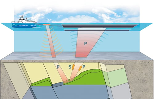
Figure 8-1.EPS Principles of 3D seismic surveys. P = P-wave, S = S-wave
Source StatoilHydro
To reduce conflicts of interest between the fisheries industry and the petroleum industry, environmental and fisheries-related requirements are included in the licensing procedures for new blocks. These include a requirement to take special account of fisheries activities and the possible presence of marine organisms when planning drilling activities. Steps must be taken to inform interested parties of such plans prior to exploration drilling. When planning seismic surveys, licensees must take special account of fisheries activities and the presence of marine organisms at critical stages in their life cycles. As a result of these requirements, restrictions on where and when seismic surveys are permitted have been introduced. Their purpose is to avoid seismic surveying at times when marine organisms are especially vulnerable, for example during spawning and spawning migration. Such restrictions already apply to some licences in the Norwegian Sea.
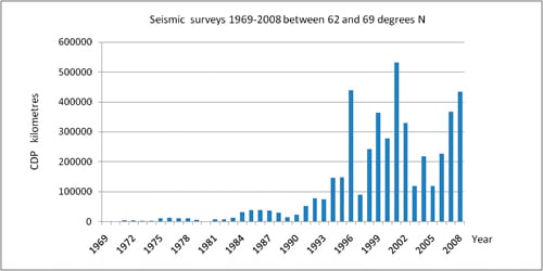
Figure 8-2.EPS Acquisition of seismic data between 62° and 69°N in the period 1969–2008
Source Norwegian Petroleum Directorate
There has been growing concern about seismic surveys, and the level of conflict of interest over different uses of the same areas seems to be rising. A working group with representatives from the Petroleum Directorate and the Directorate of Fisheries was established in September 2007 to review the problems and propose measures to deal with them. During its work the group maintained a dialogue with the industries concerned and other stakeholders. In its final report, which was presented in April 2008, the group proposed measures in the following areas:
administrative procedures – notification of seismic surveys, pipeline route surveys and other baseline studies, consultations;
announcements;
fisheries experts – role, number, organisation, competence/training, approval, contact with the authorities, reporting;
conflicts of interest related to different uses of the same areas;
tracking of seismic vessels;
potential for rationalisation.
As a result of the report, a steering group was established consisting of representatives from the Norwegian Petroleum Directorate, the Directorate of Fisheries and the Norwegian Pollution Control Authority. The committee was asked to review acoustic disturbance and other negative impacts on fish and marine mammals caused by seismic activity, with a view to establishing a recommended minimum distance from fishing activities, fish farming, and whaling and sealing. It was also asked to assess the need for legislative amendments and make proposals based on its conclusions concerning negative impacts. The group also proposed measures to regulate other testing activities.
The steering group presented its report on 30 April 2009.
8.1.2 Occupation of areas by the oil and gas and the fisheries industries
The development and operation of petroleum installations on the Norwegian shelf occupy areas of the sea for varying lengths of time. This also applies to seismic surveys, although only for limited periods. When activities are terminated, the area must be cleared and restored to its original state.
Norwegian legislation requires operators to establish safety zones round petroleum installations that project above the surface of the sea. A safety zone covers an area extending to a distance of 500 m from the outer limits of the installation. An exploration rig including its anchor spread occupies an area of about 7 km2 for a period of one to two months for each well. On the Norwegian shelf, safety zones occupy about 100 km2 of the total area of 675 571 km2 that is open for petroleum activities. The impacts of occupied areas depend greatly on the position of the safety zones in relation to important fishing grounds.
The spatial requirements of trawl fishing differ from those of fishing with passive gear such as gill nets and longlines. The area occupied by fisheries depends on the availability of the fish, on whether or not they are seasonal fisheries and to some extent on the fishing gear that is used.
The space required for gill netting and longlining depends both on the location of the fishery and on the type of vessel used. During the major seasonal fisheries off parts of the coast, the fishing grounds are utilised to the full, and if an area is occupied by the oil and gas industry, it is unavailable to the fishing industry. In such cases, it is not possible to compensate for the loss of fishing areas by intensifying efforts in other catch areas, since the fishing grounds are already fully utilised. At other times gill netting and longlining are less intensive, and in such cases the occupation of fishing areas is not expected to result in loss of catches.
Pelagic fisheries use purse seines or trawls to catch pelagic species such as herring and capelin. Spatial restrictions resulting from petroleum activities are not expected to lead to catch losses in these fisheries.
8.1.3 Fishing in the vicinity of subsea structures
Subsea structures do not normally occupy areas used by vessels fishing with conventional gear such as gill nets and longlines, or engaged in pelagic fisheries using purse seines and trawls, nor do they impede them in other ways. All subsea structures are required to be constructed in such a way that they can withstand mechanical damage caused by other forms of activity and do not damage fishing gear or otherwise interfere with fisheries activities to an unreasonable extent; they must be overtrawlable. However, in practice many fishing vessels avoid them for fear of trawl gear becoming snagged and damaged. After pipelaying has been completed, pipelines are no hindrance to fisheries using conventional gear such as gill nets and longlines or fisheries using purse seines and pelagic trawls. Only fisheries using bottom gear such as trawls and Danish seines can be impeded by pipelines on the seabed. However, there have been no reports of major problems linked with fisheries using Danish seines near these pipelines on the Norwegian shelf.
It is very unlikely that existing pipelines will be the cause of noticeable catch losses for trawlers fishing on the Norwegian shelf. Most of the problems experienced by trawl fisheries are caused by pipelines with rock armour or by external damage. Such pipelines can cause major disruptions in the operations of certain fisheries, and in some cases they cause problems by occupying space, damaging gear and reducing catch rates. Pipelines and cables that are buried in the seabed and stabilised do not interfere with fishing.
These problems can be further reduced by advance information about new developments, by inspections and by information about alterations to subsea structures.
8.2 Maritime transport and fisheries
In the management plan area, there is considerable fisheries activity over the whole of the continental shelf and along the continental slope towards the deep-water areas of the Norwegian Sea. This means that the route that most vessels follow along the coast from the Lofoten Islands to Stad at 62°N passes through or close to intensively used fishing grounds. Some fisheries operate year round, with vessels scattered over the whole area, while others are seasonal fisheries, with large concentrations of fishing vessels in certain areas.
A considerable proportion of the ship traffic into and out of the Norwegian Sea passes Stad, most of it at distances within 25 nautical miles of land, and traverses areas that are intensively fished at certain times of year. The risk of collisions and accidents involving loss of fishing gear rises with increasing traffic density. It might be necessary to establish traffic lanes or other routeing measures in this area in order to divert high-risk traffic further away from the coast.
Conflicts can arise between the fisheries and maritime transport if vessels sail through or very close to fishing grounds, particularly during the seasonal fisheries, when there are large concentrations of fishing vessels. Problems may also arise in areas where fixed gear is used at certain times of year.
The International Regulations for Preventing Collisions at Sea apply to all vessels on the high seas, whether they are fishing vessels, cargo vessels, leisure craft or other vessels. Under the international regulations, vessels that are under way are required to keep out of the way of vessels that are engaged in fishing. However, fishing vessels are obliged to display signals showing that they are engaged in fishing. They must also keep watch and show due care in order to avoid collisions. This is also important to ensure safe and predictable conditions for navigation.
Coastal states have the right to establish mandatory and recommended routeing and traffic separation schemes inside their own territorial limits. These help to increase the predictability of general traffic movements for all vessels, including fishing vessels, and thus also help to reduce the risk of collisions between fishing vessels and other ship traffic.
Outside territorial limits, mandatory and recommended routeing and traffic separation schemes must be approved by the IMO. Plans for the establishment of routeing and traffic separation schemes outside territorial waters take account of fisheries activities and the sailing patterns of fishing vessels, as well as other traffic and activities such as petroleum activities.
8.3 Maritime transport and petroleum activities
The risk of conflict between these sectors is mainly related to wrecked or drifting vessels colliding with installations, and anchor damage to pipelines.
However, experience from the North Sea shows that there is little conflict between petroleum activities and maritime transport. Most sailing routes are positioned well away from petroleum installations, and the probability of a vessel colliding with an installation is low. Only two collisions with ships have been registered by the Norwegian oil industry, and the ships were not being used in connection with petroleum activities.
Should a collision take place, it is very unlikely to result in the breakdown of an installation, a broken riser pipe or a blow-out. Stringent standards have been set for the design of load-bearing structures, and there must be at least two independent physical barriers between the reservoir and the surface. For a major blow-out to occur, both barriers must fail.
Petroleum legislation sets strict safety standards, and activities are monitored very closely by operators and authorities. A safety zone is established round every petroleum installation that projects above the surface of the sea. The purpose is to keep a safe distance between the installations and general maritime transport and other activities. The health, environment and safety legislation gives operators both a right and an obligation to prohibit traffic in safety zones and the regulations require safety zones to be monitored to ensure early intervention if there is a danger of collision. They also require that an emergency response system should be established that is designed for the types of hazards and accidents that may arise.
When mandatory or recommended routeing and traffic separation schemes are being planned outside the territorial limit, the position of petroleum installations are taken into account, so that the location of traffic lanes minimises conflict with petroleum activities and does not increase the risk of collisions. Surface installations are not permitted in traffic lanes.
Pipelines are shown on navigation charts. It is therefore very unlikely that under normal circumstances a vessel will drop anchor over a pipeline. This could, however, happen as a result of a navigation error or in a shipboard emergency, and the possibility cannot therefore be ruled out.
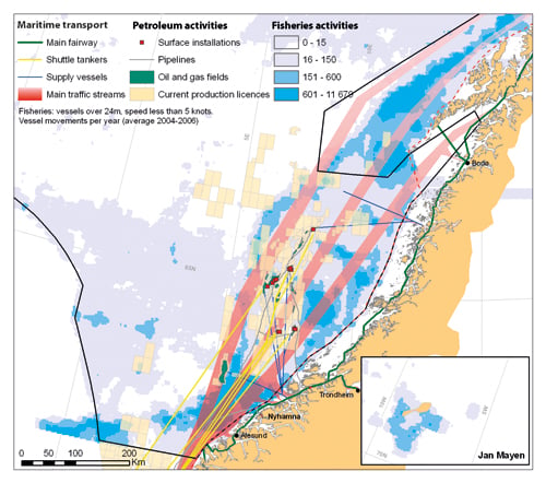
Figure 8-3.EPS Overview of maritime transport, petroleum activities and fisheries activities in the Norwegian Sea
Source Directorate for Nature Management/Coastal Administration/Norwegian Petroleum Directorate
8.4 Offshore wind power and other industries
8.4.1 Wind power and fisheries
Large-scale offshore wind farms will occupy relatively large areas. The distances between wind turbines may be as much as 1 km, and wind farms may contain as many as 50–100 turbines. The turbines are linked by a network of power cables on the seabed and these are joined to a cable that transmits the generated electricity to shore. It may be necessary to impose restrictions on traffic, passage and other activities in the area occupied by a wind farm. The nature of the restrictions is unclear, since no offshore wind farms have yet been established in Norway. In Denmark there is no general prohibition on traffic in or through wind farms, nor is there a general prohibition on fishing in Danish offshore wind farms, but there are restrictions on fishing methods, for example trawling.
Studies conducted in Denmark and Sweden indicate that offshore wind turbines do not frighten away fish in the operational phase, except when noise levels are higher due to high wind speeds. Some findings indicate that offshore turbines may to some extent function as artificial reefs, and thus attract fish. However, wind power production will occupy sizable areas, and this must be weighed against the needs of maritime transport, fisheries and other maritime activities.
Knowledge about important fishing grounds and shipping lanes will be of crucial importance in planning offshore energy production. The authorities can introduce spatial planning processes to ensure that energy production takes place in areas where the potential for conflict with fisheries and maritime transport is low enough to be acceptable.
Offshore power cables will have to be buried in the seabed or covered by rock armour so that they are overtrawlable. The presence of cables will therefore not make it necessary to introduce formal restrictions on fishing. However, it is known that armoured cables can damage fishing gear. Less rock is required for power cables than for pipelines, but the risk of damage cannot be excluded.
Currently there is no legislation regulating the establishment of wind power production outside the baseline, and this situation must be remedied before areas can be opened for development. The Ministry of Petroleum and Energy is holding consultations on a draft Marine Energy Act, which provides for procedures for evaluating the different interests.
8.4.2 Wind power and the petroleum industry
All petroleum exploration licences for the Norwegian Sea are for areas with waters deeper than 100 m, and with current technology wind turbines cannot be mounted on the seabed at depths of more than 100 m. This means that there would be no direct conflicts of interest between fixed petroleum installations on the seabed and seabed-mounted wind turbines over use of the same area. Since the location of wind farms is flexible with regard to existing petroleum installations and to shipping lanes between oil and gas fields and shore, conflicts of interest over use of a particular area are unlikely to arise in the future either. In addition a requirement could be imposed that wind turbines may not be mounted in areas where they would directly impede the establishment of petroleum installations.
8.4.3 Wind power and maritime transport
Any conflicts of interest arising between these two industries would be over competing uses of the same area or risk of collisions.
The degree to which offshore wind farms would come into conflict with maritime transport will depend on the location and number of turbines and the size of the area occupied. A large-scale wind farm may occupy an area of about 200 km2, and such installations in the vicinity of shipping lanes or maritime transport routes could increase the distances sailed and thereby reduce the competitiveness of maritime transport. However, the difference is unlikely to be noticeable unless a sizable number of large-scale wind farms are established in the vicinity of shipping lanes, and wind power development on this scale is not expected to take place during the period up to 2025.
Given the above restrictions in terms of depth and distance from shore for seabed-mounted wind turbines, there are few parts of the management plan area that are suitable for wind power development. Seabed-mounted turbines are therefore only expected to occupy a relatively small area during the period covered by the management plan, and the impacts on maritime transport will be small and localised.
If there are important shipping lanes or transport routes in the area where a wind farm is planned, this may reduce location flexibility for the wind farm.
The risk of conflicts of interest between wind farms and maritime transport can be reduced by making accurate surveys of shipping lanes and transport routes, by marking wind farms on charts and by drawing up legislation that sets out clear procedures for siting wind farms. Normally plans for a wind farm can be adjusted to coastal traffic routes. The distance between wind turbines will be up to 1 km, which allows for shipping lanes to pass right through a wind farm. Furthermore, ships usually sail in deep waters, while initially wind farms will have to be established in shallow waters. The development of technology for building floating wind turbines could alter this situation over time.
Footnotes
Report on the effects of seismic sound on fish and marine mammals by an expert group for the Norwegian Petroleum Directorate, the Directorate of Fisheries and the Norwegian Pollution Control Authority, 2008