3 State of the environment – status and trends
The environmental status of the North Sea and Skagerrak has been improved over the past few decades, but still gives cause for concern and is unsatisfactory in many ways. These waters are naturally rich and productive, but there are various types of pressure on the environment, which entail considerable management challenges.
This management plan area differs from the Norwegian Sea and the Barents Sea–Lofoten area in being much more strongly influenced by human activity.
Climate change and ocean acidification are expected to result in major ecosystem changes, and may intensify the impacts of other pressures. Rising temperatures have already resulted in changes in the species composition and distribution of zooplankton. These may affect food supplies for fish, seabirds and marine mammals and thus have impacts on their populations. Higher sea temperatures have also allowed new fish species from further south to expand into the management plan area.
Releases of pollutants from point sources have been reduced, but there are still considerable inputs of hazardous substances, mainly from sources outside the management plan area. Moreover, concentrations of marine litter in the North Sea are among the highest recorded in the Northeast Atlantic.
Levels of hazardous substances in seafood from the North Sea and Skagerrak are generally low, but are somewhat higher than in the Norwegian Sea and the Barents Sea–Lofoten area. The levels of certain substances in some species are cause for concern.
Fishing pressure on a number of stocks in the North Sea was previously too high. Together with natural fluctuations and climate change, this has reduced some spawning stocks to critical levels, and there is a risk that other stocks are not being harvested sustainably. The impacts of bottom trawling can be seen in many areas of the seabed. Along the edge of the Norwegian Trench, where the same area may be bottom trawled up to 20 times a year, the composition of the benthic fauna has been altered.
A number of seabird populations are declining, including the common gull, black-legged kittiwake, common tern, Atlantic puffin and common guillemot. Pressures on seabirds include climate change, changes in food supplies, and human activity. However, great cormorant numbers have increased along the Skagerrak coast.
Water quality is good in the coastal current, but eutrophication and sediment deposition may affect water quality in some areas along the coast and in fjords.
This chapter gives an account of the environmental status of ecosystems in the management plan area, including the pollution situation and the status of species and habitats. It also describes the particularly valuable areas that were identified in the scientific basis for the management plan, and which are particularly important for biodiversity and biological production. Environmental pressures and impacts from various sectors and the cumulative environmental effects on ecosystems are discussed in Chapters 6 and 7.
3.1 The physical/chemical environment and climate change
3.1.1 Oceanographic conditions
The North Sea–Skagerrak management plan area covers an area of 142 100 km2, and is thus considerably smaller than the other two management plan areas, the Norwegian Sea (1.17 million km2) and the Barents Sea–Lofoten area (961 000 km2). The management plan area is bounded by other countries’ territorial waters and economic zones.
The North Sea is generally shallow, reaching the greatest depths (somewhat more than 100 metres) in the northerly parts of the basin. The Norwegian Trench separates Norwegian coastal waters from the shallower parts of the North Sea further west and south. The coastal side of the Norwegian Trench slopes steeply to the deepest water just off the Norwegian coast, while the offshore side rises more gently to the North Sea Plateau west and south of the Trench. The Norwegian Trench reaches its greatest depth of more than 700 m in the Skagerrak south of Arendal. A shallower area off the Jæren area of Norway near Stavanger separates the deeper Skagerrak stretch of the Trench from the northern part.
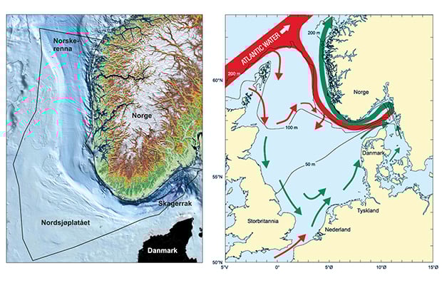
Figure 3.1 a) The bottom topography of the management plan area. b) The most important features of circulation patterns and water depths in the North Sea and Skagerrak. Red arrows: Atlantic water. Green arrows: Coastal water.
Source a) Geological Survey of Norway and Norwegian Mapping Authority, b) Institute of Marine Research.
Water circulation in the management plan area is strongly influenced by the topography. More saline, nutrient-rich Atlantic water flows in from the north and into the Skagerrak along the western slope of the Norwegian Trench. Together with water from the northern North Sea, it sinks to form the deep water. At the surface, outflowing, low-salinity Baltic Sea water mixes with water from the southern part of the North Sea. Together with runoff from land, this forms a wedge-shaped surface current off the coast, which flows southwestwards past Lindesnes (the southernmost point of Norway) and continues northwards along the coast. This current system is called the Norwegian coastal current. It shows seasonal variations in velocity, extent and depth. In summer, the coastal water may spread far across the North Sea Plateau, whereas in winter it is concentrated in a relatively narrow wedge-shaped band off the Norwegian coast. The quantity of water in the coastal current also varies, but the average transport off Western Norway is of the order of 1 million m3 per second. The water masses of the North Sea are strongly influenced by wind. For example, strong northerly winds in the Jæren area near Stavanger and further east push surface water away from the coast, causing upwelling of colder nutrient-rich water to the surface, where the nutrients act as fertiliser for phytoplankton growth. The patterns of water circulation in the Skagerrak bring nutrient-rich deep water to the surface in the central parts of the Skagerrak, which is one important reason for the high level of biological production here.
The Skagerrak coast has relatively warm summers and cold winters, and freshwater inputs have most influence in this part of the management plan area. Most of the freshwater originates in the Baltic Sea, but Norway’s largest rivers also drain into the Skagerrak, and carry large volumes of freshwater.
The coastline from Lindesnes northwards to the boundary of the management plan area at the Stad peninsula includes some of Norway’s largest and deepest fjords. Some stretches of coastline are sheltered by hundreds of islands and skerries, whereas others, for example the Jæren area near Stavanger, are exposed to the open sea. Annual temperature variations are smaller than along the Skagerrak coast, but the tidal range is greater and increases northwards. There are locally large inputs of freshwater in some fjords, but the coastal current itself is less influenced by freshwater than it is along the Skagerrak coast, and is not as strongly affected by long-range transport of nutrients. The general picture is that land-based activities, waste water discharges and industrial pollution put less pressure on this area than on the Skagerrak.
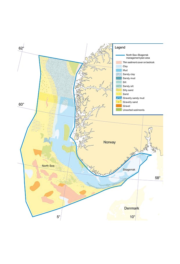
Figure 3.2 Sediment types in the management plan area.
Source Norwegian Mapping Authority and Geological Survey of Norway.
3.1.2 Sediments and landforms
Marine sediments are formed when unconsolidated material such as gravel, sand, mud and clay is deposited on the seabed. The Norwegian Trench is the most important sedimentation area in the North Sea. Particularly in the Skagerrak and south of Lindesnes, large quantities of fine material (mud) transported with the currents from the southern parts of the North Sea are deposited, together with some material from the coastal zone. There is less sedimentation in the northern part of the Norwegian Trench. In shallower water over the slope between the Trench and the North Sea Plateau, the bottom sediments become gradually coarser, and in the transitional zone between the Trench and the Plateau they can be categorised as muddy sand. The upper part of the slope clearly shows the influence of stronger bottom currents, but also has deposits of fine sand transported from the Plateau.
Sandy sediments dominate the North Sea Plateau south of the Viking Bank (60°45’N). North of the Viking Bank, the bottom topography is more varied, with moraine ridges and hollows. The sediments are also more varied here, ranging from mud via sand to gravel, with boulders and bedrock appearing locally.
3.1.3 Natural conditions in the North Sea and Skagerrak
The composition and thickness of the bottom sediments have a considerable influence on the distribution of marine habitat types and benthic communities. Different soft bottom benthic communities consisting of crustaceans, molluscs, echinoderms and polychaetes are found, depending on the type of bottom substrate (sand, clay, etc). Certain sandy-bottom areas are important habitats and spawning grounds for sandeels. In some areas, moraine or hard clay deposits are exposed on the seabed, or covered by a layer of gravel and/or sand.
The topography along the coast is varied and complex, with a wide variety of subsea habitat types. There are sheltered fjords, islands and skerries, stretches of exposed coastline, and variations between deep and shallow water and between areas with strong currents and those with little current. Substrates can be divided into two main types: hard bottom, such as bedrock and boulders, and soft bottom, such as sand and mud. Coastal waters have a rich flora and fauna, including both sessile and free-swimming organisms, which vary in size from microscopic plankton to seals and whales. Many organisms are stationary, and spend their entire life cycle in coastal waters. Others have their spawning, nursery or feeding grounds along the coast but spend long periods far out to sea. Macroalgae function as the trees, bushes and flowers of coastal waters, and are important nursery habitats for many organisms. There are three main groups of macroalgae: green, red and brown algae. The brown algae include the species commonly known as wracks and kelps. Macroalgae provide food and shelter for small organisms that are vulnerable as prey for larger species. The microscopic algae, phytoplankton, drift in the water column and make an even greater contribution to biological production along the coast. The phytoplankton is a vital source of food for zooplankton and other animals every spring and summer. In recent years, there has been growing awareness of the need to maintain species and habitats and a healthy coastal environment, and to avoid overharvesting resources and reduce pollution.
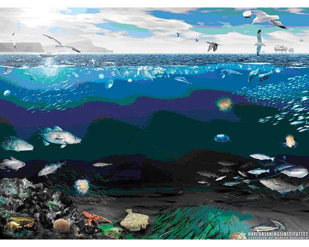
Figure 3.3 The pelagic and benthic ecosystems of the North Sea.
Source Institute of Marine Research.
3.1.4 Climate change and ocean acidification
Climate change and ocean acidification may result in large-scale changes in marine ecosystems. The capacity of seawater to absorb heat and carbon dioxide (CO2) is important for the role of the oceans in regulating greenhouse gases. The oceans have now absorbed so much heat that the rise in the average temperature at the surface and somewhat further down the water column is beginning to have marked effects. And the capacity of the oceans to absorb CO2 is not unlimited either. In recent decades, the rising sea temperature has resulted in considerable changes in the quantity and species composition of zooplankton in the North Sea, and in particular in a substantial decline in the amount of the copepod Calanus finmarchicus.
Textbox 3.1 Calanus finmarchicus and rising sea temperature
Rising sea temperatures have resulted in major changes in the quantity and species composition of zooplankton in the North Sea, and a particularly large decline in the amount of the copepod Calanus finmarchicus. This is a key zooplankton species in central and northern parts of the North Sea, where it is an important food species for several types of fish and for the larval stages of the most important prey species for seabirds.
The quantity of C. finmarchicus in the North Sea has declined greatly in the past 10–20 years, and has dropped by 70 % since the 1960s. At the same time, Calanus helgolandicus, a closely related species that prefers warmer waters, has been increasing in numbers, and its distribution has expanded all the way to the Norwegian Sea. This species spawns later in the year and is less nutritious for fish and seabirds than C. finmarchicus.
Changes in species composition, size distribution and production cycles of zooplankton have effects on animals at higher trophic levels in the food web. For example, C. finmarchicus spawns early in spring, and quantities of its early larval stages reach a maximum when the larvae of spring-spawning fish species have hatched. Fish larvae are dependent on finding the right kind of food at the right time if they are to survive. A decline in C. finmarchicus and an increase in plankton species that spawn later in the season, such as C. helgolandicus, may result in a mismatch between spring-spawning fish and their prey, and thus have a direct impact on recruitment to stocks of these fish species.
Both C. finmarchicus and C. helgolandicus are near the edge of their distribution areas in the North Sea. They are therefore particularly sensitive to temperature change, and can be used as indicators of climate change.
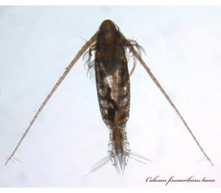
Figure 3.4 The copepod C. finmarchicus
Source Institute of Marine Research
Climate change may have impacts on marine ecosystems at a number of different levels, and may affect them in various different ways at the same time. It may have direct or indirect impacts on individual species or on trophic levels, and it is also possible that major ecosystems will be pushed past tipping points, so that they shift suddenly to a new state.
Carbon dioxide concentrations both in the atmosphere and in the oceans have risen due to anthropogenic greenhouse gas emissions. CO2 reacts with water to form carbonic acid, making the seawater more acidic (lowering the pH). As a result, the average pH of ocean surface water is now about 0.1 pH units lower than the pre-industrial level. Calculations for the southern part of the North Sea indicate a drop of 0.35 pH units in the period up to 2100. In future, ocean acidification may have far-reaching impacts on ecosystems in the management plan area (see Chapter 7.3.8).
The hydrography of the North Sea is complex, since there are several different water masses of different temperature and salinity. Because of this, pH varies widely from one geographical area to another and also varies with water depth. In the deeper water layers, degradation of organic material gives rise to a higher content of CO2 and thus lower pH. There are also large natural fluctuations in pH during the year as a result of processes such as seasonal algal growth and decomposition of organic material. Long time series of measurements over many years are therefore needed to identify long-term trends in pH levels. There are no long time series for the management plan area, but measurements made in the Kattegat since 1993 show a decline in pH in surface water. This indicates that ocean acidification is already taking place. In 2010, monitoring of ocean acidification was started in Norwegian waters, including the eastern part of the Skagerrak.
3.2 Pollution affects all parts of ecosystems
Pollution problems in the North Sea and Skagerrak have changed character in recent decades. Previously, the main task was to reduce pollution from point sources, some of which were large, and especially from land-based industry. Releases from these sources have been substantially reduced, and diffuse releases from sources on land, such as runoff from agricultural areas and other surface waters, together with inputs with air and ocean currents, now make a relatively larger contribution to the total pollution load in the management plan area.
The North Sea cooperation and work within OSPAR to achieve objectives for the marine environment have resulted in substantial reductions in inputs and environmental levels of oil, nutrients and heavy metals. Inputs of many other hazardous substances have also been reduced. Despite this, pollutants are still entering the North Sea and Skagerrak through long-range transport. These pollutants are substances that can be transported for long distances and that largely originate outside Norway’s borders. In addition, diffuse sources within Norway add to the pollution load. Hazardous substances are present in marine organisms, including seabirds and marine mammals. All these factors mean that the pollution status of the management plan area is not satisfactory. Furthermore, in addition to its impacts on marine species, pollution may have negative consequences for commercial activities that are based on marine resources and a clean environment, such as fisheries, aquaculture and tourism.
3.2.1 Hazardous substances
Hazardous substances are substances or groups of substances that are toxic, persistent and liable to bioaccumulate, and other substances or groups of substances that give rise to an equivalent level of concern. The latter include substances that do not meet all three criteria but have other properties that give rise to an equivalent level of concern, such as endocrine disruptors.
In the case of the most persistent hazardous substances, the slow rate of degradation means that it takes a long time before emissions reductions lead to a reduction of environmental levels of the substances. In other cases, the main problem is that such large quantities of hazardous substances are used and released that environmental levels continue to increase even though the substances are less persistent.
Pollution levels in the management plan area vary between substances, geographical areas and sample media (water, fauna, algae, sediment). Substances that are bioaccumulative have the most serious impacts on species at higher trophic levels such as seals and seabirds. The pollution load in some of these species is so high that it can cause damage to the nervous system and disrupt reproduction.
Calculations show that long-range transport of pollutants with air and ocean currents is the most important source of hazardous substances in the Norwegian part of the North Sea and Skagerrak. Since these waters are downstream of pollution sources, the currents carry polluted water masses from other areas into the management plan area. The Norwegian part of the North Sea and Skagerrak is therefore influenced by activities and inputs from other countries. Hazardous substances are spread with the ocean currents, and the levels measured in the open sea are therefore relatively low. The exception is sedimentation areas in the Norwegian Trench, where elevated levels of polyaromatic hydrocarbons (PAHs) have been measured. Modelling results indicate that levels of hazardous substances in seawater are highest near the coast of the Skagerrak, in eastern parts of the Skagerrak and in the southern part of the North Sea. This is explained by inputs from rivers and the coastal zone in other countries around the North Sea.
Little is known about the fate of hazardous substances once they reach the coastal current and the open sea, but given what is known about their properties and their presence in the water masses, there is reason to believe that these substances may have adverse impacts on the state of the environment in the management plan area.
3.2.2 Hazardous substances in seafood and seafood safety
Hazardous substances can pose a risk to health if they are consumed in seafood. Levels of hazardous substances in seafood from the North Sea and Skagerrak are generally low, but are somewhat higher than in the Norwegian Sea and the Barents Sea–Lofoten area. The content of certain substances in a few species is high enough to give cause for concern. Levels of dioxins and dioxin-like PCBs (polychlorinated biphenyls) in the liver of a relatively high proportion of the cod in the management plan area exceed the maximum levels permitted in fish liver. Levels of non-dioxin-like PCBs in cod liver also exceed the maximum permitted levels in a substantial proportion of cod from the North Sea and Skagerrak. Levels appear to be higher in the Skagerrak than in the North Sea.
If levels of dioxins and PCBs in cod liver exceed the maximum limits, the products may not be marketed for human consumption. To protect the most vulnerable groups in the population, the Norwegian Food Safety Authority has issued a general warning that children, women of childbearing age and pregnant women should not eat fish liver. Levels of dioxins and dioxin-like PCBs in cod liver from fjords and harbour areas are very high, and considerably higher than in cod from the open sea. The Food Safety Authority has therefore issued general advisories to the whole population against the consumption of liver from fish caught by private individuals inside the baseline. In addition to this, advisories on the consumption of fish and shellfish are in force today for 16 harbours and fjords in the North Sea–Skagerrak area. They are related to the presence of lead, cadmium, mercury, dioxins and furans, PCBs and PAHs.
Levels of mercury in tusk fillets from the Skagerrak have also been found to be just below the maximum permitted level. Mercury levels in tusk fillet from the North Sea were lower than in the Skagerrak and well below the maximum permitted level, but higher than the levels found in the Norwegian Sea and Barents Sea.
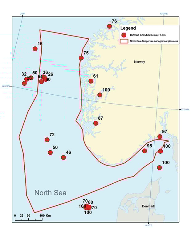
Figure 3.5 Percentage of cod found to contain concentrations of total dioxins and dioxin-like PCBs in the liver exceeding the statutory maximum level for human consumption set by the EU and Norway.
Source National Institute of Nutrition and Seafood Research.
Animals and people often exhibit different levels of tolerance to hazardous substances, and their exposure to these substances also differs. Different systems have therefore been put in place to protect people and the fauna against the possible adverse impacts of hazardous substances (see Box 3.2).
Textbox 3.2 Differences between maximum permitted concentrations of hazardous substances in seafood and according to environmental quality standards
The concentration of a hazardous substance in an organism may be below the maximum permitted level for seafood, but higher than the level set in the environmental quality standard for biota.
The maximum permitted levels of contamination in seafood are intended to protect people. They set out the maximum permitted amounts of particular hazardous substances in seafood that is marketed for human consumption. The maximum levels are set in EU legislation and have with few exceptions also been made applicable in Norway. They are intended to prevent products containing levels of contaminants that could have negative effects on health from reaching consumers.
The environmental authorities (the Climate and Pollution Agency) also use a classification system, which is intended to protect the environment. The limits in this system were established to indicate environmental quality status in fjords and coastal waters, but are now being revised to adapt them to the EU’s Water Framework Directive. The revised classification system takes the most vulnerable elements of the ecosystem as a starting point, and sets maximum limits for concentrations of pollutants on the basis of the levels that have been shown to have environmental impacts. These thresholds are called Environmental Quality Standards (EQS). Both the EU and Norway are working on the determination of further EQS for different groups of organisms.
Thus, the levels of hazardous substances measured in an organism may be so high that there is a risk of environmental impacts, while at the same time the organism may be safe for people to eat. For example, levels of mercury in cod fillet are in many cases higher than the EQS set under the Water Management Regulations, but at the same time below the seafood safety limit.
3.2.3 Radioactive substances
Levels of radioactivity in the North Sea and Skagerrak are generally low, but higher than in Norway’s other sea areas. Inputs from the Chernobyl accident in 1986 are still an important source of radioactive pollution in Norway’s coastal and sea areas. Caesium 137 mainly enters the management plan area with contaminated water from the Baltic Sea, and the highest concentrations are therefore found in the Skagerrak (see Figure 3.6). There have been sporadic analyses of radioactive isotopes of radium and thorium in bottom sediments and the water column around selected petroleum installations, and elevated levels have been observed at certain sites.
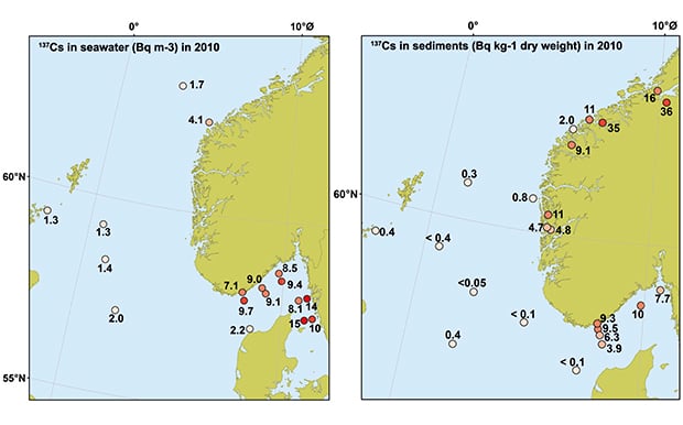
Figure 3.6 Levels of caesium 137 in sediments and seawater from the North Sea and Skagerrak in 2010
Source Norwegian Radiation Protection Authority
3.2.4 Eutrophication and sediment deposition
Large inputs of nutrients to coastal and fjord areas result in eutrophication, which leads to excessive production of organic material. Decomposition of organic matter can lead to poorer oxygenation conditions in deep water. Dead organic matter sinks to the bottom, and together with particulate matter in runoff from land this can result in sediment deposition on the seabed in sheltered areas. Eutrophication and sediment deposition as a result of inputs of nutrients and organic matter primarily lead to problems in coastal waters and fjords. In 2007, an overall evaluation of eutrophication status along Norway’s Skagerrak coast was carried out in accordance with OSPAR’s Common Procedure and classification system, based on data from 2001–05. This identified the inner coastal waters (roughly the fjords and waters inside the coastal islands and skerries) along this entire stretch of coastline as being a Problem Area with respect to eutrophication. Knowledge of environmental status along the coast of Western Norway is inadequate, but new calculations indicate that discharges of nutrients and organic matter are not having impacts at regional level. However, studies have revealed local effects. The eutrophication status of the outer zone of coastal waters and the open sea is considered to be good.
Local and regional changes in coastal waters and fjords may alter conditions in important nursery areas for fish and other marine animals that spend part of their life cycle in or near the management plan area. Rising sea temperatures combined with inputs of nutrients and sediment deposition are probable explanations for the loss of sugar kelp from much of the inner coastal waters of the Skagerrak (see Chapter 3.3.3).
3.2.5 Marine litter – a global environmental problem
Large quantities of litter enter the world’s oceans every year, and are transported with ocean currents over great distances and across national borders. Plastic, glass, rubber and other long-lived materials can persist in the environment for many years. There are many different sources of marine litter, and their environmental impacts vary.
OSPAR has carried out beach litter surveys to assess the litter problem in the Northeast Atlantic. In general, high levels of beach litter were registered, although there were variations from one year to another. Concentrations of marine litter in the North Sea area are among the highest recorded in the Northeast Atlantic.
Plastics account for only 10 % of the annual quantity of waste generated worldwide, but because of their properties and slow rate of degradation, they make up the largest proportion of the accumulated litter in the sea. This is also the case in Norwegian waters (Figure 3.7). Plastics are gradually fragmented into smaller and smaller pieces, and finally form extremely persistent microplastics. It has been shown that microplastics may be present in high concentrations in seawater.
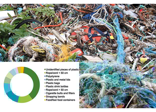
Figure 3.7 The ten marine litter items most frequently found during the annual beach clean-up day in 2012
Source Hold Norge rent (Keep Norway Clean). Photo: Oslofjordens friluftsråd.
So far, only one pilot study of microplastics has been carried out in Norway, in which samples were taken at stations between Arendal and Hirtshals in Denmark. Low concentrations were found in the open sea, but the possibility that this is a more serious problem closer to the coast and in enclosed fjords cannot be excluded.
Much of our knowledge about marine litter comes from beach litter surveys, studies of the contents of seabird stomachs and video recordings of pipelines on the seabed. Even though marine litter has been an obvious problem for a long time, our knowledge of its environmental impacts is very limited. In 2011, the Directorate for Nature Management established a network of seven localities for monitoring beach litter. Two of these localities are close to the management plan area (Kviljo in the Listastrendene area and Akerøya in Ytre Hvaler national park, Outer Oslofjord). Monitoring at these localities forms part of the international cooperation on marine litter, and the data are reported to OSPAR. Data series from these localities and similar monitoring programmes in other countries will provide information on the scale and sources of marine litter in the management plan area.
3.3 Specific ecosystem components
3.3.1 Phytoplankton and zooplankton
Phytoplankton
Phytoplankton are microscopic, single-celled organisms that drift in the water column. Like other plants, they need light and nutrients to grow, in other words to divide and form new cells. At our latitudes, there is only enough light for plant growth in the upper 50 metres of the water column. In spring, runoff of freshwater (which is lighter than the saline seawater) increases, and the temperature of the surface water rises. This results in the formation of a relatively stable surface layer that is ideal for phytoplankton growth. Large algal blooms colour the sea surface, the colour depending on which species is involved. The spring algal bloom is dominated by diatoms, which require silicate as a nutrient in addition to nitrate and phosphate. Large algal blooms can be clearly visible, and may for example make the water in popular bathing areas appear discoloured and almost opaque. But all the organisms that feed on this first trophic level of marine food chains benefit from large algal blooms. Inputs of nutrients increase phytoplankton production and can result in negative impacts such as oxygen depletion in deeper water layers as surplus quantities of phytoplankton sink to the seabed where the dead cells are broken down, consuming oxygen in the process. The inner parts of fjords with shallow sills are particularly vulnerable because turnover of the bottom water is slow.
Textbox 3.3 The 1988 algal bloom
Some phytoplankton species are toxic and can occur in such high concentrations that they cause widespread mortality of fish and benthic animals. This happened on an unusually large scale in summer 1988, when a massive bloom of the unicellular alga Chrysochromulina polylepis (Prymnesium polylepis) resulted in high fish mortality along the Norwegian coast. The bloom started in the Kattegat, and the algae were carried in the coastal current towards Western Norway. Other algae and a wide range of marine animals were killed or harmed in an area stretching from the west coast of Sweden to Bømlo, between Stavanger and Bergen. Salmon farmers suffered major losses, but mortality was also recorded in wild fish and benthic animals.
Although the main trigger of this particular algal bloom has not been identified, a considerable nutrient imbalance between phosphate and nitrate was observed shortly before the bloom started. Moreover, there was little silicon in the water before the bloom began, which prevented a bloom of «harmless» diatoms. Together with extraordinary inputs of nutrients to the North Sea from the large rivers on the continent and inputs with the coastal current from the Baltic Sea, this may explain why there was such a large-scale bloom extending over such a large area.
After this «algal disaster», a number of steps were taken to reduce inputs of nutrients to the sea.
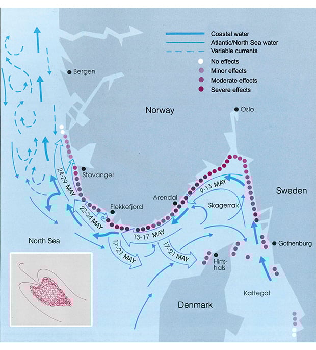
Figure 3.8 Extent and development of the algal bloom. The inset shows a single algal cell.
Source Pedersen, Walday, Oug. Norwegian pollution monitoring programme. Report 475/91.
Zooplankton
In the past 25 years, considerable changes have been observed in the quantity and species composition of zooplankton in the North Sea. As a result of the rising sea temperature, warm-water species have expanded their distribution more than 1000 km northwards over the past 50 years, while there has been a reduction in the quantity of cold-water species. One clear example of the changes is the 70 % decline in the biomass of the copepod Calanus finmarchicus in the North Sea since the 1960s. The biomass of the related species C. helgolandicus has increased in the same period (see Box 3.1).
Changes in the species composition, size distribution and production cycles of the zooplankton have implications for higher trophic levels in the food web.
Because about 70 % of the water masses of the North Sea flow into the Skagerrak and then back out of the North Sea as part of the Norwegian coastal current, monitoring in the Skagerrak can give a good picture of conditions in the North Sea and how they are changing. Since 1994, the Institute of Marine Research has taken samples of zooplankton along the Skagerrak coast as part of the Climate and Pollution Agency’s coastal monitoring programme. The results show a steep decline (80 %) in the biomass of small plankton species since 2003. The zooplankton community consists of a wide range of different species, and copepods of the genus Pseudocalanus are considered to be the most important species in the food chain in the North Sea after the Calanus species. However, these species are so small (1.0–1.5 mm) that the total biomass of Pseudocalanus is smaller than that of Calanus.
3.3.2 The seabed and benthic fauna
There is a rich benthic flora and fauna in the North Sea, Skagerrak and adjoining coastal areas. The distribution of benthic animals depends on the sediment type and water depth.
The species composition of the benthic fauna shows a split between more southerly assemblages, dominated by free-swimming organisms such as starfish and crustaceans, and more northerly assemblages, where sessile organisms such as sea anemones and sponges tend to dominate. The boundary between the two types of assemblages follows the 50-metre depth line through the central part of the North Sea. The number of species is higher in the north than in the south, and the biomass is higher near the coast than further out to sea. Temperature variations and current conditions also influence species diversity and density, because most benthic species have larval stages that drift in the water column. The benthic fauna is important food for fish such as cod, haddock and flatfish, and benthic species feed on organic matter that sinks to the seabed.
We know a good deal about bottom types in the North Sea, but relatively little about the benthic and epibenthic fauna. This applies particularly to the largest species, such as sponges, sea pens and corals. These species protrude from the seabed and are therefore most sensitive to bottom trawling and other forms of physical disturbance. Coral reefs, gorgonian forests and sponge communities have been found in Ytre Hvaler national park and the adjacent Kosterhavet national park in Sweden. This reef complex, which stretches across the Norwegian–Swedish border, has also been identified as a particularly valuable area (see Chapter 3.4). The gorgonian forests in the area consist mainly of the sea fan Primnoa resedaeformis, but several other species of soft corals also occur. Coral habitats have also been found on the western slope of the Norwegian Trench in the Tampen area, towards the northern boundary of the management plan area, but the size of the reef complex is not known. No other coral habitats have been reported in the North Sea and Skagerrak. However, currents in both directions along the coast result in exchange between the water masses in the North Sea and those further north in the Norwegian Sea.
The fauna of the bottom sediments has been better studied, and there are long data series from the coastal and offshore monitoring programmes. However, there is a lack of information about the links between the structure of benthic communities and their ecological functions (cycling organic matter and nutrients, biological production).
Benthic communities are found in both hard bottom habitats (boulders, rock and gravel) and soft bottom habitats (clay and mud). Results from the coastal monitoring programme show that the state of both hard- and soft-bottom habitats in the outer zone of coastal waters in the Skagerrak and off the coast of Western Norway is generally good. The benthic communities in the eastern part of the Skagerrak (outer Oslofjord) have been showing positive trends. This reflects the reduction in the nutrient content of water transported from areas such as the German Bight. Conditions within the coastal current vary greatly because of nutrient inputs from land. However, we know little about benthic communities in the management plan area other than those in coastal waters and around offshore installations. In areas that are repeatedly disturbed, for example near the slope of the Norwegian Trench, short-lived, opportunistic species will dominate at the expense of species that need more time to become established and reproduce.
Further south in the North Sea, it has been shown that slow-growing, sessile species such as molluscs have declined considerably, while free-swimming, fast-growing species, often crustaceans, are now dominant.
3.3.3 Kelp forests
Biodiversity and production are high in kelp forests, and they are often called the rainforest of the sea. The fauna is dominated by crustaceans and gastropods that move on and between the plants looking for food and shelter. Kelp forests are also important spawning, nursery and feeding areas for crustaceans, larvae and fish, and fish-eating seabirds often feed in these areas. Coastal cod spend the first winter of their life in these near-shore areas, and need the food and shelter they provide. The richness of kelp forests is illustrated by faunal densities in excess of 100 000 individuals per square metre. The invertebrate fauna plays an important role in nutrient cycles, since these animals live on the kelp and are in turn eaten by fish. Kelp forests also sequester large quantities of CO2.
The outer part of the kelp forest zone is dominated by Laminaria hyperborea, which in hard-bottom habitats forms a belt in the depth range 1–20 metres. Individual plants, however, may grow down to a depth of more than 30 metres. In more sheltered coastal areas and fjords, kelp forests are often dominated by sugar kelp (Saccharina latissima). L. hyperborea is harvested commercially from Rogaland to Nord-Trøndelag. The state of these kelp forests and the impacts of kelp harvesting are monitored annually. The results indicate that the kelp communities in the outer part of the kelp forest zone are in good and stable condition. The regrowth of kelp after harvesting seems to be generally good from year to year, and the activity is considered to be sustainable.
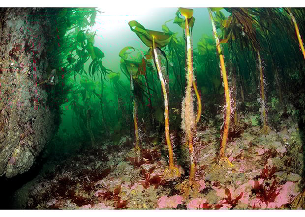
Figure 3.9 Kelp forest.
Source Photo: Erling Svendsen
Early in the 2000s, it was observed that sugar kelp abundance had declined since the mid-1990s along the coast of the Skagerrak and further west along the southwestern coast of Norway. In the period 2005–08, a project was carried out to investigate the scale and causes of the decline . The conclusion was that sugar kelp had disappeared from much of the Skagerrak coast (80 % of the coastline had lost its kelp forests), and from 40 % of stretches of the coastline of Western Norway. Sugar kelp had been replaced by smaller filamentous algae growing on a silt-covered seabed where the kelp was unable to become attached and grow. In areas where kelp forests are lost, many benthic and pelagic animal species also disappear. Food supplies for larger fish and seabirds are reduced, and many species such as coastal cod and crustaceans lose shelter. Several factors are believed to be behind the decline of sugar kelp in the Skagerrak since the 1990s, including higher inputs of nutrients, sediment deposition and rising temperatures. This is probably the first clear example in Norway of how several environmental pressures can work together and cause a dramatic shift in the state of an ecosystem.
In the 2011 Norwegian Red List for Ecosystems and Habitat Types, sugar kelp forests are classified as endangered in the Skagerrak and vulnerable in the North Sea, and kelp forest habitats generally are classified as near threatened.
There are signs that the state of sugar kelp forests is improving along the coast of Western Norway and to some extent along the Skagerrak coast. However, it is too soon to conclude whether this is a lasting trend.
3.3.4 Fish stocks
The North Sea can be roughly divided into four areas, each with a characteristic ecological profile. The northern part, which is 100–200 metres deep, includes the most important fishing grounds for Norwegian fisheries. Species caught here include adult cod, saithe, herring, mackerel, horse mackerel, haddock and Norway pout. In the central parts of the North Sea, there are fishing grounds for sprat, whiting and haddock. The eastern part, at depths of 50–100 metres, is a nursery area for herring and cod. There are also important areas of sandeel and flatfish habitat.
Fish stocks show wide natural fluctuations in size. Climate variability has particularly strong effects on shallow waters such as the North Sea, and this in turn influences migration and distribution patterns of fish stocks to varying degrees. Temperature changes can affect recruitment, individual growth and distribution patterns. The International Council for the Exploration of the Sea (ICES) issues updated advice for fish stocks every year. The most important species in the North Sea are saithe, mackerel, herring, sprat, blue whiting, Norway pout, sandeel, shrimps and cod. Sandeels, herring and sprat are important prey for marine mammals, other fish and seabirds, while Norway pout is an important part of the diet of other fish.
Cod
Cod in the North Sea are relatively stationary, and there are probably several spawning stocks. There are no clear boundaries between these, and spawning can take place throughout the North Sea. All North Sea cod is therefore managed as a single stock.
There has been heavy fishing pressure on North Sea cod for many years, and the spawning stock has been greatly reduced. Recruitment has been low, both because of the depleted spawning stock and because of the rise in the temperature of the North Sea. The spawning stock was reduced from about 250 000 tonnes in 1970 to well below the critical level (70 000 tonnes) in 1999, and the decline continued after 2000. However, a plan for rebuilding the stock has now been evaluated and approved by ICES, and the total allowable catches (TACs) that are now being set are considered to be sustainable. The status of the stock has improved in recent years, and the spawning stock is expected to rise above the critical level in 2013 for the first time since the 1990s. Of the TAC for the EU and Norway, 17 % is allocated to Norway.
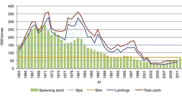
Figure 3.10 Changes in the spawning stock (1963–2012) and catches (1963–2011) of cod in the North Sea. Total catch = catches landed + discards. Blim: critical spawning stock reference point, Bpa: precautionary spawning stock reference point
Source Institute of Marine Research
Saithe
After hatching, juvenile saithe live close to the coast, and move out into the North Sea when they are three or four years old.
During the 1970s and 1980s, the spawning stock was depleted, reaching a minimum level of 100 000 tonnes in 1991. Since then, fishing pressure has been lower. The spawning stock has increased, and has been above the precautionary level since 1997. It is estimated at 235 000 tonnes in 2013. The stock is classified as sustainably harvested and as having full reproductive capacity.
Blue whiting
The blue whiting is a small pelagic gadid that is found throughout the Northeast Atlantic and is one of the most numerous fish species in the mesopelagic zone. Blue whiting feed mainly on crustaceans such as krill and amphipods, and are themselves important prey for saithe, Greenland halibut and pilot whales. The stock was reduced from over 7 million tonnes in 2003 to 2.8 million tonnes in 2011. In 2012 it rose again to 3.8 million tonnes. In 2008, the coastal states agreed on a new management plan to ensure sustainable harvesting, and the spawning stock is expected to reach 5.1 million tonnes in 2013. According to ICES, the stock is being harvested sustainably.
Norway pout
This species is widely distributed in eastern parts of the North Atlantic, but is most abundant in the northern part of the North Sea, east of Shetland and along the western edge of the Norwegian Trench. The Norway pout is a small gadid that feeds mainly on krill and the copepod Calanus finmarchicus. Recruitment to the stock varies widely, and it is prey for a number of larger fish species and marine mammals. Because this is a short-lived species and important prey for a variety of other species, the stock size fluctuates relatively widely from year to year.
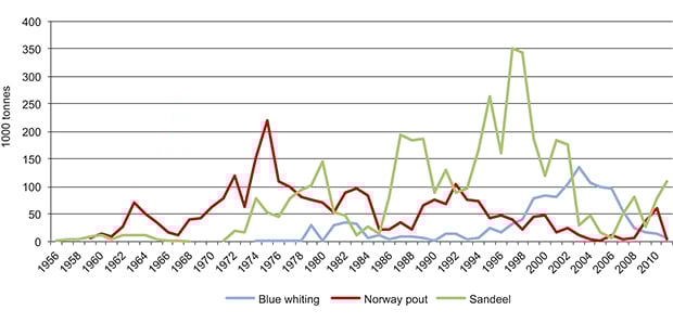
Figure 3.11 Norwegian industrial fisheries in the North Sea from the 1950s to the present. Fisheries for blue whiting, Norway pout and sandeels are generally called industrial fisheries because the catches are used for production of fish meal and oil.
Source Institute of Marine Research
Sandeels
Sandeel is the name used for any of several species of the family Ammodytidae, but it is the lesser sandeel (Ammodytes marinus) that dominates catches. Sandeels live on sandy substrate, and are patchily distributed in the open sea and along the coast. They spend long periods burrowing in the sand. The sandeel stock in the North Sea probably consists of a number of distinct and geographically isolated components, and this must be taken into account in their management. Sandeels are important prey for other fish, marine mammals and seabirds, and thus play a key role in the ecosystem. The sandeel fishery was previously completely unregulated, and this led to intense fishing pressure and negative impacts on spawning stocks. The fishery is therefore now much more limited. Denmark and Norway dominate the sandeel fishery, which takes place on the Viking Bank and in central parts of the North Sea. Between 1990 and 2002, annual landings varied around an average of 815 000 tonnes, but have since been considerably lower. The decline was particularly steep in the Norwegian zone, where catches were 88–94 % lower in the period 2003–05 than in 1994–2002. In the EU zone, catches dropped by 44–74 % in the same period. It is only in recent years that quotas have been set for the sandeel fishery in the North Sea. In the Norwegian zone, a new area-based management model was introduced in 2010. Its main aim is to build up and safeguard viable spawning stocks in all historically important sandeel areas (see Box 4.1), and the Institute of Marine Research is responsible for annual acoustic surveys of the distribution and quantity of sandeels. A strong 2009 year class and healthy individual weights resulted in a considerable increase in sandeel biomass and distribution in Norway’s Exclusive Economic Zone from 2009 to 2010. However, there are also natural fluctuations in recruitment, and for the last two years this has been weak. The stock now consists largely of the 2009 year class and a proportion of older fish.
Shrimps
The shrimp Pandalus borealis prefers deep water, generally deeper than 70 metres, but can also be found at depths of as little as 15–20 metres. This is a cold-water species that is widely distributed on both sides of the North Atlantic. It is found from the Skagerrak and along the entire Norwegian coast to north of Svalbard. It prefers a clay or muddy substrate, where it feeds on small crustaceans and polychaetes, and also on detritus. At night, it migrates upwards through the water column to feed on zooplankton. Shrimps are important prey for many demersal fish species, especially cod.
There is a longer time series of Danish than of Norwegian catch rates, and they show that the shrimp stock declined from 2007 to 2010. Recruitment was lower in 2008–11 than in 2006 and 2007, suggesting that the stock will remain low. Recruitment increased in 2011 and 2012.
Shrimps are caught using single or pair trawls. A growing number of vessels are using trawls in which a sorting grid is mounted. Where sorting grids are not used, the harvest includes bycatches dominated by saithe and cod, and also containing various deep-water fish and sharks in the deeper parts of the Skagerrak and in the Norwegian Trench. There are regulatory measures relating to such bycatches, which may make up as much as 30 % of the total catch.
Mackerel
Mackerel are found from northwestern Africa to the Barents Sea. In the Northeast Atlantic, they are managed as a single stock with three spawning components. North Sea mackerel spawn in central parts of the North Sea and in the Skagerrak, western mackerel spawn west of Ireland, and southern mackerel spawn in Spanish and Portuguese waters. The North Sea spawning component is the smallest of the three. It was severely depleted in the 1970s and has remained at a very low level ever since. Regulatory measures including closed areas now prevent fishing for North Sea mackerel. Mackerel are typical plankton feeders even as adults, but also feed on fish larvae and juvenile fish. After a long period of relative stability, the overall spawning stock biomass rose from 1.7 million tonnes in 2002 to 3 million tonnes in 2009.
The 2005 and 2006 year classes are the strongest in the whole time series, closely followed by the 2002 year class. The 2007 and 2008 year classes were also above average in size, but higher fishing mortality is increasing the risk that harvesting is not sustainable. Since 2010, there has been no international coastal state agreement on a TAC for mackerel, which is the explanation for the relatively high harvest. Iceland and the Faroe Islands have started to take significant catches in their own economic zones, and despite a number of negotiation rounds, it has not been possible to reach agreement on a TAC and how to share it. The mackerel stock as a whole is in very good condition, despite the fact that catches have been substantially higher than recommended by ICES for several years.
North Sea herring
The herring is a pelagic, schooling species. North Sea herring are found in the North Sea, Skagerrak and Kattegat. There are autumn-, winter- and spring-spawning herring in this area, but autumn-spawning North Sea herring dominate. Herring are plankton feeders and a key species in the ecosystem both as predators and as prey for other fish species, seabirds and marine mammals. Heavy fishing pressure and low recruitment over a number of years led to a collapse of the spawning stock, which reached a historical low in 1978. Stricter regulatory measures have helped the stock to recover. Although recruitment has not been good since 2001, the North Sea herring stock is still at full reproductive capacity.
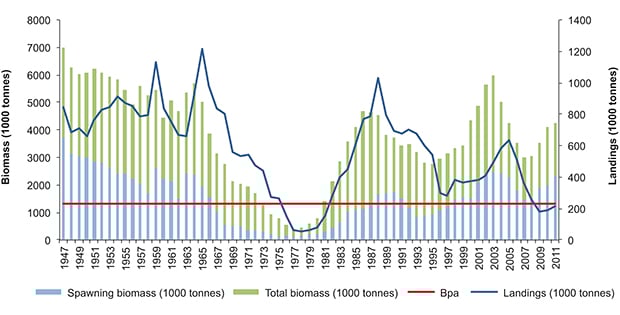
Figure 3.12 Changes in the spawning stock and catches of North Sea herring, 1947–2011. Bpa: precautionary spawning stock reference point.
Source Institute of Marine Research
Sprat
The sprat is a small schooling species of the herring family, with its main distribution area in central and southeastern parts of the North Sea. In the Skagerrak it is found mainly inshore and in Norwegian and Swedish fjords. The information available is not sufficient to evaluate the status of the sprat stock in the North Sea and Skagerrak. ICES has concluded that although the distribution of the stock is expanding, catches are remaining more or less constant. The current fishing pressure is therefore considered to be sustainable.
Spiny dogfish and bluefin tuna
There were previously relatively large fisheries for spiny dogfish and bluefin tuna in the North Sea. The spiny dogfish was the commonest shark species in the Northeast Atlantic, but the stock has declined substantially. However, there are no good estimates of stock size. The species is classified as critically endangered on the 2010 Norwegian Red List. The bluefin tuna stock, which spawns in the Mediterranean Sea, has also been severely depleted and no longer feeds in Norwegian waters. However, researchers believe that the stock is now increasing, and a number of bluefin tunas have been observed further north in the Atlantic Ocean in recent years. Several regulatory measures have been introduced in Norway to improve protection of these species, including a complete ban on fishing specifically for both species.
3.3.5 Marine mammals
Five species of marine mammals are numerically dominant in the North Sea: three whale species (common porpoise, minke whale and white-beaked dolphin) and two seal species (grey seal and common seal). Minke whales make a feeding migration into the North Sea during the summer, while the other four species are all resident in the area. In addition, there is a small resident population of bottlenose dolphins on the east coast of Scotland. Other species of seals and whales also spend shorter periods of time in the North Sea.
There are no long time series on the abundance of whales in the North Sea. Two large-scale international surveys in 1994 and 2005 showed that the porpoise population was stable (about 1/3 million) during this period, but that there was a southerly shift in their distribution. The number of minke whales and white-beaked dolphins was also stable during this period. However, the number of minke whales that move into the North Sea in summer can vary from year to year.
Rather longer time series are available for seals, and show considerable changes over the past 50 years. Information on numbers of grey seals is based on counts of pups, while the whole population of common seals is counted at haul-out sites during the moult.
The grey seal population is found largely around the British Isles, and pup production has risen from about 5 000 in 1960 to almost 40 000 in 2010. By way of comparison, only about 45 pups a year are born along the Norwegian North Sea coast, but the number is rising. Since they were protected, grey seals have re-colonised areas where they used to breed in Danish, German and Dutch waters.
Common seals have increased in numbers in the second half of the 20th century, since the North Sea countries introduced protection measures. Common seals were protected in the southern half of Norway in 1973, but since then a regulated hunt has been opened in some areas. Two outbreaks of disease, in 1988 and 2002, caused considerable mortality along the mainland coast of Europe and in England, but the populations recovered quickly. Around 2010, the Norwegian North Sea populations numbered about 1 000 common seals in the North Sea part of the management plan area, and about 300 in the Skagerrak. The populations in Scotland and along the Norwegian coast from Rogaland and northwards were not much affected by these disease outbreaks. However, in the last few years the large Scottish populations have declined dramatically (by 50 % in Shetland and 68 % in Orkney). The reasons for this are not clear, but the decline is not believed to be linked to the earlier outbreaks of disease. The common seal population also appears to have shown a weak decline in Norway in recent years. The species is classified as vulnerable on the 2010 Norwegian Red List.
The short-beaked common dolphin and striped dolphin are both very abundant in the Atlantic Ocean south of the British Isles. If climate change results in higher water temperatures in the North Sea, these species may become established in large numbers here. This could alter the competitive balance between these species and the traditional North Sea dolphin species.
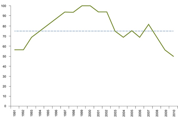
Figure 3.13 The proportion of 16 species in the North Sea that were within the target levels of abundance defined in OSPAR’s ecological quality objective for seabird population trends in the period 1991–2010. The objective is not achieved in years when the proportion drops below 75 %. The vertical axis shows the percentage of the species that achieve target levels.
Source OSPAR
3.3.6 Seabirds
The North Sea–Skagerrak area is used by many seabird populations. A large proportion of the seabirds found here breed in the southern half of Norway and northeastern parts of Britain. At the end of the breeding season, seabirds from these parts of Britain move offshore to the North Sea. The area also attracts large numbers of seabirds from the Norwegian Sea and the Barents Sea. Thus, the management plan area includes important migration routes and staging and wintering areas for a wide variety of seabird species. The breeding seabird populations in the Norwegian part of the North Sea and Skagerrak are estimated at 133 000 and 101 000 pairs respectively. This means that 12 % of all Norway’s seabirds breed in the area, particularly coastal species (gulls, terns, cormorant and shag, and common eider). The breeding populations of common eider, common gull, lesser black-backed gull and herring gull are largest, followed by Atlantic puffin, great black-backed gull, common tern, Arctic tern and black-legged kittiwake.
There are many seabird colonies along the Norwegian North Sea and Skagerrak coast, but not large cliff-based colonies such as those found further north. Birds from the large colonies on Runde island in the southern part of the Norwegian Sea feed in the northern North Sea. Einevarden in Sogn og Fjordane is one of the few colonies south of Runde where auks, kittiwakes and northern fulmar breed. Norway has a special responsibility for some species that occur in the North Sea and Skagerrak because more than 25 % of the European population breeds in Norway. These include the common gull, lesser black-backed gull (subspecies intermedius) and herring gull.
Seabirds are an important component of coastal and marine ecosystems, partly because they are a highly visible top trophic level in long food chains. Population trends, survival and reproduction in seabirds are good indicators of the state of marine ecosystems.
Generally, the trend is that populations of pelagic seabirds (those that feed out at sea) in the North Sea and Skagerrak are declining. The same applies to many coastal species, but the picture is more varied for this group. Recently established species such as the northern gannet and cormorant (subspecies sinensis) are increasing, whereas the common gull, kittiwake, common tern, puffin and common guillemot are declining. The management plan area is changing, and this is reflected in seabird species composition. Eleven species of seabirds that occur in the management plan area are included on the Norwegian Red List, and six of them are considered to be threatened.
3.3.7 Threatened species
Red lists have become an important tool in national and international management of biodiversity. They are drawn up using the categories and criteria adopted by the International Union for Conservation of Nature (IUCN) as a basis. «Threatened species» is a generic term that covers three categories: critically endangered, endangered and vulnerable. A set of five criteria is used to determine the category in which a particular species should be placed, using information on geographical range and population size and trend.
The categories for Norway’s red-listed fish and marine mammals have largely been determined on the basis of information on population reductions, and the information available on fish stocks is largely based on monitoring of stocks and of recruitment to commercial fish stocks. In contrast, our information on seaweeds, kelp and invertebrates consists mainly of registered finds and knowledge about the habitats they occur in and their extent. For these groups, red-list categories have therefore largely been assessed on the basis of this information. The main threats to most threatened and near-threatened marine species are disturbance of the seabed and habitats, eutrophication and harvesting.
Textbox 3.4 The 2010 Norwegian Red List for species
The most important elements of the IUCN criteria are as follows:
Population reduction. Used for species whose population has recently declined, or is expected to do so in the near future.
Limited geographical range combined with severe fragmentation, continuing population decline or range, or extreme fluctuations.
Small population size and decline and/or unfavourable population structure.
Very small population or very restricted range.
Vertebrate species that occur in the management plan area and are listed in one of the «threatened» categories in the Norwegian Red List
Species name | Red list category |
|---|---|
European eel | Critically endangered |
Blue skate | Critically endangered |
Spiny dogfish | Critically endangered |
Basking shark | Endangered |
Blue ling | Endangered |
Golden redfish | Endangered |
Porbeagle | Vulnerable |
Common guillemot | Critically endangered |
Black-legged kittiwake | Endangered |
Razorbill | Vulnerable |
Black guillemot | Vulnerable |
Atlantic puffin | Vulnerable |
Common tern | Vulnerable |
The Red List is a dynamic tool that is regularly revised to incorporate new knowledge about the population status of different species. Marine species were included in the Norwegian Red List in 2006, and new assessments resulted in changes in 2010; some species were removed from the list, while others were moved from the category «data deficient» to one of the threatened categories.
In addition to the species listed in Box 3.4, some invertebrates have been classified as threatened. These include some molluscs (including the sand gaper and European flat oyster), five species of gastropods and a few small crustaceans, including the Atlantic ditch shrimp. Many invertebrates on the Red List are in the category «data deficient», because so little is known about their population status and trends.
The marine species that have been included on the Red List were assessed on the basis of the scientific knowledge available at the time. In many cases, only limited data was available for these species, often based on catch reports. Catch data have limitations because of variations over time in fishing effort and regulatory measures. A precautionary approach is taken when there is uncertainty about the population trend. The fisheries authorities take the need for extraordinary measures or monitoring into account in their annual budgets, and set priorities for measures targeting individual species on the basis of recent information on trends and changes in harvesting patterns, stock status and knowledge needs. Fishing specifically for most of the red-listed species is completely prohibited.
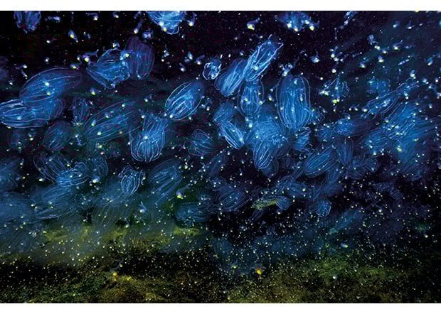
Figure 3.14 The comb jelly (Mnemiopsis leidyi)
Source Photo: Erling Svendsen
3.3.8 Alien species
Alien species are species that have been intentionally or unintentionally introduced outside their natural past or present distribution by human agency.
Many of these species meet environmental conditions that are so different from those they prefer that they are unable to survive. Others find conditions that allow them to grow and survive, and establish local populations. A few species find favourable environmental conditions and lack natural enemies (especially during the colonisation phase). Such species may after a time reach very high densities, displace native species and disrupt local ecosystems. They are known as invasive alien species.
The probability that a particular alien species will survive transport to a new area, and in addition turn out to be adapted to conditions in its new environment and be able to establish a reproducing population is low, but this does happen in a proportion of cases. The probability that new alien species will become established rises with invasion pressure, which is determined by the number of individuals arriving in an area and the frequency of introductions.
Alien species originally evolved in their native ecosystems in interaction with many other species that are not present in the new ecosystem. This makes it difficult to predict what impacts they will have. In the absence of such knowledge, alien species are often assumed to be invasive until otherwise demonstrated.
A number of alien species have become established in Norwegian waters. In the management plan area, most of them are benthic species found near the coast, such as Pacific oysters (Crassostrea gigas) and japweed (Sargassum muticum). The comb jelly Mnemiopsis leidyi (see Figure 3.14) is a pelagic species that has been observed at very high densities along Norway’s North Sea coastline.
The Norwegian Biodiversity Information Centre has published official lists of alien species in Norway. The first was the 2007 Norwegian Black List, and an updated version, Alien species in Norway with the Norwegian Black List, was published in 2012. Not all Norwegian sea areas are covered by systematic mapping and monitoring of alien species, but 10 permanent monitoring stations have been established along the coastline. Observations from these together with results from other monitoring programmes will give some indication of developments, but are unlikely to reveal new introductions at a very early stage. A number of the alien marine species that have become established in other parts of Europe are likely to be able to spread to Norway.
3.3.9 Nature Index for the North Sea and Skagerrak
The Norwegian Nature Index is intended to document the state of biodiversity and trends over time in major Norwegian ecosystems.
A set of indicators has been chosen to represent biodiversity in each of these ecosystems. Indicators may be species or indirect indicators that give information on the biodiversity potential of an area. In all, the Nature Index uses more than 300 indicators from nine major ecosystems.
Nature Index values have been calculated for seabed and pelagic ecosystems in the North Sea, the Skagerrak and coastal waters. The calculated values for the North Sea and Skagerrak fell steeply between 1950 and 1990. After this, the values for the North Sea levelled off or improved slightly from 1990 to 2010, whereas the decline continued for the pelagic ecosystem of the Skagerrak from 1990 to 2000, and it was only after this that a positive trend emerged.
Even if Nature Index values show a positive trend or no change in an ecosystem, there may be significant changes that are not revealed by the aggregated data.
The selection of indicators is based on expert assessments, monitoring data and modelling. At present, they do not give a complete picture, because there are few indicators for the marine ecosystems (seabed and pelagic) and the set of indicators is skewed. Both the number and the coverage of the indicators need to be improved for the North Sea and Skagerrak.
Information from the Nature Index must be supplemented with detailed information on trends for individual species and vulnerable areas. It has been difficult to collect adequate data for many of the ecosystems, and this adds to the uncertainty of the calculations.
The Nature Index reveals considerable gaps in our knowledge about a number of ecosystems and species groups. Marine species that are commercially exploited have been monitored and actively managed for many years, but more information is needed about benthic species and non-commercial fish species. It is particularly important to establish and maintain long time series. The gaps in our knowledge are greatest for the major ecosystem type «coastal waters». Coordination between the Advisory Group on the Monitoring of Sea Areas and the Nature Index needs to be improved as the index is further developed.
3.4 Particularly valuable and vulnerable areas
Particularly valuable and vulnerable areas are those that on the basis of scientific assessments have been identified as being of great importance for biodiversity and for biological production in the entire North Sea-Skagerrak area. Areas may for example be identified as particularly valuable and vulnerable because they are important habitats or spawning grounds for fish, important habitats for seabirds, or contain coral reefs. Areas were selected using predefined criteria. The main criteria were that the area concerned was important for biodiversity or for biological production. In addition, a number of secondary criteria were evaluated, for example economic, social and cultural importance, and scientific value.
The vulnerability of valuable areas to various environmental pressures has also been assessed on the basis of the species and habitats that occur naturally in each area and their productivity. The vulnerability of a habitat or species to different environmental pressures varies, and has been assessed on the basis of the likely impacts of different pressures on species or habitat development and survival. There may also be temporal and spatial variations in vulnerability. The vulnerability of an area is considered to be an intrinsic property of the species and habitats to be found there, regardless of whether or not specific environmental pressures are actually acting on them.
Textbox 3.5 Vulnerability
Vulnerability can be defined as a measure of how liable a species or habitat is to be negatively affected by external, often anthropogenic pressures.
Thus the vulnerability of an area is considered to be an intrinsic property of the species and habitats to be found there, regardless of whether or not specific environmental pressures are actually acting on them. An assessment of the vulnerability of an area is generally based on which species and habitats occur naturally in the area and their productivity. Factors such as seasonal variations, distribution patterns, age/stage of the life cycle, behaviour and biological characteristics are used to determine the vulnerability of a particular species. Vulnerability to environmental pressures is assessed on the basis of the likely impacts of different pressures on the development and survival of a species or population. Some species are particularly vulnerable at times of the year when most of the population is concentrated in a limited area (for example fish during spawning and seabirds during the breeding season). The vulnerability of habitats depends on factors such as the substrate type (for example sand or rock), whether it contains sessile or motile species, and whether the habitat type is rare. Certain areas dominated by long-lived, habitat-forming species such as corals and sponges may be particularly vulnerable to certain environmental pressures because habitat formation is a very slow process. Areas where biological production is high may be particularly vulnerable at certain times of year (for example when eggs and larvae (the early stages of fish) are present). Cumulative environmental effects may increase vulnerability. Vulnerability can be measured at individual, population, community and ecosystem level. For management purposes, impacts at population, community and ecosystem level are most important.
The designation of areas as particularly valuable and vulnerable does not have any direct effect in the form of restrictions on commercial activities, but indicates that these are areas where it is important to show special caution. To protect particularly valuable species and habitats, it is for example possible to use current legislation to make activities in such areas subject to special requirements. Such requirements may apply to the whole of a particularly valuable and vulnerable area or part of it, and must be considered on a case-by-case basis.
The scientific basis for the management plan identifies 12 particularly valuable areas on the basis of scientific assessments, eight along the coast and four in the open sea (in the North Sea). All 12 areas are generally vulnerable, but their vulnerability varies depending on which pressures act on them and at which times of year (see Box 3.5 on vulnerability). In addition, the coastal zone has been identified as a generally valuable area.
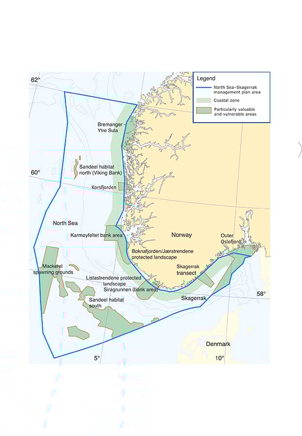
Figure 3.15 Particularly valuable and vulnerable areas in the North Sea and Skagerrak
Source Directorate for Nature Management, Norwegian Mapping Authority.
A brief description of each of the particularly valuable and vulnerable areas in the North Sea and Skagerrak is given below:
1) Bremanger-Ytre Sula
This is an important breeding, moulting, passage and wintering area for seabirds, and an important whelping area for the common seal.
2) Korsfjorden
The qualities that are considered to make the area particularly valuable are its habitat, landscape and geological diversity, the kelp forests and rich bird life, and its cultural history. The area has particularly large stands of kelp forest (Laminaria hyperborea) and shell sand deposits. This is a varied coastal area that is representative of the islands and skerries along the coastline of Western Norway and shows considerable variation in underwater topography.
3) Karmøyfeltet bank area
Biological production is high in this area. Karmøyfeltet includes spawning grounds for Norwegian spring-spawning herring and retention areas for drifting fish eggs and larvae, which makes it attractive to predators such as seabirds and marine mammals. The area is important at ecosystem level because there are large concentrations of shrimps, a key species in the ecosystem.
4) Outer Boknafjorden/Jærstrendene protected landscape
This area has a number of distinctive features and includes large tracts of shallow water with sandy and rocky bottom. Strong wave action and currents result in a physically dynamic environment, with a specialised fauna that are able to live in such challenging conditions. The geological and ecological diversity of the area is high, ranging from open sea areas in the west via shallow kelp forest, beaches that are rich in drift seaweed and sand dune systems, to nutrient-rich lakes and mires in the east. The sand dune systems are of international value and thousands of waders congregate to rest and forage for food along the shoreline during migration. This is also a whelping ground for common seals and includes a number of protected areas.
5) Listastrendene protected landscape
This is an extremely important area for birds. It is also a type locality for sand dune landscape and supports an interesting sand dune flora. The area includes the oldest known end moraine in Norway. There are also raised beaches and vegetation characteristic of shingle beaches and nutrient-rich mires.
6) Siragrunnen bank area
The area provides good spawning conditions and food supplies for a number of fish species. It is a spawning ground for Norwegian spring-spawning herring and a retention area for pelagic fish eggs and larvae. This makes it attractive to predators such as seabirds and marine mammals. Siragrunnen is also one of the most important areas in the region for lobster.
7) Skagerrak transect
Habitat and landscape diversity are high in this area, and there are valuable geological features. It is also important because of its bird life and cultural history. The transect extends from the shoreline on the seaward side of the islands and skerries, between the northern point of Tromøya off Arendal and the land-locked bay Ruakerkilen near Fevik, and out to a depth of about 600 metres in the Norwegian Trench. The transect includes the intertidal zone, a terminal moraine (Raet), brackish-water areas at the mouth of the river Nidelva, the seaweed zone, eelgrass beds, soft-bottom areas, hard-bottom areas with kelp forests and corals, and an area that is closed to lobster trapping. The area is representative of the Skagerrak.
8) Outer Oslofjord
The outer Oslofjord includes Ormø–Færder protected landscape and Ytre Hvaler national park. Ormø–Færder protected landscape provides habitats for a number of rare and threatened plant and animal species, has a rich bird life and offers a range of opportunities for outdoor recreation. Ytre Hvaler national park is a breeding, passage and wintering area for seabirds, and has the world’s largest recorded coral reef in inshore waters. Conditions in the area are very distinctive because of the influence of the Glomma (Norway’s largest river), which flows into the sea here. There is also wide variation in underwater topography and seabed conditions.
9 ) The Skagerrak
This is a moulting and wintering area for seabirds, and a large proportion of Norway’s common guillemot population is found here from late summer to winter. The common guillemot is now classified as critically endangered after a dramatic population decline in recent years.
10–11) Sandeel habitat north (Viking Bank) and south
The Viking Bank is a habitat and spawning ground for sandeels and a feeding area for whales that feed on sandeels. Sandeels are a key species in the North Sea ecosystem, and are stationary because they have a strong preference for a seabed of coarse sand in which they can burrow. Sandeels are also an important commercial species.
Sandeel habitat south includes several other areas of habitat and spawning grounds for sandeels in the central parts of the North Sea.
12) Mackerel spawning grounds
This covers the most important spawning areas for mackerel, which is an ecologically and commercially important stock in the North Sea.
The coastal zone
In addition to the list above, the coastal zone out to 25 km from the baseline has been identified as a generally valuable area. The topography is varied and complex, with a high diversity of underwater habitat types and a rich flora and fauna. The area is important for seabirds, and is used by both seals and whales. The actual shoreline and beach habitats are also important. Species and habitats along the shoreline can be vulnerable to oil pollution, litter, bycatches, and expansion of recreational activities.
3.5 Important knowledge needs
An extensive knowledge base has been developed on the ecosystems and state of the environment in the North Sea and Skagerrak, and this is considered to be one of the most thoroughly investigated marine areas in the world. Nevertheless, there is still a need to improve knowledge about pressures and impacts on ecosystems as a result of climate change, acidification and human activity. Mapping, monitoring and research will all be needed.
To make it possible to assess the probability and impacts of drastic changes in ecosystems (ecological regime shifts), more knowledge is needed about the resilience of ecosystems to climate change, ocean acidification and pollution. It is important to obtain more information about which species and benthic and other habitat types are vulnerable to change. We also need to know more about how climate change and ocean acidification may influence the pollution status of the management plan area in the future.
More and more new hazardous substances are being detected in the environment, but we know little about their impacts. It is essential to set up monitoring programmes and develop new methods to detect the potentially most dangerous pollutants. We need to know more about the effects of long-term exposure and the combined effects of exposure to mixtures of different pollutants, both new and old substances.
More data is needed on hazardous substances in the open sea, and there are few studies that provide information on pollution loads in marine organisms.
It is also important to develop technology and know-how that can be used to prevent or reduce anthropogenic pressures and impacts. Knowledge about ecosystem services that are not linked to a specific market or branch of industry is also needed, so that we can build up an overall picture of the importance of the management plan area for people and society.